Please wait a minute...
 
自然资源遥感  2023, Vol. 35 Issue (2): 97-104    DOI: 10.6046/zrzyyg.2022158
  技术方法 本期目录 | 过刊浏览 | 高级检索 |
基于Mask R-CNN的遥感影像疏林地智能识别方法
刁明光1(), 刘勇1, 郭宁博1, 李文吉2, 江继康1, 王云霄1
1.中国地质大学(北京)信息工程学院,北京 100083
2.中国自然资源航空物探遥感中心,北京 100083
Mask R-CNN-based intelligent identification of sparse woods from remote sensing images
DIAO Mingguang1(), LIU Yong1, GUO Ningbo1, LI Wenji2, JIANG Jikang1, WANG Yunxiao1
1. School of Information Engineering, China University of Geosciences (Beijing), Beijing 100083, China
2. China Aero Geophysical Survey and Remote Sensing Center for Natural Resources, Beijing 100083, China
全文: PDF(5348 KB)   HTML  
输出: BibTeX | EndNote (RIS)      
摘要 

针对遥感影像疏林地提取方法少且精度不高,缺乏智能识别的数据集情况,提出了一套遥感影像疏林地智能识别方法。分别使用QGIS插件和Python语言对该方法进行实现,完成了数据集制作的环节,为模型训练提供了数据支撑; 通过特征提取生成特征图,在特征图中提取感兴趣区域(region of interest,ROI),通过池化操作(ROI align)对这些感兴趣区域进行过滤操作,减少因疏林地图像感兴趣区域过多而造成的内存消耗。实验表明,该方法可快速进行数据集制作,有效辅助遥感影像中疏林地的识别,使用基于Mask R-CNN的遥感影像疏林地智能识别方法对疏林地目标检测的均值平均准确率可以达到0.92。

服务
把本文推荐给朋友
加入引用管理器
E-mail Alert
RSS
作者相关文章
刁明光
刘勇
郭宁博
李文吉
江继康
王云霄
关键词 遥感影像疏林地深度学习Mask R-CNNQGIS    
Abstract

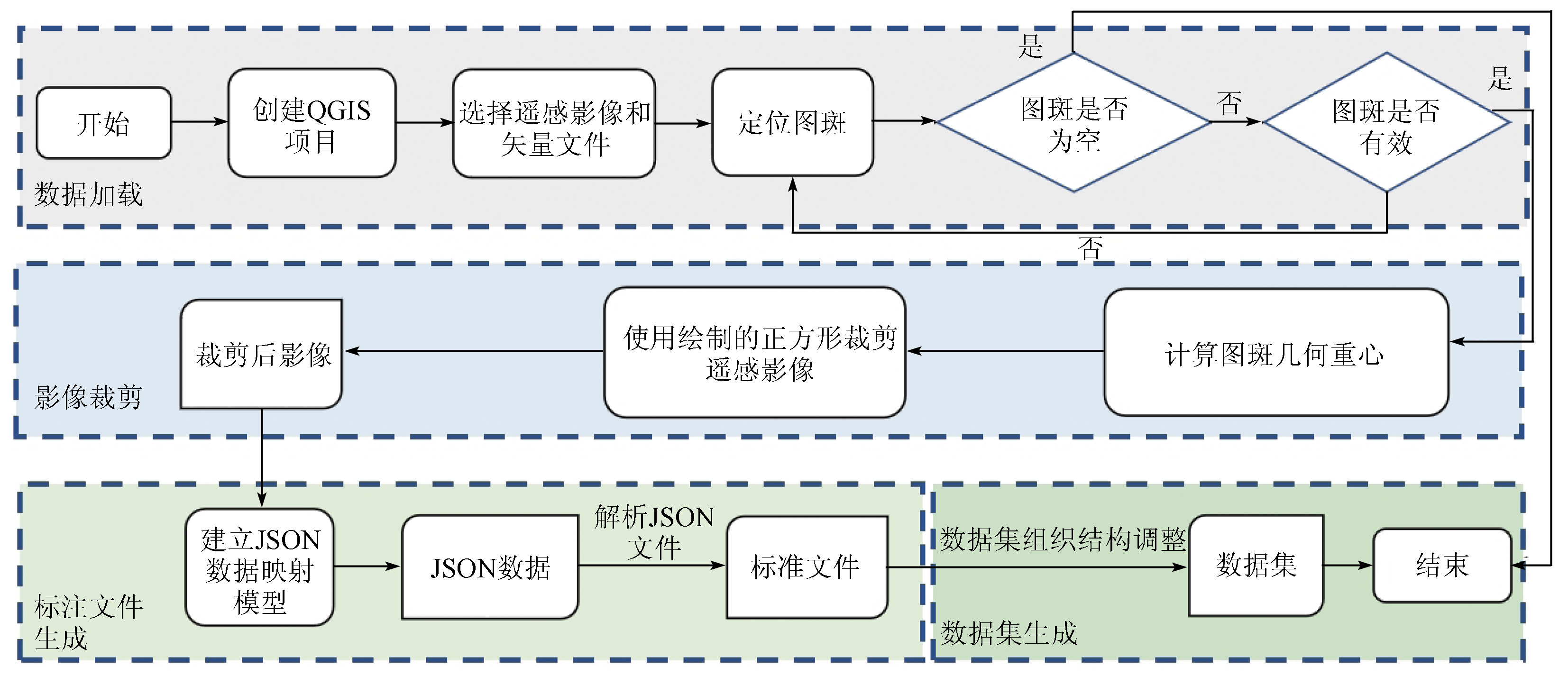
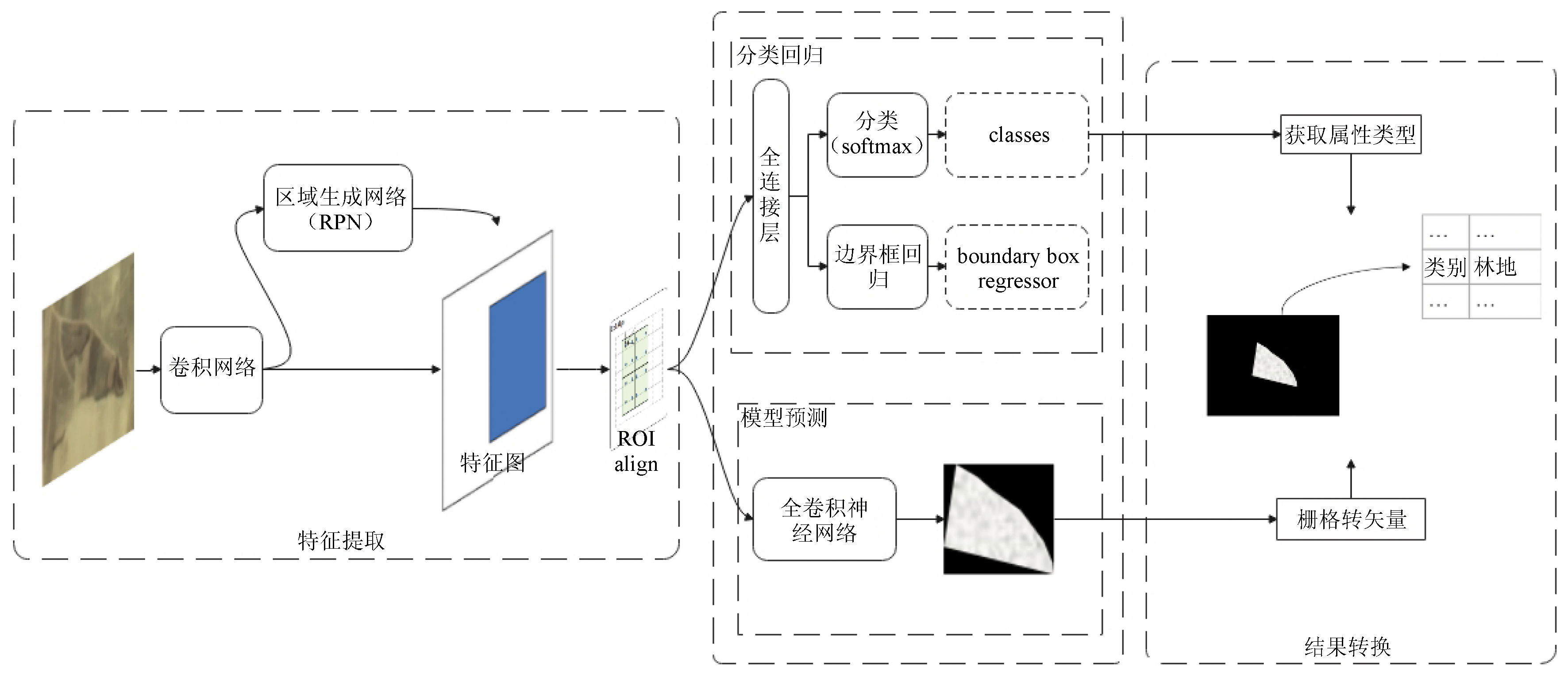
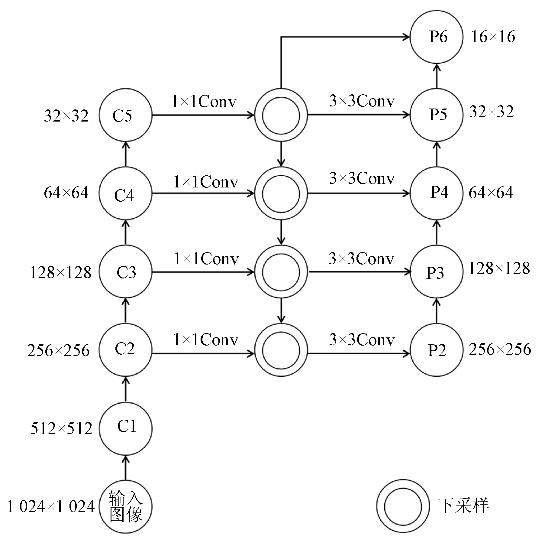
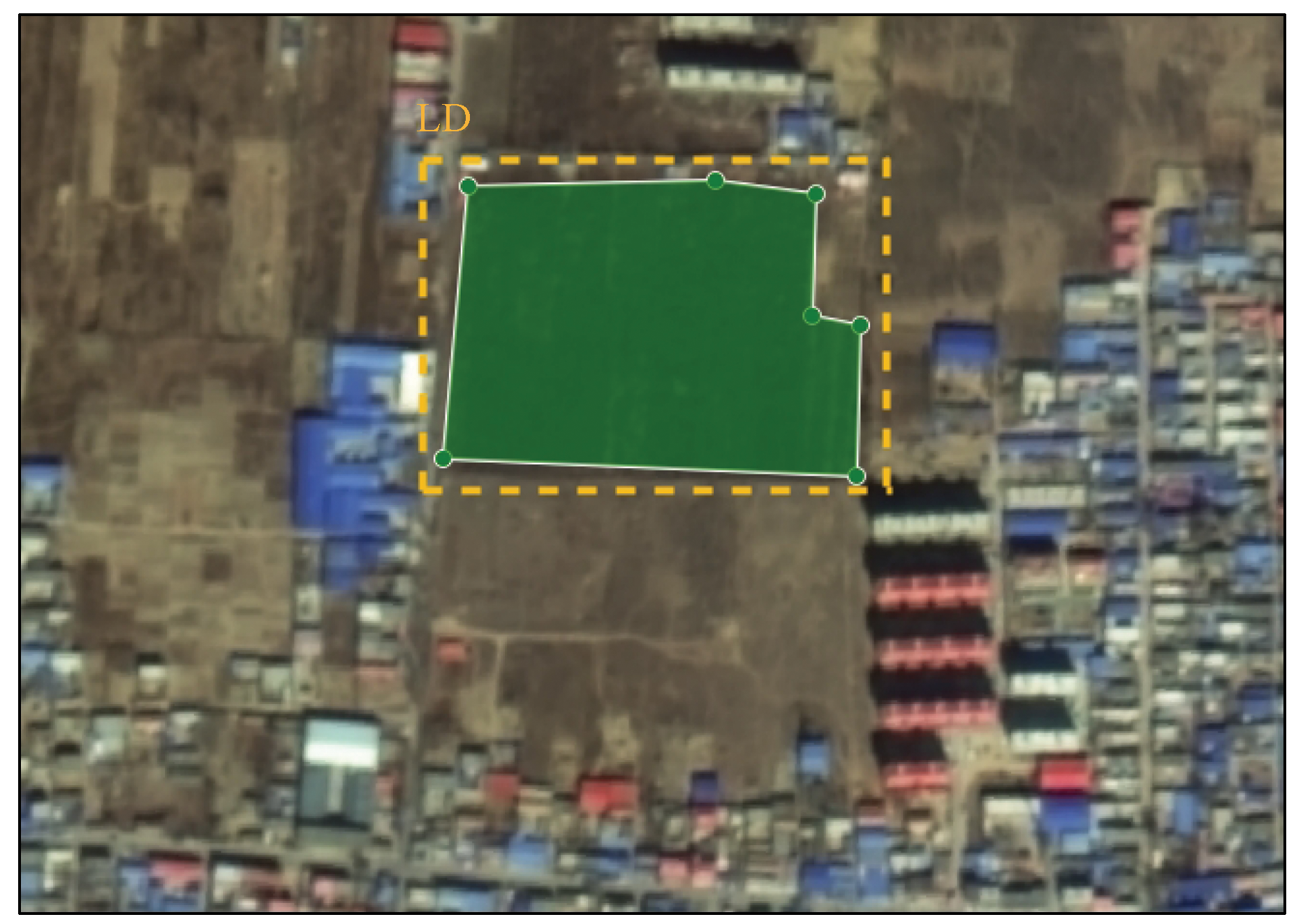
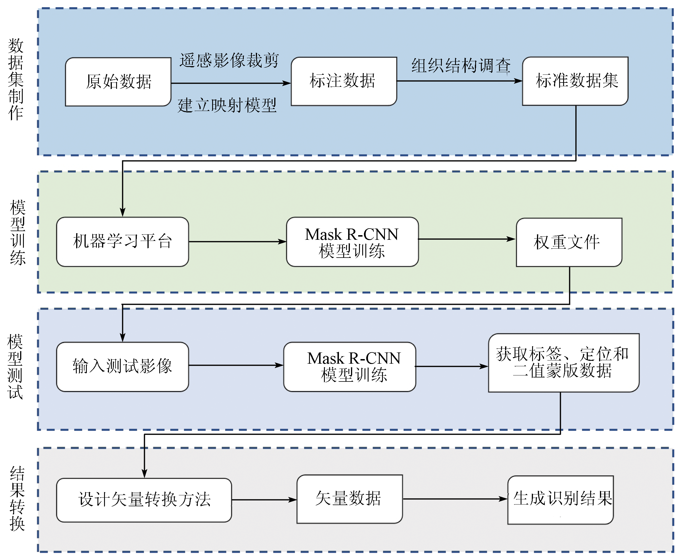
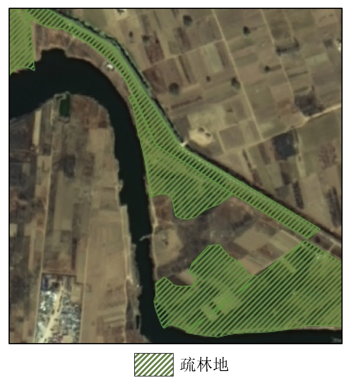
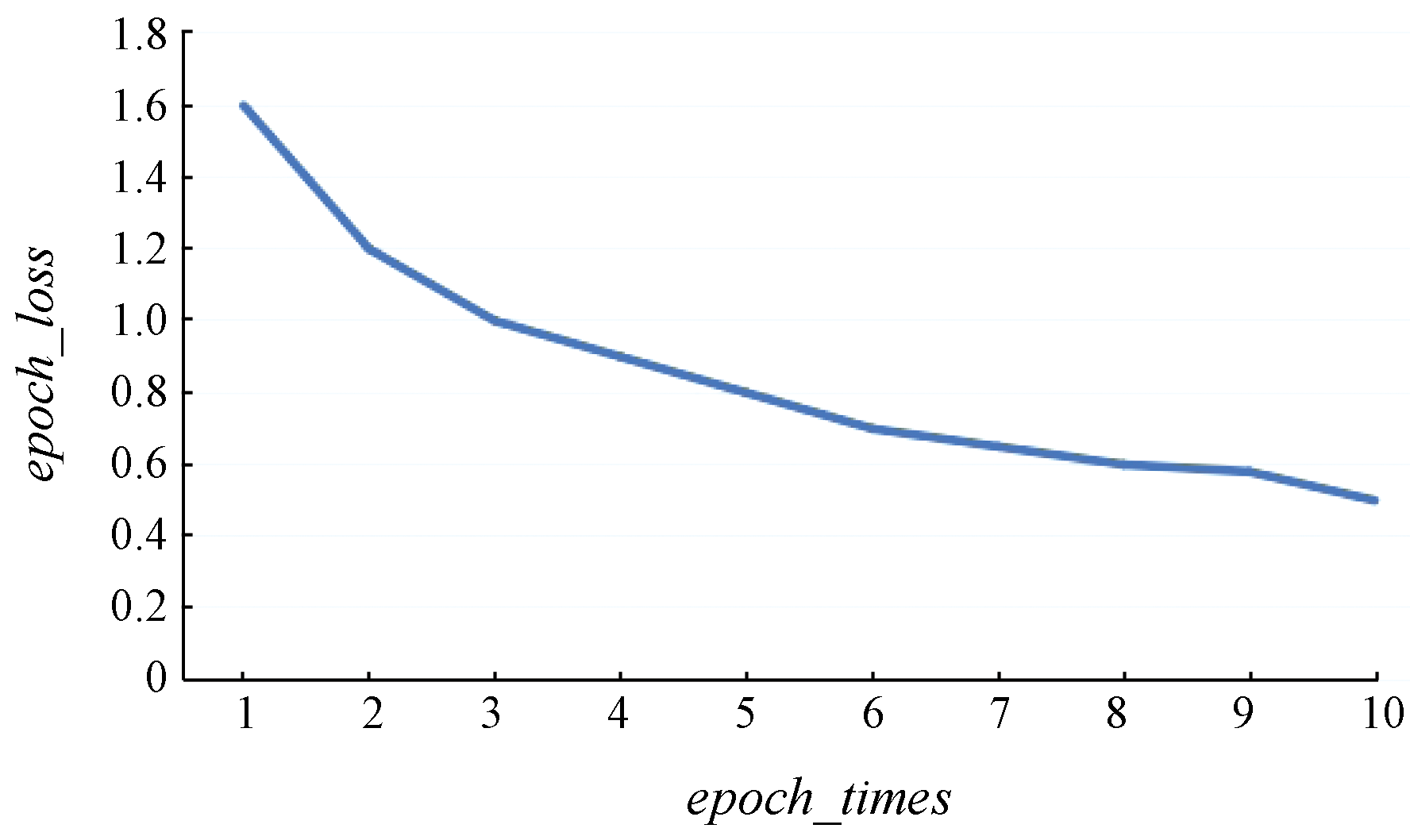
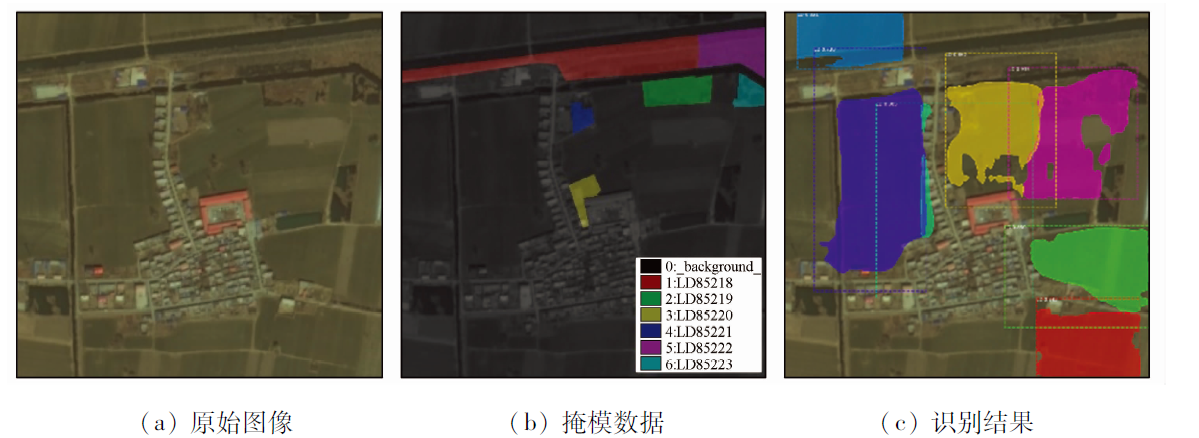
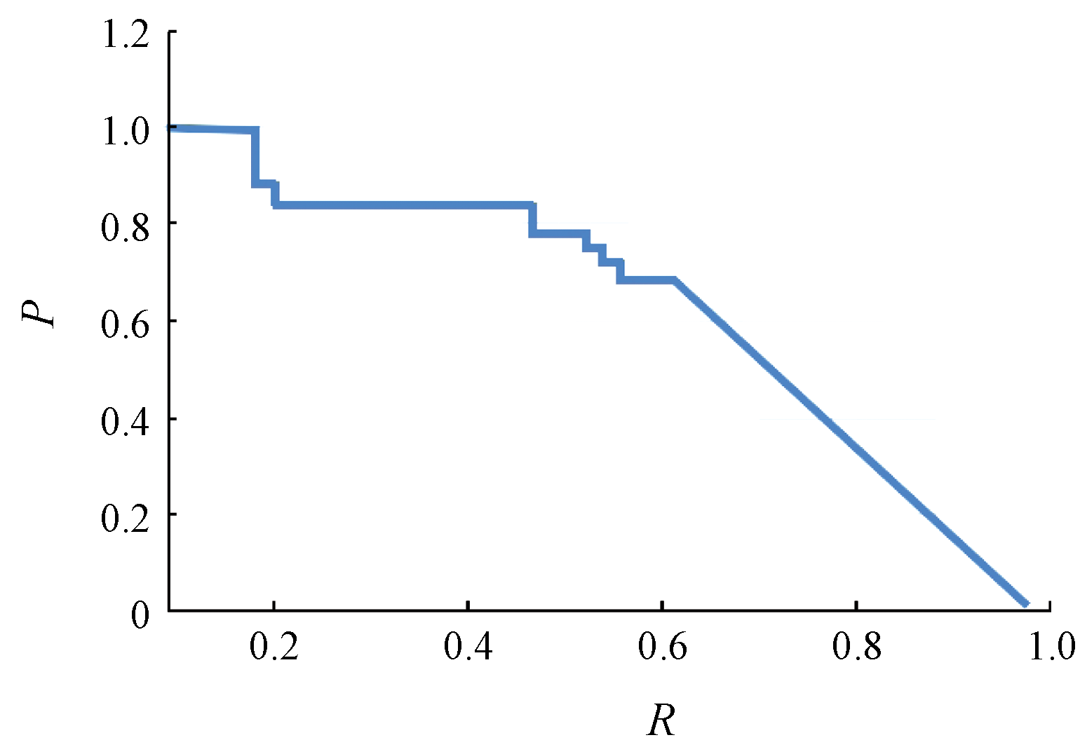
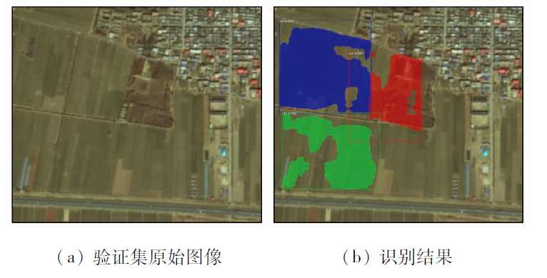
There are only a few low-accuracy methods available for the feature extraction of sparse woods from remote sensing images. Moreover, there is a lack of datasets for intelligent identification. This study proposed a method for intelligent information identification of sparse woods from remote sensing images. First, a dataset was created using QGIS and Python separately to provide data support for model training. Then, feature maps were generated through feature extraction, and then regions of interest (ROIs) were extracted from the feature maps. Subsequently, these ROIs were filtered through pooling operations (ROI align) to reduce the memory consumption caused by too many ROIs in the images. Experiments show that the method proposed in this study can create datasets quickly and facilitate the identification of sparse woods from remote sensing images. Moreover, the Mask R-CNN-based intelligent identification has a target detection mean average precision (MAP) of up to 0.92.

Key wordsremote sensing image    sparse woods    deep learning    Mask R-CNN    QGIS
收稿日期: 2022-04-22      出版日期: 2023-07-07
ZTFLH:  TP751  
基金资助:国家重点研发计划项目子课题“高亚洲和北极积雪-冰川与地质灾害数据可视化与算法集成研究”(2021YFE0116807);中国地质调查局地质调查项目“全国矿山开发状况遥感地质调查与监测”(DD20190511);中国自然资源部航空物理与遥感地质重点实验室课题“遥感影像典型矿山地物(露天采场)智能识别的研究与应用”(2020YF23)
作者简介: 刁明光(1970-),男,博士,副教授,主要从事地学信息工程、软件工程研究。Email: dmg@cugb.edu.cn
引用本文:   
刁明光, 刘勇, 郭宁博, 李文吉, 江继康, 王云霄. 基于Mask R-CNN的遥感影像疏林地智能识别方法[J]. 自然资源遥感, 2023, 35(2): 97-104.
DIAO Mingguang, LIU Yong, GUO Ningbo, LI Wenji, JIANG Jikang, WANG Yunxiao. Mask R-CNN-based intelligent identification of sparse woods from remote sensing images. Remote Sensing for Natural Resources, 2023, 35(2): 97-104.
链接本文:  
https://www.gtzyyg.com/CN/10.6046/zrzyyg.2022158      或      https://www.gtzyyg.com/CN/Y2023/V35/I2/97
Fig.1  遥感影像疏林地数据集生成流程
键名 说明
version LabelMe的版本号 可自动获取
flags 标志 可为空
shape_label 标签名,通常为类别名+编号 获取矢量信息中的类别,同一类别累加计数
shape_line_color 线条颜色 可为空
shape_fill_color 填充颜色 可为空
shape_points 掩模各个顶点的相对坐标 计算图斑上各点与矩形框左上角的坐标差
shape_type 掩模形状类型 point(点)、line(线)、polygon(多边形)
lineColor 线条颜色 可为空
fillColor 填充颜色 可为空
imagePath 原图路径 裁剪后影像的路径
imageData 64位值 图像转换
imageHeight 原始图像的高度 图像信息中获取
imageWidth 原始图像的宽度 图像信息中获取
Tab.1  JSON数据与矢量数据映射关系
数据集生成方法 数据源 数据量/
耗时/
h
人工制作方法 自然资源林地遥感影像 9 156 1 008
矿山遥感监测实例分割数据集自动生成方法 自然资源林地遥感影像 9 156 96
遥感影像疏林地数据集自动生成方法 自然资源林地遥感影像 9 156 7.5
Tab.2  不同数据集生成方法性能对比
Fig.2  遥感影像疏林地智能识别模型框架
Fig.3  ResNet-FPN网络结构
Fig.4  双线性插值计算过程
Fig.5  遥感影像疏林地智能识别模型结果转换效果
Fig.6  遥感影像疏林地智能识别方法框架
Fig.7  疏林地遥感数据局部影像和矢量数据
Fig.8  损失函数曲线
Fig.9  实验识别结果
Fig.10  实验验证集精确率召回曲线
Fig.11  验证集实验结果
[1] Everingham M, Eslami S M A, Van Gool L, et al. The pascal visual object classes challenge:A retrospective[J]. International Journal of Computer Vision, 2015, 111(1):98-136.
doi: 10.1007/s11263-014-0733-5
[2] Lin T, Maire M, Belongie S, et al. Microsoft COCO:Common objects in context[J]. Lecture Notes in Computer Science, 2014, 8693(1):740-755.
[3] Alex K, Ilya S, Geoffrey E H. ImageNet classification with deep convolutional neural networks[J]. Communications of the ACM, 2017, 60(6):84-90.
doi: 10.1145/3065386
[4] Xia G S, Bai X, Ding J, et al. DOTA:A large-scale dataset for object detection in aerial images[C]// 2018 IEEE/CVF Conference on Computer Vision and Pattern Recognition, 2018:3974-3983.
[5] 刘立, 彭刚. 高分辨率遥感影像线状地物提取方法研究[J]. 智能城市, 2021, 7(6):63-64.
Liu L, Peng G. Research on the extraction method of line features from high-resolution remote sensing images[J]. Intelligent City, 2021, 7(6):63-64.
[6] 林娜, 陈宏, 李志鹏, 等. 基于GF-1号影像的南方水稻种植信息提取[J]. 地理空间信息, 2021, 19(3):60-63.
Lin N, Chen H, Li Z P, et al. Information extraction of southern rice planting based on GF-1 image[J]. Geospatial Information, 2021, 19(3):60-63.
[7] 张冠宏, 王新军, 徐晓龙, 等. 基于面向对象的无人机遥感影像荒漠植被分类[J]. 中国农业科技导报, 2021, 23(5):69-77.
Zhang G H, Wang X J, Xu X L, et al. Desert vegetation classification based on object-oriented UAV remote sensing images[J]. Journal of Agricultural Science and Technology, 2021, 23(5):69-77.
doi: 10.13304/j.nykjdb.2020.0851
[8] 刘芸, 李雪, 廖瑶, 等. 基于面向对象分类法的贵州烤烟种植区域提取——以烤烟成熟期为例[J]. 贵州科学, 2021, 39(2):82-86.
Liu Y, Li X, Liao Y, et al. Extraction of roasted tobacco growing areas in Guizhou based on object-oriented classification method:Taking roasted tobacco maturity period as an example[J]. Guizhou Science, 2021, 39(2):82-86.
[9] Ke L, Gang W, Gong C, et al. Object detection in optical remote sensing images:A survey and a new benchmark[J]. ISPRS Journal of Photogrammetry and Remote Sensing, 2020, 159:296-307.
doi: 10.1016/j.isprsjprs.2019.11.023
[10] 杜敬. 基于深度学习的无人机遥感影像水体识别[J]. 江西科学, 2017, 35(1):158-161,170.
Du J. Deep learning based UAV remote sensing image water body identification[J]. Jiangxi Science, 2017, 35(1):158-161,170.
[11] 范荣双, 陈洋, 徐启恒, 等. 基于深度学习的高分辨率遥感影像建筑物提取方法[J]. 测绘学报, 2019, 48(1):38-45.
Fan R S, Chen Y, Xu Q H, et al. A high-resolution remote sensing image building extraction method based on deep learning[J]. Acta Geodaetica et Cartographica Sinica, 2019, 48(1):38-45.
[12] 刁明光, 于晨, 李文吉, 等. 矿山遥感监测实例分割数据集的自动生成方法[J]. 中国科技论文, 2021, 16(3):329-335.
Diao M G, Yu C, Li W J, et al. Automatic generation method of instance segmentation data set in mine remote sensing monitoring[J]. China Sciencepaper, 2021, 16(3):329-335.
[13] Menapace A, Pisaturo G R, De Luca A, et al. EPANET in QGIS framework:The QEPANET plugin[J]. Journal of Water Supply:Research and Technology-Aqua, 2020, 69(1):1-5.
doi: 10.2166/aqua.2019.087
[14] Zhang W W, Wang K F, Wang Y T, et al. A loss-balanced multi-task model for simultaneous detection and segmentation[J]. Neurocomputing, 2021, 428:65-78.
doi: 10.1016/j.neucom.2020.11.024
[15] He K, Gkioxari G, Dollár P, et al. Mask R-CNN[J]. IEEE Transactions on Pattern Analysis and Machine Intelligence, 2020, 42(2):386-397.
doi: 10.1109/TPAMI.2018.2844175 pmid: 29994331
[16] Huang Y J, Xu H X. Fully convolutional network with attention modules for semantic segmentation[J]. Signal,Image and Video Processing, 2021, 15(5):1031-1039.
doi: 10.1007/s11760-020-01828-8
[17] Miao J, Xu S W, Zou B X, et al. ResNet based on feature-inspired gating strategy[J]. Multimedia Tools and Applications, 2022, 81(4):19283-19300.
doi: 10.1007/s11042-021-10802-6
[18] Bai T, Pang Y, Luo J S, et al. An optimized faster R-CNN method based on DRNet and RoI align for building detection in remote sensing images[J]. Remote Sensing, 2020, 12(5):762.
doi: 10.3390/rs12050762
[19] 孙禧勇, 许玮, 姜德才, 等. 基于遥感的雄安新区地表水时序变化与区域规划研究[J]. 地球物理学进展, 2021, 36(4):1443-1455.
Sun X Y, Xu W, Jiang D C, et al. Research on time series changing trend of surface water and regional planning in Xiong’an New Area based on remote sensing[J]. Progress in Geophysics, 2021, 36(4):1443-1455.
[1] 刘立, 董先敏, 刘娟. 顾及地学特征的遥感影像语义分割模型性能评价方法[J]. 自然资源遥感, 2023, 35(3): 80-87.
[2] 牛祥华, 黄微, 黄睿, 蒋斯立. 基于注意力特征融合的高保真遥感图像薄云去除[J]. 自然资源遥感, 2023, 35(3): 116-123.
[3] 张仙, 李伟, 陈理, 杨昭颖, 窦宝成, 李瑜, 陈昊旻. 露天开采矿区要素遥感提取研究进展及展望[J]. 自然资源遥感, 2023, 35(2): 25-33.
[4] 邱磊, 张学志, 郝大为. 基于深度学习的视频SAR动目标检测与跟踪算法[J]. 自然资源遥感, 2023, 35(2): 157-166.
[5] 张可, 张庚生, 王宁, 温静, 李宇, 杨俊. 基于遥感和深度学习的输电线路地表水深预测[J]. 自然资源遥感, 2023, 35(1): 213-221.
[6] 胡建文, 汪泽平, 胡佩. 基于深度学习的空谱遥感图像融合综述[J]. 自然资源遥感, 2023, 35(1): 1-14.
[7] 赵凌虎, 袁希平, 甘淑, 胡琳, 丘鸣语. 改进Deeplabv3+的高分辨率遥感影像道路提取模型[J]. 自然资源遥感, 2023, 35(1): 107-114.
[8] 沈骏翱, 马梦婷, 宋致远, 柳汀洲, 张微. 基于深度学习语义分割模型的高分辨率遥感图像水体提取[J]. 自然资源遥感, 2022, 34(4): 129-135.
[9] 吕雅楠, 朱红, 孟健, 崔成玲, 宋其淇. 面向高分辨率遥感影像车辆检测的深度学习模型综述及适应性研究[J]. 自然资源遥感, 2022, 34(4): 22-32.
[10] 谭海, 张荣军, 樊文锋, 张一帆, 徐航. 融合多尺度特征的国产光学影像辐射异常分类检测[J]. 自然资源遥感, 2022, 34(4): 97-104.
[11] 苏玮, 林阳阳, 岳文, 陈颖彪. 基于U-Net卷积神经网络的广东省海水养殖区识别及其时空变化遥感监测[J]. 自然资源遥感, 2022, 34(4): 33-41.
[12] 张鹏强, 高奎亮, 刘冰, 谭熊. 联合空谱信息的高光谱影像深度Transformer网络分类[J]. 自然资源遥感, 2022, 34(3): 27-32.
[13] 程滔. 一种与遥感影像同步纠正的矢量地理信息采集方法[J]. 自然资源遥感, 2022, 34(3): 59-64.
[14] 唐文魁, 俞露, 周伟奇, 岳隽, 周正. 基于长时间序列遥感数据的深圳景观连通性动态变化研究[J]. 自然资源遥感, 2022, 34(3): 97-105.
[15] 伊尔潘·艾尼瓦尔, 买买提·沙吾提, 买合木提·巴拉提. 基于GF-2影像和Unet模型的棉花分布识别[J]. 自然资源遥感, 2022, 34(2): 242-250.
Viewed
Full text


Abstract

Cited

  Shared   
  Discussed   
京ICP备05055290号-2
版权所有 © 2015 《自然资源遥感》编辑部
地址:北京学院路31号中国国土资源航空物探遥感中心 邮编:100083
电话:010-62060291/62060292 E-mail:zrzyyg@163.com
本系统由北京玛格泰克科技发展有限公司设计开发