Identification of the polycentric urban structure based on multi-source geographic big data
LYU Yongqiang1(), YU Xinwei1, YANG Shuo1, ZHENG Xinqi2()
1. School of Surveying and Geo-Informatics, Shandong Jianzhu University, Jinan 250101, China 2. School of Information Engineering, China University of Geosciences(Beijing), Beijing 100083, China
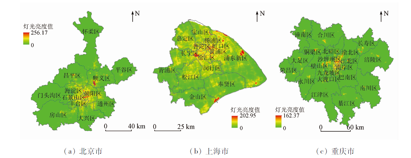
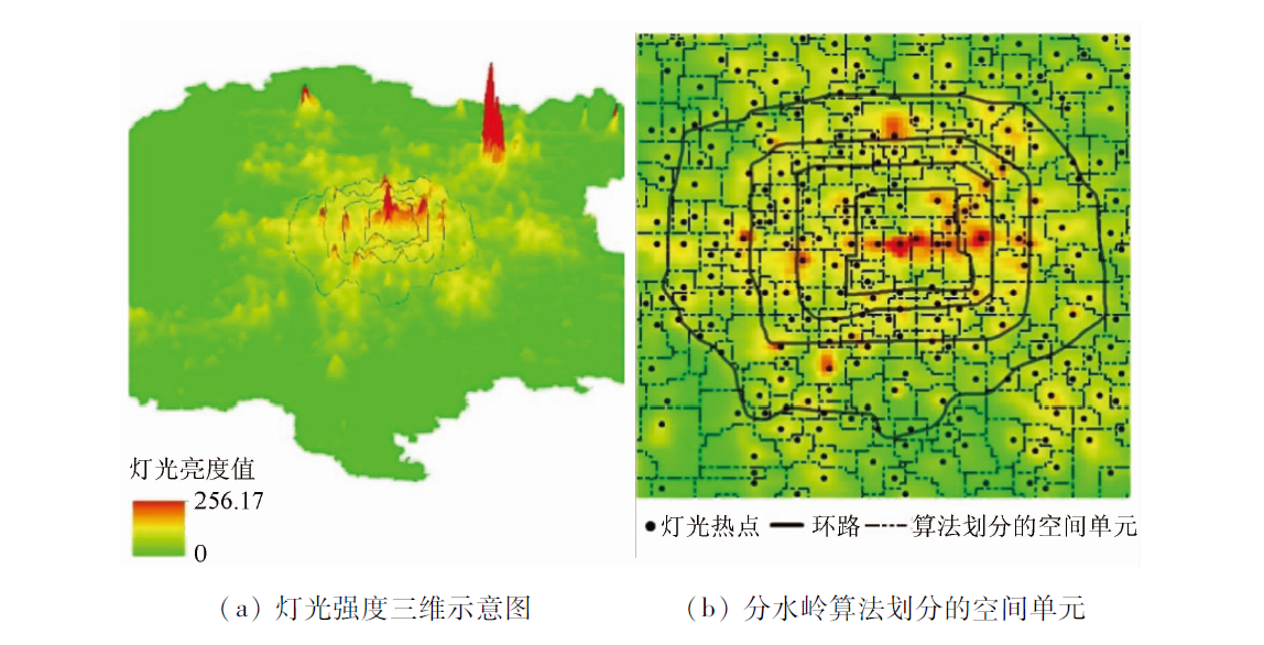
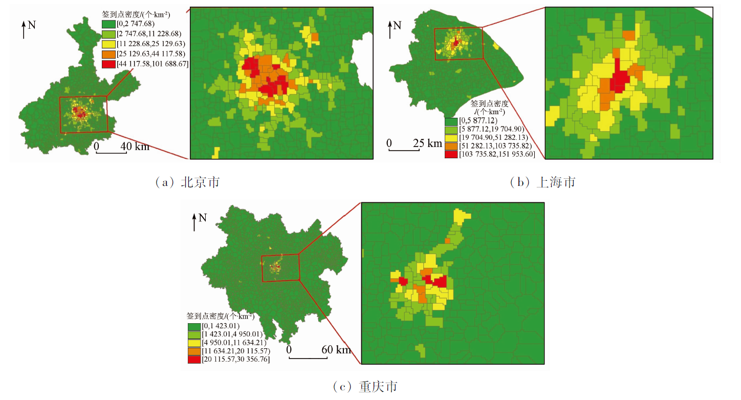
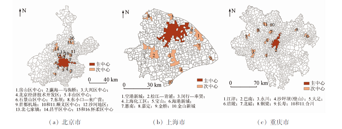
The emergence of geographic big data provides a new data source for the study of urban spatial structures. Identifying the polycentric urban structure based on geographic big data is currently a hot research topic in academic communities. This study proposed a method for identifying the polycentric urban structure based on multi-source geographic big data. First, the spatial units in the study area were determined using a region segmentation algorithm based on drainage divides. Then, the urban centers and subcenters were identified using the two-stage algorithm for urban center identification. Finally, the identification results were compared and verified. The results of this study are as follows: ① The region segmentation algorithm based on drainage divides can effectively identify the spatial features of nighttime light data, and the basic spatial units acquired using this algorithm can be used to identify urban spatial structures; ② The urban centers identified based on the Weibo (MicroBlog) check-in data, which can effectively reflect urban human activities, and the two-stage algorithm for urban center identification are roughly consistent with those set in the urban planning. Therefore, the method proposed in this study is of great significance for expanding the application scope of geographic big data and enriching the existing research methods for urban spatial structures.
Huang D, Liu Z, Zhao X. Monocentric or Polycentric? The urban spatial structure of employment in Beijing[J]. Sustainability, 2015, 7(9):11632-11656.
doi: 10.3390/su70911632
[2]
He C, Chen T, Mao X, et al. Economic transition,urbanization and population redistribution in China[J]. Habitat International, 2016, 51:39-47.
doi: 10.1016/j.habitatint.2015.10.006
[3]
Kong X, Xu Z, Shen G, et al. Urban traffic congestion estimation and prediction based on floating car trajectory data[J]. Future Generation Computer Systems, 2016, 61(c):97-107.
[4]
Zheng S, Kahn M E. A new era of pollution progress in urban China[J]. Journal of Economic Perspectives, 2017, 31(1):71-92.
doi: 10.1257/jep.31.1.71
[5]
Wang D, Kwan M P. Selected studies on urban development issues in China:Introduction[J]. Urban Geography, 2017, 38(3):360-362.
doi: 10.1080/02723638.2016.1158037
Sun T S. Employment decentralization and evolution of employment spatial structure amid suburbanization:An empirical study on Beijing metropolitan area[J]. City Planning Review, 2015, 39(10):9-15.
[8]
Lou G, Chen Q, He K, et al. Using nighttime light data and POI big data to detect the urban centers of Hangzhou[J]. Remote Sensing, 2019, 11(15):1821.
doi: 10.3390/rs11151821
[9]
Cai J, Huang B, Song Y. Using multi-source geospatial big data to identify the structure of polycentric cities[J]. Remote Sensing of Environment, 2017, 202:210-221.
doi: 10.1016/j.rse.2017.06.039
[10]
Li Y. Towards concentration and decentralization:The evolution of urban spatial structure of Chinese cities,2001—2016[J]. Computers,Environment and Urban Systems, 2020, 80:101425.
doi: 10.1016/j.compenvurbsys.2019.101425
[11]
Sun T. A longitudinal study of changes in intra-metropolitan employment concentration in Beijing:Decentralisation,reconcentration and polycentrification[J]. Urban Studies, 2020, 57(5):848-765.
[12]
Sun T, Lyu Y. Employment centers and polycentric spatial development in Chinese cities:A multi-scale analysis[J]. Cities, 2020, 99:102617.
doi: 10.1016/j.cities.2020.102617
Sun T S, Wang L L, Li G P. Distributions of population and employment and evolution of spatial structures in the Beijing metropolitan area[J]. Acta Geographica Sinica, 2012, 67(6):829-840.
doi: 10.11821/xb201206010
[14]
Deng Y, Liu J, Liu Y, et al. Detecting urban polycentric structure from POI data[J]. ISPRS International Journal of Geo-Information, 2019, 8(6):283.
doi: 10.3390/ijgi8060283
[15]
Li J, Long Y, Dang A. Live-work-play centers of Chinese cities:Identification and temporal evolution with emerging data[J]. Computers Environment and Urban Systems, 2018, 71(1):58-66.
doi: 10.1016/j.compenvurbsys.2018.04.002
[16]
Liu X, Yan X, Wang W, et al. Characterizing the polycentric spatial structure of Beijing metropolitan region using carpooling big data[J]. Cities, 2021, 109(1):103040.
doi: 10.1016/j.cities.2020.103040
[17]
Long Y, Song Y, Chen L. Identifying subcenters with a nonparametric method and ubiquitous point-of-interest data:A case study of 284 Chinese cities[J]. Environment and Planning B Urban Analytics and City Science, 2022, 49(1):58-75.
doi: 10.1177/2399808321996705
[18]
Lyu Y, Lan Z, Kan C, et al. Polycentric urban development and its determinants in China:A geospatial big data perspective[J]. Geographical Analysis, 2020, 53(3):520-542.
doi: 10.1111/gean.v53.3
[19]
Liu X, Wang J. The geography of Weibo[J]. Environment and Planning A, 2015, 47(6):1231-1234.
doi: 10.1177/0308518X15594912
[20]
Ma T, Yin Z, Zhou A. Delineating spatial patterns in human settlements using VIIRS nighttime light data:A watershed-based partition approach[J]. Remote Sensing, 2018, 10(3):465.
doi: 10.3390/rs10030465
[21]
Muniz I, Garcia-Lopez M A, Galindo A. The effect of employment sub-centres on population density in Barcelona[J]. Urban Studies, 2008, 45(3):627-649.
doi: 10.1177/0042098007087338
[22]
Giuliano G, Small K A. Subcenters in the Los Angeles region[J]. University of California Transportation Center Working Papers, 1990, 21(2):163-182.
[23]
Baumont C, Ertur C, Gallo J L. Spatial analysis of employment and population density:The case of the agglomeration of Dijon 1999[J]. Geographical Analysis, 2004, 36(2):146-176.
doi: 10.1111/gean.2004.36.issue-2
[24]
Guillain R, Gallo J L, Baumont C, et al. Agglomeration and dispersion of economic activities in Paris and its surroundings:An exploratory spatial data analysis[J]. Environment and Planning B:Urban Analytics and City Science, 2007, 37(6):961-981.
[25]
Vasanen A. Functional polycentricity:Examining metropolitan spatial structure through the connectivity of urban sub-centres[J]. Urban Studies, 2012, 49(16):3627-3644.
doi: 10.1177/0042098012447000
[26]
Asikhia M O, Nkeki N F. Polycentric employment growth and the commuting behaviour in Benin metropolitan region,Nigeria[J]. Journal of Geography and Geology, 2013, 5(2):1-17.
[27]
Mcdonald J, Prather P. Suburban employment centres:The case of Chicago[J]. Urban Studies, 1994, 31(2):201-218.
doi: 10.1080/00420989420080201
[28]
McMillen D P. Nonparametric employment subcenter identification[J]. Journal of Urban economics, 2001, 50(3):448-473.
doi: 10.1006/juec.2001.2228
[29]
Redfearn C L. The topography of metropolitan employment:Identifying centers of employment in a polycentric urban area[J]. Journal of Urban Economics, 2007, 61(3):519-541.
doi: 10.1016/j.jue.2006.08.009
[30]
Lyu Y, Zhou L, Yao G, et al. Detecting the true urban polycentric pattern of Chinese cities in morphological dimensions:A multiscale analysis based on geospatial big data[J]. Cities, 2021, 116(17):103298.
doi: 10.1016/j.cities.2021.103298
[31]
Hajrasouliha A H, Hamidi S. The typology of the American metropo-lis:Monocentricity,polycentricity,or generalized dispersion[J]. Urban Geography, 2016, 38(3):1-25.
[32]
Lv Y, Zheng X, Zhou L, et al. Decentralization and polycentricity:Spatial changes of employment in Beijing metropolitan area,China[J]. Sustainability, 2017, 9(10):1880.
doi: 10.3390/su9101880
[33]
Hu L, Sun T, Wang L. Evolving urban spatial structure and commuting patterns:A case study of Beijing,China[J]. Transportation Research Part D Transport and Environment, 2018, 59:11-22.
doi: 10.1016/j.trd.2017.12.007
[34]
Lee B. “Edge” or “edgeless” cities? Urban spatial structure in U.S.Metropolitan areas,1980 to 2000[J]. Journal of Regional Science, 2007, 47(3):479-515.
doi: 10.1111/jors.2007.47.issue-3
[35]
Krehl A. Urban subcentres in German city regions:Identification,understanding,comparison[J]. Papers in Regional Science, 2016, 2(1):289-307.
[36]
Amindarbari R, Sevtsuk A. Measuring growth and change in metropolitan form[J]. Sciences, 2012, 104(17):7301-7306.
Wei X H, Sun B D. Formation mechanism of employment subcenters in metropolitan areas:The case of Shanghai in comparison to Beijing[J]. Urban Planning Forum, 2014(5):65-71.
Jiang L, Wu F L. Guangzhou non-registered population spatial distribution and impact on poloycentricity spatial structure[J]. Modern Urban Research, 2014(5):15-21.
Zeng H H, Meng X C, Li G C. Spatial structure of employment and its evolution in Shenzhen City:2001—2004[J]. Human Geography, 2010, 25(3):34-40.
[40]
Pereira R H M, Nadalin V, Monasterio L, et al. Urban centrality:A simple index[J]. Geographical Analysis, 2013, 45(1):77-89.
doi: 10.1111/gean.12002
[41]
Garcia-López M-À, Muñiz I. Employment decentralisation:Polycentricity or scatteration? The case of Barcelona[J]. Urban Studies, 2010, 47(14):3035-3056.
doi: 10.1177/0042098009360229
[42]
Nam K, Kim B H S. The effect of spatial structure and dynamic externalities on local growth in Seoul metropolitan area[J]. Urban Policy and Research, 2016, 35(2):1-15.
doi: 10.1080/08111146.2017.1283751
 2023, Vol. 35
  ), 于新伟1, 杨朔1, 郑新奇2(