Population spatialization based on geographically weighted regression model considering spatial stability of parameters
XIAO Dongsheng1,2,3(), LIAN Hong1,2()
1. School of Civil Engineering and Surveying and Mapping, Southwest Petroleum University, Chengdu 610500, China 2. Disaster Prevention and Emergency Research Center of Mapping and Remote Sensing Geographic Information of Southwest Petroleum University, Chengdu 610500, China 3. Public Security and Emergency Research Institute, Sichuan Normal University, Chengdu 610068, China
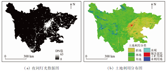
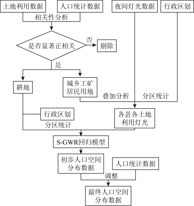
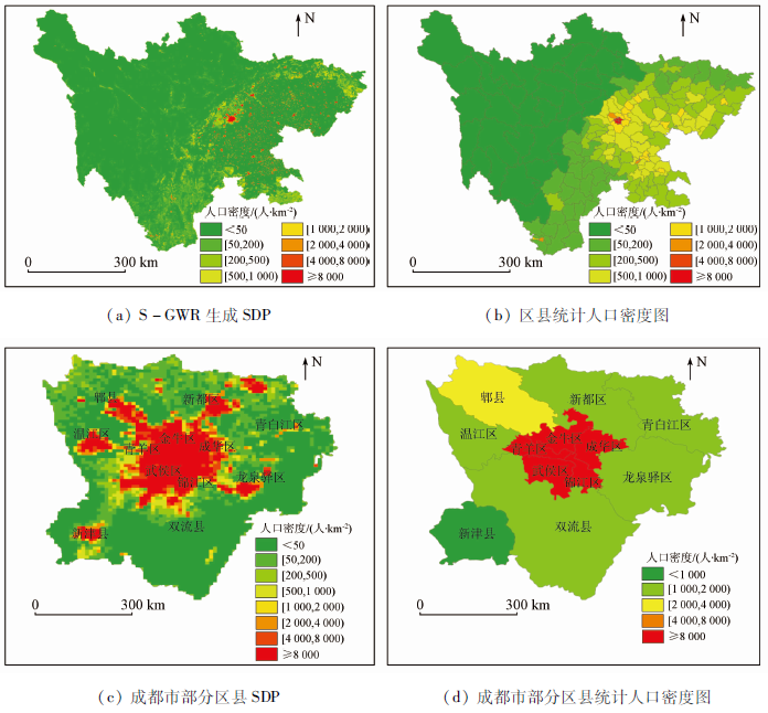
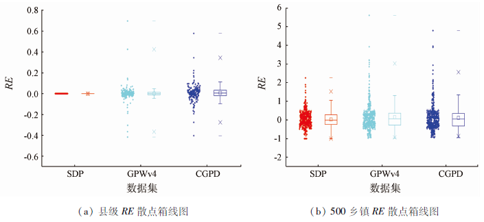
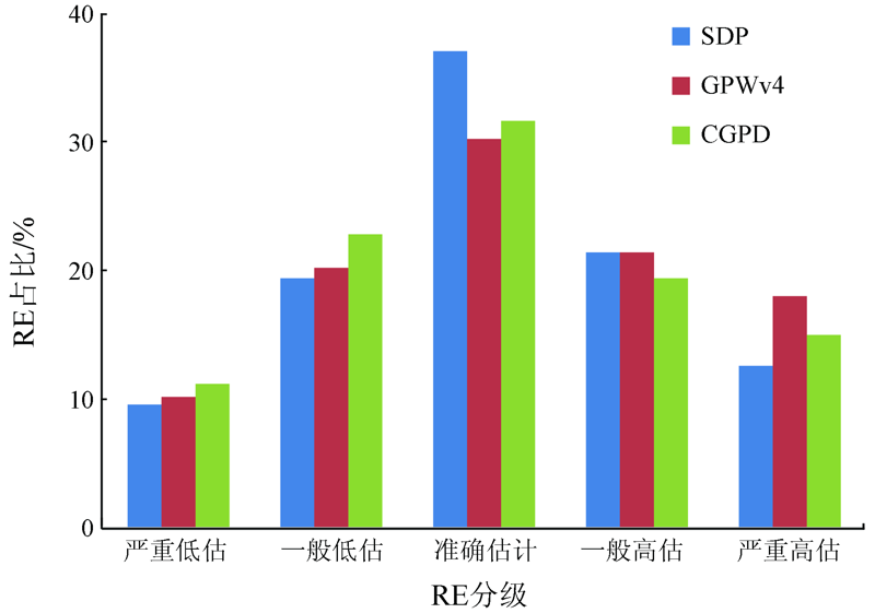
The theories on population spatialization tend to be mature in recent years. However, the spatial stability of the variables and parameters used in population spatialization modeling has been scarcely focused on. With the land use data, night-time light data, and demographic data as the data sources, this study proposed a novel precise population spatialization method based on a semi-parametric geographically weighted regression model (S-GWR). Then a permanent population spatialization model on a county scale was built using the method proposed in this study and then was verified using the Sichuan Province as the study area. In this study, the spatial stability of parameters and variables were obtained using the S-GWR model while the characteristics of the variables were analyzed, in order to improve the accuracy of population estimation. Finally, the population spatial distribution map (SDP) with a resolution of 1 km of Sichuan Province in 2010 was formed. The results show that the coefficient of determination coefficient of the S-GWR model was 0.903, which is higher than that of traditional regression models and indicates better fitting effects. The S-GWR model was verified using two commonly used population datasets, and the verification results are as follows. At a county level, the overall average error of the study area and the relative error of each district and county in the SDP all approximated to 0, and thus the SDP was more precise than the other two datasets. At a township level, the mean relative error, mean absolute error, and root mean square error of SDP were 34.54%, 5 715.703, and 12 085.932, respectively, which were all lower than those of the other two datasets. Meanwhile, the SDP showed more favorable dispersion effects than the other datasets. Furthermore, the number of the towns whose population was accurately estimated was 185 in the SDP, which was higher than that in the other two datasets. Therefore, the accuracy of population spatialization can be improved by considering the spatial stability of parameters.
肖东升, 练洪. 顾及参数空间平稳性的地理加权人口空间化研究[J]. 自然资源遥感, 2021, 33(3): 164-172.
XIAO Dongsheng, LIAN Hong. Population spatialization based on geographically weighted regression model considering spatial stability of parameters. Remote Sensing for Natural Resources, 2021, 33(3): 164-172.
Tan M, Liu K, Liu L, et al. Spatialization of 30 m grid population in Pearl River Delta based on stochastic forest model[J]. Progress in Geography, 2017, 36(10):1304-1312.
Xiao D S, Yang S. A survey of population spatial distribution based on night light data[J]. Remote Sensing for Land and Resources, 2019, 31(3):10-19.doi: 10.6046/gtzyyg.2019.03.02.
doi: 10.6046/gtzyyg.2019.03.02
[4]
Elvidge C D, Baugh K E, Dietz J B, et al. Radiance calibration of DMSP-OLS low-light imaging data of human settlements[J]. Remote Sensing Enviroment, 1999, 68,77-88.
doi: 10.1016/S0034-4257(98)00098-4
[5]
Zhang Q L, Seto K C. Mapping urbanization dynamics at regional and global scales using multi-temporal DMSP/OLS nighttime light data[J]. Remote Sensing of Environment, 2011, 115(9):2320-2329.
doi: 10.1016/j.rse.2011.04.032
Chen Q, Hou X Y, Wu L. Comparison of population spatialization models based on land use data and DMSP/OLS data respectively:A case study in the efficient ecological economic zone of the Yellow River Delta[J]. Human Geography, 2014, 29(5):94-100.
Yang X C, Gao D W, Ding M J, et al. Spatialization of population statistics based on multi-source remote sensing data and DEM:A case study of Zhejiang Province[J]. Resources and Environment in the Yangtze Basin, 2013, 22(6):729-734.
Zhao L L, Meng F, Ma C X. Spatial distribution pattern evolution of Wuhan population based on multi-source remote sensing data[J]. Areal Research and Development, 2016, 35(3):165-169.
Hu Y F, Zhao G H, Zhang Q L. Population spatialization in Sichuan and Chongqing based on night lighting and LUC data[J]. Journal of Geo-Information Science, 2018, 20(1):68-78.
Huang J, Yan Q W, Liu Y W. Spatial analysis of population data in Jiangsu Province based on DMSP/OLS and land use[J]. Resources and Environment in the Yangtze Basin, 2015, 24(5):735-741.
Ding W X, Zhao W, Zuo D L, et al. Population distribution simulation based on coupling of land use classification model and gravity model:A case study of Wuhan population data[J]. Geodesy and Geodynamics, 2011, 31(s1):127-131.
[12]
Fotheringham A S, Brunsdon C. Local forms of spatial analysis[J]. Geographical Analysis, 2010, 31,340-358.
doi: 10.1111/gean.1999.31.issue-4
Wang K J, Cai H Y, Yang X H. Application of multivariate statistical regression and geographically weighted regression in the study of multi-scale population spatialization[J]. Progress in Geography, 2016, 35(12):1494-1505.
Zhang J C, Wang Y H. Simulation of rural population spatial distribution based on land use classification:A case study of Hefeng County,Hubei Province[J]. Journal of Geo-Information Science, 2014, 16(3):435-442.
Chen Q, Hou X Y. Integrating land use data and night light data to optimize population spatialization model[J]. Journal of Geo-Information Science, 2015, 17(11):1370-1377.
Wang M M, Wang J L. Spatialization of township population data in Shandong Province based on night lighting and land use data[J]. Journal of Geo-Information Science, 2019, 21(5):699-709.
[17]
Dong N, Yang X H, Cai H Y. Research progress and perspective on the spatialization of population data[J]. Journal of Geo-Information Science, 2016, 18:1295-1304.
[18]
四川统计局. 四川统计年鉴[M]. 北京: 中国统计出版社, 2010.
Statistical Bureau of Sichuan Province. Sichuan statistical yearbook[M]. Beijing: China Statistics Press, 2010.
Yang J R, Li Y Q, Wang R. Sichuan and Chongqing region:Strategic fulcrum of the Belt and Road initiatives and Yangtze River economic zone[J]. Reform of Economic System, 2015(4):58-64.
Liu J Y, Ning J, Kuang W H, et al. Spatial and temporal patterns and new characteristics of land use change in China from 2010 to 2015[J]. Acta Geographica Sinica, 2018, 73(5):789-802.
 2021, Vol. 33
  ), 练洪1,2(