Spatial heterogeneity of the correlation between water quality and land use in the Chenjiang River basin, Chenzhou City
ZHOU Shisong1(), TANG Yuqi1,2(), CHENG Yuxiang1, ZOU Bin1,2, FENG Huihui1,2
1. School of Geosciences and Info-Physics, Central South University, Changsha 410083, China 2. Key Laboratory of Metallogenic Prediction of Nonferrous Metals and Geological Environment Monitoring (Central South University), Ministry of Education, Changsha 410083, China
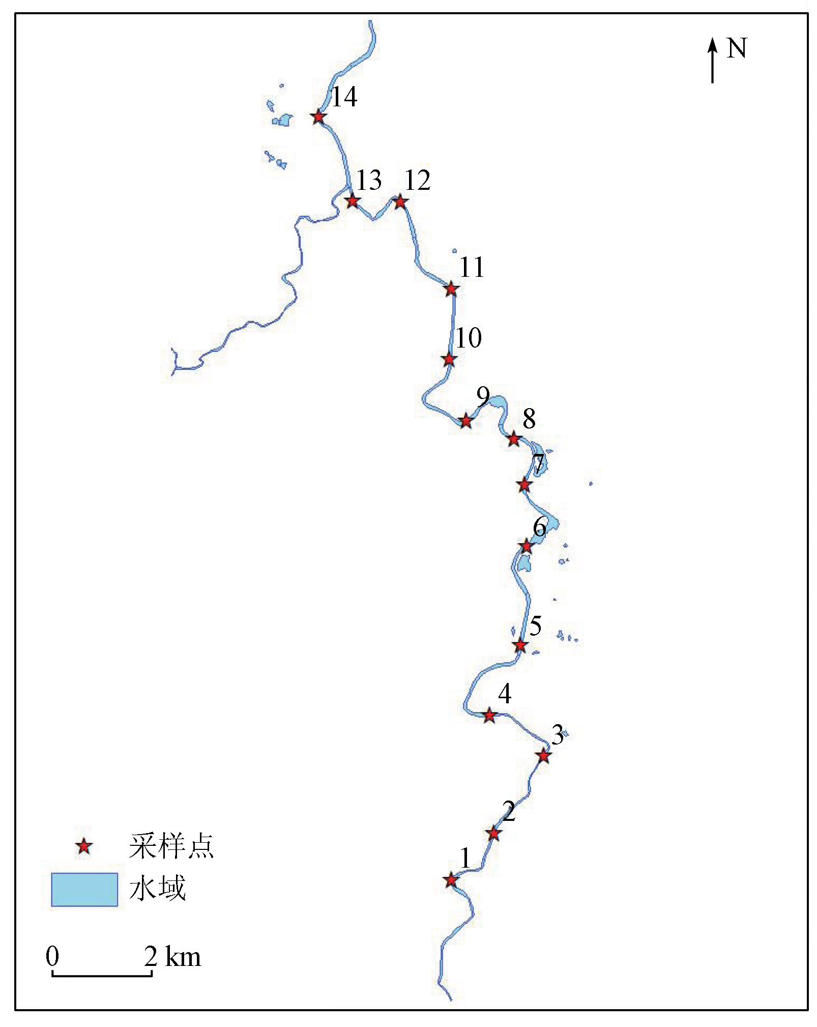
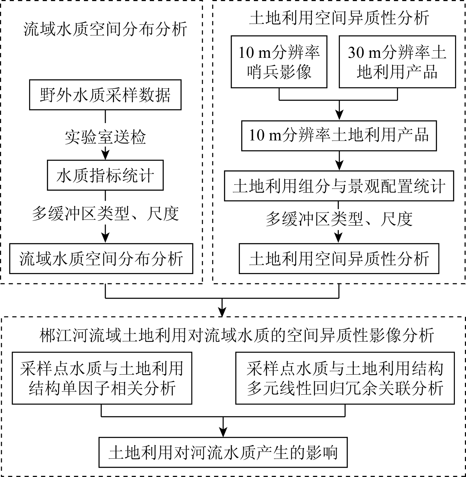
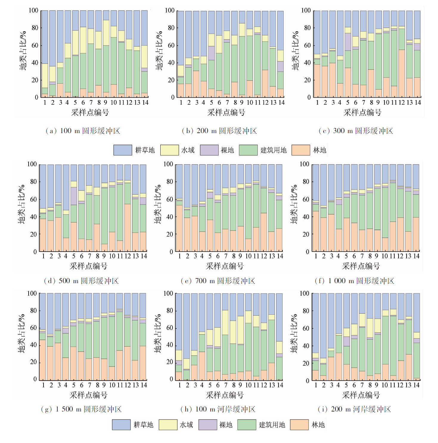
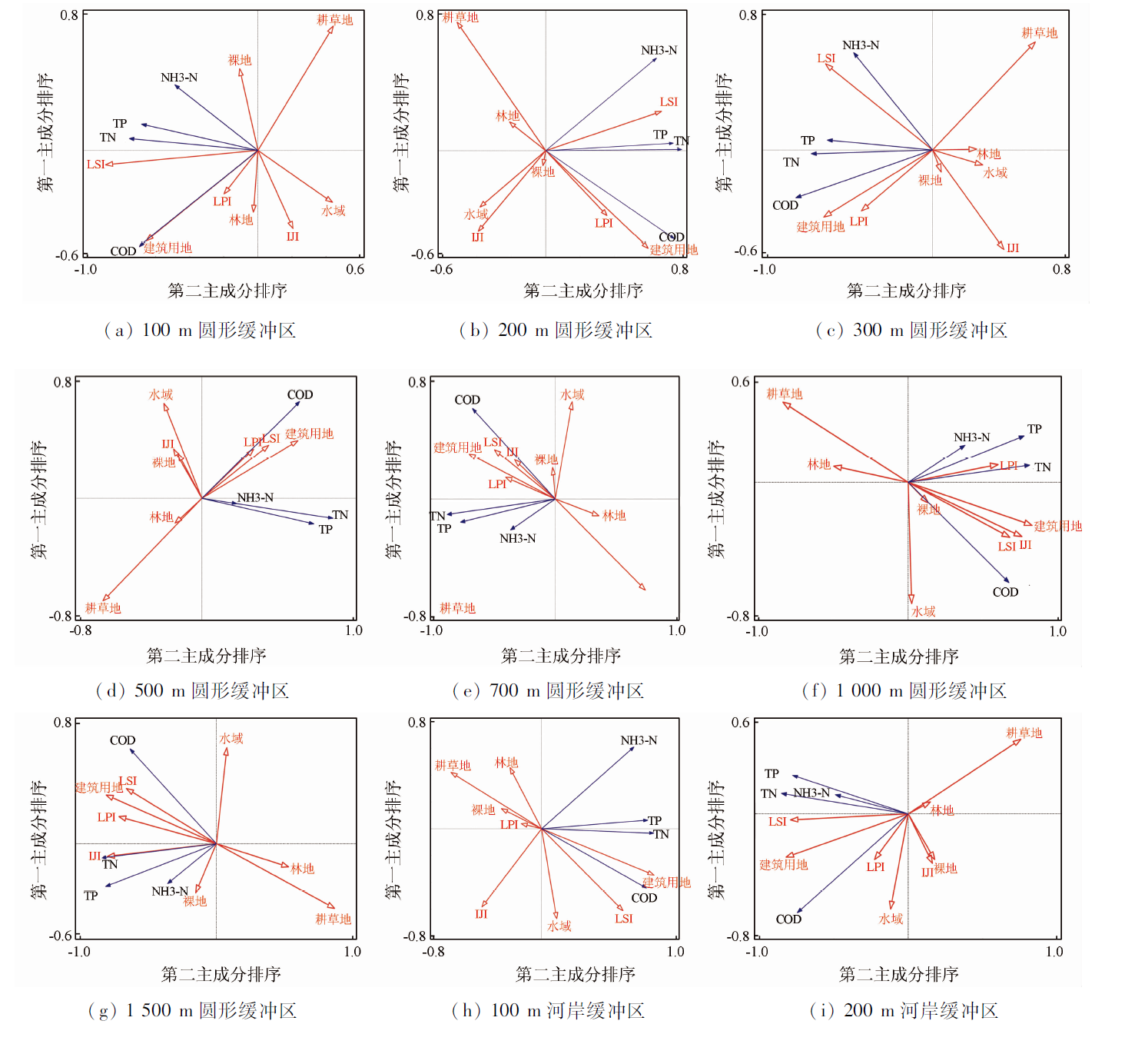
This study investigated the spatial heterogeneity of the correlation between water quality and land use in the Chenjiang River basin of Chenzhou City using the water quality and high-resolution remote sensing data of the river basin in September 2021. Based on the division of river basin buffer zones by different types and scales, this study calculated land use components and their landscape configurations, such as the shape, size, and distribution of patches. Then, this study analyzed the spatial heterogeneity effect of regional land use on water quality through single-factor and multi-factor correlation analyses. The results are as follows: ① In the single-factor correlation analysis of spatial heterogeneity between water quality and land use, circular buffer zones showed higher universality than riparian buffer zones, which played a complementary role in analyzing the effect of built-up land occupation on water quality parameters. In the multi-factor correlation analysis of spatial heterogeneity, the land use presented generally higher interpretation rates for water quality parameters in riparian buffer zones than in circular buffer zones, with the maximum total interpretation rate of land use for water quality parameters in circular buffer zones occurring on a scale of a radius of 700 m. ② Different land use components had different effects on water quality. The proportions of cultivated land, grassland, forest land, and water areas correlated positively with water quality, while those of building land and bare land correlated negatively with water quality. Among them, cultivated land, grassland, and building land had the most significant effects on water quality. Land use planning should consider the influence of land use components and reasonably allocate the proportions of artificial and natural features. ③ Different landscape configurations had different effects on water quality. The landscape shape index (LSI) and the largest patch index (LPI), which reflect the shape and size of patches, had negative effects on water quality. Furthermore, the interspersion and juxtaposition index (IJI), which reflects the distribution of patches, correlated negatively with the ammonia nitrogen (NH3-N) content in water bodies on a small scale. Land use planning should consider the rationality of landscape configurations. For example, it is necessary to control the sizes of dominant land patches in the buffer zones. This study identified the buffer zone size that influences water quality the most and the land use components and landscape configurations that can explain the water quality of the Chenjiang River the best. Therefore, this study provides a basis for selecting scientific control measures for the deterioration of water quality in the Chenjiang River, showing certain significance for water environment protection.
周石松, 汤玉奇, 程宇翔, 邹滨, 冯徽徽. 郴州市郴江河流域水质与土地利用关联的空间异质性分析[J]. 自然资源遥感, 2023, 35(3): 230-240.
ZHOU Shisong, TANG Yuqi, CHENG Yuxiang, ZOU Bin, FENG Huihui. Spatial heterogeneity of the correlation between water quality and land use in the Chenjiang River basin, Chenzhou City. Remote Sensing for Natural Resources, 2023, 35(3): 230-240.
Franco E G. The global risks report 2020[J/OL]. World Economic Forum (2020-01-28)[2022-05-09]. https://www.weforum.org/reports/the-global-risks-report-2020.
[2]
HHC S. Landscape ecological approach to the relationships of land use patterns in watersheds to water quality characteristics[J]. Landscape and Urban Planning, 2009, 12(6):956-963.
Lyu Z Q, Qing X Y, Ren Y F, et al. Effects of land use pattern on water quality in mountainous city:A case study of Chongqing City[J]. Journal of Lake Sciences, 2016, 28(2):319-327.
doi: 10.18307/2016.0211
Liu L J, Li X Y, He X Y. Advances in the studying of the relationship between landscape pattern and river water quality at the watershed scale[J]. Acta Ecologica Sinica, 2011, 31(19):5460-5465.
Wang J, Li P, Gao H D, et al. A preliminary study on the relationship between land use/landscape index and water quality in the upper reaches of Danjiang River[J]. Research of Soil and Water Conservation, 2018, 25(6):383-389.
[6]
Mitchell M G E, Bennett E M, Gonzalez A. Linking landscape connectivity and ecosystem service provision:Current knowledge and research gaps[J]. Ecosystems, 2013, 16(5):894-908.
doi: 10.1007/s10021-013-9647-2
[7]
张以晖. 黄浦江河岸带土地利用变迁及其水质响应关系研究[D]. 上海: 华东师范大学, 2015.
Zhang Y H. Study on land use change and water quality response relationship in the bank zone of Huangpu River[D]. Shanghai: East China Normal University, 2015.
Zhao P, Xia B C, Qin J Q, et al. Multivariate correlation analysis between watershed landscape pattern and river water quality[J]. Acta Ecologica Sinica, 2012, 32(8):2331-2341.
doi: 10.5846/stxb
Zhang Z M, Du J L, Cheng D C, et al. Effects of land use and landscape pattern characteristics on surface seasonal water quality in typical networked river networks:A case study of Liyang City,Jiangsu Province[J]. Journal of Lake Science, 2022, 34(5):1524-1539.
[10]
Tu J. Spatially varying relationships between land use and water quality across an urbanization gradient explored by geographically weighted regression[J]. Applied Geography, 2011, 31(1):376-392.
doi: 10.1016/j.apgeog.2010.08.001
Li Y L, Xu Z X, Li Y F. A preliminary analysis of the relationship between multi-scale land use/landscape pattern and water quality response in Huntai River basin[J]. Earth and Environment, 2012, 40(4):573-583.
Lu J, Liu Y F, Huang H H, et al. Correlation analysis between land use structure and river water quality in Taiping Lake basin,Huangshan City[J]. Fudan Journal (Natural Science Edition), 2014, 53(6):731-736,746.
Jiao S, Yang N, Peng K, et al. Effects of land landscape pattern on river water quality in Shuishui basin[J]. Geographical Research, 2014, 33(12):2263-2274.
[14]
Li S, Xia X, Tan X, et al. Effects of catchment and riparian landscape setting on water chemistry and seasonal evolution of water quality in the upper Han River basin,China[J]. PLoS One, 2013, 8(1):e53163.
doi: 10.1371/journal.pone.0053163
Wang Y K, Cheng R H, Zeng P, et al. Spatial differentiation of water quality in river network in Shanghai and its response to land use in the riparian zone[J]. Journal of Ecology and Rural Enviroment, 2019, 35(7):925-932.
Cai H, He Z W, An Y L, et al. Response of Chishui River water quality to land use in the basin based on remote sensing and GIS[J]. Resources and Environment of Yangtze River Basin, 2015, 24(2):286-291.
Huang J L, Li Q S, Hong H S, et al. Preliminary correlation analysis of land use/landscape pattern-water quality in Jiulongjiang River basin[J]. Environmental Science, 2011, 32(1):64-72.
Luo Z L, Huang H. Research on sustainable development evaluation of Chenzhou City in the Red Triangle area:Ecological footprint method[J]. Journal of Hunan Agricultural University (Social Science Edition), 2004(2):33-37.
Zhu G H, Sun L, Liao X Y, et al. Characteristics and risk assessment of heavy metal and PAHs composite pollution in industrial site in Chenzhou[J]. Geographical Research, 2012, 31(5):831-839.
Xu H X. Study on comprehensive treatment measures for heavy metal pollution in mining area of Suxian District,Chenzhou City,Hunan Province[D]. Yangling: Northwest A&F University, 2014.
[21]
蒲泽生, 黄军, 李平学. 为了郴州新世纪的明天[J]. 城乡建设, 2002(5):17.
Pu Z S, Huang J, Li P X. For the tomorrow of Chenzhou’s new century[J]. Urban and Rural Construction, 2002(5):17.
Xu Q L, Lan G H. Water quality evaluation and protection countermeasures of major rivers in Chenzhou City[J]. Green Science and Technology, 2015(5):184-186.
State Environmental Protection Administration. GB 3838—2002 surface water environmental quality standard[S]. Beijing: China Standards Publishing House, 2002.
[25]
黄玉瑶. 内陆水域污染生态学[M]. 北京: 科学出版社, 2001.
Huang Y Y. Pollution ecology of inland waters[M]. Beijing: Science Press, 2001.
[26]
Ding J, Jiang Y, Liu Q, et al. Influences of the land use pattern on water quality in low-order streams of the Dongjiang River basin,China:A multi-scale analysis[J]. Science of the Total Environment, 2016,551-552:205-216.
[27]
Li S Y, Gu S, Tan X, et al. Water quality in the upper Han River basin,China:The impacts of land use/land cover in riparian buffer zone[J]. Hazard Mater, 2009(165):317-324.
[28]
Maa D, Db B, Kh C, et al. The impact of urban patterns on aquatic ecosystems:An empirical analysis in Puget lowland sub-basins[J]. Landscape and Urban Planning, 2007, 80(4):345-361.
doi: 10.1016/j.landurbplan.2006.08.001
[29]
董小俊. 南方红壤丘陵区森林景观格局分析和优化研究[D]. 北京: 首都师范大学, 2014.
Dong X J. Analysis and optimization of forest landscape pattern in red soil hilly area of southern China[D]. Beijing: Capital Normal University, 2014.
Fang N, Liu L L, You Q H, et al. Effects of different scales of land use patterns on water quality in Poyang Lake wetlands[J]. Environmental Science, 2019, 40(12):5348-5357.
Zhu H B, He L J. Study on the applicable conditions for the consistency test of normal distribution and the like by single-sample K-S test in SPSS[J]. Journal of Capital University of Physical Education, 2009, 21(4):466-470.
[32]
焦欢. 渠溪河流域土地利用及格局对河流水质影响研究[D]. 重庆: 重庆工商大学, 2016.
Jiao H. Study on the impact of land use and pattern on river water quality in Quxi River basin[D]. Chongqing: Chongqing Technology and Business University, 2016.
Zhou J J, Xiang J, Wang L Y, et al. Relationship between landscape pattern and river water chemistry characteristics of Binggou River basin in the eastern Qilian Mountains[J]. Chinese Journal of Ecolo-gy, 2019, 38(12):3779-3788.
Hu L, Li S Y. Effects of land use structure and landscape patterns at different spatial scales on water quality in Longchuan River basin[J]. Journal of Ecology and Environment, 2021, 30(7):1470-1481.
[35]
Guo Q H, Ma K M, Yang L, et al. Testing a dynamic complex hypothesis in the analysis of land use impact on lake water quality[J]. Water Resources Management, 2010, 24(7):1313-1332.
doi: 10.1007/s11269-009-9498-y
[36]
Xu Q, Wang P, Shu W, et al. Influence of landscape structures on river water quality at multiple spatial scales:A case study of the Yuan River watershed,China[J]. Ecological Indicators, 2021, 121:107226.
doi: 10.1016/j.ecolind.2020.107226
Ji D Q, Wen Y, Wei J B, et al. Correlation analysis between landscape spatial characteristics and river water quality in Liuxi River basin[J]. Acta Ecologica Sinica, 2015, 35(2):246-253.
[38]
Song M, Jiang Y, Liu Q, et al. Catchment versus riparian buffers:Which land use spatial scales have the greatest ability to explain water quality changes in a typical temperate watershed?[J]. Water, 2021, 13(13):1758.
doi: 10.3390/w13131758
 2023, Vol. 35
  ), 汤玉奇1,2(