MaxEnt-based multi-class classification of land use in remote sensing image interpretation
XIONG Dongyang1,2,3(), ZHANG Lin2,4, LI Guoqing2,4()
1. The Research Center of Soil and Water Conservation and Ecological Environment, Chinese Academy of Sciences and Ministry of Education, Yangling 712100, China 2. Institute of Soil and Water Conservation, Chinese Academy of Sciences and Ministry of Water Resources, Yangling 712100, China 3. University of Chinese Academy of Sciences, Beijing 100049, China 4. State Key Laboratory of Soil Erosion and Dryland Farming on the Loess Plateau, Northwest A&F University, Yangling 712100, China
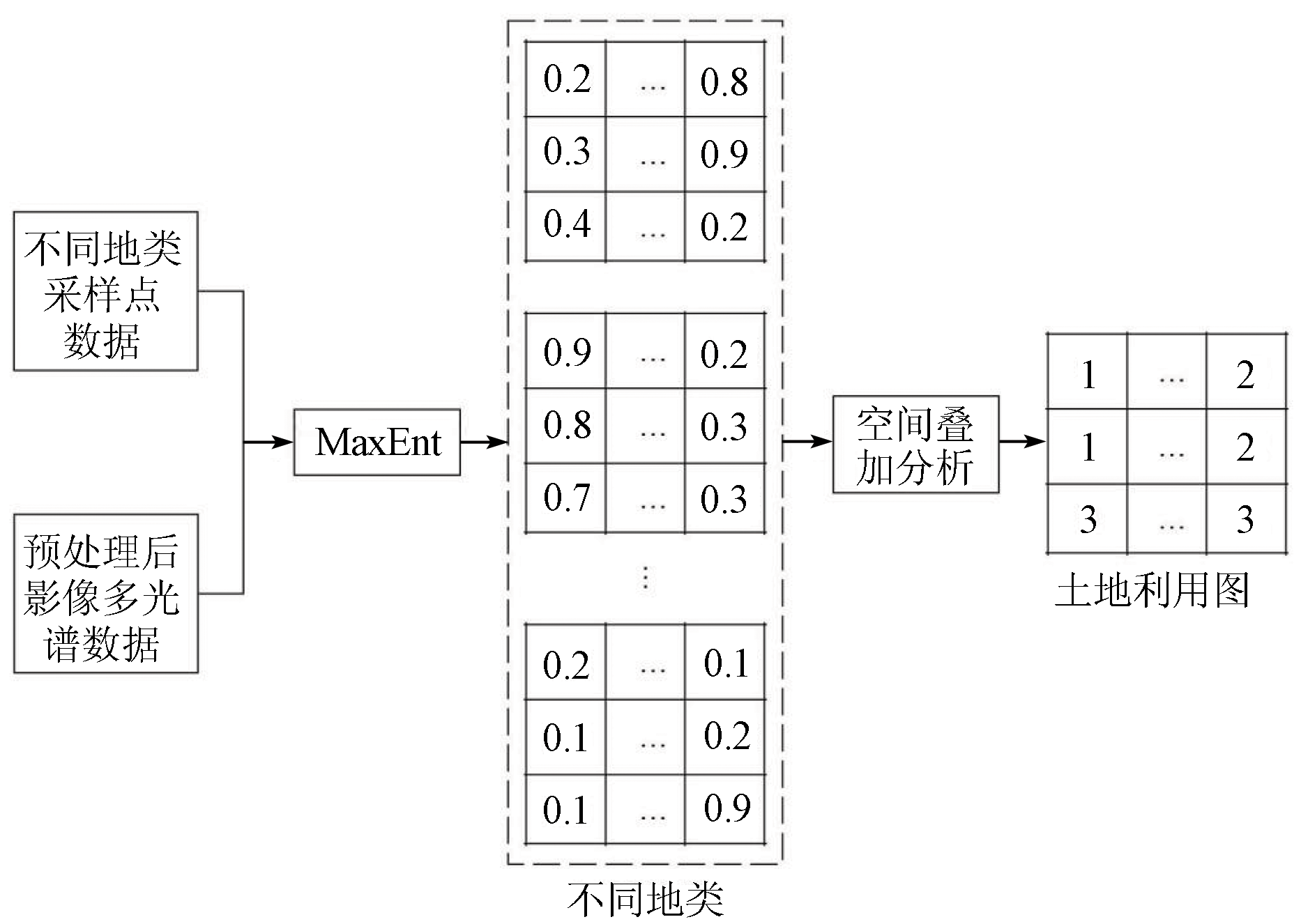
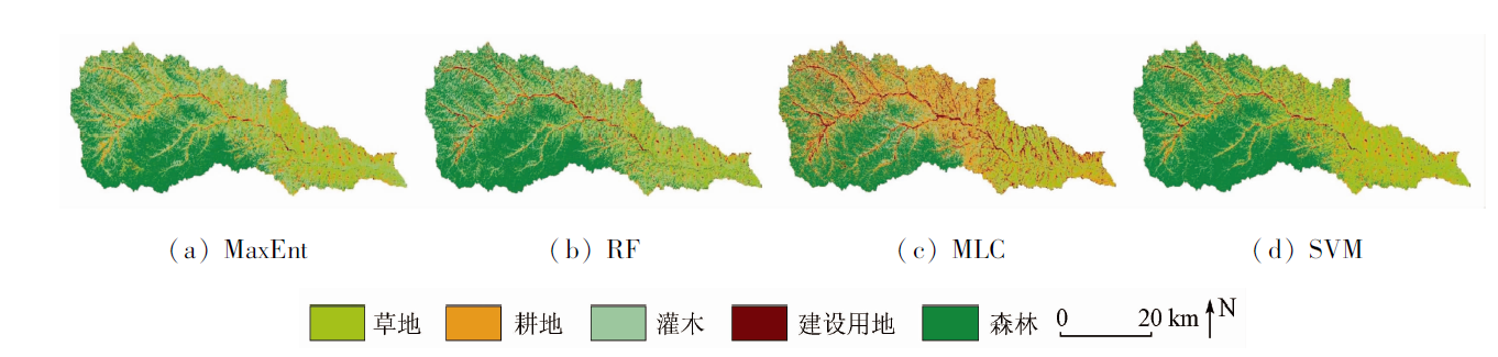
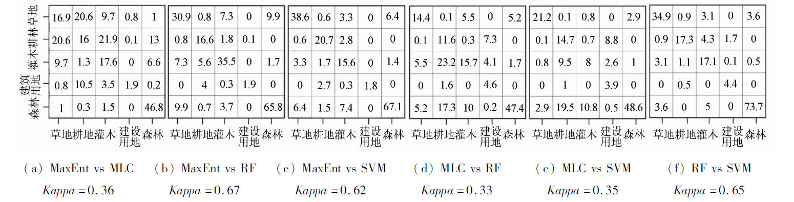
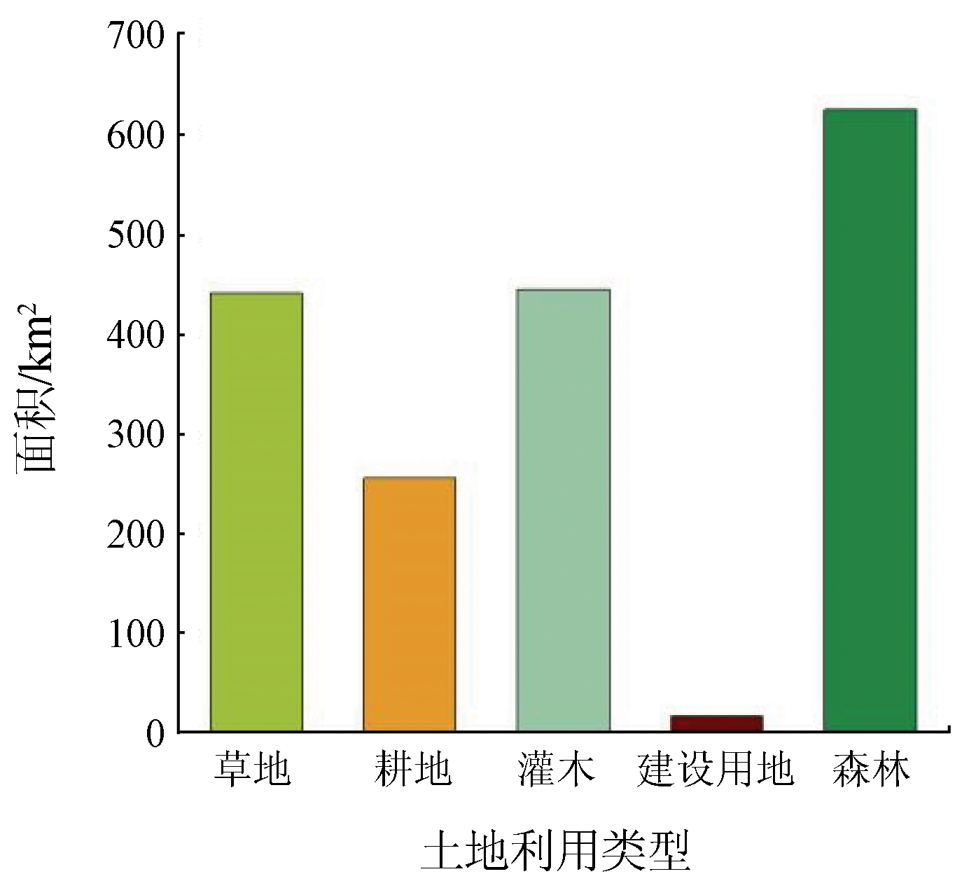
The one-class classification (OCC) of land use in image interpretation is a hot research topic of remote sensing. Many novel algorithms of OCC were introduced and developed. The maximum entropy model (MaxEnt)-the most promising OCC algorithm as evaluated-is widely used in the OCC study of land use. However, it is unclear about the applicability of these algorithms (including MaxEnt) in multi-class classification (MCC) of land use. Thus, this study established a procedure for MaxEnt-based land-use MCC in remote sensing image interpretation and applied the procedure to the land-use MCC of the Yunyan River basin. The overall classification effect of MaxEnt and the performance of MaxEnt in the prediction of various land were evaluated using overall classification accuracy, Kappa coefficient, sensitivity, and specificity. Moreover, the Kappa coefficient was also used to evaluate the consistency between MaxEnt and random forest (RF), maximum likelihood classification (MLC), and support vector machine (SVM) in the prediction of land use maps. The results are as follows: ① MaxEnt showed the best classification effect, with overall classification accuracy of 84% and a Kappa coefficient of 0.8; ② MaxEnt showed no worst performance in any land type, and even performed the best in some land types; ③ MaxEnt showed high classification consistency with RF and SVM, and the consistency evaluation of the land use maps obtained using the three algorithms yielded Kappa coefficients of greater than 0.6; ④ Compared with the other the three algorithms, MLC yielded a significantly different land use map, with a Kappa coefficient of less than 0.4. This result indicates that MLC is not applicable to the interpretation of land use of the study area. The procedure established in this study only depends on the occurrence probability of land use rather than the threshold selected. As a result, the OCC algorithms represented by MaxEnt have great potential for application to the land-use MCC in remote sensing image interpretation. In addition, the introduction of parallel computing into large-scale land use interpretation will help improve the efficiency of solving MCC problems using MaxEnt.
Shu M, Du S H. Forty years’ progress and challenges of remote sensing in national land survey[J]. Journal of Geo-Information Science, 2022, 24(4):597-616.
[4]
Xu L, Herold M, Tsendbazar N E, et al. Time series analysis for global land cover change monitoring:A comparison across sensors[J]. Remote Sensing of Environment, 2022, 271:112905.
doi: 10.1016/j.rse.2022.112905
[5]
赵英时. 遥感应用分析原理与方法[M]. 北京: 科学出版社, 2003.
Zhao Y S. Principles and methods of remote sensing for applied anaysis[M]. Beijing: Science Press, 2003.
[6]
Lu D, Weng Q. A survey of image classification methods and techniques for improving classification performance[J]. International Journal of Remote Sensing, 2007, 28(5):823-870.
doi: 10.1080/01431160600746456
[7]
Li W K, Guo Q H. A maximum entropy approach to one-class classification of remote sensing imagery[J]. International Journal of Remote Sensing, 2010, 31(7-8):2227-2235.
doi: 10.1080/01431161003702245
[8]
Shahzad N, Ding X, Abbas S. A comparative assessment of machine learning models for landslide susceptibility mapping in the rugged terrain of northern Pakistan[J]. Applied Sciences, 2022, 12(5):2280-2302.
doi: 10.3390/app12052280
[9]
Arabameri A, Asadi N O, Saha S, et al. Novel ensemble approaches of machine learning techniques in modeling the gully erosion susceptibility[J]. Remote Sensing, 2020, 12(11):1890-1918.
doi: 10.3390/rs12111890
[10]
Fernández I C, Morales N S. One-class land-cover classification using MaxEnt:The effect of modelling parameterization on classification accuracy[J]. PeerJ, 2019, 7:e7016.
doi: 10.7717/peerj.7016
[11]
Lin J Y, Liu X P, Li K, et al. A maximum entropy method to extract urban land by combining MODIS reflectance,MODIS NDVI,and DMSP-OLS data[J]. International Journal of Remote Sensing, 2014, 35(17-18):6708-6727.
doi: 10.1080/01431161.2014.960623
Chen Y B, Zheng Z H, Wu Z F, et al. Review and prospect of application of nighttime light remote sensing data[J]. Progress in Geo-graphy, 2019, 38(2):205-223.
Bai Q J, Song Z S, Wang H R, et al. Quantitative analysis of the impact of natural factors and human factors on hydrological system using the SWAT model:The Zhangweinan canal basin case[J]. Journal of Natural Resources, 2018, 33(9):1575-1587.
doi: 10.31497/zrzyxb.20170882
[14]
Arnold J G, Williams J R, Maidment D R. Continuous-time water and sediment-routing model for large basins[J]. Journal of Hydraulic Engineering, 1995, 121(2):171-183.
doi: 10.1061/(ASCE)0733-9429(1995)121:2(171)
[15]
李航. 统计学习方法[M]. 北京: 清华大学出版社, 2012.
Li H. Statistics learning method[M]. Beijing: Tsinghua University Press, 2012.
[16]
Jaynes E T. Information theory and statistical mechanics[J]. Physical Review, 1957, 106(4):620-630.
doi: 10.1103/PhysRev.106.620
[17]
Sanchez-Hernandez C, Boyd D S, Foody G M. One-class classification for mapping a specific land-cover class:SVDD classification of Fenland[J]. IEEE Transactions on Geoence and Remote Sensing, 2007, 45(4):1061-1073.
[18]
Phillips S J, Dudík M, Schapire R E. Maxent software for modeling species niches and distributions(Version 3.4.1)[EB/OL]. [2022-08-22]http://-biodiversityinformatics.amnh.org/open_source/maxent/.
Zhou K, Yang Y Q, Zhang Y N, et al. Review of land use classification methods based on optical remote sensing images[J]. Science Technology and Engineering, 2021, 21(32):13603-13613.
[20]
Belgiu M, Drăguţ L. Random forest in remote sensing:A review of applications and future directions[J]. ISPRS Journal of Photogrammetry and Remote Sensing, 2016, 114:24-31.
doi: 10.1016/j.isprsjprs.2016.01.011
[21]
Sisodia P S, Tiwari V, Kumar A. Analysis of supervised maximum likelihood classification for remote sensing image[C]// International Conference on Recent Advances and Innovations in Engineering (ICRAIE-2014).IEEE, 2014:1-4.
Luo J C, Wang Q M, Ma J H, et al. The EM-based maximum likelihood classifier for remotely sensed data[J]. Acta Geodaetica et Cartographica Sinica, 2002(3):234-239.
[23]
Otukei J R, Blaschke T. Land cover change assessment using decision trees,support vector machines and maximum likelihood classification algorithms[J]. International Journal of Applied Earth Observation and Geoinformation, 2010, 12:S27-S31.
doi: 10.1016/j.jag.2009.11.002
Zhang R, Ma J W. State of the art on remotely sensed data classification based on support vector machines[J]. Advances in Earth Science, 2009, 24(5):555-562.
doi: 10.11867/j.issn.1001-8166.2009.05.0555
[25]
Thomas N, Hanna M, Tim A, et al. Satellite:Handling and manipulating remote sensing data[EB/OL]. [2021-10-12]https://cran.r-project.org/web/packages/satellite/index.html.
Li G Q, Huang J H, Liu G, et al. A study of the landscape fragmentations of land cover structure based on Landsat8 remote sensing image:A case study of Mata watershed in Yanan,Shaanxi Province[J]. Remote Sensing for Land and Resources, 2020, 32(3):121-128.doi:10.6046/gtzyyg.2020.03.16.
doi: 10.6046/gtzyyg.2020.03.16
[27]
Artstein R, Poesio M. Inter-coder agreement for computational linguistics[J]. Computational Linguistics, 2008, 34(4):555-596.
doi: 10.1162/coli.07-034-R2
[28]
Cohen J. A coefficient of agreement for nominal scales[J]. Educational and psychological measurement, 1960, 20(1):37-46.
doi: 10.1177/001316446002000104
[29]
Mack B, Waske B. In-depth comparisons of MaxEnt,biased SVM and one-class SVM for one-class classification of remote sensing data[J]. Remote Sensing Letters, 2017, 8(3):290-299.
doi: 10.1080/2150704X.2016.1265689
Xu Z Y, Shen Z F, Li Y, et al. Classification of high-resolution remote sensing images based on enhanced Deep Lab algorithm and adaptive loss function[J]. National Remote Sensing Bulletin, 2022, 26(2):406-415.
doi: 10.11834/jrs.20209200
Wu L L, Li X Y, Mao D H, et al. Urban land use classification based on remote sensing and multi-source geographic data[J]. Remote Sensing for Natural Resources, 2022, 34(1):127-134.doi:10.6046/zrzyyg.2021061.
doi: 10.6046/zrzyyg.2021061
Wang Y N, Kong X B, Zhao C J, et al. Change of vegetation coverage in the Loess Plateau from 2000 to 2020 and its spatiotemporal pattern analysis[J]. Journal of Soil and Water Conservation, 2022, 36(3):130-137.
[33]
Li G Q, Huang J H, Guo H, et al. Projecting species loss and turnover under climate change for 111 Chinese tree species[J]. Forest Ecology and Management, 2020, 477:118488.
doi: 10.1016/j.foreco.2020.118488
[34]
Phillips S J, Anderson R P, Schapire R E. Maximum entropy modeling of species geographic distributions[J]. Ecological modelling, 2006, 190(3-4):231-259.
doi: 10.1016/j.ecolmodel.2005.03.026
[35]
Li W, Zhang W, Li Z, et al. A new method for surface water extraction using multi-temporal Landsat8 images based on maximum entropy model[J]. European Journal of Remote Sensing, 2022, 55(1):303-312.
doi: 10.1080/22797254.2022.2062054
[36]
Rapinel S, Hubert-Moy L. One-class classification of natural vegetation using remote sensing:A review[J]. Remote Sensing, 2021, 13(10):1892-1915.
doi: 10.3390/rs13101892
[37]
Norallahi M, Kaboli H S. Urban flood hazard mapping using machine learning modelings:GARP,RF,MaxEnt and NB[J]. Natural Hazards, 2021, 106(1):119-137.
doi: 10.1007/s11069-020-04453-3
Guan X F, Zeng Y M. Research progress and trends of parallel processing,analysis,and mining of big spatiotemporal data[J]. Progress in Geography, 2018, 37(10):1314-1327.
 2023, Vol. 35
  ), 张林2,4, 李国庆2,4(