Deformation monitoring and analysis of mining areas based on the DT-SDFPT combined time-series InSAR
YU Bing1,2,3,4(), WANG Bing1, LIU Guoxiang5, ZHANG Guo3, HU Yunliang1, HU Jinlong1
1. School of Civil Engineering and Geomatics, Southwest Petroleum University, Chengdu 610500, China 2. Institude of Petroleum and Natural Gas Spatial Information Engineering, Southwest Petroleum University, Chengdu 610500, China 3. State Key Laboratory of Information Engineering in Surveying, Mapping & Remote Sensing, Wuhan University, Wuhan 430079, China 4. State Key Laboratory of Geodesy and Earth’s Dynamics, Innovation Academy for Precision Measurement Science and Technology, Chinese Academy of Sciences, Wuhan 430077, China 5. Faculty of Geosciences and Environmental Engineering, Southwest Jiaotong University, Chengdu 611756, China
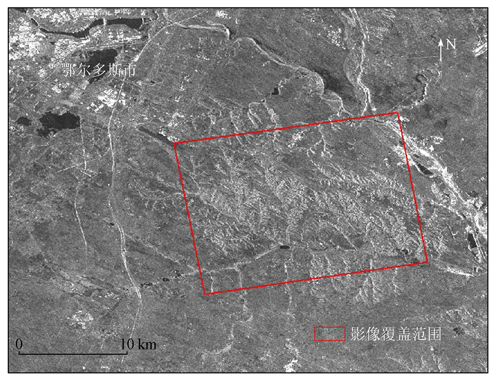
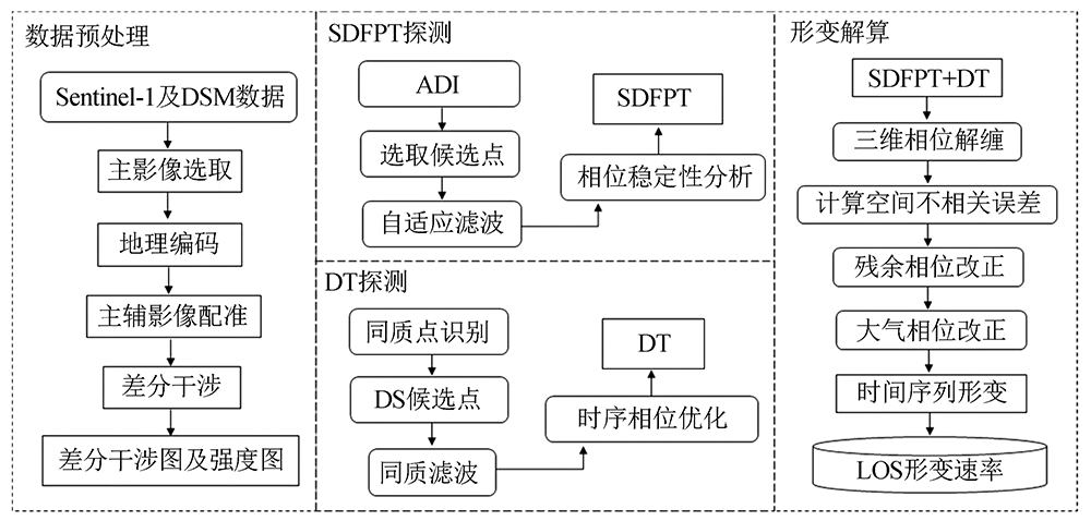
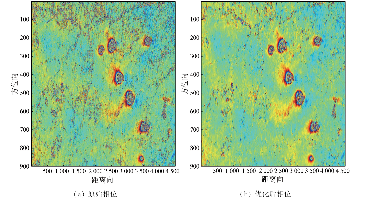
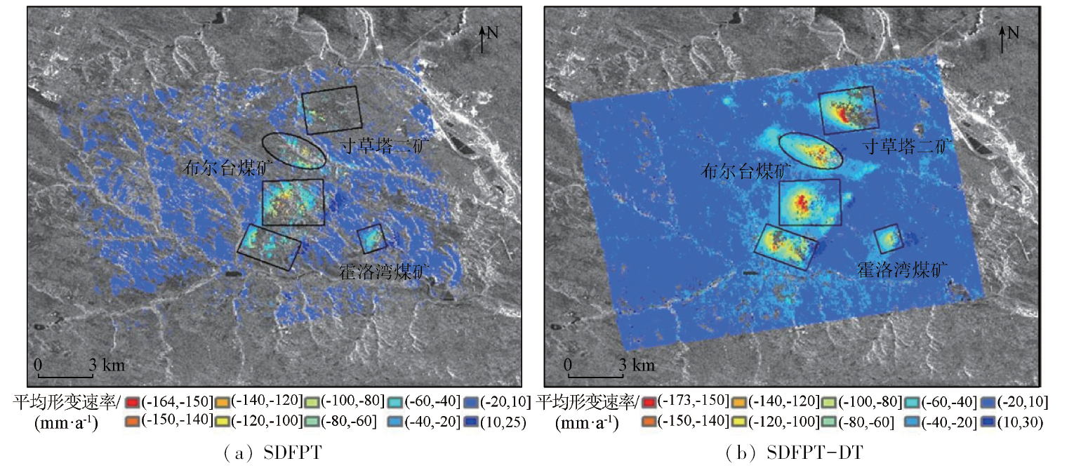
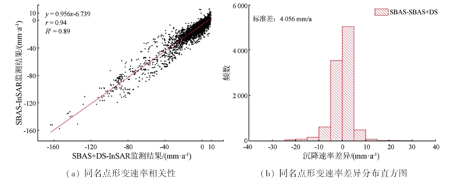
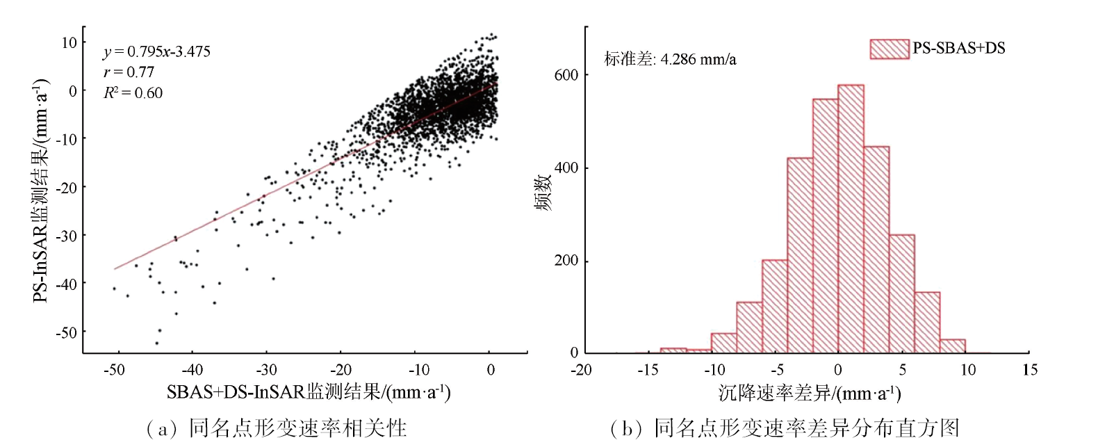
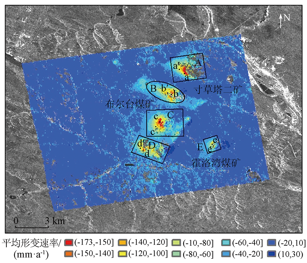
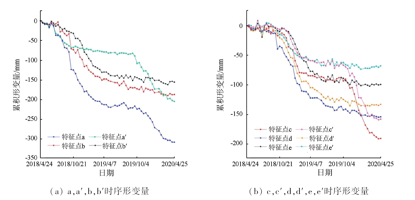
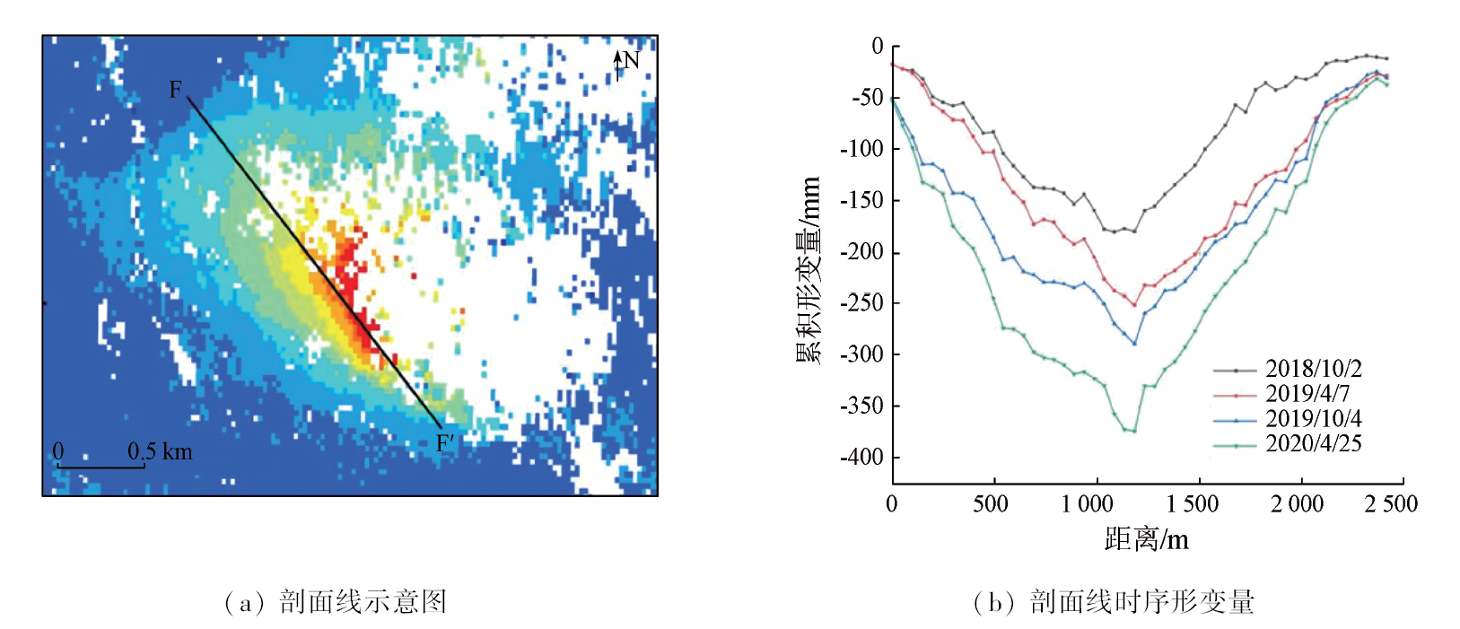
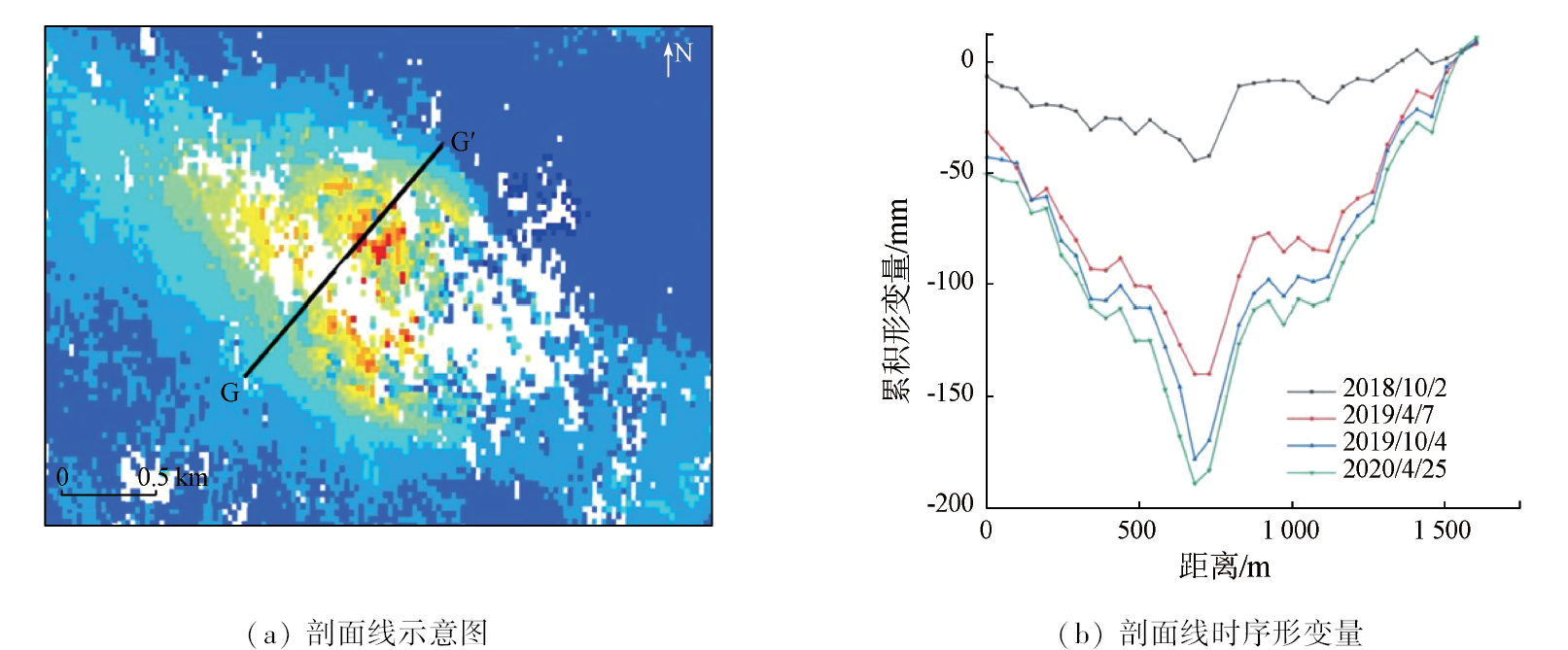
High-intensity coal mining leads to significant surface deformation and secondary geological disasters. Synthetic aperture Radar interferometry (InSAR), exhibiting high deformation monitoring capability, fails to detect enough target pixels in the mining core and surrounding low-coherence areas. This study intends to increase the density and coverage of deformation monitoring points in mining areas by combining distributed targets (DTs) and slowly-decorrelating filtered phase targets (SDFPTs). First, DT and SDFPT candidate pixels were selected using the fast statistically homogenous pixel selection (FaSHPS) method and the amplitude dispersion index method, respectively for phase optimization and stability analysis. Then, qualified DT and SDFPT pixels were screened out to constitute a fused pixel set, which was subjected to three-dimensional phase unwrapping, phase time series recovery, and spatio-temporal filtering. Consequently, the deformation time series and the annual average deformation rate were determined based on the fused pixel set. Finally, the method proposed in this study was applied to monitor the deformation in the Buertai coal mine using 60 scenes of Sentinel-1 images covering the coal mine from April 2018 to April 2020. The results reveal a significant increase in the density and coverage of deformation points through the integration of DT and SDFPT, thus allowing for the monitoring of higher levels of maximum deformation. Within the experimental area, five deformation cones were identified, with the maximum cumulative deformation amplitude reaching -309.76 mm. The influencing range of the deformations and the difference in the deformation amplitude of the time series in different years are closely related to mining activities.
于冰, 王冰, 刘国祥, 张过, 胡云亮, 胡金龙. 融合DT和SDFPT的时序InSAR矿区形变监测与分析[J]. 自然资源遥感, 2024, 36(1): 14-25.
YU Bing, WANG Bing, LIU Guoxiang, ZHANG Guo, HU Yunliang, HU Jinlong. Deformation monitoring and analysis of mining areas based on the DT-SDFPT combined time-series InSAR. Remote Sensing for Natural Resources, 2024, 36(1): 14-25.
Xu P, Yang J. Review of China’ energy industry in 2018 and outlook of 2019[J]. Oil Forum, 2019, 38(1):8-19.
[2]
何国清, 杨伦, 凌赓娣, 等. 矿山开采沉陷学[M]. 徐州: 中国矿业大学出版社,1991.
He G Q, Yang L, Liang G D, et al. Mining subsidence science[M]. Xuzhou: China University of Mining and Technology Press,1991.
[3]
Ferretti A, Prati C, Rocca F. Permanent scatterers in SAR interferometry[J]. IEEE Transactions on Geoscience and Remote Sensing, 2001, 39(1):8-20.
doi: 10.1109/36.898661
[4]
Berardino P, Fornaro G, Lanari R, et al. A new algorithm for surface deformation monitoring based on small baseline differential SAR interferograms[J]. IEEE Transactions on Geoscience and Remote Sensing, 2002, 40(11):2375-2383.
doi: 10.1109/TGRS.2002.803792
Li D R, Liao M S, Wang Y. Progress of permanent scatterer interferometry[J]. Geomatics and Information Science of Wuhan University, 2004, 29(8):664-668.
Li S S, Li Z W, Hu J, et al. Investigation of the seasonal oscillation of the permafrost over Qinghai-Tibet Plateau with SBAS-InSAR algorithm[J]. Chinese Journal of Geophysics, 2013, 56(5):1476-1486.
[7]
Chaussard E, Wdowinski S, Cabral-Cano E, et al. Land subsidence in central Mexico detected by ALOS InSAR time-series[J]. Remote Sensing of Environment, 2014, 140:94-106.
doi: 10.1016/j.rse.2013.08.038
[8]
Yu B, Liu G, Li Z, et al. Subsidence detection by TerraSAR-X interferometry on a network of natural persistent scatterers and artificial corner reflectors[J]. Computers & Geosciences, 2013, 58:126-136.
doi: 10.1016/j.cageo.2013.04.020
[9]
Ferretti A, Fumagalli A, Novali F, et al. A new algorithm for processing interferometric data-stacks:SqueeSAR[J]. IEEE Transactions on Geoscience & Remote Sensing, 2011, 49(9):3460-3470.
[10]
Dwivedi R, Narayan A B, Tiwari A, et al. Optimal estimation of interferometric phase for measuring surface deformation[J]. International Journal of Remote Sensing, 2017, 38(5):1339-1349.
doi: 10.1080/01431161.2017.1280627
Fan R Y, Jiao J, Gao S, et al. Comparison research of high coherent target selection based on InSAR time series analysis[J]. Journal of Geo-information Science, 2016, 18(6):805-814.
[12]
Parizzi A, Brcic R. Adaptive InSAR stack multilooking exploiting amplitude statistics:A comparison between different techniques and practical results[J]. IEEE Geoscience and Remote Sensing Letters, 2011, 8(3):441-445.
doi: 10.1109/LGRS.2010.2083631
Li G N, Tan Q L, Xie C, et al. Monitoring study on deformation along complex mountain railway based on DS-InSAR[J]. China Railway, 2019(2):59-65.
[14]
Ao M, Zhang L, Dong Y, et al. Characterizing the evolution life cycle of the Sunkoshi landslide in Nepal with multi-source SAR data[J]. Scientific Reports, 2020, 10:17988.
doi: 10.1038/s41598-020-75002-y
pmid: 33093621
Chen Y X, Jiang L M, Liang L L, et al. Monitoring permafrost deformation in the upstream Heihe River,Qilian Mountain by using multi-temporal Sentinel-1 InSAR dataset[J]. Chinese Journal of Geophysics, 2019, 62(7):2441-2454.
[16]
Goel K, Adam N. An advanced algorithm for deformation estimation in non-urban areas[J]. ISPRS Journal of Photogrammetry and Remote Sensing, 2012, 73:100-110.
doi: 10.1016/j.isprsjprs.2012.06.001
Jiang M, Ding X L, He X F, et al. FaSHPS-InSAR technique for distributed scatterers:A case study over the lost hills oil field,California[J]. Chinese Journal of Geophysics, 2016, 59(10):3592-3603.
Li D, Deng K Z, Gao X X, et al. Monitoring and analysis of surface subsidence in mining area based on SBAS-InSAR[J]. Geomatics and Information Science of Wuhan University, 2018, 43(10):1531-1537.
Hu S, Wu W H, Long S C, et al. Application of distributed scatterer in deformation monitoring of Hongqinghe coal mine[J]. Journal of Geodesy and Geodynamics, 2019, 39(12):1261-1264.
Li Y, Jiang J X, Du Y L, et al. Surface subsidence monitoring by time series InSAR integrating with distributed targets in mining region[J]. Journal of China University of Mining & Technology, 2020, 49(6):1199-1206,1232.
Li Z, Fan H D, Gao Y T, et al. DS-InSAR-based monitoring and analysis of a long time series of surface deformation in the fire area of the Wuda Coal field[J]. Remote Sensing for Natural Resources, 2022, 34(3):138-145.doi:10.6046/zrzyyg.2021245.
[22]
Zhang Z, Wang C, Tang Y, et al. Subsidence monitoring in coal area using time-series InSAR combining persistent scatterers and distributed scatterers[J]. International Journal of Applied Earth Observation and Geoinformation, 2015, 39:49-55.
doi: 10.1016/j.jag.2015.02.007
Jiang J X, Du Y L, Chen Y, et al. Monitoring and analysis of surface deformation in Peibei mining region based on DS-InSAR technique[J]. Bulletin of Surveying and Mapping, 2021(2):117-121.
doi: 10.13474/j.cnki.11-2246.2021.0056
Jia H H, Zhang H Q, Li K D, et al. Application of fusion distributed scatterer time-series InSAR technique in deformation survey of mining area[J]. Journal of Jilin University(Earth Science Edition), 2022, 52(1):202-213.
Zhu J J, Li Z W, Hu J. Research progress and methods of InSAR for deformation monitoring[J]. Acta Geodaetica et Cartographica Sinica, 2017, 46(10):1717-1733.
doi: 10.11947/j.AGCS.2017.20170350
[26]
Hooper A. A multi‐temporal InSAR method incorporating both persistent scatterer and small baseline approaches[J]. Geophysical Research Letters, 2008, 35(16):L16302.
Wei J C, Zhang H X, Bai Z C, et al. Integrated monitoring method of the mining subsidence of Shendong mining area based on D-InSAR and PS-InSAR technology[J]. Metal Mine, 2019(10):55-60.
[28]
Xu X, Ma C, Lian D, et al. Inversion and analysis of mining subsidence by integrating DInSAR,offset tracking,and PIM technology[J]. Journal of Sensors, 2020:4136837.
[29]
Ma C, Cheng X, Yang Y, et al. Investigation on mining subsidence based on multi-temporal InSAR and time-series analysis of the small baseline subset—Case study of working faces 22201-1/2 in Bu’ertai mine,Shendong coalfield,China[J]. Remote Sensing, 2016, 8(11):951.
doi: 10.3390/rs8110951
Cheng X Q, Ma C, Kang J R, et al. Simulation and time series analysis of mining subsidence by integrating DInSAR and PIM technology[J]. Journal of China University of Mining & Technology, 2018, 47(5):1141-1148.
Ma W, Ma C, Zhao P F, et al. Extraction of mining subsidence area based on coherence image of high resolution SAR[J]. Science of Surveying and Mapping, 2018, 47(5):115-120.
Zhou X L, Wu J L. Xin D L. Integrated innovation to design world No.One coal Mine-Buertai mine[J]. Coal Engineering, 2011(3):4-7.
[33]
Jiang M, Ding X, Tian X, et al. A hybrid method for optimization of the adaptive Goldstein filter[J]. ISPRS Journal of Photogrammetry and Remote Sensing, 2014, 98:29-43.
doi: 10.1016/j.isprsjprs.2014.09.012
Jiang M, Ding X L, Li Z W. Homogeneous pixel selection algorithm for multitemporal InSAR[J]. Chinese Journal of Geophysics, 2018, 61(12):4767-4776.
[35]
Zhang Z, Zeng Q, Jiao J. Deformations monitoring in complicated-surface areas by adaptive distributed Scatterer InSAR combined with land cover:Taking the Jiaju landslide in Danba,China as an example[J]. ISPRS Journal of Photogrammetry and Remote Sensing, 2022, 186:102-122.
doi: 10.1016/j.isprsjprs.2022.02.004
[36]
Hooper A, Zebker H A. Phase unwrapping in three dimensions with application to InSAR time series[J]. Journal of the Optical Society of America, 2007, 24(9):2737-47.
[37]
Hooper A, Segall P, Zebker H. Persistent scatterer interferometric synthetic aperture radar for crustal deformation analysis,with application to Volcán Alcedo,Galápagos[J]. Journal of Geophysical Research:Solid Earth, 2007, 112(B7).
 2024, Vol. 36
  ), 王冰1, 刘国祥5, 张过3, 胡云亮1, 胡金龙1