InSAR-based monitoring and analysis of Menyuan earthquake-induced surface deformations
JIN Xintian1,2,3(), WANG Shijie1,2,3,4(), ZHANG Lanjun1,2,3, GAO Xingyue1,2,3
1. Faculty of Geomatics, Lanzhou Jiaotong University, Lanzhou 730070, China 2. Nation-Local Joint Engineering Research Center of Technologies and Applications for National Geographic State Monitoring, Lanzhou 730070, China 3. Gansu Provincial Engineering Laboratory for National Geographic State Monitoring, Lanzhou 730070, China 4. Academician Expert Workstation of Gansu Dayu Jiuzhou Space Information Technology Co., Ltd., Lanzhou 730050, China
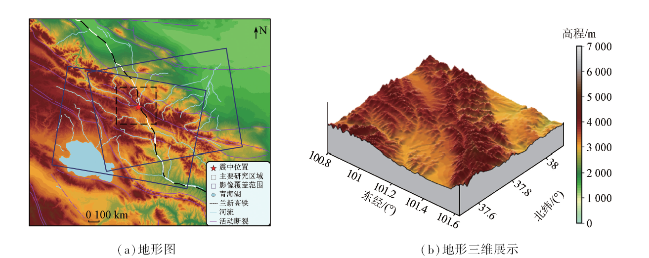
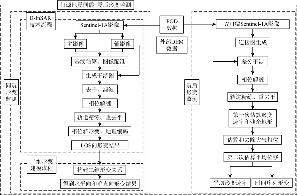
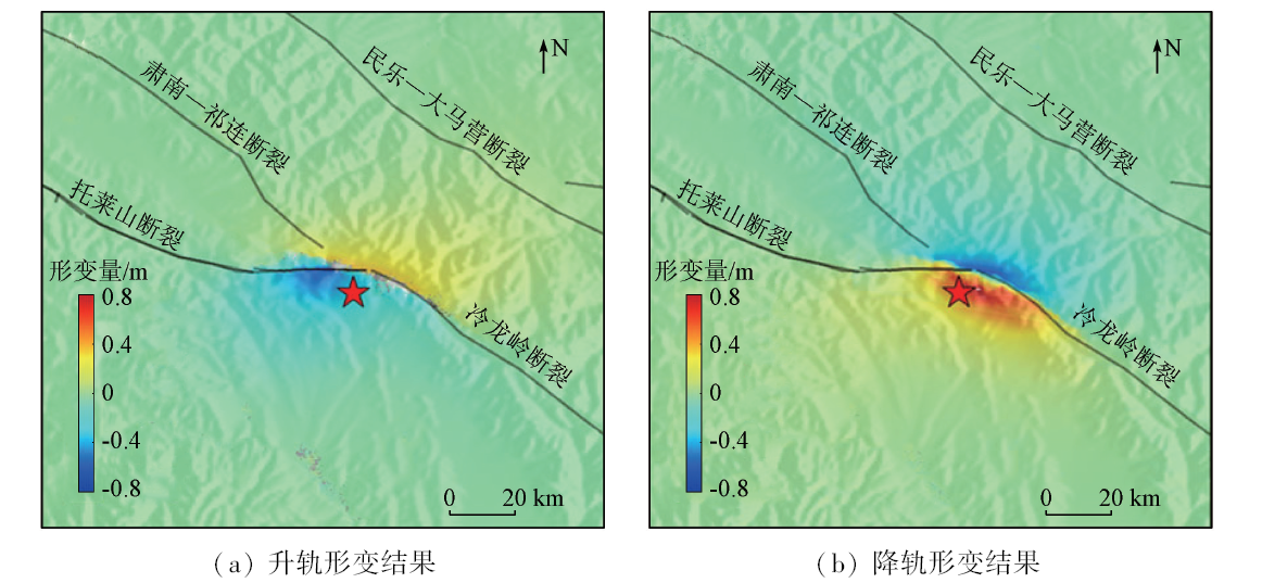
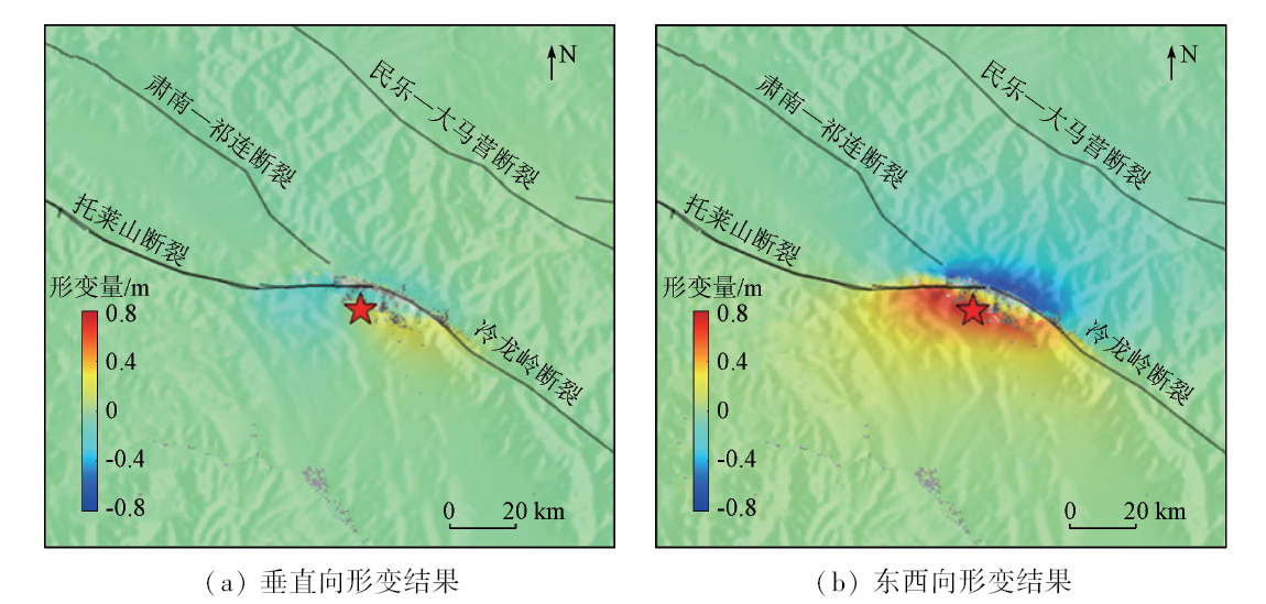
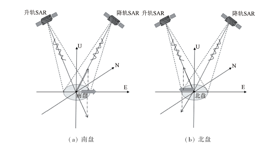
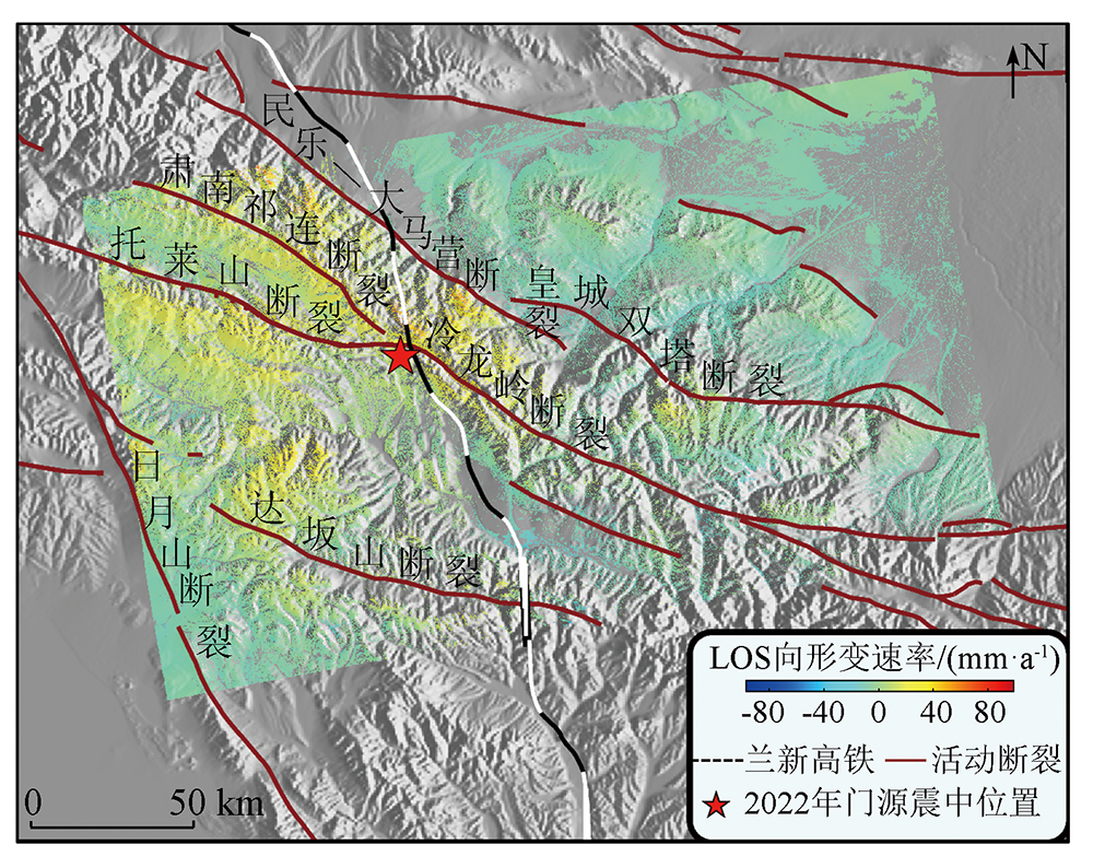
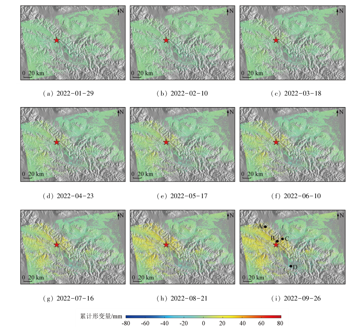
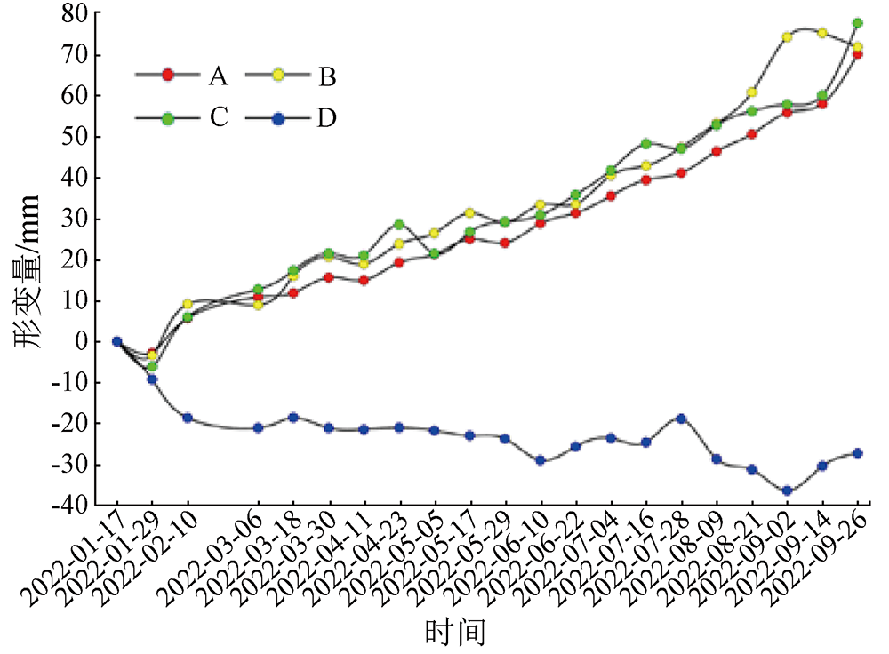
Earthquake-induced surface deformations are characterized by large scales and extensive coverage, and the resultant secondary geological disasters significantly impact local infrastructure and engineering construction. Investigating the surface deformations caused by the Menyuan earthquake is critical for understanding the seismic deformation movement and identifying potential geological disasters. This study obtained the coseismic deformation field of the Menyuan earthquake using the differential interferometric synthetic aperture Radar (D-InSAR) technique. Based on the geometric relationships between the ascending descending passes, this study extracted the two-dimensional information of surface deformations induced by the Menyuan earthquake. The results show that the coseismic deformations occurred primarily at the intersection of Lenglongling and Tuolaishan faults. The line-of-sight (LOS) surface deformations from ascending and descending passes exhibited uplift of 0.40 m and 0.80 m and subsidence of -0.65 m and -0.70 m, respectively. As indicated by the analysis of two-dimensional deformation based on the ascending and descending LOS surface deformation results, the maximum amplitude of vertical deformations dominated by subsidence was -0.32 m and the maximum amplitude of horizontal deformation dominated by eastward motion was 0.87 m, suggesting significant horizontal seismic deformations and fault activity dominated by left-lateral strike-slip process. Based on the 21 scenes of Sentinel-1A SAR images covering the study area taken from the ascending pass, this study extracted the information on the surface deformations after the Mengyuan earthquake using the small baseline subset-interferometric synthetic aperture Radar (SBAS-InSAR) technique, determining the LOS time series and average deformation rates. The results show that from January 17, 2022 to September 26, 2022, the study area experienced relatively stable overall deformations and significant local deformations. The fault activity was identified as the primary factor affecting the surface deformations, with a maximum average deformation rate of 53 mm/a and a maximum deformation amplitude of 77 mm. The results of this study will provide technical support for earthquake disaster mitigation, emergency management, and sustainable socio-economic development.
Dai L X, Xu Q, Fan X M, et al. A preliminary study on spatial distribution patterns of landslides triggered by Jiuzhaigou earthquake in Sichuan on August 8th,2017 and their susceptibility assessment[J]. Journal of Engineering Geology, 2017, 25(4):1151-1164.
Han Y S, Zhu Y Y, Kong Y P, et al. Distribution and development of secondary mountain hazards induced by the May 12,2008 Wenchuan earthquake in the ten most severely-afflicted counties[J]. The Chinese Journal of Geological Hazard and Control, 2010, 21(4):14-21.
Xu Q, Guo C, Dong X J. Application status and prospect of aerial remote sensing technology for geohazards[J]. Acta Geodaetica et Cartographica Sinica, 2022, 51(10):2020-2033.
doi: 10.11947/j.AGCS.2022.20220302
Wang D, Lai F B, Chen M Y, et al. Research on coseismic deformation in Ukraine River Valley of Tianshan Mountains based on InSAR technology[J]. Remote Sensing for Natural Resources, 2019,(1):187-194.doi:10.6046/gtzyyg.2019.01.25.
Dong J J, Mei Y, Li X, et al. SBAS-InSAR monitoring of slope safety and stability of high altitude dumps[J]. China Safety Science Journal, 2022, 32(1):92-101.
doi: 10.16265/j.cnki.issn1003-3033.2022.01.013
Li W L, Chen J Y, Lu H Y, et al. Emergency analysis of the Impact of the Luding Ms6.8 earthquake on Hailuogou glacier[J]. Geomatics and Information Science of Wuhan University, 2023, 48(1):47-57.
[7]
Zebker H A, Rosen P A, Goldstein R M, et al. On the derivation of coseismic displacement fields using differential Radar interferometry:The Landers earthquake[J]. Journal of Geophysical Research:Solid Earth, 1994, 99(b10):19617-19634.
[8]
Han B, Yang C, Li Z, et al. Coseismic and postseismic deformation of the 2016 Mw6.0 Petermann ranges earthquake from satellite Radar observations[J]. Advances in Space Research, 2022, 69(1):376-385.
doi: 10.1016/j.asr.2021.10.043
Li Z H, Zhu W, Yu C, et al. Interferometric synthetic aperture Radar for deformation mapping:Opportunities,challenges and the outlook[J]. Acta Geodaetica et Cartographica Sinica, 2022, 51(7):1485-1519.
Zhao Y H, Hou M J, Feng Q S, et al. Estimation of aboveground biomass in Menyuan grassland based on Landsat8 and random forest approach[J]. Acta Prataculturae Sinica, 2022, 31(7):1-14.
Jin X T, Wang S J, Jiang X, et al. Coseismic deformation and slip distribution of the Mw6.9 Menyuan,Qinghai earthquake revealed by Sentinel-1A SAR imagery[J]. Progress in Geophysics, 2022, 37(6):2267-2274.
Jiang C, Huo A D, Zhu X H, et al. Research status of loess hydraulic erosion-landslide-mudflow chain[J]. Journal of Natural Disasters, 2019, 28(1):38-43.
Dai K R, Zhuo G C, Xu Q, et al. Tracing the pre-failure two-dimensional surface displacements of Nanyu landslide,Gansu Province with Radar Interferometry[J]. Geomatics and Information Science of Wuhan University, 2019, 44(12):1778-1786,1796.
[15]
Wright T J, Parsons B E, Lu Z. Toward mapping surface deformation in three dimensions using InSAR[J]. Geophysical Research Letters, 2004, 31(1):169-178.
Yang W, He Y, Zhang L F, et al. InSAR monitoring of 3D surface deformation in Jinchuan mining area,Gansu Province[J]. Remote Sensing for Natural Resources, 2022, 34(1):177-188.doi:10.6046/zrzyyg.2021107.
Han S F, Chu H Y, Huang Z H, et al. Two-dimensional deformation acquisition of mining area using the ascending and descending orbit InSAR[J]. Journal of Lanzhou University (Natural Sciences), 2021, 57(1):47-53.
Gao H W, Shi X L, Chen C, et al. Two-dimensional surface deformation extraction of Yangbi earthquake in Yunnan[J]. Journal of Kunming University of Science and Technology (Natural Science Edition), 2022, 47(2):57-64.
Li Z H, Han B Q, Liu Z J, et al. Source parameters and slip distributions of the 2016 and 2022 Menyuan,Qinghai earthquakes constrained by InSAR observations[J]. Geomatics and Information Science of Wuhan University,2022, 47(6):887-897.
Yu Y, Li X, Sun Z, et al. Investigation on focal mechanism and coseismic slip distribution for Menyuan earthquake in 2022[J]. Journal of Geodesy and Geodynamics, 2023, 43(1):46-51.
Feng W P, He X H, Zhang Y P, et al. Seismic faults of the 2022 Mw6.6 Menyuan,Qinghai earthquake and their implication for the regional seismogenic structures[J]. Chinese Science Bulletin, 2023, 68(z1):254-270.
[22]
Gao F, Zielke O, Han Z, et al. Faulted landforms,slip-rate,and tectonic implications of the eastern Lenglongling fault,northeastern Tibetan Plateau[J]. Tectonophysics, 2022, 823:229195.
doi: 10.1016/j.tecto.2021.229195
Qu C Y, Shan X J, Zhang G H, et al. Study on the relationship between InSAR seismic deformation field and the nature of fault motion \ orientation and lift-track pattern[C]// 2014 China Joint Geoscience Annual Conference - Topic 25:InSAR Technology,Satellite Thermal Infrared and Crustal Motion Proceedings, 2014:58-59.
Wen S Y, Shan X J, Zhang Y F, et al. Three-dimensional co-seismic deformation of the Da Qaidam,Qinghai earthquakes derived from D-InSAR data and their source features[J]. Chinese Journal of Geophysics, 2016, 59(3):912-921.
Su Q, Yuan D Y, Xie H. Geomorphic features of the Shiyang River drainage basin and adjacent area in eastern Qilian Mountains and its insight into tectonic implications[J]. Geological Review, 2017, 63(1):7-20.
Zhao L Q, Sun X Y, Zhan Y, et al. The seismogenic model of the Menyuan MS6.9 earthquake on January 8,2022,Qinghai Province and segmented extensional characteristics of the Lenglongling fault[J]. Chinese Journal of Geophysics, 2022, 65(4):1536-1546.
[27]
Gaudemer Y, Tapponnier P, Meyer B, et al. Partitioning of crustal slip between linked,active faults in the eastern Qilian Shan,and evidence for a major seismic gap,the ‘Tianzhu gap’,on the western Haiyuan Fault,Gansu (China)[J]. Geophysical Journal International, 1995, 120(3):599-645.
doi: 10.1111/j.1365-246X.1995.tb01842.x
Jiao Q S, Jiang W L, Li Q, et al. Rapid emergency analysis of the surface rupture related to the Qinghai Menyuan Ms6.9 earthquake on January 8,2022,using GF-7 satellite images[J]. National Remote Sensing Bulletin, 2022, 26(9):1895-1908.
doi: 10.11834/jrs.20222043
Guo P, Han Z J, An Y F, et al. Activity of the Lenglongling fault system and seismotectonics of the 2016 MS6.4 Menyuan earthquake[J]. Scientia Sinica(Tarrae), 2017, 47(5):617-630.
 2024, Vol. 36
  ), 王世杰1,2,3,4(