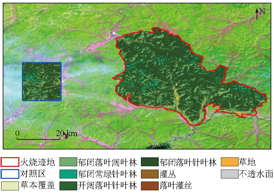
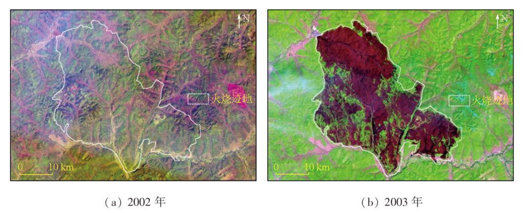
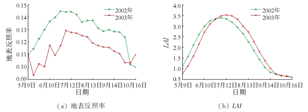
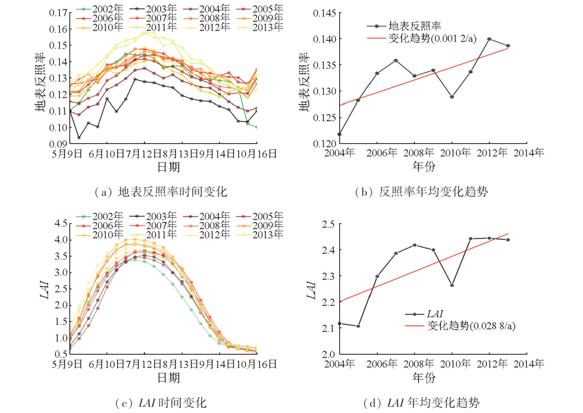
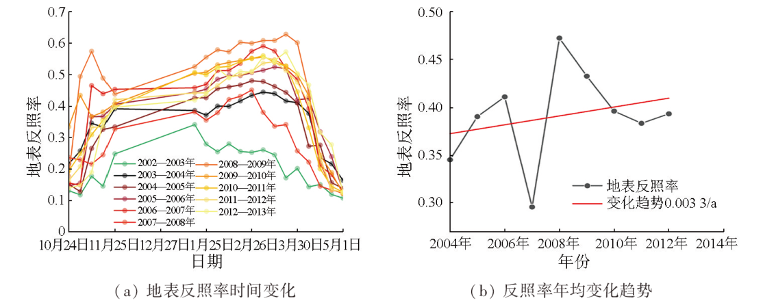
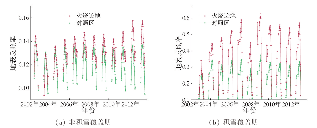
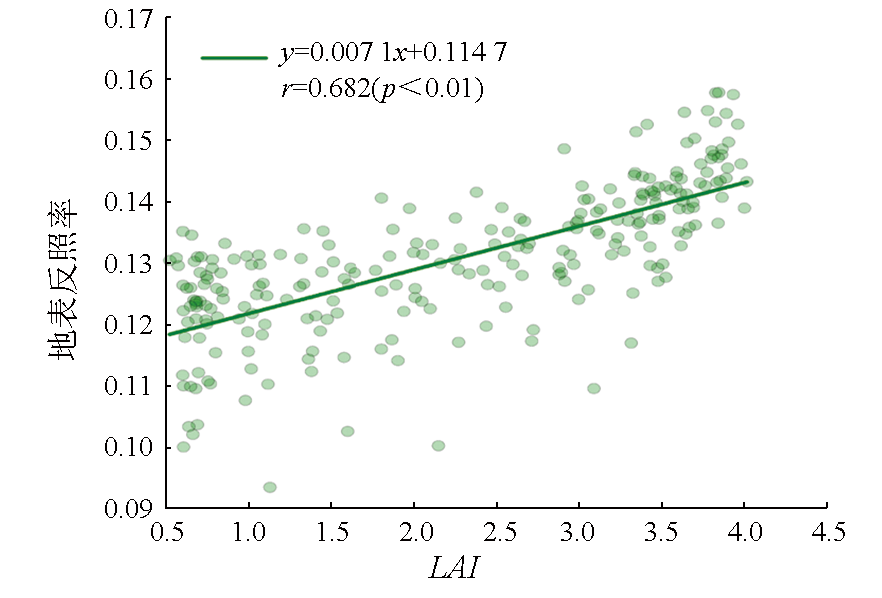
To explore the surface albedo responses to forest fires in the Great Xing’an Range, China, this study investigated the forest fire occurring in the zone under the supervision of the Jinhe Forestry Bureau on May 5, 2003. The changes in the surface albedo after the forest fire were analyzed based on the global land surface satellite (GLASS)-derived surface albedo and leaf area index (LAI) data. The results indicate that the surface albedo in the burned zone decreased in the short term (1 a) but increased significantly at a rate of 0.001 2/a in the mid- to-long term (10 a). The increasing trend in the surface albedo was slightly influenced by contemporaneous climate changes and human activities but was closely associated with the vegetation restoration process after the forest fire. Moreover, the increase in the surface albedo in the burned zone was highly correlated with LAI increase (r=0.682, p<0.01). Additionally, the vegetation masking effect further enhanced the increasing trend in surface albedo in the burned zone during the snow-covered period. Overall, the results of this study deepen the understanding of spatiotemporal variations in the surface albedo, laying a foundation for thoroughly assessing the influence of forest fires on global climate changes.
Liang S L, Wang K C, Zhang X T, et al. Review on estimation of land surface radiation and energy budgets from ground measurement,remote sensing and model simulations[J]. IEEE Journal of Selected Topics in Applied Earth Observations and Remote Sensing, 2010, 3(3):225-240.
[2]
Qu Y, Liang S L, Liu Q, et al. Mapping surface broadband albedo from satellite observations:A review of literatures on algorithms and products[J]. Remote Sensing, 2015, 7(1):990-1020.
[3]
He T, Liang S L, Yu Y Y, et al. Greenland surface albedo changes in July 1981—2012 from satellite observations[J]. Environmental Research Letters, 2013, 8(4):044043.
[4]
Flanner M G, Shell K M, Barlage M, et al. Radiative forcing and albedo feedback from the Northern Hemisphere cryosphere between 1979 and 2008[J]. Nature Geoscience, 2011, 4(3):151-155.
[5]
Jin Y, Roy D P. Fire-induced albedo change and its radiative forcing at the surface in northern Australia[J]. Geophysical Research Letters, 2005, 32(13):L13401.
[6]
Pereira P, Jordán A, Cerdà A, et al. Editorial:The role of ash in fire-affected ecosystems[J]. Catena, 2015, 135:337-339.
[7]
Quintano C, Fernandez-Manso A, Marcos E, et al. Burn severity and post-fire land surface albedo relationship in mediterranean forest ecosystems[J]. Remote Sensing, 2019, 11(19):2309.
[8]
Lyons E A, Jin Y F, Randerson J T. Changes in surface albedo after fire in boreal forest ecosystems of interior Alaska assessed using MODIS satellite observations[J]. Journal of Geophysical Research-Biogeosciences, 2008, 113(s2):G02012.
[9]
Liu H P, Randerson J T, Lindfors J, et al. Changes in the surface energy budget after fire in boreal ecosystems of interior Alaska:An annual perspective[J]. Journal of Geophysical Research-Atmospheres, 2005, 110(d13):D13101.
[10]
Amiro B D, Orchansky A L, Barr A G, et al. The effect of post-fire stand age on the boreal forest energy balance[J]. Agricultural and Forest Meteorology, 2006, 140(1-4):41-50.
[11]
Govaerts Y M, Pereira J M, Pinty B, et al. Impact of fires on surface albedo dynamics over the African continent[J]. Journal of Geophysical Research-Atmospheres, 2002, 107(d22):4629.
[12]
Gatebe C K, Ichoku C M, Poudyal R, et al. Surface albedo darkening from wildfires in northern sub-Saharan Africa[J]. Environmental Research Letters, 2014, 9(6):065003.
[13]
Roy D P, Landmann T. Characterizing the surface heterogeneity of fire effects using multi-temporal reflective wavelength data[J]. International Journal of Remote Sensing, 2005, 26(19):4197-4218.
Bao Y M, Sun Z Y, Zhao P W, et al. Spatio-temporal analysis of vegetation coverage based on remote sensing data in burned area of Genhe City[J]. Journal of Northeast Forestry University, 2015, 43(11):62-69,74.
Tian C M, Chen Z, Gao X H. Study of evapotranspiration in Qilian Mountains based on Landsat5 TM: A case of Qilian County Qinghai Province[J]. Journal of Qinghai Normal University(Natural Science), 2014, 30(2):49-56.
Lei H C, Liu Z F, Yu X J, et al. Spatial pattern inversion of soil surface total nitrogen in Datong County of Qinghai Province based on Landsat5 image[J]. Journal of Qinghai University, 2021, 39(6):79-86.
Li J, Gong A D, Chen Y L, et al. Analysis on the characteristics of change and recovery of vegetation indices for forests in burned area[J]. Journal of Geo-Information Science, 2018, 20(3):368-376.
[18]
Liang S L, Zhao X, Liu S H, et al. A long-term Global Land Surface Satellite (GLASS) data-set for environmental studies[J]. International Journal of Digital Earth, 2013, 6(s1):5-33.
[19]
Liang S L, Cheng J, Jia K, et al. The global land surface satellite (GLASS) product suite[J]. Bulletin of the American Meteorological Society, 2021, 102(2):E323-E337.
[20]
Qu Y, Liu Q, Liang S L, et al. Direct-estimation algorithm for mapping daily land-surface broadband albedo from MODIS data[J]. IEEE Transactions on Geoscience and Remote Sensing, 2014, 52(2):907-919.
[21]
Liu Q, Wang L Z, Qu Y, et al. Preliminary evaluation of the long-term GLASS albedo product[J]. International Journal of Digital Earth, 2013, 6(s1):69-95.
[22]
Ma H, Liang S L. Development of the GLASS 250-m leaf area index product (version 6) from MODIS data using the bidirectional LSTM deep learning model[J]. Remote Sensing of Environment, 2022, 273:112985.
[23]
Zhang X, Liu L Y, Chen X D, et al. GLC_FCS30:Global land-cover product with fine classification system at 30 m using time-series Landsat imagery[J]. Earth System Science Data, 2021, 13(6):2753-2776.
doi: 10.5194/essd-13-2753-2021
[24]
Theil H. A rank-invariant method of linear and polynomial regression analysis[M]//Henri Theil’s Contributions to Economics and Econometrics. Dordrecht: Springer, 1992:345-381
[25]
Mann H B. Nonparametric tests against trend[J]. Econometrica, 1945, 13(3):245.
[26]
Gersh M, Gleason K E, Surunis A. Forest fire effects on landscape snow albedo recovery and decay[J]. Remote Sensing, 2022, 14(16):4079.
[27]
Zeng Y L, Hao D L, Park T, et al. Structural complexity biases vegetation greenness measures[J/OL]. Nature Ecology and Evolution, 2023, 7(11):1790-1798.
[28]
Li X J, Zhang H Y, Qu Y. Land surface albedo variations in Sanjiang plain from 1982 to 2015:Assessing with GLASS data[J]. Chinese Geographical Science, 2020, 30(5):876-888.
[29]
Li X J, Qu Y, Wang M S, et al. Snow and land cover induced surface albedo changes in Northeast China during recent decades[J]. Theoretical and Applied Climatology, 2023, 152(1):649-661.
[30]
Alibakhshi S, Naimi B, Hovi A, et al. Quantitative analysis of the links between forest structure and land surface albedo on a global scale[J]. Remote Sensing of Environment, 2020, 246:111854.
[31]
Randerson J T, Liu H, Flanner M G, et al. The impact of boreal forest fire on climate warming[J]. Science, 2006, 314(5802):1130-1132.
pmid: 17110574
[32]
Bright R M, Zhao K G, Jackson R B, et al. Quantifying surface albedo and other direct biogeophysical climate forcings of forestry activities[J]. Global Change Biology, 2015, 21(9):3246-3266.
doi: 10.1111/gcb.12951
pmid: 25914206
 2025, Vol. 37
  ), 张恺桐, 王娇, 王沐楠, 瞿瑛(