Exploring the monitoring technology for Huanglongbing at the plot scale under satellite-ground collaboration
XIE Guoxue1(), HUANG Qiting1, YANG Shaoe1, LIANG Yongjian2, QIN Zelin1(), SU Qiuqun1
1. Agricultural Science and Technology Information Research Institute, Guangxi Academy of Agricultural Sciences, Nanning 530007, China 2. Guangxi South Subtropical Agricultural Science Research Institute, Chongzuo 532415, China
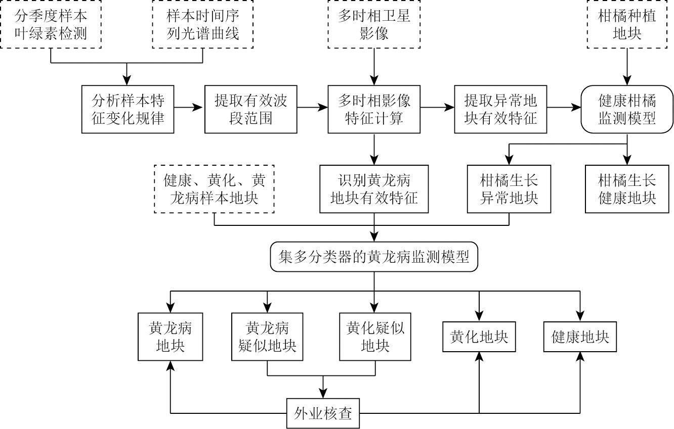
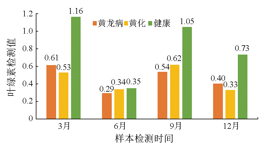
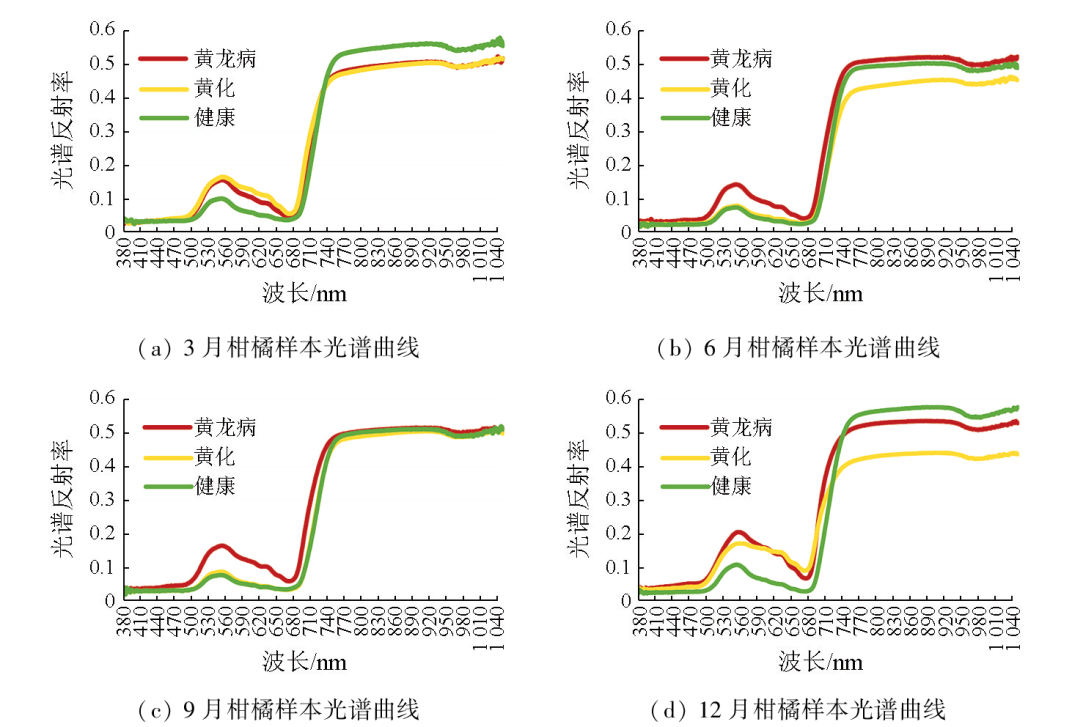
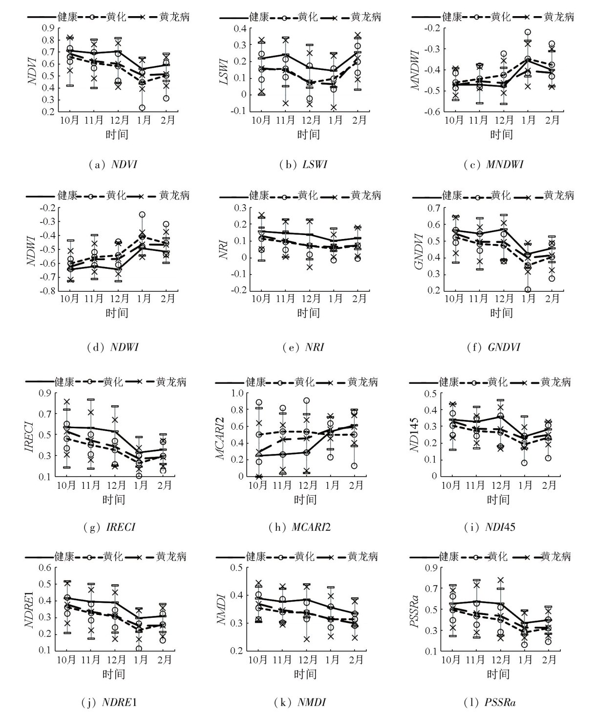
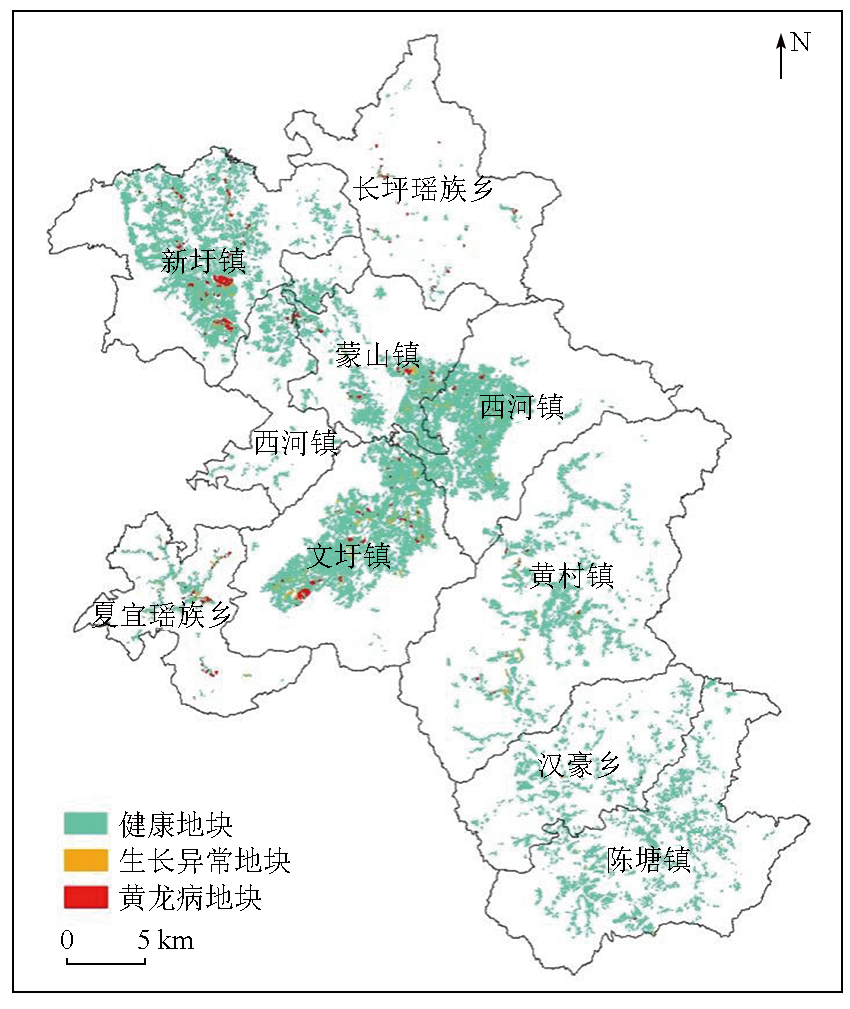
To efficiently monitor citrus greening (also called Huanglongbing in Chinese) at the large plot scale, this study investigated the healthy, yellowing, and Huanglongbing-affected citrus leaves sampled quarterly from the ground in Mengshan County in Guangxi Province. By performing polymerase chain reaction (PCR), chlorophyll content, and hyperspectral detections on these leaf samples, this study analyzed the variation patterns of citrus characteristics under different states, extracting the effective bands and image features for Huanglongbing monitoring. Furthermore, this study constructed a monitoring model for healthy citrus to reduce the objects to be discriminated and identify abnormal citrus growth plots. Finally, this study extracted the Huanglongbing-affected plots using a multi-classifier algorithm based on the effective features from multitemporal Sentinel-2 images. The results of this study indicate that the Huanglongbing-affected and yellowing leaf samples yielded highly similar chlorophyll contents. In March and December, the Huanglongbing-affected citrus exhibited higher chlorophyll content compared to the yellowing citrus. However, the case was the opposite in June and September. The hyperspectral curves suggest that December is a significant period for identifying Huanglongbing and yellowing. The wavelengths ranging from 530 nm to 650 nm and 740 nm to 1050 nm proved effective for diagnosing Huanglongbing and yellowing. The feature indices based on the Sentinel-2 image for December, including the normalized difference vegetation index (NDVI), land surface water index (LSWI), nitrogen reflectance index (NRI), green normalized difference vegetation index (GNDVI), and inverted red edge chlorophyll index (IRECI), could effectively distinguish between healthy and abnormal growth plots of citrus. The feature indices based on the Sentinel-2 images covering periods from October to December and January to February of the following year, including the NDVI, modified normalized difference water index (MNDWI), normalized difference water index (NDWI), GNDVI, inverted red-edge chlorophyll index (IRECI), modified chlorophyll absorption ratio index 2 (MCARI2), normalized difference index based on Landsat bands 4 and 5 (NDI45), and pigment specific simple ratio chlorophyll index (PSSRa), showed advantages in monitoring Huanglongbing. The identification accuracy of Huanglongbing-affected plots in Mengshan County was 86.6 %, with a missed detection rate of 7.8 % and an error rate of 10.4 %. In 2021, Mengshan County held 964 Huanglongbing-affected plots covering an area of 220.13 hm2, with an incidence rate of 2.02 % for large-scale Huanglongbing, mainly concentrated in Xinxu, Wenxu, and Mengshan towns, and Xiayi Yao Township. The combination of satellite remote sensing and ground measurement enables large-scale monitoring of Huanglongbing-affected plots. The monitoring technology in this study provides novel insights for the large-scale monitoring, prevention, and control of Huanglongbing.
Xie G X, Huang Q T, Yang S E, et al. Extraction of citrus planting plots based on medium-high different images[J]. Journal of Southern Agriculture, 2021, 52(12):3454-3462.
Lu L M, Fan G C, Hu X R, et al. PCR detection of huanglongbing pathogen in different parts of citrus plants in the field and analysis of the cause of the disease[J]. Plant Protection, 2011, 37(2):45-49.
Weng H Y, He C C, Xu J C, et al. Rapid detection of citrus Huanglongbing based on chlorophyll fluorescence imaging technology[J]. Transactions of the Chinese Society of Agricultural Engineering, 2020, 36(12):196-203.
Bai Z Q, Zhou C Y. The research progress of Citrus huanglongbing on pathogen diversity and epidemiology[J]. Chinese Agricultural Science Bulletin, 2012, 28(1):133-137.
Yu J H, Wang E G, Yang X, et al. Citrus liberobacter asiaticum morbidity and timing patterns in old orchards[J]. Journal of Agriculture, 2017, 7(4):10-14.
doi: 10.11923/j.issn.2095-4050.cjas16120026
[7]
Li X, Lee W S, Li M, et al. Spectral difference analysis and airborne imaging classification for citrus greening infected trees[J]. Computers and Electronics in Agriculture, 2012, 83:32-46.
Mei H L, Deng X L, Hong T S, et al. Early detection and grading of citrus huanglongbing using hyperspectral imaging technique[J]. Transactions of the Chinese Society of Agricultural Engineering, 2014, 30(9):140-147.
[9]
Weng H, Lyu J, Cen H, et al. Hyperspectral reflectance imaging combined with carbohydrate metabolism analysis for diagnosis of citrus Huanglongbing in different seasons and cultivars[J]. Sensors and Actuators B:Chemical, 2018, 275:50-60.
Lan Y B, Zhu Z H, Deng X L, et al. Monitoring and classification of citrus Huanglongbing based on UAV hyperspectral remote sensing[J]. Transactions of the Chinese Society of Agricultural Engineering, 2019, 35(3):92-100.
Huang Z X. Research on intelligent recognition technology of citrus Huanglongbing based on ground-air multi-source remote sensing[D]. Guangzhou: South China Agricultural University, 2020.
[12]
Xu F, Hao Z, Huang L, et al. Comparative identification of citrus huanglongbing by analyzing leaves using laser-induced breakdown spectroscopy and near-infrared spectroscopy[J]. Applied Physics B, 2020, 126(3):43.
He C C. Rapid detection citrus HLB by developing a handheld device based on spectral imaging technology[D]. Fuzhou: Fujian Agriculture and Forestry University, 2022.
Fan S D, Ma W R, Jiang W B, et al. Preliminary study on remote diagnosis technology of Citrus Huanglongbing based on deep learning[J]. China Fruits, 2022(4):76-79,86,133.
Xie G, Huang Q, Shao E Y. Hilly area citrus planting plot monitoring method and system based on remote sensing images:China,CN111709379B[P]. 2023-04-18.
Liang J T, Chen C, Zhang Z L, et al. A random forest-based method integrating indices and principal components for classifying remote sensing images[J]. Remote Sensing for Natural Resources, 2023, 35 (3):35-42.doi:10.6046/zrzyyg.2022493.
[17]
Jordan C F. Derivation of leaf-area index from quality of light on the forest floor[J]. Ecology, 1969, 50(4):663-666.
Xu H Q. A study on information extraction of water body with the modified normalized difference water index (MNDWI)[J]. Journal of Remote Sensing, 2005, 9(5):589-595.
[19]
Tucker C J. Red and photographic infrared linear combinations for monitoring vegetation[J]. Remote Sensing of Environment, 1979, 8(2):127-150.
Liu W, Yang G Q, Xu F, et al. Comparisons of detection of wheat stripe rust using hyper-spectrometer and UAV aerial photography[J]. Acta Phytopathologica Sinica, 2018, 48(2):223-227.
doi: 10.13926/j.cnki.apps.000170
[21]
Guyot G, Baret F. Utilisation de la haute resolution spectrale pour suivre L'etat des couverts vegetaux[C]// French National Institute for Agriculture,Food,and Environment (INRAE).Proceedings of the 4th International Colloquium on Spectral Signatures of Objects in Remote Sensing, 1988,279-286.
[22]
Wu C, Niu Z, Tang Q, et al. Estimating chlorophyll content from hyperspectral vegetation indices:Modeling and validation[J]. Agricultural and Forest Meteorology, 2008, 148(8/9):1230-1241.
[23]
Delegido J, Verrelst J, Alonso L, et al. Evaluation of Sentinel-2 red-edge bands for empirical estimation of green LAI and chlorophyll content[J]. Sensors, 2011, 11(7):7063-7081.
doi: 10.3390/s110707063
pmid: 22164004
[24]
Gitelson A, Merzlyak M N. Spectral reflectance changes associated with autumn senescence of Aesculus hippocastanum L.and Acer platanoides L.leaves.spectral features and relation to chlorophyll estimation[J]. Journal of Plant Physiology, 1994, 143(3):286-292.
Zhang H W, Chen H L, Zhou G H, et al. Application of normalized multiband drought index method in cropland drought monitoring[J]. Science & Technology Review, 2009, 27(11):23-26.
[26]
Blackburn G A. Quantifying chlorophylls and caroteniods at leaf and canopy scales[J]. Remote Sensing of Environment, 1998, 66(3):273-285.
 2025, Vol. 37
  ), 黄启厅1, 杨绍锷1, 梁永检2, 覃泽林1(