Construction of an ecological security pattern in the Guanzhong Plain based on ecosystem services
HUI Le1(), WANG Hao1(), LIU Jiamin1, TANG Butian1, ZHANG Weijuan2
1. School of Geography and Tourism of Shaanxi Normal University, Xi’an 710119, China 2. College of Marxism, Fujian Normal University, Fuzhou 350117, China
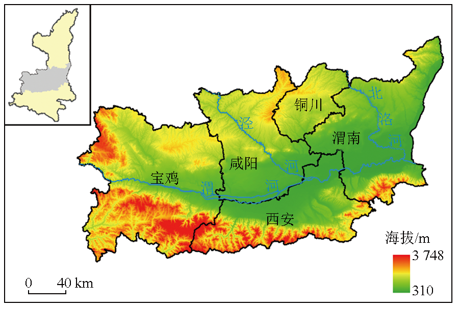
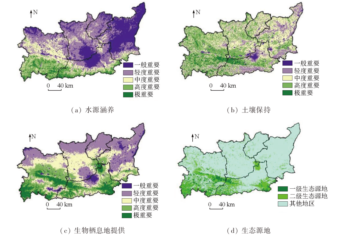
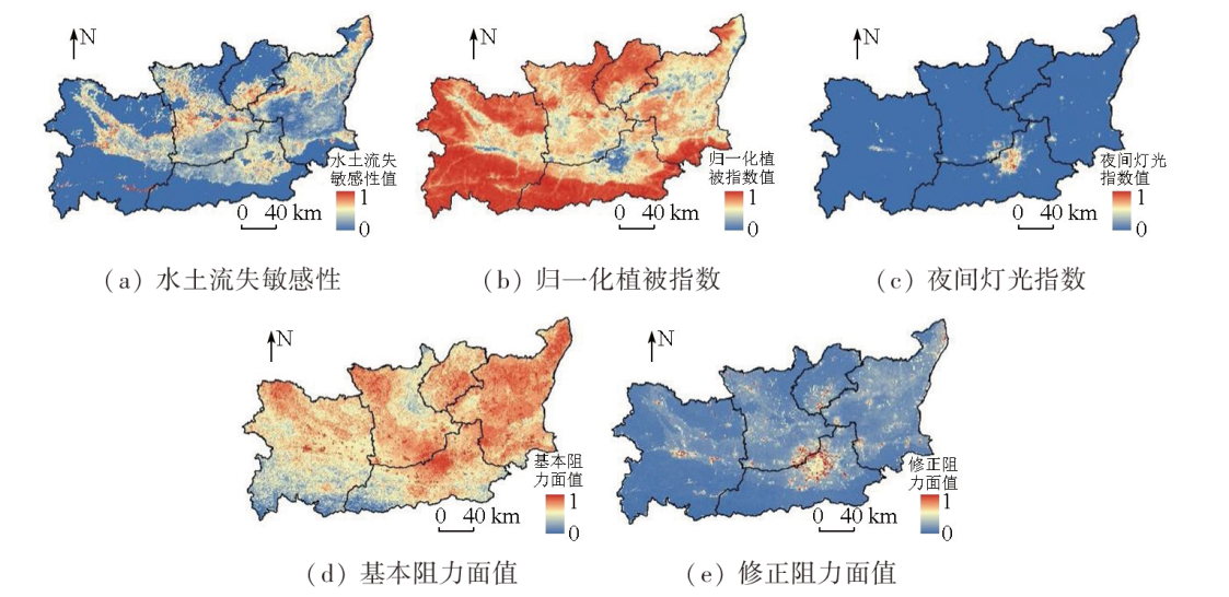
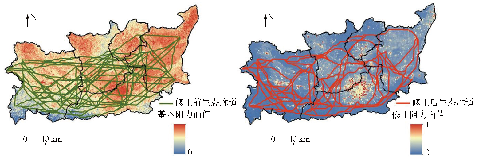
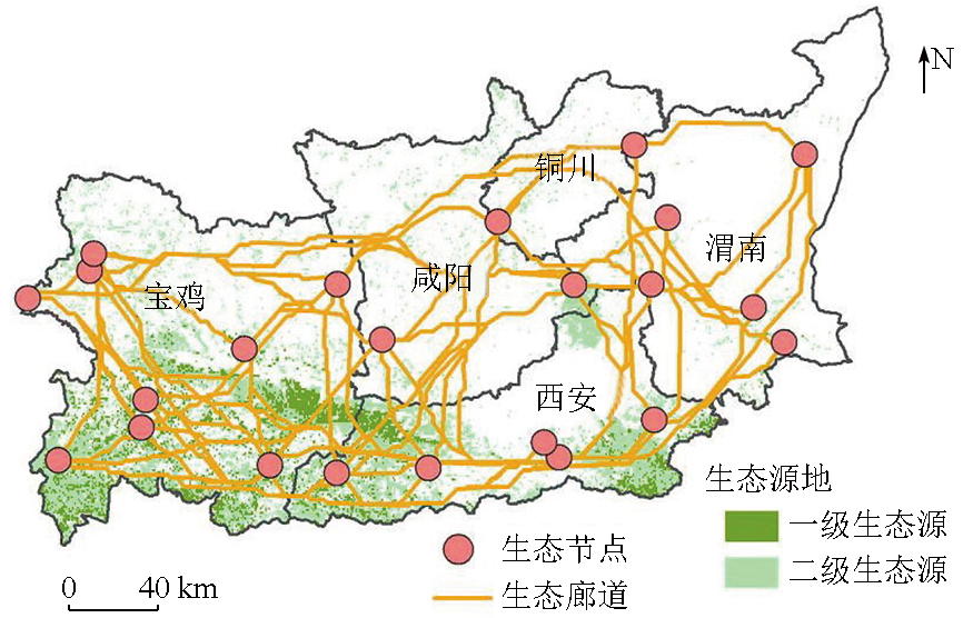
The ecological security pattern serves as an indicator of ecosystem health and sustainability, playing a crucial role in enhancing human well-being. This study identified ecological source areas in the Guanzhong Plain based on three ecosystem services, including water conservation, soil conservation, and habitat provision. Considering regional characteristics, this study selected soil erosion sensitivity index, normalized difference vegetation index (NDVI), and nighttime lighting as disturbance factors to correct the basic resistance surface and identify ecological corridors. The results indicate that the primary and secondary ecological source areas in the Guanzhong Plain cover 3 011.85 km2 and 8 434.51 km2, respectively, corresponding to 5.22% and 14.62% of the total area. These areas, characterized by mountainous terrain and high vegetation cover, are primarily distributed in the Qinling Mountains in the south, the hilly and gully regions in northern Baoji City, and the junctions of Xianyang, Tongchuan, and Weinan cities. The resistance surface correction for Guanzhong Plain reduced 61 ecological corridors (total length: 1 613.4 km), leading to significant changes in their distribution, and ultimately rationalizing corridor identification. Overall, this study provides a novel case for constructing regional ecological security patterns and data support for ecological conservation and urban planning in the Guanzhong Plain.
惠乐, 王浩, 刘嘉敏, 唐不甜, 张伟娟. 基于生态系统服务的关中平原生态安全格局构建[J]. 自然资源遥感, 2025, 37(2): 194-203.
HUI Le, WANG Hao, LIU Jiamin, TANG Butian, ZHANG Weijuan. Construction of an ecological security pattern in the Guanzhong Plain based on ecosystem services. Remote Sensing for Natural Resources, 2025, 37(2): 194-203.
Wang D C, Chen J H, Zhang L H, et al. Establishing an ecological security pattern for urban agglomeration,taking ecosystem services and human interference factors into consideration[J]. PeerJ, 2019, 7:e7306.
[2]
Qian W Q, Zhao Y, Li X Y. Construction of ecological security pattern in coastal urban areas:A case study in Qingdao,China[J]. Ecological Indicators, 2023, 154:110754.
[3]
Duan J Q, Cao Y E, Liu B, et al. Construction of an ecological security pattern in Yangtze River Delta based on circuit theory[J]. Sustainability, 2023, 15(16):12374.
Chen L D, Jing Y C, Sun R H. Urban eco-security pattern construction:Targets,principles and basic framework[J]. Acta Ecolo-gica Sinica, 2018, 38(12):4101-4108.
Ma K, Hao L N, Tong X, et al. Spatiotemporal variations of ecosystem security pattern in Horqin sandy dune meadow alternating area,China[J]. Chinese Journal of Applied Ecology, 2023, 34(8):2215-2225.
[6]
Chen J, Wang S S, Zou Y T. Construction of an ecological security pattern based on ecosystem sensitivity and the importance of ecological services:A case study of the Guanzhong Plain urban agglomeration,China[J]. Ecological Indicators, 2022, 136:108688.
Han W Y, Xia S S, Zhou W, et al. Constructing ecological security pattern based on ecological corridor identification in Lhasa River Basin[J]. Acta Ecologica Sinica, 2023, 43(21):8948-8957.
Ying L X, Kong L Q, Xiao Y, et al. The research progress and prospect of ecological security and its assessing approaches[J]. Acta Ecologica Sinica, 2022, 42(5):1679-1692.
Wang Y L, Dong W, Zhang Y L, et al. Research progress and prospect of ecological security based on ecosystem services[J]. Acta Ecologica Sinica, 2023, 43(19):7821-7829.
Ma C, Chen Y, Zhang J L, et al. Construction and optimization of ecological security pattern in Hexi Corridor[J]. Ecological Science, 2023, 42(1):206-214.
[11]
Sutton-Grier A E, Wowk K, Bamford H. Future of our coasts:The potential for natural and hybrid infrastructure to enhance the resilience of our coastal communities,economies and ecosystems[J]. Environmental Science and Policy, 2015, 51:137-148.
[12]
Seto K C, Güneralp B, Hutyra L R. Global forecasts of urban expansion to 2030 and direct impacts on biodiversity and carbon pools[J]. Proceedings of the National Academy of Sciences of the United States of America, 2012, 109(40):16083-16088.
doi: 10.1073/pnas.1211658109
pmid: 22988086
Peng J, Li H L, Liu Y X, et al. Identification and optimization of ecological security pattern in Xiong’an New Area[J]. Acta Geographica Sinica, 2018, 73(4):701-710.
Ye X, Zou C X, Liu G H, et al. Main research contents and advances in the ecological security pattern[J]. Acta Ecologica Sinica, 2018, 38(10):3382-3392.
Meng J J, Zhu L K, Yang Q, et al. Building ecological security pattern based on land use:A case study of Ordos,Northern China[J]. Acta Ecologica Sinica, 2012, 32(21):6755-6766.
Hu H D, Li X Y, Du Y F. Construction of urban ecological security pattern for Dalian[J]. Journal of Northeast Normal University (Natural Science Edition), 2013, 45(1):138-143.
Yang T R, Kuang W H, Liu W D, et al. Optimizing the layout of eco-spatial structure in Guanzhong urban agglomeration based on the ecological security pattern[J]. Geographical Research, 2017, 36(3):441-452.
Jiang Y T, Tian Y, Zheng S N. A study on urban ecosecurity pattern of island city:A case study of Pingtan Island[J]. Acta Ecologica Sinica, 2018, 38(3):769-777.
[20]
Peng J, Zhao H J, Liu Y X. Urban ecological corridors construction:A review[J]. Acta Ecologica Sinica, 2017, 37(1):23-30.
Ren Z Y, Huang Q, Li J. Quantitative analysis of dynamic change and spatial difference of the ecological safety:The case of Shaanxi Province[J]. Acta Geographica Sinica, 2005, 60(4):597-606.
Pan W T, Yue B R, Yao L J, et al. Urban ecological security pattern construction coupled with risk and service:A case study of Xianyang City,Shaanxi Province,China[J]. Chinese Journal of Applied Ecology, 2023, 34(1):178-186.
Zhang Y J, Song Y, Zhao Z H, et al. Ecological security pattern changes in Harbin based on source-sink landscape theory and MCR[J]. Geomatics and Spatial Information Technology, 2022, 45(3):1-4.
[24]
金山. 基于GIS的泉州市生态安全格局构建及空间发展预景[D]. 天津: 天津大学, 2017.
Jin S. The research of ecological security patterns and space development prospect in Quanzhou on GIS[D]. Tianjin: Tianjin University, 2017.
Sun Z X, Li W Y, Liu J M, et al. Evaluation of comprehensive be-nefit for ecological restoration in Shaanxi Province[J]. Acta Ecologica Sinica, 2022, 42(7):2718-2729.
Zhang H L, Ye C S, Hu M S. Identification and restoration strategy of key areas of ecological restoration in urban agglomeration around Poyang Lake based on ecological security pattern[J]. Research of Soil and Water Conservation, 2023, 30(2):393-402.
Peng J, Guo X N, Hu Y N, et al. Constructing ecological security patterns in mountain areas based on geological disaster sensitivity:A case study in Yuxi City,Yunnan Province,China[J]. Chinese Journal of Applied Ecology, 2017, 28(2):627-635.
[28]
Yang Y, Cai Z X. Ecological security assessment of the Guanzhong Plain urban agglomeration based on an adapted ecological footprint model[J]. Journal of Cleaner Production, 2020, 260:120973.
Yang S S, Zou C X, Shen W S, et al. Construction of ecological security patterns based on ecological red line:A case study of Jiangxi Province[J]. Chinese Journal of Ecology, 2016, 35(1):250-258.
Tan H Q, Zhang J T, Zhou X S. Construction of ecological security patterns based on minimum cumulative resistance model in Nanjing City[J]. Bulletin of Soil and Water Conservation, 2020, 40(3):282-288,296,325.
Hou S Y. Research on the construction of urban ecological security pattern in Qingyuan City,Guangdong Province based on GIS technology[J]. Intelligent City, 2022, 8(10):77-80.
[32]
Kass M J. Summary for policymakers of the global assessment report on biodiversity and ecosystem services[J]. Natural Resources and Environment, 2020, 34(3):62.
Han S H, Mei Y G, Ye C Y, et al. Construction of ecological security pattern in Yanping District of Nanping City,Fujian Province based on minimum cumulative resistance model[J]. Bulletin of Soil and Water Conservation, 2019, 39(2):192-198,205.
Peng J, Zhao H J, Liu Y X, et al. Research progress and prospect on regional ecological security pattern construction[J]. Geographical Research, 2017, 36(3):407-419.
[35]
Dai L, Liu Y B, Luo X Y. Integrating the MCR and DOI models to construct an ecological security network for the urban agglomeration around Poyang Lake,China[J]. Science of the Total Environment, 2021, 754:141868.
[36]
Dong J Q, Peng J, Xu Z H, et al. Integrating regional and interregional approaches to identify ecological security patterns[J]. Landscape Ecology, 2021, 36(7):2151-2164.
[37]
Li Z T, Li M, Xia B C. Spatio-temporal dynamics of ecological security pattern of the Pearl River Delta urban agglomeration based on LUCC simulation[J]. Ecological Indicators, 2020, 114:106319.
[38]
Li J Z, Ouyang X, Zhu X. Land space simulation of urban agglo-merations from the perspective of the symbiosis of urban development and ecological protection:A case study of Changsha-Zhuzhou-Xiangtan urban agglomeration[J]. Ecological Indicators, 2021, 126:107669.
Wu J S, Zhang L Q, Peng J, et al. The integrated recognition of the source area of the urban ecological security pattern in Shenzhen[J]. Acta Ecologica Sinica, 2013, 33(13):4125-4133.
[40]
Ma L B, Bo J, Li X Y, et al. Identifying key landscape pattern indices influencing the ecological security of inland river basin:The middle and lower reaches of Shule River Basin as an example[J]. Science of the Total Environment, 2019, 674:424-438.
Wang Z W, Wang H W, Yang S T, et al. Identification and optimization strategy of ecological security pattern of Oasis in Xinjiang based on ecosystem service function:Taking Baicheng County as an example[J]. Acta Ecologica Sinica, 2022, 42(1):91-104.
Hu J F, Chen Y X, Xu X H, et al. Ecological protection and restoration of island-type cities based on ecological security pattern identification of key areas:Taking Haitan Island in Fuzhou as an example[J]. Journal of Shandong Forestry Science and Technology, 2022, 52(6):1-11.
Mao C R, Dai L M, Qi L, et al. Constructing ecological security pattern based on ecosystem services:A case study in Liaohe River Basin,Liaoning Province,China[J]. Acta Ecologica Sinica, 2020, 40(18):6486-6494.
Zhao Y H, Luo Y H, Yi T Y, et al. Constructing an ecological security pattern in Shenzhen,China,by matching the supply and demand of ecosystem services[J]. Chinese Journal of Applied Ecology, 2022, 33(9):2475-2484.
Han R Y, Zhao Z P, Xiao N W, et al. Construction of ecological security pattern in Beijing City based on minimum resistance model[J]. Bulletin of Soil and Water Conservation, 2022, 42(3):95-102.
Li X P, Li J S, Hou W. Research on refined simulation of regional ecological network and corridor optimization:A case study of Fenhe River Basin[J]. Geography and Geo-Information Science, 2020, 36(5):14-20,55.
Xiong S G, Qin C B, Yu L, et al. Methods to identify the boundary of ecological space based on ecosystem service functions and ecological sensitivity:A case study of Nanning City[J]. Acta Ecologica Sinica, 2018, 38(22):7899-7911.
Xu C F, Cao Y E, Xu Z L, et al. A study on identification methods of ecological source area in Aksu Area,Xinjiang Ulgur Autonomous Region[J]. Bulletin of Soil and Water Conservation, 2021, 41(4):174-181,188.
Chen Y Y, Luo Z J, Qi S, et al. Ecological security pattern construction of Nanchang City based on ecological sensitivity and ecological network[J]. Research of Soil and Water Conservation, 2021, 28(4):342-349.
 2025, Vol. 37
  ), 王浩1(