Analysis on water conservation function using remote sensing method in the Three Gorges Reservoir area (Chongqing section)
YE Qinyu1,2(), YANG Shiqi1,2(), ZHANG Qiang3, WANG Shu4, HE Zeneng1,2, ZHENG Yinghui3
1. Chongqing Institute of Meteorological Sciences, Chongqing 401147, China 2. Chongqing Engineering Research Center of Agrometeorology and Satellite Remote Sensing, Chongqing 401147, China 3. Chongqing Meteorological Bureau, Chongqing 401147, China 4. National Meteorological Information Center, Beijing 100081, China
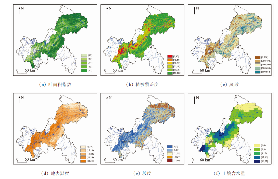
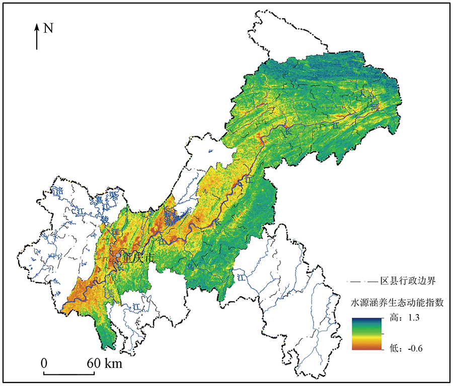
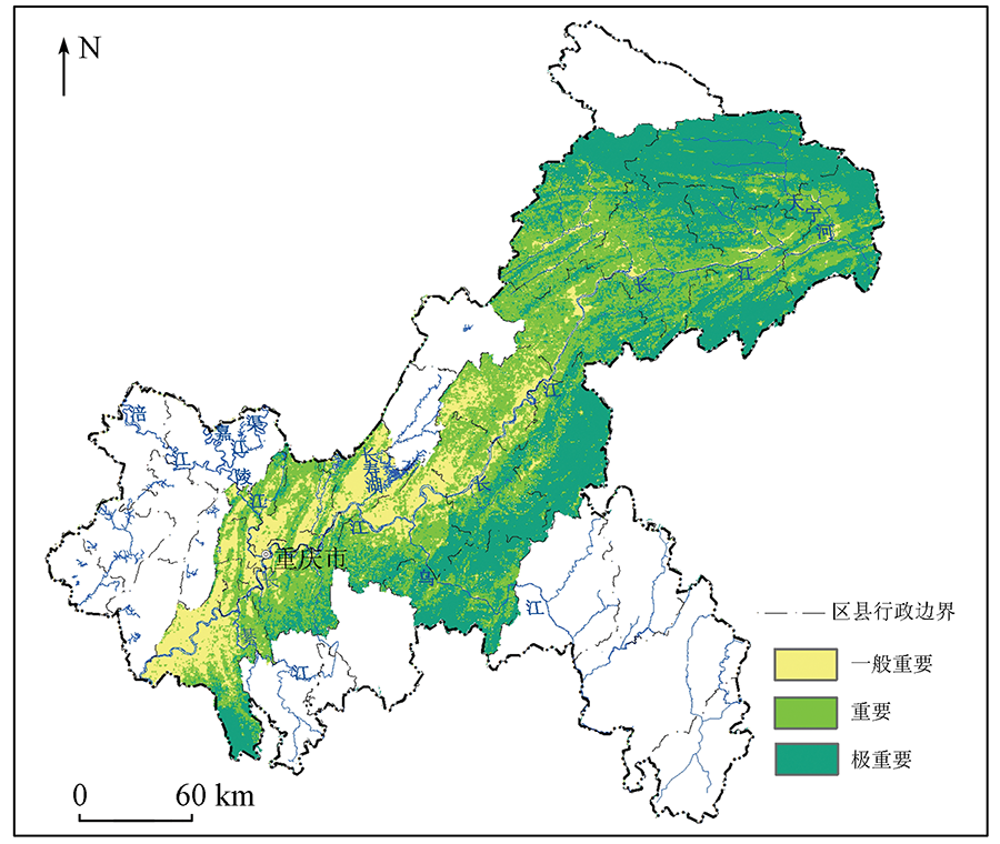
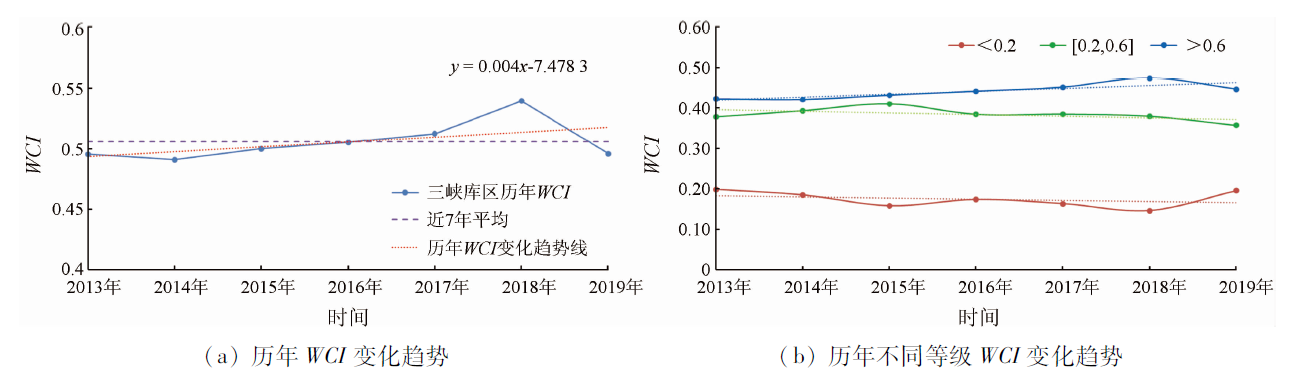
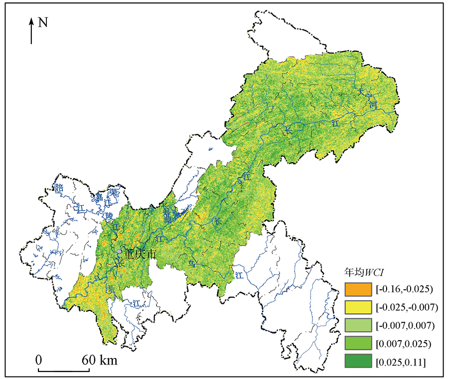
Water conservation is one of the most important functions of an ecosystem and can maintain and provide water resources for the ecosystem and humans. According to the physical meaning of water conservation, this study used leaf area index, vegetation coverage, and evapotranspiration to represent the water conservation of the vegetation layer and used surface temperature, soil moisture content, and slope to represent the water conservation capacity of the soil layer. Then, this study developed a remote sensing monitoring and evaluation model for water conservation through principal component analysis to explore the spatial-temporal distribution characteristics of the water conservation capacity in the Three Gorges reservoir area. The results show that the water conservation index (WCI) contained the objective information of various indices, could be used to quickly and conveniently assess the water conservation function in the Three Gorges Reservoir area, and properly represented the water conservation capacity there. In 2019, the water conservation capacity was unevenly distributed in the Three Gorges reservoir area and was high downstream and low upstream. The northeastern part of Chongqing was dominated by forest ecosystems and had the strongest water conservation function. From 2013 to 2019, the WCI slightly increased in most areas, especially in some parts of Fengdu, Kaizhou, and Yunyang areas.
叶勤玉, 杨世琦, 张强, 王舒, 何泽能, 郑颖慧. 三峡库区(重庆段)水源涵养功能遥感监测及时空分布特征分析[J]. 自然资源遥感, 2022, 34(2): 184-193.
YE Qinyu, YANG Shiqi, ZHANG Qiang, WANG Shu, HE Zeneng, ZHENG Yinghui. Analysis on water conservation function using remote sensing method in the Three Gorges Reservoir area (Chongqing section). Remote Sensing for Natural Resources, 2022, 34(2): 184-193.
Ball P. Water,water everywhere?[J]. Nature, 2004, 427(6969):19-20.
doi: 10.1038/427019a
[2]
环境保护部. 生态保护红线划定指南[M]. 北京: 环境保护部, 2015.
Ministry of Ecology and Environment of the People’s Republic of China. Ecological protection red line delineated Guide[M]. Beijing: Ministry of Ecology and Environment of the People’s Republic of China, 2015.
Gong S H, Xiao Y, Zheng H, et al. Spatial patterns of ecosystem water conservation in China and its impact factors analysis[J]. Acta Ecologica Sinica, 2017, 37(7):2455-2462.
Shi P L, Wu B, Cheng G W, et al. Water retention capacity evaluation of main forest vegetation types in the upper Yangtze basin[J]. Journal of Natural Resources, 2004, 19(3):351-360.
Wang S T, Sun X B, Xia W, et al. Evaluating on significance function of water conservation in forest ecosystem-Taking Dabieshan Mountain in western Anhui Province as an example[J]. Resource Development & Market, 2019, 35(10):1252-1257.
[6]
Xu J, Xiao Y, Xie G D. Analysis on the spatio-temporal patterns of water conservation services in Beijing[J]. Journal of Resources and Ecology, 2019, 10(4):362-372.
doi: 10.5814/j.issn.1674-764x.2019.04.003
Cheng Y F. Study on the change of water conservation capacity and grassland ecological compensation in Sanjianyuan National Park based on InVEST model[D]. Yunnan: Yunnan University of Finance and Economics, 2019.
Lv L T, Ren T T, Sun C Z, et al. Spatial and temporal changes of water supply and water conservation function in Sanjiangyuan National Park from 1980 to 2016[J]. Acta Ecologica Sinica, 2020, 40(3):993-1003.
Liu J, Fu B, Zhang C H, et al. Assessment of ecosystem water retention and its value in the upper reaches of Minjiang River based on InVEST model[J]. Resources and Environment in the Yangtze Basin, 2019, 28(3):577-585.
Li L, Su W C, Ge Y J. Analysis on water conservation capacity of forest ecosystem in Chongqing[J]. Research of Soil and Water Conservation, 2015, 22(2):96-100.
Pan M, Chen T W, Huang L, et al. Spatial and temporal variations in ecosystem services and its driving factors analysis in Jing-Jin-Ji region[J]. Acta Ecologica Sinica, 2020(15):1-17.
Xu H Q. Assessment of ecological change in soil loss area using remote sensing technology[J]. Transactions of the Chinese Society of Agricultural Engineering, 2013, 29(7):91-97,294.
Shi T T, Xu H Q, Sun F Q, et al. Remote-sensing-based assessment of regional ecological changes triggered by a construction project:A case study of Aojiang River Watershed[J]. Acta Ecologica Sinica, 2019(18):1-14.
Yang H T, Xu H Q. Assessing fractional vegetation cover changes and ecological quality of the Wuyi Mountain National Nature Reserve based on remote sensing spatial information[J]. Chinese Journal of Applied Ecology, 2020, 31(2):533-542.
Li Y C, Liu C X, Min J, et al. RS/GIS based integrated evaluation of the ecosystem services of the Three Gorges Reservoir area (Chongqing section)[J]. Acta Ecologica Sinica, 2013, 33(1):168-178.
doi: 10.5846/stxb201107020989
Zhang D J, Yang S Q, Wang Y Q, et al. Refined water body information extraction of Three Gorges reservoir by using GF - 1 satellite data[J]. Yangtze River, 2019, 50(9):233-239.
Deng K M, Shi P L, Xie G D. Water conservation of forest ecosystem in the upper reaches of yangtze river and its benefits[J]. Resources Science, 2002, 24(6),68-73.
Zhou J W, Gao J X, Gao Z Q, et al. Analyzing the water conservation service function of the forest ecosystem[J]. Acta Ecologica Sinica, 2018, 38(5):1679-1686.
Chen S S, Liu K, Bao Y B, et al. Spatial pattern and influencing factors of water conservation service function in Shangluo City[J]. Scientia Geographica Sinica, 2016, 36(10):1546-1554.
Li M M, Wu B F, Yan C Z, et al. Estimation of vegetation fraction in the upper basin of Miyun Reservoir by remote sensing[J]. Resources Science, 2004, 26:153-159.
Yin Y H, Wu S H, Zhao D S, et al. Ecosystem water conservation changes in response to climate change in the Source Region of the Yellow River from 1981 to 2010[J]. Geographical Research, 2016, 35(1):49-57.
Li S Q, Su D B L G, Ha S, et al. Water conservation function of forest ecosystem and its spatial distribution characteristics in upper reaches of the yangtze river[J]. Bulletin of Soil and Water Conservation, 2011, 31(4):62-67.
[25]
Hu W M, Li G, Gao Z H, et al. Assessment of the impact of the Poplar Ecological Retreat Project on water conservation in the Dongting Lake wetland region using the InVEST model[J]. Science of the Total Environment, 2020, 733:1-13.
Zheng P L, Xiao J W, Wu Y, et al. Research on forest soil water retaining properties of typical forests in Jinyun Mountain in Chongqing City[J]. Research of Soil and Water Conservation, 2006(2):195-197.
[27]
徐建华. 计量地理学[M]. 北京: 高等教育出版社, 2006.
Xu J H. Econometric geography[M]. Beijing: Higher Education Press, 2006.
Zeng L, Li J, Li T, et al. Optimizing spatial patterns of water conservation ecosystem service based on Bayesian belief networks[J]. Journal of Geographical Sciences, 2018, 73(9):1809-1822.
Qi J, Yuan X Z, Liu H, et al. Spatio temporal characteristics of ecosystem service in key water resource conservation function area of Three Gorges Area in Chongqing City[J]. Bulletin of Soil and Water Conservation, 2015, 35(3):256-260,266,365.
Gu Z M, Jin X B, Shen C Z, et al. Variation and influence factors of water conservation service function in Jiangsu Province from 2000 to 2015[J]. Resources and Environment in the Yangtze Basin, 2018, 27(11):2453-2462.
Cui J X, Li X F, Zheng H F, et al. Spatial analysis of water conservation function in northeast China under different climatic conditions[J]. Acta Ecologica Sinica, 2019, 39(9):3026-3038.
[33]
环境保护部. 全国生态功能区划(修编版)[M]. 北京: 环境保护部, 2015.
Ministry of Ecology and Environment of the People’s republic of china. National ecological function zoning (revised version)[M]. Beijing: Ministry of Ecology and Environment of the People’s Republic of China, 2015.
 2022, Vol. 34
  ), 杨世琦1,2(