Spatiotemporal variations of geological disaster risk and obstacle factor diagnosis: A case study of the western Sichuan region
YANG Hengjun1(), YANG Xin1,2(), ZHOU Xiong3
1. College of Geography and Planning, Chengdu University of Technology, Chengdu 610059, China 2. Key Laboratory of Earth Exploration and Information Techniques, Ministry of Education, Chengdu 610059, China 3. Institute of Multipurpose Utilization of Mineral Resources, Chinese Academy of Geological Science, Chengdu 610041, China
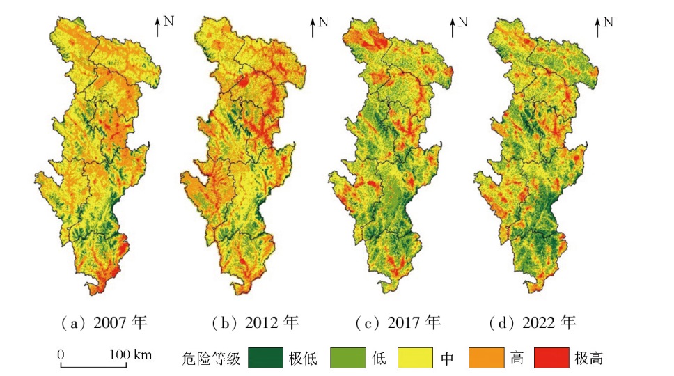
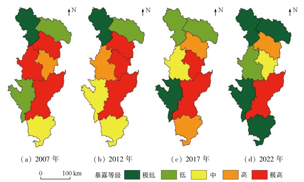
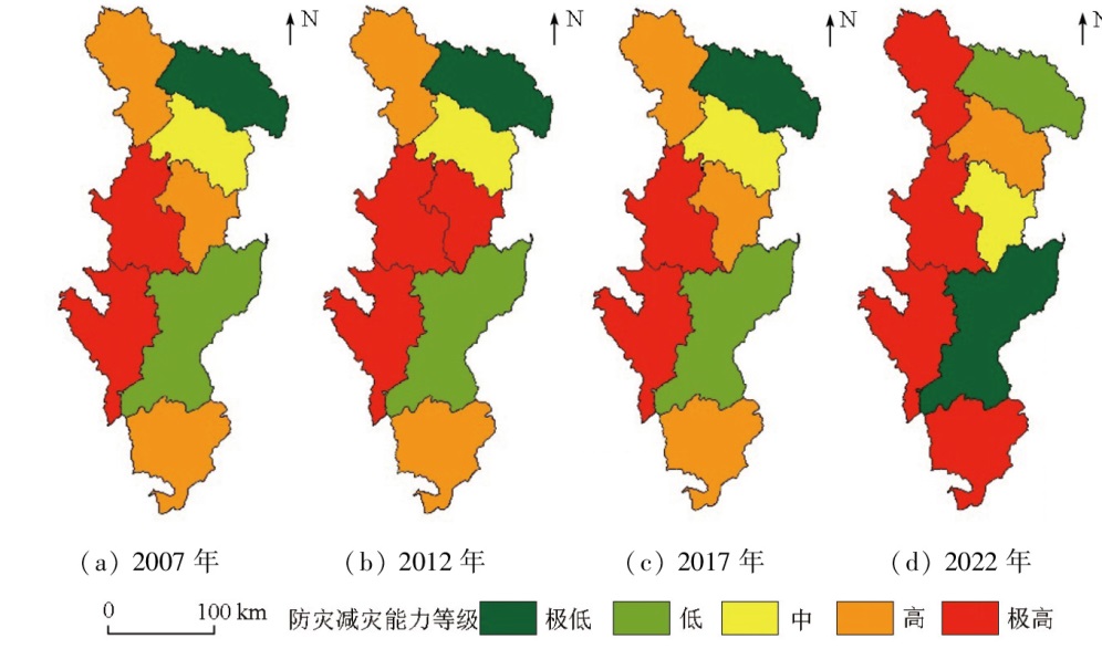
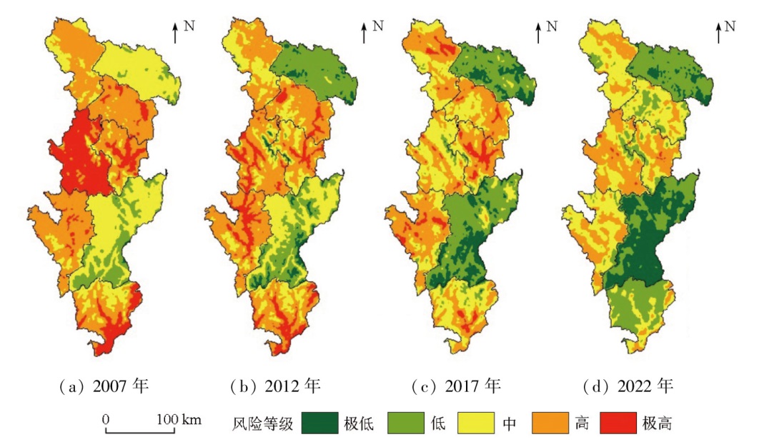
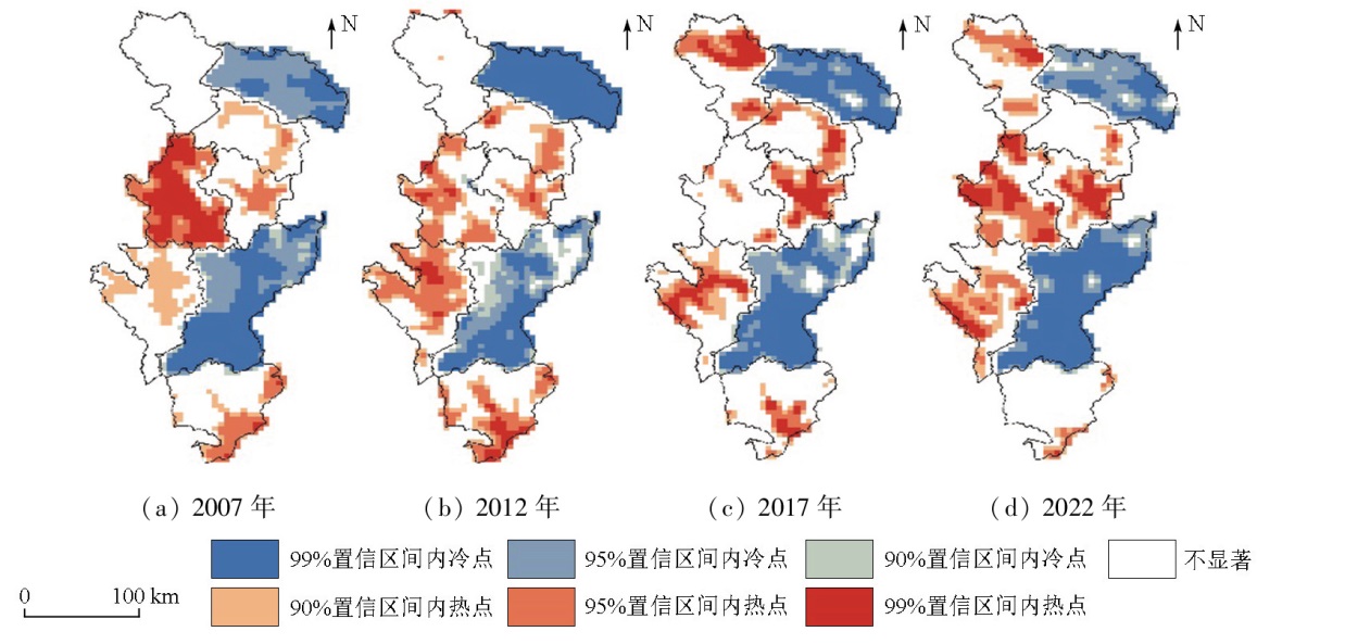
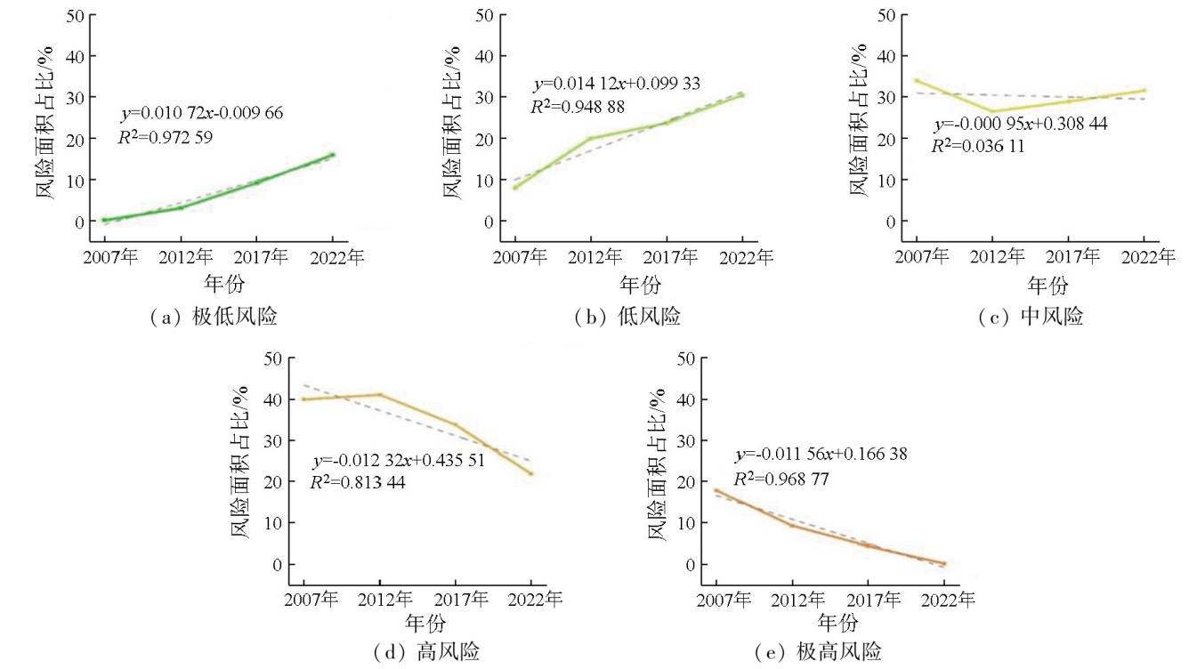
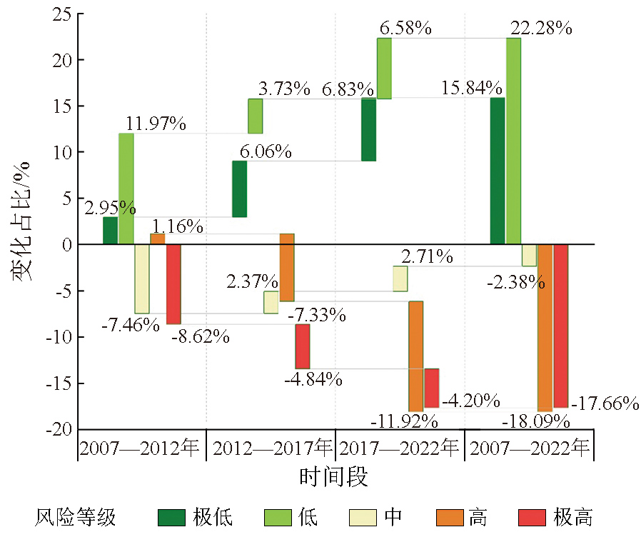
Geological disasters, influenced by natural and human factors, directly threaten the safety of people’s lives and property. Exploring the spatiotemporal variations and development mechanisms of geological disaster risk can enhance disaster prevention and mitigation. This study examined 31 factors such as topography, rainfall, and social economy from the perspectives of nature and humanity. Based on the four-factor risk theory, this study investigated the variations of geological disaster risk in the western Sichuan region using methods like the analytic hierarchy process, principal component analysis, information value model, entropy weight method, and hot/cold spot analysis. Employing the obstacle degree model, this study explored the degrees of influence of various factors on geological disaster risk in the western Sichuan region. The results indicate that from 2007 to 2022, the geological disaster risk in the western Sichuan region was generally characterized by higher levels in the west and lower levels in the east. Kangding and Maerkang were the concentrated distribution areas of perennial cold spots. The area of extremely low and low risk levels increased by 8 871.1 km2 and 12 478.6 km2 respectively at growth rates of 1.056%/a and 1.485%/a respectively. The area of high and extremely high risk levels decreased by 10 127.8 km2 and 9 880.1 km2 respectively at growth rates of -0.02484 km2/a. The degrees of influence of various factors on risk levels exhibited temporal heterogeneity. The dominant obstacle factors (obstacle degree: above 5 %) were concentrated in risk and disaster prevention and mitigation indicators. Factors including rainfall, topography, and medical resources contributed significantly to geological disaster risk.
杨衡钧, 杨鑫, 周雄. 川西地质灾害风险时空变化及障碍因子诊断[J]. 自然资源遥感, 2025, 37(4): 140-151.
YANG Hengjun, YANG Xin, ZHOU Xiong. Spatiotemporal variations of geological disaster risk and obstacle factor diagnosis: A case study of the western Sichuan region. Remote Sensing for Natural Resources, 2025, 37(4): 140-151.
Ministry of Natural Resources of the People’s Republic of China. Statistical bulletin of China’s natural resources in 2022[R/OL]. 2023(2023-04-12). https://gi.mnr.gov.cn/202304/t20230412_2781113.html.
Zhen Y, Lu X Y, Pu H L, et al. Geological hazard risk assessment in Hongkou County of Dujiangyan[J]. Science of Surveying and Mapping, 2016, 41(11):66-71,97.
Yang S Y, Weng M Z, Tian H, et al. Landslide risk evaluation in the urban area in Hefeng County,Hubei Province[J]. Safety and Environmental Engineering, 2021, 28(1):144-155.
Tang Y M, Zhang M S, Li L, et al. Discrimination to the landslide susceptibility,hazard and risk assessment[J]. Hydrogeology and Engineering Geology, 2011, 38(2):125-129.
Xu Q F, He K S, Hu L Y, et al. Quantitative risk assessment of geological hazards based on hazard source identification:A case study of Maotai Town,Guizhou Province[J]. Safety and Environmental Engineering, 2023, 30(5):152-165.
Zhou C, Chang M, Xu L, et al. Risk assessment of typical urban mine geological disasters in Guizhou Province[J]. Geomatics and Information Science of Wuhan University, 2020, 45(11):1782-1791.
Liu J P, Liang E J, Xu S H, et al. Multi-kernel support vector machine considering sample optimization selection for analysis and evaluation of landslide disaster susceptibility[J]. Acta Geodaetica et Cartographica Sinica, 2022, 51(10):2034-2045.
doi: 10.11947/j.AGCS.2022.20220326
[9]
Wang W D, Li J Y, Han Z. Comprehensive assessment of geological hazard safety along railway engineering using a novel method:A case study of the Sichuan-Tibet Railway,China[J]. Geomatics,Natural Hazards and Risk, 2020, 11(1):1-21.
Ai L, Yang B Y, Guo L. Comparison of landslide susceptibility evaluation based on different data units and models[J]. Geospatial Information, 2020, 18(6):117-121.
Zhou B, Sui J, Sun H, et al. Evaluation of geological disasters in Qinghai Province based on multi-source remote sensing data[J]. Journal of Natural Disasters, 2022, 31(4):231-240.
Shu H P, Ma J Z, Zhang P, et al. Risk assessment of debris flow hazards in different rainfall frequencies[J]. Journal of Lanzhou University (Natural Sciences), 2014, 50(5):653-658.
Song Y X, Zou Y J, Ye R Q, et al. Dynamic analysis of landslide hazards in the Three Gorges Reservoir area based on Google Earth Engine[J]. Remote Sensing for Natural Resources, 2024(1):154-161.doi:10.6046/zrzyyg.2022464.
Yan G, Liang S Y, Zhao H L. An approach to improving slope unit division using GIS technique[J]. Scientia Geographica Sinica, 2017, 37(11):1764-1770.
doi: 10.13249/j.cnki.sgs.2017.11.019
[15]
Woodard J B, Mirus B B, Wood N J, et al. Slope unit maker (SUMak):An efficient and parameter-free algorithm for delineating slope units to improve landslide modeling[J]. Natural Hazards and Earth System Sciences, 2024, 24(1):1-12.
Zhao P, Zhao S Y, Sun Y, et al. Landslide susceptibility assessment in southern Anhui Province based on slope units and semantic segmentation[J]. Chinese Journal of Geology, 2024, 59(2):562-574.
Tang C, Ma G C. Small regional geohazards susceptibility mapping based on geomorphic unit[J]. Scientia Geographica Sinica, 2015, 35(1):91-98.
doi: 10.13249/j.cnki.sgs.2015.01.91
Zhang Q, Yi J S, Zhang Y, et al. Geohazard risk assessment about county units in southwest mountainous areas of China:Take Lushui County of Nujiang River basin as an example[J]. Journal of Natural Disasters, 2022, 31(5):212-221.
Wen X, Fan X M, Chen L, et al. Susceptibility assessment of geological disasters based on an information value model:A case of Gulin County in Southeast Sichuan[J]. Bulletin of Geological Science and Technology, 2022, 41(2):290-299.
Lu X N, Hong J, Wang L L, et al. Drought risk assessment in complex landform area[J]. Transactions of the Chinese Society of Agricultural Engineering, 2015, 31(1):162-169.
Chen J W, Zhang J Q, A L S, et al. Risk assessment of debris flow in the mountain areas based on the PSO-AHP:A case study in Jiaohe City of Jilin Province[J]. Journal of Northeast Normal University (Natural Science Edition), 2019, 51(3):152-160.
Zhou B, Zou Q, Jiang H, et al. Research on climate change characteristics and change of debris flow hazard in the Chuanxi Plateau[J]. Journal of Natural Disasters, 2022, 31(4):241-255.
Li H Y, Zhang Y R, Fu G, et al. Pollution characteristics and control strategies of volatile organic compounds in coking pollution area in spring[J]. China Environmental Science, 2024, 44(3):1234-1243.
Wen Y N, Zhang Z H, Mu H W, et al. Landslide disaster spatial prediction under dynamic multi-source data-driven model[J]. Journal of Natural Disasters, 2021, 30(3):83-92.
He H X, Li B. Datong flash flood characteristics and disaster risk analysis in Qinghai Province on August 18[J]. Remote Sensing for Natural Resources: 2024, 36(2):135-141.doi:10.6046/zrzyyg.2023002.
 2025, Vol. 37
  ), 杨鑫1,2(