1. Faculty of Geomatics, East China University of Technology, Nanchang 330013, China 2. Key Laboratory of Watershed Ecology and Geographical Environment Monitoring, National Administration of Surveying,Mapping and Geoinformation, Nanchang 330013, China 3. South Digital Technology Co., Ltd., Guangzhou 510665, China
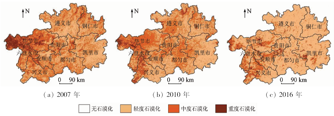
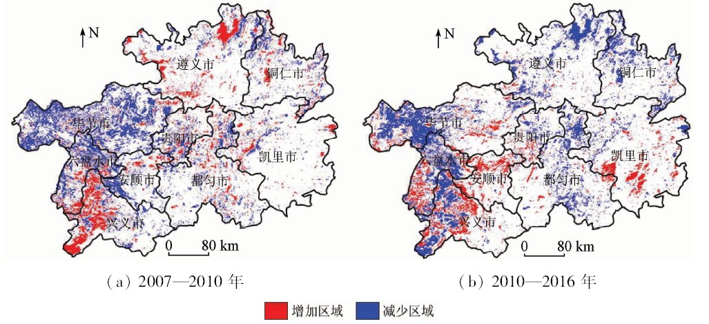
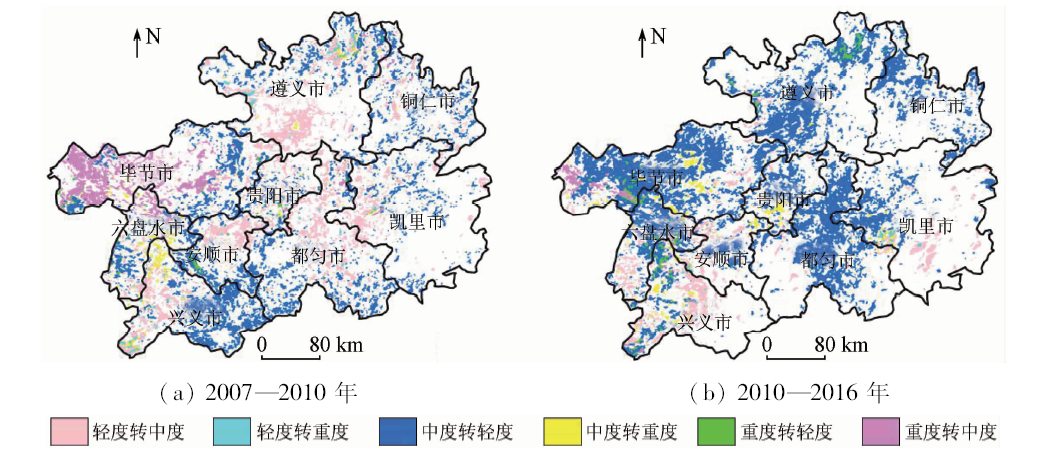
Monitoring the spatial pattern and dynamic change of Karst rocky desertification has an important significance in Karst areas. In this study, the Karst rocky desertification evaluation model was established in Guizhou Province, which based on vegetation fractional coverage and degree of exposed bedrock using multi-temporal MODIS data, slope and population density as evaluation factors. The contribution of four factors was compared to accomplish the judgment matrix and calculate the weight by analytic hierarchy process. Karst rocky desertification evaluation model was established through consistency check. By this evaluation model, the spatial patterns of Karst rocky desertification and characteristics of conversion in different degree of desertification were acquired, the spatial-temporal evolution and dynamic change of Karst rocky desertification were analyzed in the period of 2007—2016. Some conclusions have been reached: ①Karst rocky desertification was improved dramatically from 2007 to 2016. The proportion of moderate rocky desertification and severe rocky desertification was 55.67% and 40.53% respectively in 2010 but was 79.71% and 17.35% in 2016. ②Moderate rocky desertification was the intermediary process of severe rocky desertification transform to light rocky desertification. It can firstly transform severe rocky desertification to moderate rocky desertification and then transform to light rocky desertification. ③Moderate rocky desertification and light rocky desertification were active, whereas severe rocky desertification was stable and the conversion rate was low.
Gao G L, Deng Z M, Xiong K N , et al. The Call and Hope of Karst:Construction and Sustainable Development of Karst Ecological Environment in Guizhou Province[M]. Guiyang: Guizhou Science and Technology Publishing House Co.,Ltd., 2003.
Yuan C, Zhou C P, Tong L Q , et al. The causes and tackle countermeasures of land rocky desertification in Guizhou Province[J]. Geo-science, 2003,17(2):181-185.
Li S M, Shu N, Tao J B , et al. Rock desertification data feature selection method based on K2 structure learning algorithm[J]. Journal of Guilin University of Technology, 2009,29(4):548-554.
Lan A J, Xiong K N, An Y L . Analysis on driving factors of Karst rock-desertification with a special reference to Guizhou Province[J]. Bulletin of Soil and Water Conservation, 2001,21(6):19-23.
Li S, An Y L, Hua H Q . Automated method based on change detection for extracting Karst rock desertification information using remote sensing[J]. Remote Sensing Technology and Application, 2012,27(1):149-153.
Wang K . Research on the Threshold of the Key Factors for the Evolution of Rocky Desertification in Typical Karst Area and Early Warning Analysis[D]. Guiyang:Guizhou Normal University, 2016.
Liu J W, Wang H S . Ecological environmental construction and rural economic development in Karst mountainous areas of Guizhou Province[J]. Guizhou Agriculture Sciences, 2010,38(6):227-231.
Bai X Y, Wang S J, Chen Q W , et al. Spatio-temporal evolution process and its evaluation method of Karst rocky desertification in Guizhou Province[J]. Acta Geographica Sinca, 2009,64(5):609-618.
Li Y B, Wang S J, Li R L , et al. Discussion on the construction to Karst mountain ecology in southwest China:A case in Guizhou Province[J]. Carsologica Sinca, 2004,23(1):20-24.
Hu F . Study on the Landscape Features and Ecological Environment Effect of Semi-Karst Region:A Case Study of Guizhou Province[D]. Guiyang:Guizhou Normal University, 2016.
Li R L, Wang S J, Xiong K N , et al. A study on rocky desertification index system:A case of Guizhou Province[J]. Tropical Geography, 2004,24(2):145-149.
Huang Y, Xie S Y, Zhao Y P . Karst desertification investigation based on ETM image:A case study of Nanchuan City[J]. Remote Sensing for Land and Resourses, 2008,20(1):55-58.doi: 10.6046/gtzyyg.2008.01.12.
Yue Y M, Wang K L, Zhang B , et al. Uncertainty of remotely sensing extraction of information of Karst rocky desertification[J]. Advances in Earth Science, 2011,26(3):266-274.
Yue Y M, Zhang B, Wang K L , et al. Remote sensing of indicators for evaluating Karst rocky desertification[J]. Journal of Remote Sensing, 2011,15(4):722-736.
[20]
Rikimaru A. Landsat TM data processing guide for forest canopy density mapping and monitoring model [C]//ITTO workshop on utilization of remote sensing in site assessment and planning for rehabilitation of logged-over forest,Bangkok,Thailand, 1996,8:1-8.
[21]
Saaty T L . The Analytic Hierarchy Process:Planning,Priority Setting,Resource Allocation[M]. New York:Mc Graw-Hill, 1980.
Liu F, He B Y, Zhang L , et al. Evaluation of Karst rocky desertification based on thermal infrared remote sensing in Pingguo Country,Guangxi[J]. Resources and Environment in the Yangtze Basin, 2016,25(6):952-956.
Li L, Tong L Q, Li X H . The remote sensing information extraction method based on vegetation coverage[J]. Remote Sensing for Land and Resources, 2010,22(2):59-62.doi: 10.6046/gtzyyg.2010.02.13.
Ju J H, Song H R, Zhou P . Karst rocky desertification current survey in Southwest China[ C]//National Land Resource and Environmental Remote Sensing Technology Conference, 2004.
Zhao L P . Study on Developmental Characteristics of the Karst Rocky Desertification Based on MODIS[D].Beijing:China University of Geosciences( Beijing), 2015.
Li X, Xu H Q, Li J , et al. Extraction of bare soil features from SPOT-5 imagery based on NDSI and NDISI[J].Journal of Geo-Information Science,2016(1):117-123.
 2019, Vol. 31
  ), 李嘉伟3, 袁晨鑫1, 李睿1