Application and exploration of dissolved oxygen inversion of plateau salt lakes based on spectral characteristics
DU Cheng1,2,3(), LI Delin1,2,3(), LI Genjun1,2,3, YANG Xuesong1,2,3
1. Key Laboratory of Geological Processes and Mineral Resources of the Northern Qinghai-Tibet Plateau,Xining 810012, China 2. Qinghai Remote Sensing Big Data Engineering Technology Research Center, Xining 810012, China 3. Qinghai Geological Survey, Xining 810012, China
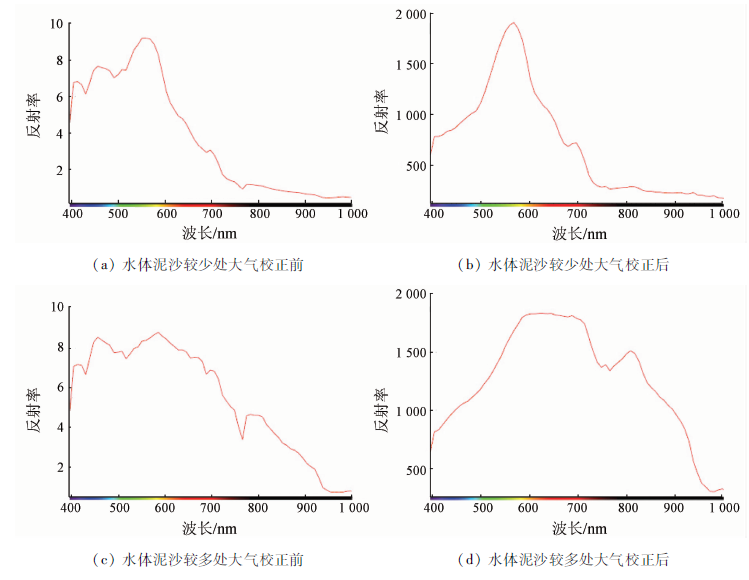
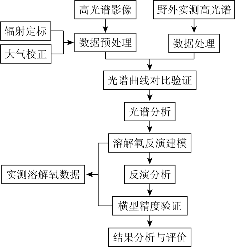
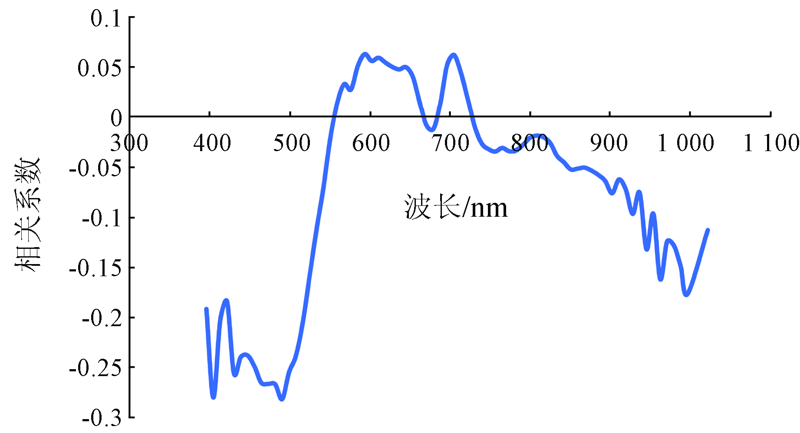
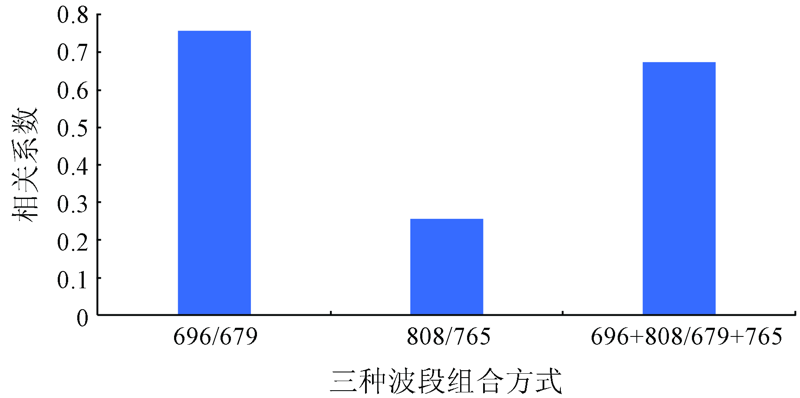
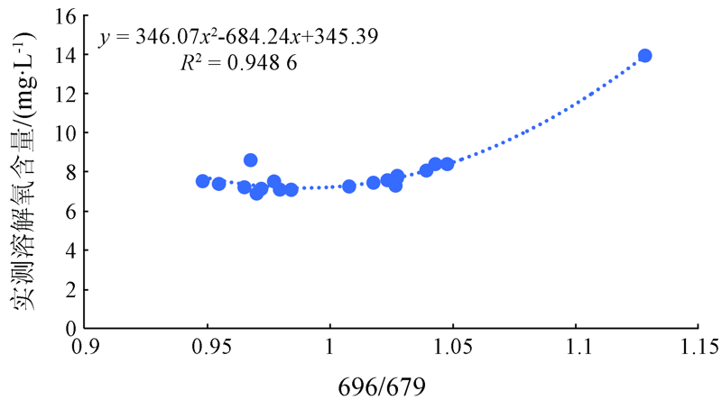
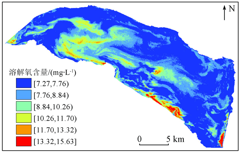
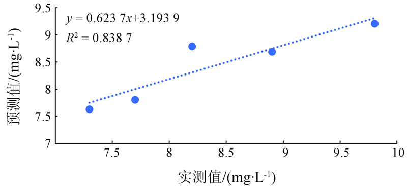
The studies on the hyperspectral inversion of salt lakes are still scarce due to the limitations of geographical conditions at present. This study explores the inversion ideas and methods of the water quality parameters of salt lakes by taking the dissolved oxygen inversion of a salt lake as an example. Based on the analyses of the hyperspectral data of the Chaerhan Salt Lake in Qinghai Province and the hyperspectral inversion technology of water quality parameters, this study determined the hyperspectral inversion model of the dissolved oxygen in the salt lake by means of waveband combination using the unique spectral information of the water body of the lake. The results show that the correlation coefficient between various wavebands of the original spectrum curve and the dissolved oxygen content was less than 0.3, while that between the band combination data in the unique spectral information of the water body and the dissolved oxygen content was greater than 0.75. According to the precision verification of the finally established band ratio model using the measured value, the inversion result of the dissolved oxygen content was roughly consistent with the measured value. It is impossible for the water quality parameters to significantly change with time owing to the relatively stable nature of the water body of the salt lake. Therefore, the verification using the measured data of November 2019 can also indicate that the waveband ratio model established based on the spectral characteristics of the salt lake enjoys high precision for a long term. Therefore, the hyperspectral inversion model can meet the precision requirements for the large-area monitoring of the dissolved oxygen in the lake area. Meanwhile, this study also proposed a new idea for the establishment of the inversion model of plateau salt lakes, which lays a foundation for the establishment of the monitoring system of plateau lakes in the future.
杜程, 李得林, 李根军, 杨雪松. 基于高原盐湖光谱特性下的溶解氧反演应用与探讨[J]. 自然资源遥感, 2021, 33(3): 246-252.
DU Cheng, LI Delin, LI Genjun, YANG Xuesong. Application and exploration of dissolved oxygen inversion of plateau salt lakes based on spectral characteristics. Remote Sensing for Natural Resources, 2021, 33(3): 246-252.
Liu G X, Li C J. Discussion on the development and utilization of salt lake resources in Qinghai Province[J]. Journal of Qinghai Homeland Economic Strategy, 2019(2):22-26.
Suo H X, He G, Mao Y M. The status quo,problems and countermeasures of comprehensive development and utilization of salt lake resources in Qinghai[J]. Climbing Magazine, 2006(5):72-74.
Zhu Y L. Research on remote sensing monitoring and evaluation methods of lake water quality[D]. Beijing:Graduate School of Chinese Academy of Sciences(Institute of Remote Sensing Applications), 2006.
[4]
江辉. 基于多源遥感的鄱阳湖水质参数反演与分析[D]. 南昌:南昌大学, 2011.
Jiang H. Inversion and analysis of water quality parameters of Poyang Lake based on multi-source remote sensing[D]. Nanchang:Nanchang University, 2011.
Song T, Zhou W L, Liu J Z, et al. Evaluation of Chlorophyll a concentration distribution in Taihu Lake using hyperspectral inversion model[J]. Acta Scientiae Circumstantiae, 2017, 37(3):888-899.
Chen Y, Huang C P, Zhang L F, et al. Analysis of water COD spectral characteristics and construction of remote sensing inversion model[J]. Spectroscopy and Spectral Analysis, 2020, 40(3):824-830.
Wang B, An H J, Lyu C W. Retrieval model of dissolved oxygen in Hulun Lake based on multi-source remote sensing data[J]. Functional Ecology, 2013, 32(4):993-998.
Zhou Y M, Zhang R Q, Ma H Y, et al. Retrieving of salt lake mineral ions salinity from hyperspectral data based on BP neural network[J]. Remote Sensing for Land and Resources, 2016, 28(2):34-40.doi: 10.6046/gtzyyg.2016.02.06.
doi: 10.6046/gtzyyg.2016.02.06
 2021, Vol. 33
  ), 李得林1,2,3(