Estimation accuracy of fractional vegetation cover based on normalized difference vegetation index and UAV hyperspectral images
LIU Yongmei1,2(), FAN Hongjian1, GE Xinghua1, LIU Jianhong1,2, WANG Lei1,2
1. College of Urban and Environmental Science, Northwest University, Xi’an 710127, China 2. Shaanxi Key Laboratory of Surface System and Environmental Carrying Capacity, Xi’an 710127, China
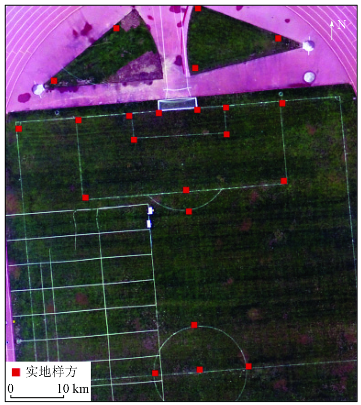
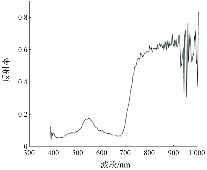
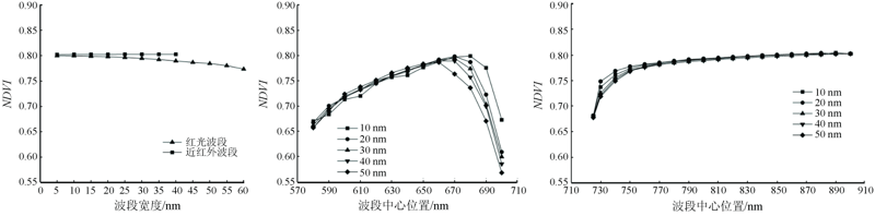
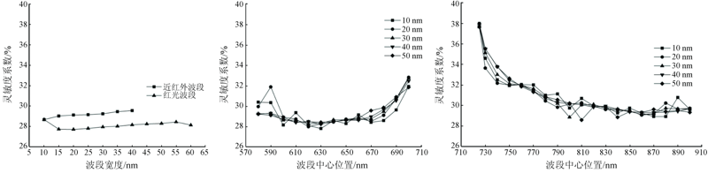
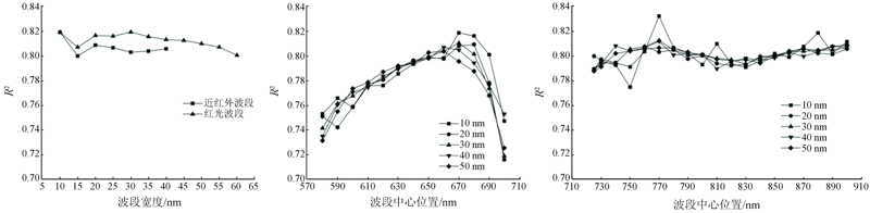
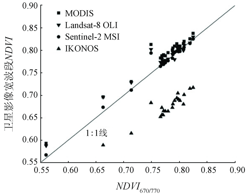
The researches on the effects of band parameters on the biophysical parameters of vegetation estimation using the normalized difference vegetation index (NDVI) have great significance for the improvement in the application accuracy of NDVI in vegetation dynamic monitoring. Based on the hyperspectral images of artificial grassland obtained from a Resonon, Inc. Pika XC2 Hyperspectral Imaging Camera loaded by an unmanned aerial vehicle (UAV), this study analyzes the effects of the positions and width of red and near-infrared bands on NDVI and assesses the sensitivity of NDVI to fractional vegetation cover and the estimation accuracy. The results are as follows. When band positions were fixed, the width expansion of red and near-infrared bands had little effects on NDVI and its sensitivity, and the accuracy of fractional vegetation cover estimated using narrowband NDVI is higher than the accuracy based on broadband NDVI. When the red and near-infrared bands moved towards long waves, the NDVI and its sensitivity were affected to different extents. With an increase in the sensitivity, the anti-disturbance performance of NDVI decreased, and the estimation accuracy of fractional vegetation cover decreased. The sensitivity coefficient of narrowband NDVI and the R2 determined by the linear fitting of the sensitivity coefficient and the fractional vegetation cover greatly fluctuated, and the estimated fractional vegetation cover at various locations was unstable. High estimation accuracy of fractional vegetation was obtained at different locations using the 10 nm NDVI, with the maximum R2 value of 0.83. The broadband NDVI calculated using four popular satellite images can be well applied in the inversion of the fractional vegetation cover in areas with high vegetation cover. However, its inversion accuracy of fractional vegetation cover still suffered some attenuation compared with narrowband NDVI (10 nm). These results will serve as scientific references and bases for accurate inversion of vegetation parameters using NDVI.
刘咏梅, 范鸿建, 盖星华, 刘建红, 王雷. 基于无人机高光谱影像的NDVI估算植被盖度精度分析[J]. 自然资源遥感, 2021, 33(3): 11-17.
LIU Yongmei, FAN Hongjian, GE Xinghua, LIU Jianhong, WANG Lei. Estimation accuracy of fractional vegetation cover based on normalized difference vegetation index and UAV hyperspectral images. Remote Sensing for Natural Resources, 2021, 33(3): 11-17.
Tian Q J, Min X J. Advances in study on vegetation indices[J]. Advance in Earth Sciences, 1998, 13(4):327-333.
[2]
Rouse J W, Haas R H, Schell J A, et al. Monitoring vegetation systems in the Great Plains with ERTS. Proceedings,3rd Earth Resource Technology Satellite (ERTS) Symposium, 1974(1):48-62.
Li Z, Hu D, Zhao D Z, et al. Research advance of broadband vegetation index using remotely sensed images[J]. Journal of Yangtze River Scientific Research Institute, 2015, 32(1):125-130.
Wang F M, Huang J F, Wang X Z, et al. Effects of band position and bandwidth on NDVI measurements of rice at different growth stages[J]. Journal of Remote Sensing, 2008, 12(4):626-632.
Wang Z X, Liu C, Huete Alfredo. From AVHRR-NDVI to MODIS-EVI:Advances in vegetation index research[J]. Acta Ecologica Sinica, 2003, 23(5):979-987.
[6]
Teillet P M, Staenz K, William D J. Effects of spectral,spatial,and radiometric characteristics on remote sensing vegetation indices of forested regions[J]. Remote Sensing of Environment, 1997, 61(1):139-149.
doi: 10.1016/S0034-4257(96)00248-9
[7]
Galvao L S, Vitorello I, Filho R A. Effect of band positioning and bandwidth on NDVI measurements of Tropical Savannas[J]. Remote Sensing of Environment, 1999, 67:181-193.
doi: 10.1016/S0034-4257(98)00085-6
[8]
Galvao L S, Vitorello I, Pizarro M A. An adequate band positioning to enhance NDVI contrasts among green vegetation,senescent biomass,and tropical soils[J]. International Journal of Remote Sensing, 2000, 21(9):1953-1960.
doi: 10.1080/014311600209878
Lin X B, He S, Lin X, et al. Effects of band position and bandwidth on NDVI measurements of four kinds of estuary wetland vegetation[J]. Remote Sensing Technology and Application, 2013, 8(4):714-720.
Wang F M, Huang J F, Tang Y L, et al. Estimation of rice LAI by using NDVI at different spectral bandwidths[J]. Chinese Journal of Applied Ecology, 2007, 18(11):2444-2450.
[11]
Du H S, Jiang H L, Zhang L F, et al. Evaluation of spectral scale effects in estimation of vegetation leaf area index using spectral indices methods[J]. Chinese Geographical Science, 2016, 26(6):731-744.
doi: 10.1007/s11769-016-0833-y
Huang T, Liang L, Geng D, et al. Effects of band width on estimation of wheat LAI using vegetation index[J]. Transactions of the Chinese Society of Agricultural Engineering (Transactions of the CSAE), 2020, 36(4):168-177.
Jia K, Yao Y J, Wei X Q, et al. 2013. A review on fractional vegetation cover estimation using remote sensing[J]. Advance in Earth Sciences, 2013, 28(7):774-782.
[14]
Liu F, Wang X C, Wang C K. Measuring vegetation phenology with near-surface remote sensing in a temperate deciduous forest:Effects of sensor type and deployment remote sensing[J]. Remote Sensing, 2019(11):1063.
Wang F L, Wang F M, Hu J H, et al. Estimating and mapping rice yield using UAV-hyperspectral imager based relative spectral variates[J]. Remote Sensing Technology and Application, 2020, 35(2):458-468.
Tao H L, Feng H K, Yang G J, et al. Comparison of winter wheat yields estimated with UAV digital image and hyperspectral data[J]. Transactions of the Chinese Society of Agricultural Engineering, 2019, 35(23):111-118.
[17]
Ji L, Albert J P. Performance evaluation of spectral vegetation indices using a statistical sensitivity function[J]. Remote Sensing of Environment, 2007, 106(1):59-65.
doi: 10.1016/j.rse.2006.07.010
[18]
Vincini M, Frazzi E. Comparing narrow and broad-band vegetation indices to estimate leaf chlorophyll content in planophile crop canopies[J]. Precision Agriculture, 2011, 12(3):334-344.
doi: 10.1007/s11119-010-9204-3
[19]
Huemmrich K F, Black T A, Jarvis P G, et al. High temporal resolution NDVI phenology from micrometeorological radiation sensors[J]. Journal of Geophysical Research, 1999, 104(22):27935-27944.
doi: 10.1029/1999JD900164
 2021, Vol. 33
  ), 范鸿建1, 盖星华1, 刘建红1,2, 王雷1,2