Application of high-resolution remote sensing technology to research into active faults in the Maoyaba area, western Sichuan Province
YIN Tao(), SONG Yuanbao, ZHANG Wei, YUAN Huayun
Evaluation and Utilization of Strategic Rare Metals and Rare Earth Resource Key Laboratory of Sichuan Institute of Comprehensive Geological Survey, Chengdu 610081, China
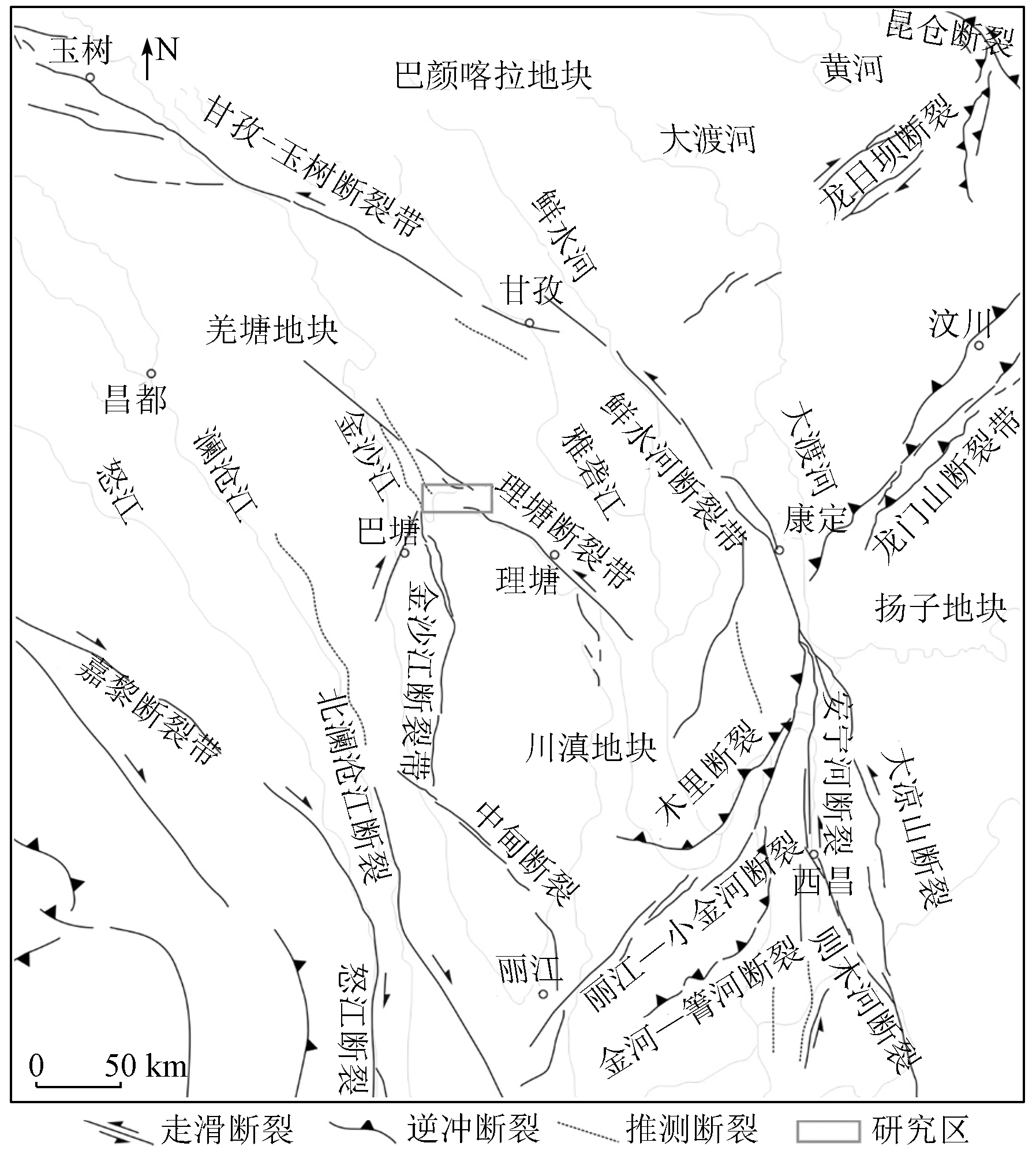
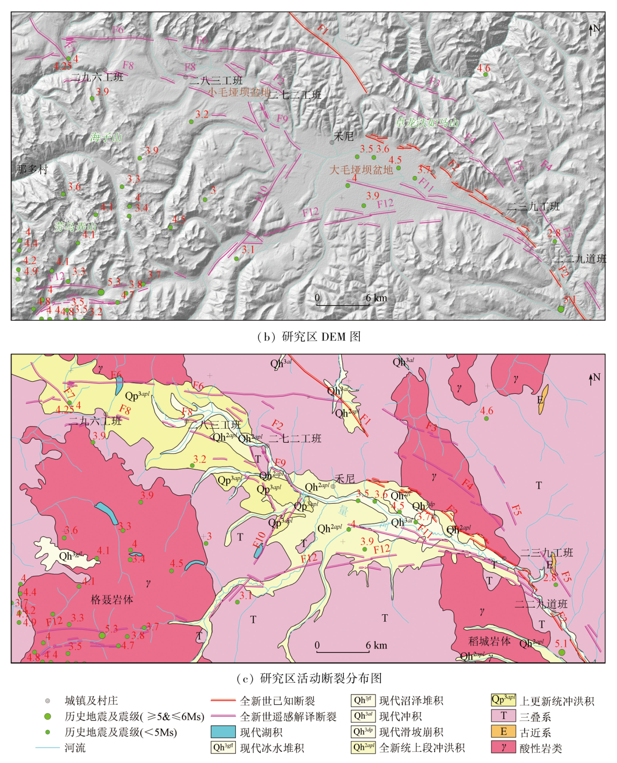
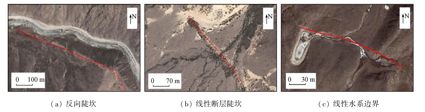
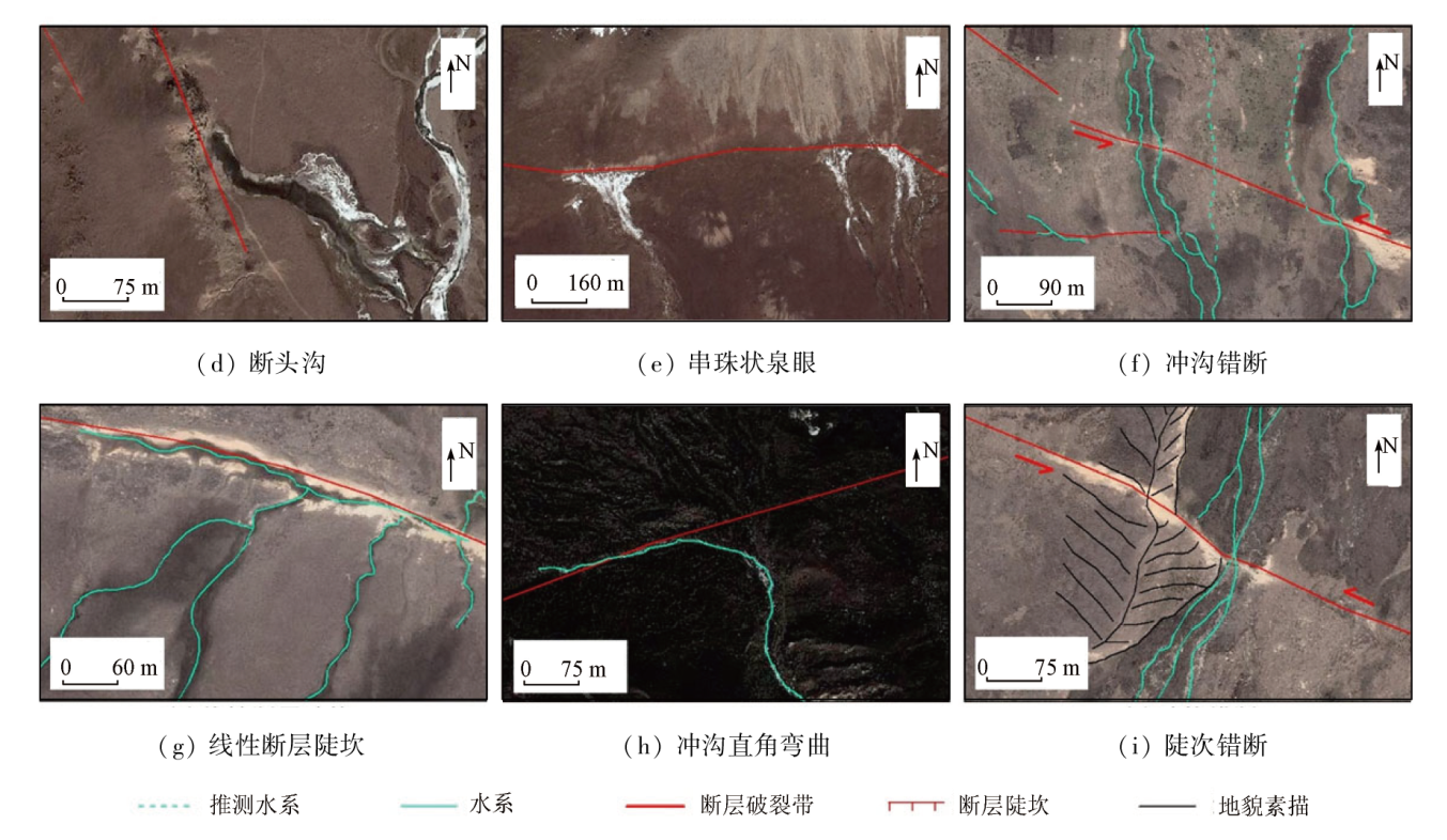
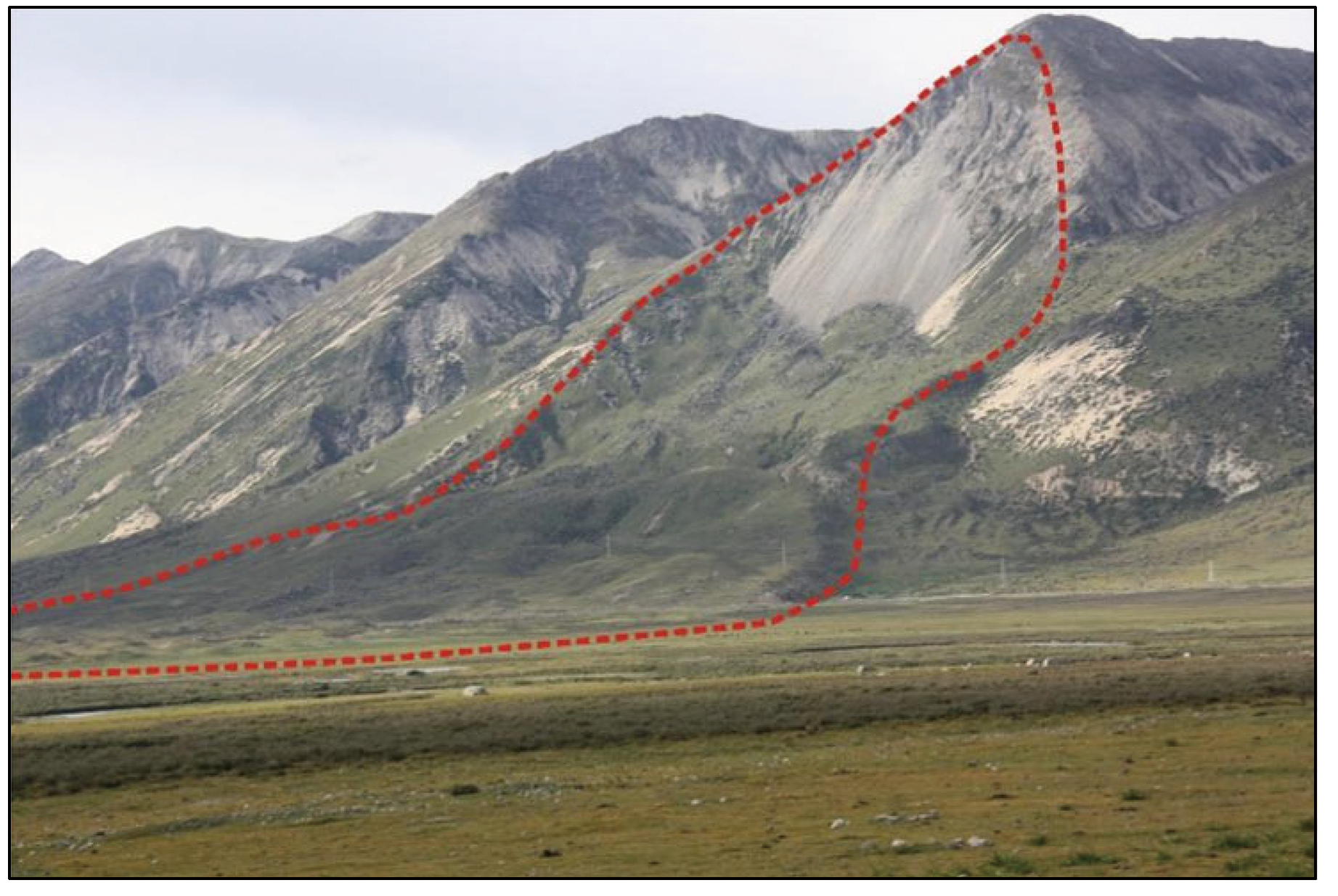
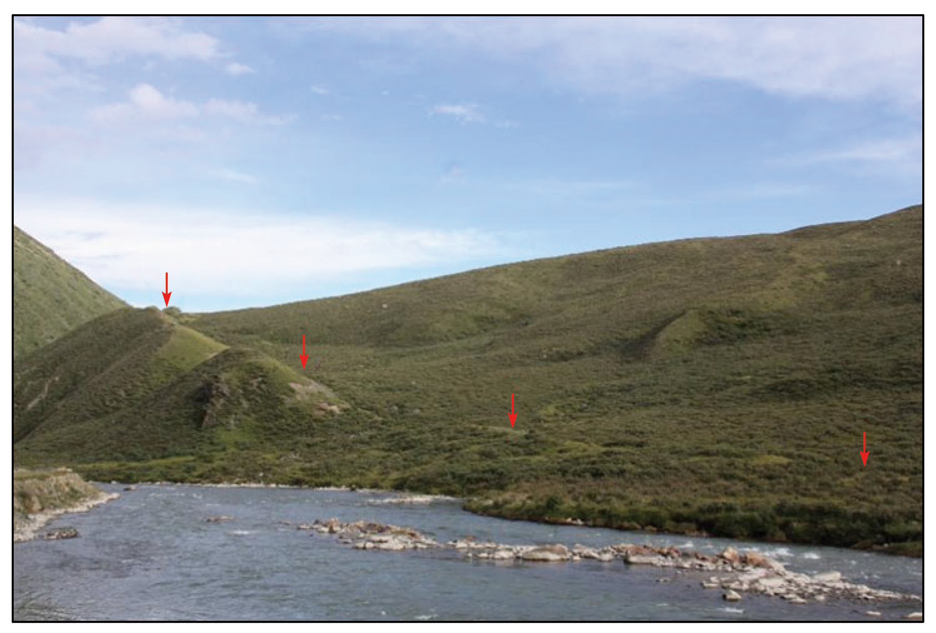
High-resolution remote sensing technology can greatly enhance the efficiency of investigations into active faults due to its high ability to identify the fine structures of microlandforms. This study presents a systematic summary of the symbols of remote sensing images for active faults. By comprehensively utilizing data from the Landsat8 and GF-2 satellites, as well as previous results and field geological surveys, this study analyzed and examined the active faults in the Maoyaba area of western Sichuan Province through the interpretation of remote sensing images of both macro- and microlandforms. The results show that, besides the Yidun-Litang fault zone, several nearly-W-E-trending normal active faults occur in the study area. Based on this finding, as well as the analysis of the regional geological setting, it can be concluded that crustal materials along the southeastern margin of the Qinghai-Tibet Plateau were continuously squeezed out laterally under the background of the intense collision and compression between the Indian and Eurasian plates, leading to the formation of two conjugate faults: the dextral Batang strike-slip fault and the sinistral Litang strike-slip fault. The joint control of both faults resulted in the local extension of the study area and the formation of nearly-W-E-trending fault structures, which govern the development and evolution of the Damaoyaba Basin, the Xiaomaoyaba Basin, and the Cuopu Basin in the north.
尹滔, 宋元宝, 张伟, 袁华云. 高分辨率遥感技术在川西毛垭坝地区活动断裂研究中的应用[J]. 自然资源遥感, 2024, 36(3): 174-186.
YIN Tao, SONG Yuanbao, ZHANG Wei, YUAN Huayun. Application of high-resolution remote sensing technology to research into active faults in the Maoyaba area, western Sichuan Province. Remote Sensing for Natural Resources, 2024, 36(3): 174-186.
Arrowsmith J R, Zielke O. Tectonic geomorphology of the San Andreas fault zone from high resolution topography:An example from the Cholame segment[J]. Geomorphology, 2009, 113(1/2):70-81.
[2]
Klinger Y, Etchebes M, Tapponnier P, et al. Characteristic slip for five great earthquakes along the Fuyun fault in China[J]. Nature Geoscience, 2011, 4:389-392.
Zhang J F, Jiang W L, Tian T, et al. High resolution remote sensing application research in active fault surveying[J]. Acta Seismologica Sinica, 2016, 38(3):386-398,508.
Jiang W L, Zhang J F, Shen X H, et al. Geometric and geomorphic features of active fault structures interpreted from high-resolution remote sensing data[J]. National Remote Sensing Bulletin, 2018, 22(s1):192-211.
He H L. Some problems of aerial photo interpretation in active fault mapping[J]. Seismology and Geology, 2011, 33(4):938-950.
doi: 10.3969/j.issn.0253-4967.2011.04.017
Cheng J, Xu X W, Gan W J, et al. Block model and dynamic implication from the earthquake activities and crustal motion in the southeastern margin of Tibetan Plateau[J]. Chinese Jourmal of Geophysics, 2012, 55(4):1198-1212.
Wang Y Z, Wang E N, Shen Z K, et al. Inversion of current active rate of main faults in Sichuan-Yunnan area based on GPS data constraints[J]. Science in China (Series D (Earth Sciences)), 2008, 38(5):582-597.
[10]
唐荣昌, 韩渭宾. 四川活动断裂与地震[M]. 北京: 地震出版社, 1993.
Tang R C, Han W B. Active faults and earthquakes in Sichuan Province[M]. Beijing: Seismological Press, 1993.
Xu X W, Zhang P Z, Wen X Z, et al. Features of active tectonics and recurrence behaviors of strong earthquakes in the western Sichuan Province and its adjacent regions[J]. Seismology and Geology, 2005, 27(3):446-461.
Zhou R J, Chen G X, Li Y, et al. Research on active faults in Litang-Batang Region,western Sichuan Province,and the seismogenic structures of the 1989 Batang M6.7 earthquake swarm[J]. Seismology and Geology, 2005, 27(1):31-43.
Zhou C J, Wu Z H, Zhang K Q, et al. New chronological constraint on the co-seismic surface rupture segments associated with the Litang fault[J]. Seismology and Geology, 2015, 37(2):455-467.
doi: 10.3969/j.issn.0253-4967.2015.02.009
Hou Z Q, Yang Y Q, Qu X M, et al. Tectonic evolution and mineralization systems of the yidun arc orogen in Sanjiang Region,China[J]. Acta Geologica Sinica, 2004, 78(1):109-120.
Zhou R J, Liu S, Li Y, et al. Earthquake surface rupture and recurrence interval of large earthquakes in Damaoyaba-Litang section of Litang fault[C]. Proceedings of Annual Meeting of Chinese Geoscience Unioin, 2016:677-678.
Ma D, Wu Z H, Li J C, et al. Geometric distribution and the quaternary activity of Litang active fault zone based on remote sensing[J]. Acta Geologica Sinica, 2014, 88(8):1417-1435.
[18]
赵国华. 川滇块体内理塘断裂活动性及其构造地貌研究[D]. 成都: 成都理工大学, 2014.
Zhao G H. Study on fault activity and tectonic geomorphology of Litang fault within the Chuandian Blocks[D]. Chengdu: Chengdu University of Technology, 2014.
Zhang Y Z. Tectonic chronology constraint on the main faults bounding the East Sichuan-Yunnan Block and implications for Tibetan Plateau kinetics[D]. Wuhan: China University of Geosciences, 2015.
Guo C B, Du Y B, Tong Y Q, et al. Huge long-runout landslide characteristics and formation mechanism:A case study of the Luanshibao landslide,Litang County,Tibetan Plateau[J]. Geological Bulletin of China, 2016, 35(8):1332-1345.
[21]
Chevalier M L, Leloup P H, Replumaz A, et al. Tectonic-geomorphology of the Litang fault system,SE Tibetan Plateau,and implication for regional seismic hazard[J]. Tectonophysics, 2016, 682:278-292.
Zhang D, Wu Z H, Li J C, et al. The delineation of three-dimensional shallow geometry of active fault based on TLS and GPR:A case study of a normal fault on the north margin of Maoyaba Basin in Litang,western Sichuan Province[J]. Seismology and Geology, 2019, 41(2):377-399.
Cao Y Y, Huang T, Yin X K, et al. Shallow seismic explorations on unfavorable geological bodies in the Maoyaba Basin of the Litang section of the Sichuan-Tibet Railway[J]. Progress in Geophysics, 2022, 37(2):774.
[24]
Xu X W, Wen X Z, Yu G H, et al. Average slip rate,earthquake rupturing segmentation and recurrence behavior on the Litang fault zone,western Sichuan Province,China[J]. Science in China Series D Earth Sciences, 2005, 48(8):1183-1196.
Liu K, Li Y F, Guo H W, et al. Determination of surface rupture length and analysis of Riedel shear structure of the Litang M7.3 earthquake in west Sichuan in 1948[J]. Acta Geologica Sinica, 2021, 95(8):2346-2360.
Zhang K Q, Wu Z H, Zhou C J, et al. Paleo earthquake events and inhomogeneous activity characteristics in the Benge- Cunge section of the Litang fault zone in the western Sichuan Province[J]. Acta Geologica Sinica, 2020, 94(4):1295-1303.
RenJ J, XuX W, KangW J, et al. Holocene paleoearthquake history and large earthquake recurrence behavior of Maoyaba fault in Litang fault zone[C]// Proceedings of Annual Meeting of Chinese Geoscience Unioin, 2020:24.
[28]
Holt W E, Ni J F, Wallace T C, et al. The active tectonics of the eastern Himalayan syntaxis and surrounding regions[J]. Journal of Geophysical Research:Solid Earth, 1991, 96(B9):14595-14632.
[29]
Wang E, Burchfiel B C. Interpretation of Cenozoic tectonics in the right-lateral accommodation zone between the Ailao Shan shear zone and the eastern Himalayan syntaxis[J]. International Geology Review, 1997, 39:191-219.
Zhang P Z, Wang Q, Ma Z J. GPS velocity field and active crustal deformation in and around the Qinghai-Tibet Plateau[J]. Earth Science Frontiers, 2002, 9(2):442-450.
[31]
Socquet A, Pubellier M. Cenozoic deformation in western Yunnan (China-Myanmar border)[J]. Journal of Asian Earth Sciences, 2005, 24(4):495-515.
Wu Z H, Long C X, Fan T Y, et al. The arc rotational-shear active tectonic system on the southeastern margin of Tibetan Plateau and its dynamic characteristics and mechanism[J]. Geological Bulletin of China, 2015, 34(1):1-31.
[33]
Gan W J, Zhang P Z, Shen Z K, et al. Present-day crustal motion within the Tibetan Plateau inferred from GPS measurements[J]. Journal of Geophysical Research:Solid Earth, 2007, 112(B8):B08416.
[34]
张清林. 川西巴塘地区断裂构造变形研究[D]. 成都: 成都理工大学, 2016.
Zhang Q L. Study on deformation of faults in Batang region in Western Sichuan[D]. Chengdu: Chengdu University of Technology, 2016.
 2024, Vol. 36
  ), 宋元宝, 张伟, 袁华云