Please wait a minute...
 
自然资源遥感  2022, Vol. 34 Issue (3): 227-234    DOI: 10.6046/zrzyyg.2021308
  技术应用 本期目录 | 过刊浏览 | 高级检索 |
基于真实感场景影像的天陇铁路勘察遥感解译与分析
刘亚林()
中铁第一勘察设计院集团有限公司,西安 710043
Remote sensing interpretation and analysis of the survey of the Tianshui-Longnan Railway based on realistic scene images
LIU Yalin()
China Railway First Survey and Design Institute Group Co., Ltd., Xi’an 710043, China
全文: PDF(14416 KB)   HTML  
输出: BibTeX | EndNote (RIS)      
摘要 

天陇铁路作为甘肃省委省政府“巩固东连、向西为主,深耕南向、促进北拓”发展战略的重要保障工程,两次翻越秦岭山脉,由北至南途经黄土梁峁沟壑区、天水—西礼盆地中山区、秦岭中山区等3个特征迥异地貌单元,地质构造背景复杂,区域新生代构造活动强烈,沿线存在大规模滑坡群、全新世活动断裂、岩溶塌陷等环境地质问题,严重制约了前期线路方案设计,并影响后期铁路施工运营的安全稳定。该研究充分利用实测航飞遥感数据,通过真实感场景高精度立体影像及正射影像对全线各类地质问题开展了详细的解译分析,结合现场调查资料,对其范围、规模、稳定性以及可能对线路方案产生的影响进行了评价,研究成果为线路方案设计及外业地质勘察提供了有力的遥感技术支撑。

服务
把本文推荐给朋友
加入引用管理器
E-mail Alert
RSS
作者相关文章
刘亚林
关键词 遥感技术真实感场景天陇铁路滑坡活动断裂岩溶    
Abstract

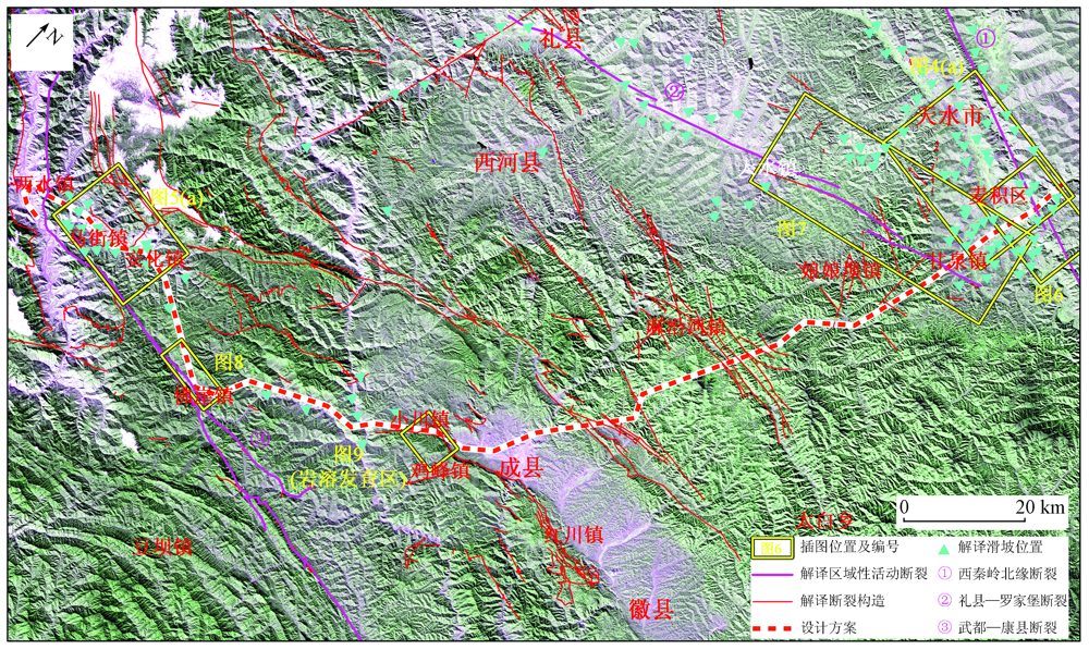
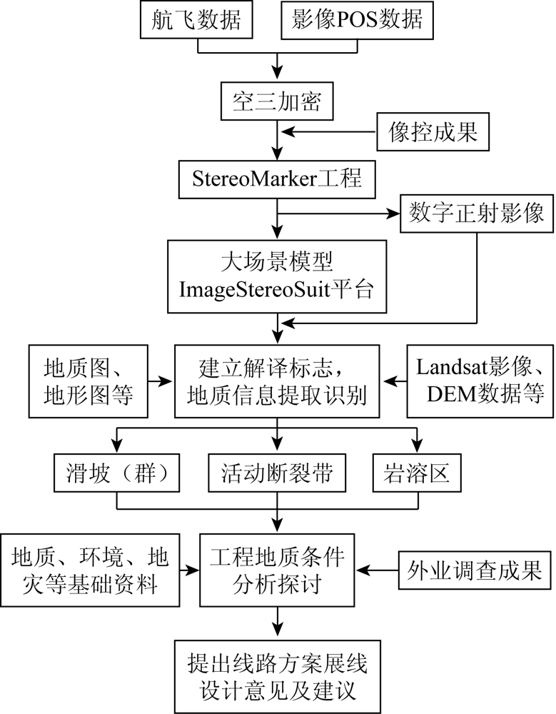
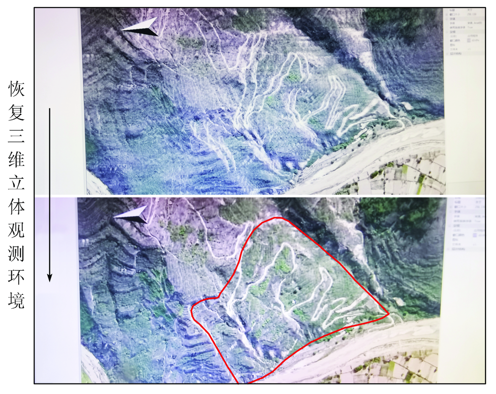
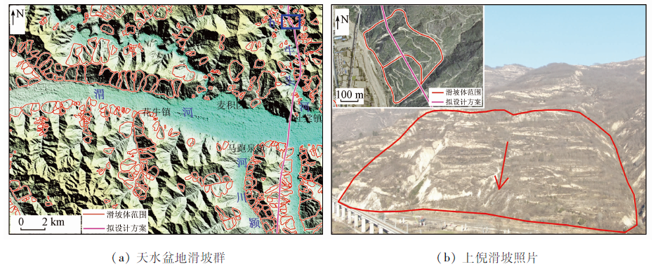
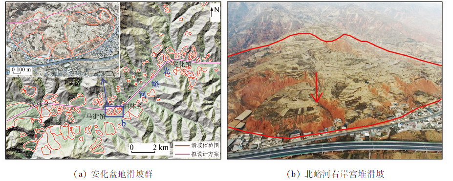
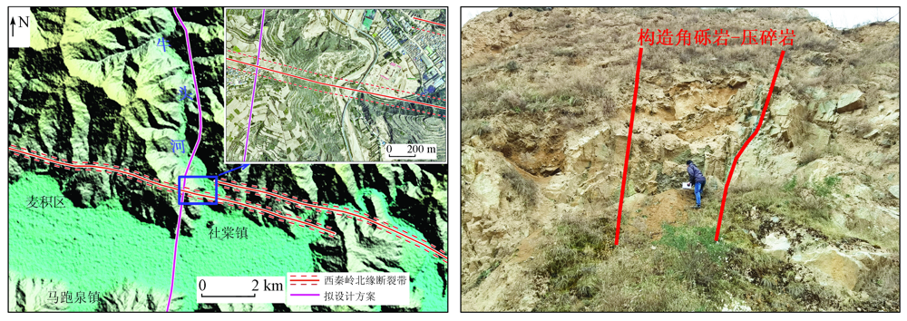
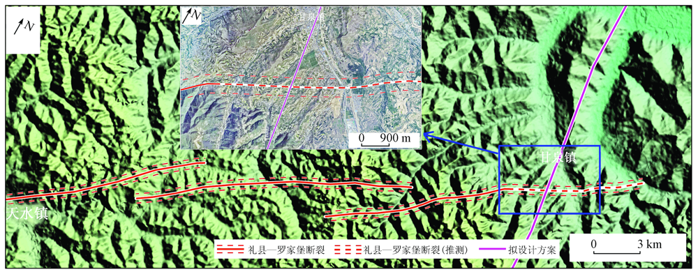
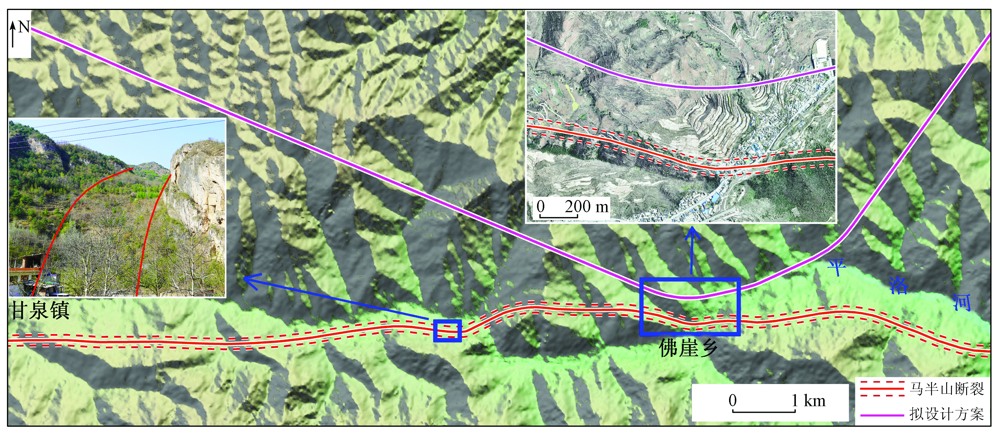
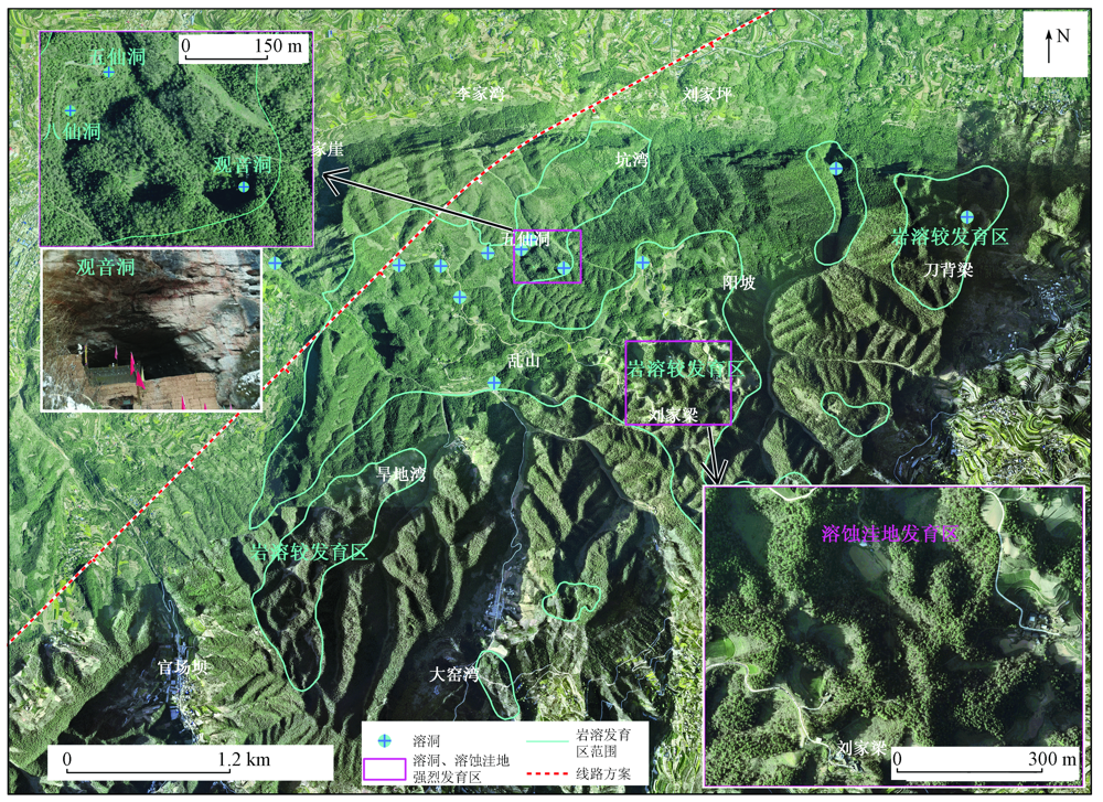
The Tianshui-Longnan Railway serves as an important project for guaranteeing Gansu Province’s development strategy of “consolidating the east, focusing on the west, deepening the south, and promoting the northward expansion”. This railway crosses the Qinling Mountains twice and passes through three distinct geomorphic units including the loess ridge, knoll, and gully areas, the moderately high mountainous area of the Tianshui-Xili basin, and the moderately high mountainous area of the Qinling Mountains from north to south. The complex geological tectonic setting and the intensive regional Cenozoic tectonic movements lead to environmental geological problems, such as large-scale landslide groups, Holocene active faults, and karst collapse along the railway line, which severely restrain the early-stage design of the line scheme and affect the safety and stability of the later construction and operation of the railway. By fully utilizing surveyed aerial remote sensing data, this study interpreted and analyzed various geological problems along the whole railway in detail according to high-precision stereo images and orthophoto images of realistic scenes. Moreover, this study assessed the scope, scale, stability, and possible impacts of the various geological problems on the line scheme by combining the data from field surveys. The results of this study will provide strong technical support for both the line scheme design and the field geological surveys of the Tianshui-Longnan Railway.

Key wordsremote sensing technology    realistic scene    Tianshui-Longnan Railway    landslide    active fault    karst
收稿日期: 2021-09-27      出版日期: 2022-09-21
ZTFLH:  TP79  
基金资助:中铁第一勘察设计院集团有限公司重点专项研发项目“铁路智能勘测及数据管理关键技术研究”(2021KY73ZD(ZDZX)-1)
作者简介: 刘亚林(1982-),男,硕士,高级工程师,主要从事遥感技术应用研究。Email: lynn6100@126.com
引用本文:   
刘亚林. 基于真实感场景影像的天陇铁路勘察遥感解译与分析[J]. 自然资源遥感, 2022, 34(3): 227-234.
LIU Yalin. Remote sensing interpretation and analysis of the survey of the Tianshui-Longnan Railway based on realistic scene images. Remote Sensing for Natural Resources, 2022, 34(3): 227-234.
链接本文:  
https://www.gtzyyg.com/CN/10.6046/zrzyyg.2021308      或      https://www.gtzyyg.com/CN/Y2022/V34/I3/227
Fig.1  研究区遥感影像图
Fig.2  真实感场景地质遥感解译分析技术流程
Fig.3  真实感场景三维解译观测环境
Fig.4  天水盆地滑坡群影像及典型滑坡照片
Fig.5  安化盆地滑坡群影像及典型滑坡照片
Fig.6  西秦岭北缘断裂影像及照片
Fig.7  礼县—罗家堡断裂遥感影像
Fig.8  武都—康县断裂(马半山断裂)影像及照片
Fig.9  鸡峰山岩溶较发育区影像特征
[1] 卓宝熙, 甄春相. 遥感技术在铁路工程地质勘察中的应用[J]. 铁道工程学报, 2005, 12(s1):398-406.
Zhuo B X, Zhen C X. Application of remote sensing technology in the railway engineering geology[J]. Journal of Railway Engineering Society, 2005, 12(s1):398-406.
[2] 贾伟洁, 王治华. 基于高分辨率遥感影像的滑坡活动特征及稳定性分析——以东苗家滑坡为例[J]. 国土资源遥感, 2019, 31(4):174-181.doi: 10.6046/gtzyyg.2019.04.23.
doi: 10.6046/gtzyyg.2019.04.23
Jia W J, Wang Z H. Landslide activity characteristics and stability analysis based on high-resolution remote sensing image:A case study of Dongmiaojia landslide[J]. Remote Sensing for Land and Resources, 2019, 31(4):174-181.doi: 10.6046/gtzyyg.2019.04.23.
doi: 10.6046/gtzyyg.2019.04.23
[3] 夏涛, 杨武年, 马安青. 遥感影像三维可视化在岩溶漏斗解译中的应用[J]. 测绘科学, 2009(6):266-267.
Xia T, Yang W N, Ma A Q. Application of 3D visualization of remote sensing images in doline interpretation[J]. Science of Surveying and Mapping, 2009(6):266-267.
[4] 赵卫东, 郑勇, 章浩南, 等. 基于多源数据的郯庐断裂带安徽段遥感解译及其空间分布特征[J]. 国土资源遥感, 2019, 31(4):79-87.doi: 10.6046/gtzyyg.2019.04.11.
doi: 10.6046/gtzyyg.2019.04.11
Zhao W D, Zhen Y, Zhang H N, et al. Remote sensing interpretation and spatial distribution characteristics of the Anhui segment of Tanlu fault zone based on multi-source data[J]. Remote Sensing for Landand Resources, 2019, 31(4):79-87.doi: 10.6046/gtzyyg.2019.04.11.
doi: 10.6046/gtzyyg.2019.04.11
[5] 刘亚林. 多源遥感技术在铁路工程地质勘察中的应用研究[J]. 铁道标准设计, 2013(5):13-15.
Liu Y L. Application research of multisource remote sensing technology in railway geological surveying[J]. Railway Standard Design, 2013(5):13-15.
[6] 张占忠. 铁路大场景立体影像模型制作关键技术及应用[J]. 铁道工程学报, 2020, 37(4):11-16.
Zhang Z Z. Key Technologies for making large scene stereo model and its application in railway survey and design[J]. Journal of Railway Engineering Society, 2020, 37(4):11-16.
[7] 吕慧玲. 真实感场景模型制作工艺及质量控制方法[J]. 铁道标准设计, 2016(9):28-31.
Lyu H L. Workmanship and quality control of realistic scene model[J]. Railway Standard Design, 2016(9):28-31.
[8] 孟祥连, 周福军. 真实感场景遥感技术在铁路工程勘察中的应用[J]. 西南交通大学学报, 2017, 52(5):949-955.
Meng X L, Zhou F J. Application of railway engineering survey based on remote sensing technology for realistic scenes[J]. Journal of Southwest Jiaotong University, 2017, 52(5):949-955.
[9] 田尤, 杨为民, 黄晓, 等. 天水市麦积区幅黄土滑坡发育分布特征及其孕灾因素分析[J]. 地质力学学报, 2016, 22(1):25-38.
Tian Y, Yang W M, Huang X, et al. Distribution characteristics and inducing factors of loess landslide in Maiji mappablen unit,Tianshui[J]. Journal of Geomechanics, 2016, 22(1):25-38.
[10] 王志才, 张培震, 张广良, 等. 西秦岭北缘构造带的新生代构造活动——兼论对青藏高原东北缘形成过程的指示意义[J]. 地学前缘, 2006, 13(4):119-135.
Wang Z C, Zhang P Z, Zhang G L, et al. Tertiary tectonic activities of the north frontal fault zone of the west Qinling Mountains:Implications for the growth of the northeastern margin of the Qinghai-Tibetan Plateau[J]. Earth Science Frontiers, 2006, 13(4):119-135.
[11] 杨晓平, 冯希杰, 黄雄南, 等. 礼县—罗家堡断裂晚第四纪活动特征:兼论1654年礼县8级地震孕震机制[J]. 地球物理学报, 2015, 58(2):504-519.
Yang X P, Feng X J, Huang X N, et al. The late quaternary activity characteristics of the Lixian-Luojiabu fault:A discussion on the seismogenic mechanism of the Lixian M8 earthquake in 1654[J]. Chinese Journal of Geophysics, 2015, 58(2):504-519.
[12] 陈鹏. 西秦岭地区晚新生代构造演化[D]. 北京: 中国地质科学院, 2016.
Chen P. Late cenozoic tectonic evolution in the west Qinling areasa case study of Tianshui basin[D]. Beijing: Chinese Academy of Geological Sciences, 2016.
[13] 贾伟. 康县—武都断裂新活动性及其地震危险性研究[D]. 兰州: 中国地震局兰州地震研究所, 2012.
Jia W. Activity on Kangxian-Wudu fault zone and its’seismic hazard assessment[D]. Lanzhou: Lanzhou Institute of Seismology,CEA, 2012.
[14] 张帅, 孙萍, 邵铁全, 等. 甘肃天水黄土梁峁区强震诱发滑坡特征研究[J]. 工程地质学报, 2016, 24(4):519-526.
Zhang S, Sun P, Shao T Q, et al. Earthquake-Triggered landslides in Tianshui loess hilly region,Gansu Province,China[J]. Journal of Engineering Geology, 2016, 24(4):519-526.
[15] 匡永生. 秦安—天水地区新生代盆地沉积演化[D]. 兰州: 兰州大学, 2007.
Kuang Y S. The depositional evolution of neozoic basin in Tianshui-Qin’an area[D]. Lanzhou: Lanzhou University, 2007.
[1] 朱博勤, 严召进, 谢晶, 刘宏, 宋小庆, 向喜琼. FAST型大射电望远镜选址洼地地形搜寻关键技术研究[J]. 自然资源遥感, 2023, 35(2): 80-88.
[2] 李晨辉, 郝利娜, 许强, 王一, 严丽华. 面向对象的高分辨率遥感影像地震滑坡分层识别[J]. 自然资源遥感, 2023, 35(1): 74-80.
[3] 张雨, 明冬萍, 赵文祎, 徐录, 赵治, 刘冉. 基于高分光学卫星影像的泸定地震型滑坡提取与分析[J]. 自然资源遥感, 2023, 35(1): 161-170.
[4] 贺鹏, 颜瑜严, 文艳, 马志刚, 焦其松, 郭兆成, 莫悠. 机载LiDAR技术在缓倾地层滑坡及其拉裂槽识别中的应用[J]. 自然资源遥感, 2022, 34(4): 307-316.
[5] 董继红, 马志刚, 梁京涛, 刘彬, 赵聪, 曾帅, 鄢圣武, 马晓波. 基于时序InSAR技术的滑坡隐患识别对比研究[J]. 自然资源遥感, 2022, 34(3): 73-81.
[6] 杨昭颖, 韩灵怡, 郑向向, 李文吉, 冯磊, 王轶, 杨永鹏. 基于卷积神经网络的遥感影像及DEM滑坡识别——以黄土滑坡为例[J]. 自然资源遥感, 2022, 34(2): 224-230.
[7] 刘志中, 宋英旭, 叶润青. 渝东北2014年“8·31”暴雨诱发滑坡遥感解译与分析[J]. 自然资源遥感, 2021, 33(4): 192-199.
[8] 陈富强, 刘亚林, 高旭, 宋明辉, 张占忠. 遥感技术在中尼铁路工程地质勘察中的应用[J]. 自然资源遥感, 2021, 33(4): 219-226.
[9] 凌晓, 刘甲美, 王涛, 朱月琴, 袁玲玲, 陈扬洋. 基于致灾因子对称法分级的信息量模型在地震滑坡危险性评价中的应用[J]. 国土资源遥感, 2021, 33(2): 172-181.
[10] 张腾, 谢帅, 黄波, 范景辉, 陈建平, 童立强. 利用Sentinel-1和ALOS-2数据探测茂县中部活动滑坡[J]. 国土资源遥感, 2021, 33(2): 213-219.
[11] 陈洁, 蔡君, 李京, 贺鹏. 倾斜航空摄影技术及在地质调查中的应用研究——以三峡库区巫峡地区为例[J]. 国土资源遥感, 2021, 33(1): 167-173.
[12] 张玲, 刘斌, 葛大庆, 郭小方. 基于多源SAR数据唐山城区活动断裂微小差异形变探测[J]. 国土资源遥感, 2020, 32(3): 114-120.
[13] 应奎, 李旭东, 程东亚. 岩溶槽谷流域生态环境质量的遥感评定[J]. 国土资源遥感, 2020, 32(3): 173-182.
[14] 古海玲, 陈超, 芦莹, 褚衍丽. 基于卫星遥感技术的区域经济发展模型构建[J]. 国土资源遥感, 2020, 32(2): 226-232.
[15] 贾伟洁, 王治华. 基于高分辨率遥感影像的滑坡活动特征及稳定性分析——以东苗家滑坡为例[J]. 国土资源遥感, 2019, 31(4): 174-181.
Viewed
Full text


Abstract

Cited

  Shared   
  Discussed   
京ICP备05055290号-2
版权所有 © 2015 《自然资源遥感》编辑部
地址:北京学院路31号中国国土资源航空物探遥感中心 邮编:100083
电话:010-62060291/62060292 E-mail:zrzyyg@163.com
本系统由北京玛格泰克科技发展有限公司设计开发