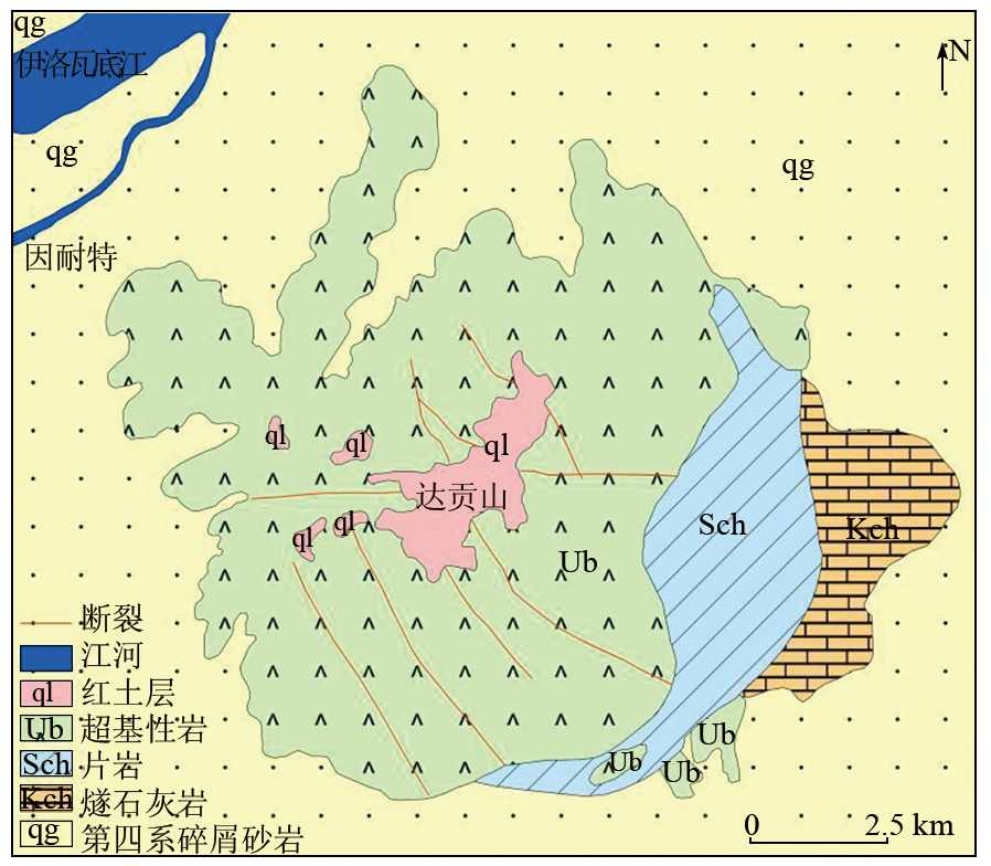
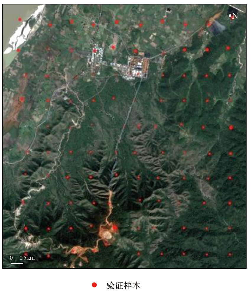
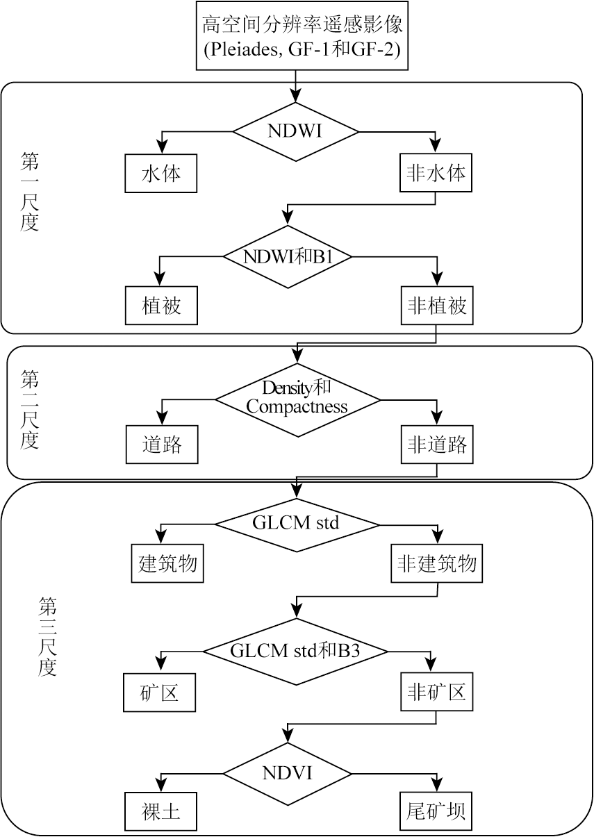
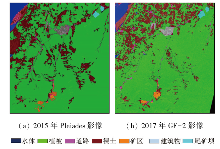
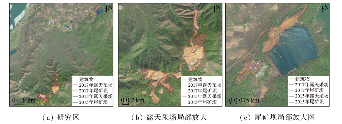
High-resolution remote sensing images have been widely applied to classification of ore deposits. However, there is a lack of studies on the information extraction and dynamic monitoring of open-pit lateritic nickel deposits. Using high-resolution remote sensing images from the Pleiades and GF-2 satellites, this study investigated the famous open-pit Tagaung Taung nickel deposit in Myanmar. First, information about surface features was extracted using object-oriented classification based on hierarchical multi-scale segmentation. Then, the dynamic changes in the nickel deposit were analyzed. Finally, qualitative and quantitative assessments of the classification accuracy were carried out. The results indicate that the hierarchical multi-scale segmentation technology exhibited encouraging classification and identification effects, with overall classification accuracy of 94.24% and 89.02% and the Kappa coefficients of 0.889 and 0.816, respectively for images from the Pleiades and GF-2 satellites. Therefore, the proposed method is suitable for the information extraction of open-pit lateritic nickel deposits. The dynamic change analysis reveals that the Tagaung Taung nickel deposit experienced continuous expansion of mining at high mining speeds from 2015 to 2017. It can be inferred that this deposit has great potential and broad prospects for resource development. The results of this study can provide technical support for the dynamic monitoring of the Tagaung Taung nickel deposit in Myanmar.
Upadhyay P, Ghosh S K, Kumar A, et al. Effect on specific crop mapping using WorldView-2 multispectral add-on bands:Soft classification approach[J]. Journal of Applied Remote Sensing, 2012, 6(1):063524.
[2]
Mutanga O, Adam E, Cho M A. High density biomass estimation for wetland vegetation using WorldView-2 imagery and random forest regression algorithm[J]. International Journal of Applied Earth Observation and Geoinformation, 2012, 18:399-406.
[3]
Pacifici F, Chini M, Emery W J. A neural network approach using multi-scale textural metrics from very high-resolution panchromatic imagery for urban land-use classification[J]. Remote Sensing of Environment, 2009, 113(6):1276-1292.
[4]
Longbotham N, Chaapel C, Bleiler L, et al. Very high resolution multiangle urban classification analysis[J]. IEEE Transactions on Geoscience and Remote Sensing, 2011, 50(4):1155-1170.
Gao J H, Zou L X, Long H, et al. Analysis on characteristics of mine geological environment and ecological restoration changes in Jilin Province based on dynamic remote sensing monitoring[J]. Remote Sensing for Natural Resources, 2022, 34(3):240-248.doi:10.6046/zrzyyg.2021278.
Wang J, Liu X Y, Yang J Z, et al. Typical model analysis of mine geological environment restoration and management in Zhejiang Province based on domestic high-resolution satellite data[J]. Remote Sensing for Land and Resources, 2020, 32(3):216-221.doi:10.6046/gtzyyg.2020.03.28.
Wang H Q, Hao J T, Li L, et al. Mining intensity analysis of each administrative region in Tibet based on remote sensing[J]. Remote Sensing for Land and Resources, 2020, 32(1):115-119.doi:10.6046/gtzyyg.2020.01.16.
Zhao Y L. Study and application of analytic hierarchy process of mine geological environment:A case study in Hainan Island[J]. Remote Sensing for Land and Resources, 2020, 32(1):148-153.doi:10.6046/gtzyyg.2020.01.20.
Xu Z H, Pan W, Zhang Y T. Application of GF1 image in lithology recognition of hydrothermal uranium metallogenic area,South China[J]. Uranium Geology, 2021, 37(2):227-234.
Fan Y L, Lou D B, Zhang C Q, et al. Information extraction technolo-gies of iron mine tailings based on object-oriented classification:A case study of Beijing-2 remote sensing images of the Qianxi Area,Hebei Province[J]. Remote Sensing for Natural Resources, 2021, 33(4):153-161.doi:10.6046/zrzyyg.2021027.
Cai X, Li Q, Luo Y, et al. Surface features extraction of mining area image based on object-oriented and deep-learning method[J]. Remote Sensing for Land and Resources, 2021, 33(1):63-71.doi:10.6046/gtzyyg.2020111.
Dong B S, Yang Y, Cui Q F. Detailed classification and analysis based on separator No.2 land use in mining area[J]. Journal of Gansu Sciences, 2019, 31(1):81-85.
Li X Q, Ni B, Peng X. Analysis and comparison of extracting manganese mineralization information from OLI and GF-2 data:An example of the malkansu manganese mine in West Kunlun,Xinjiang[J]. Geology and Exploration, 2020, 56(5):1040-1049.
Li H K, Weng X Y. Study on stratified and classified extraction method of ion-adsorption rare earth mining area surface cover based on GF-2 image[J]. Chinese Rare Earths, 2022, 43(2):108-119.
Huang H P, Wu B F. Analysis of the mutli-scale characteristics with objects extraction[J]. Remote Sensing Technology and Application, 2003, 18(5):276-281.
Dang T, Song Q, Liu Y, et al. Extraction of buildings in remote sensing imagery based on multi-level segmentation and classification hierarchical model and feature space optimization[J]. Remote Sensing for Land and Resources, 2019, 31(3):111-122.doi:10.6046/gtzyyg.2019.03.15.
Zhang D H, Sun Y. Geololgical-geochemistry characteristics and minerogenesis of nickel-bearing weathering crust in Taguang Taung,Myanmar[J]. Journal of Guilin University of Technology, 2010, 30(3):332-338.
Pan H, Zhou S Y, Li X B, et al. The geochemical anomaly characteristics and prospecting potential of the Na ta Lin Taung nickel-chromium polymetallic mineral in Taguang Taung,Myanmar[J]. World Nonferrous Metals, 2018(8):118-120.
Zuo L Y. Study on production exploration,development and utilization and deep prospecting in H district of Dagongshan nickel mine in Myanmar[J]. China Resources Comprehensive Utilization, 2020, 38(3):79-81.
Zhou S Y, Yang M D, Yan Z J, et al. Geological characteristics of Tagaung Taung Nichrome Mine in Mandalay,Myanmar[J]. Mineral Deposits, 2014, 33(s1):1149-1150.
Chen Z R, Liu S Z, Liu S J, et al. Classification of arid sand remote sensing image based on Pleiades-1 high resolution satellite image:A case study of Qingtu Lake in Minqin County of Gansu Province[J]. Chinese Agricultural Science Bulletin, 2015, 31(20):126-130.
Liu M X, Liu J H, Ma M F, et al. Monitoring of Zanthoxylum bungeanum Maxim planting using GF-2 PMS images and the random forest algorithm:A case study of Linxia,Gansu Province[J]. Remote Sensing for Natural Resources, 2022, 34(1):218-229.doi:10.6046/zrzyyg.2021112.
[24]
Chen L, Qin Q M, Chen C, et al. Remote sensing information of mineralizing alteration extraction methods[C]// 2012 IEEE International Geoscience and Remote Sensing Symposium.Munich,Germany.IEEE, 2012:5947-5950.
[25]
Chen L, Qin Q M, Bai Y B, et al. Integrating remote sensing and super-low frequency electromagnetic technology in exploration of buried faults[C]// 2013 IEEE International Geoscience and Remote Sensing Symposium - IGARSS.Melbourne,VIC,Australia.IEEE, 2013:811-814.
[26]
Zhen G W, Chen L, Chen C, et al. Alteration anomaly information extraction using hyperspectral remote sensing in coalbed methane enrichment[C]// 2016 IEEE International Geoscience and Remote Sensing Symposium (IGARSS).Beijing,China.IEEE, 2016:5394-5397.
Li J X, Wen J H. Analysis of high-resolution image information extraction method based on multi-scale segmentation technology[J]. Protection Forest Science and Technology, 2021(1):42-45.
Chen J R, Zhou X H, Lu X. Object-oriented classification method for surface features based on hierarchical and multi-scale segmentation[J]. Jiangxi Cehui, 2018(4):26-29.
Su T F. A unsupervised quality valuation method for multi-scale remote sensing image segmentation based on boundary information[J]. Remote Sensing for Natural Resources, 2023, 35(1):35-40.doi:10.6046/zrzyyg.2021444.
Liu X D, Yu N, Qiu H Y. Hierarchical muti-scale vegetation segmentation of remote sensing image based on spectrum histogram[J]. Remote Sensing for Land and Resources, 2017, 29(2):82-89.doi:10.6046/gtzyyg.2017.02.12.
Xue Y S. Multi-scale segmentation method regarding land cover change detection of national geographic conditions monitoring[J]. Geomatics & Spatial Information Technology, 2021, 44(1):47-51.
[32]
Chen L, Li W, Zhang X, et al. Application of object-oriented classification with hierarchical multi-scale segmentation for information extraction in nonoc nickel mine,the Philippines[C]// 2018 Fifth International Workshop on Earth Observation and Remote Sensing Applications (EORSA).Xi’an,China.IEEE, 2018:1-3.
 2024, Vol. 36
  ), 张仙, 李伟, 李瑜(