Monitoring 2018—2022 changes in lake levels across China using ICESat-2 data
JING Ruofan1,2,3(), LIAO Jingjuan1,2(), MA Shanmu1,2,3
1. Key Laboratory of Digital Earth Science,Aerospace Information Research Institute,Chinese Academy of Sciences,Beijing 100094,China 2. International Research Center of Big Data for Sustainable Development Goals,Beijing 100094,China 3. University of Chinese Academy of Sciences,Beijing 100049,China
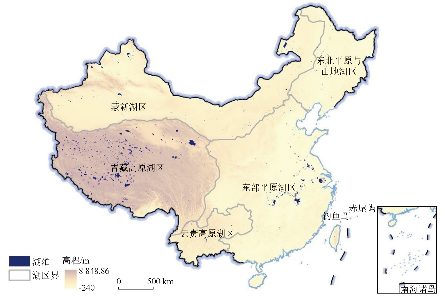
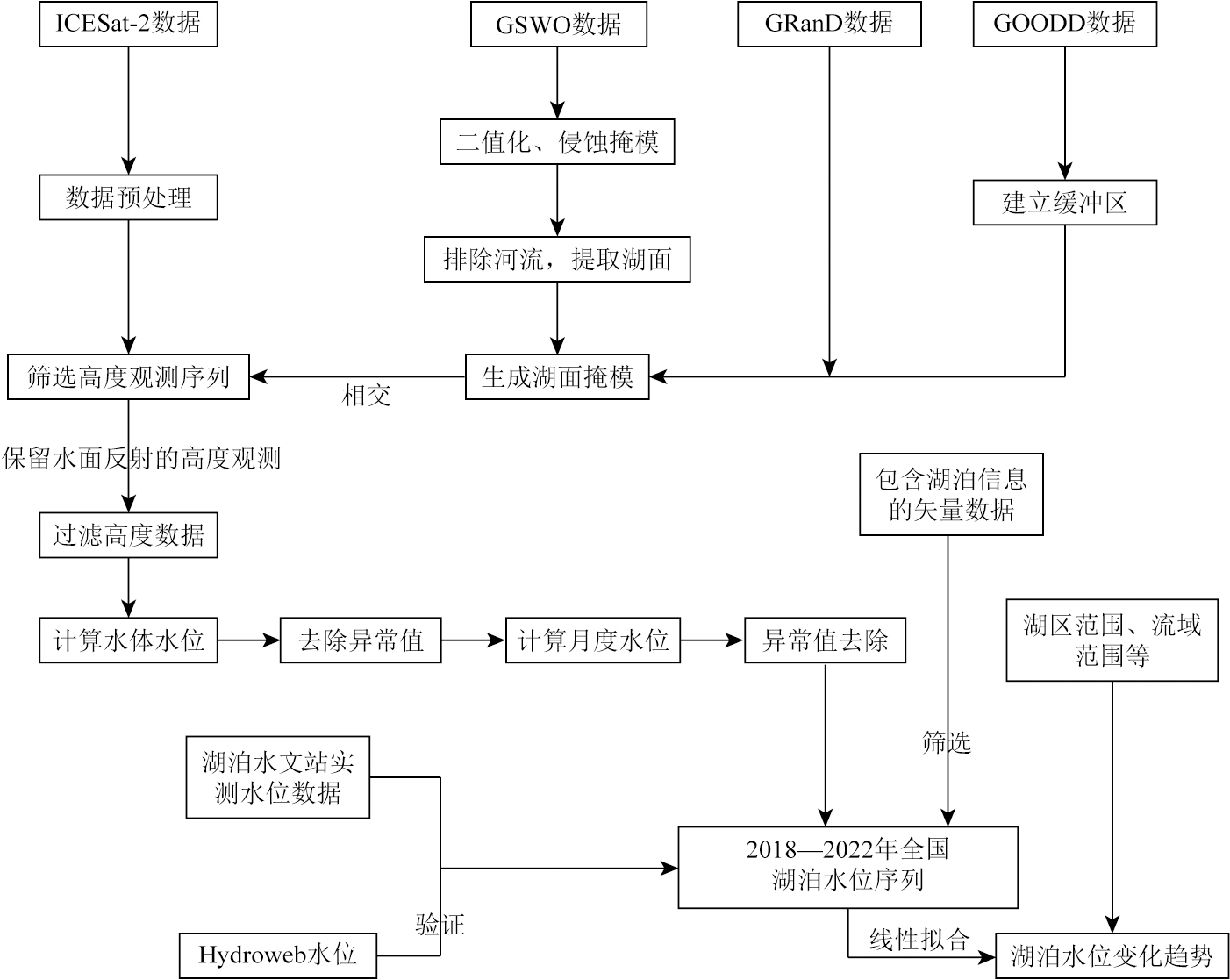
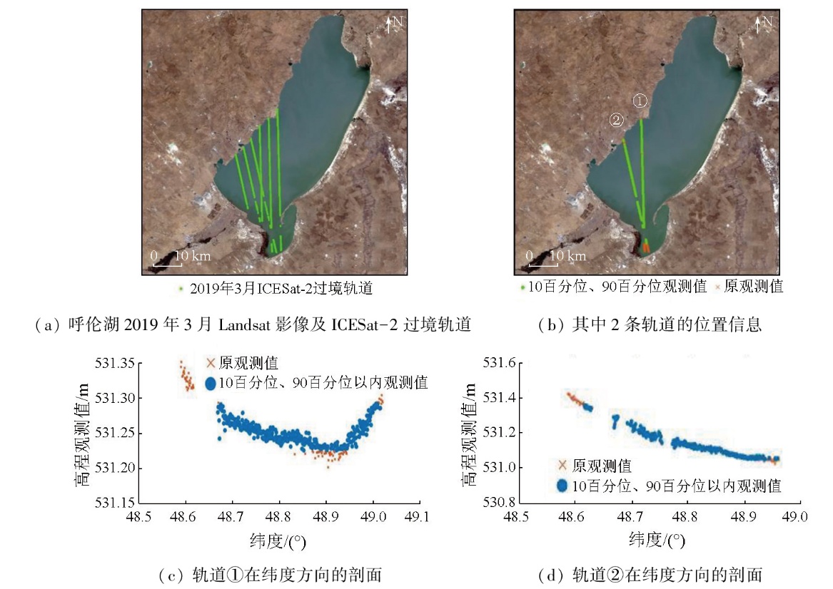
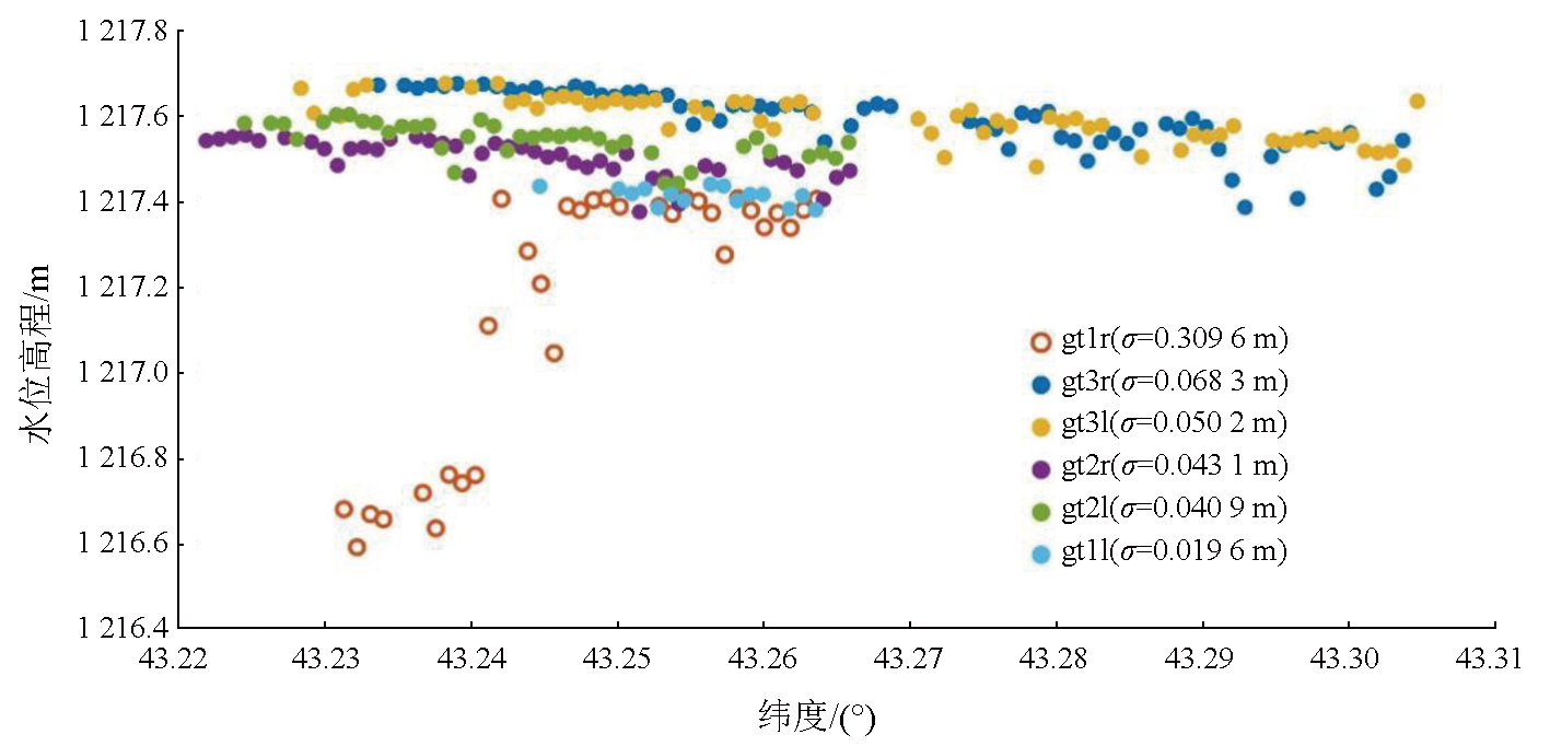
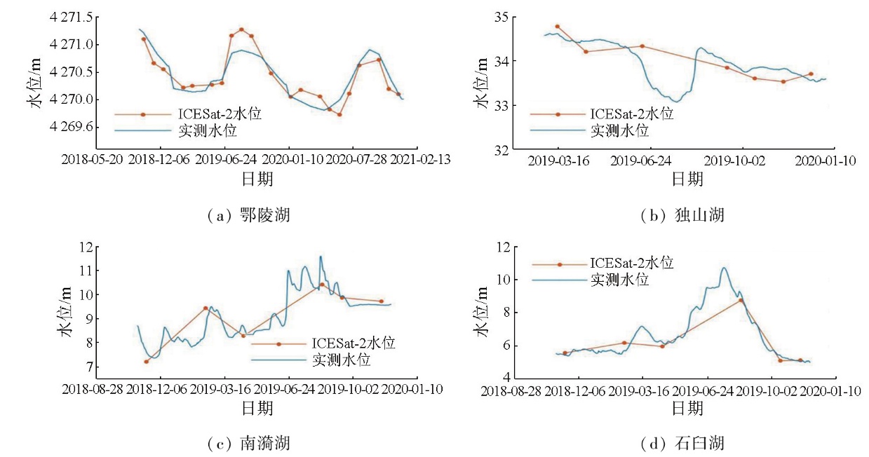
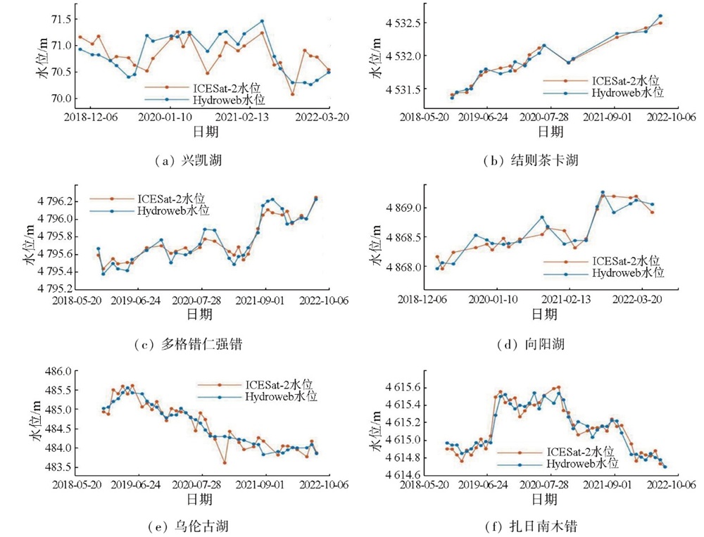
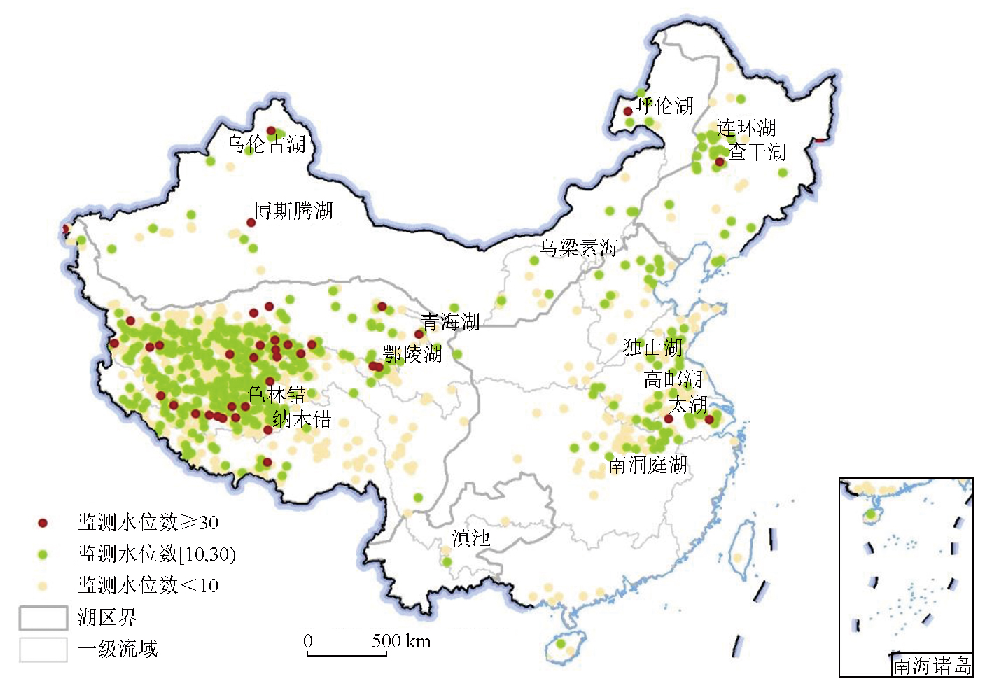
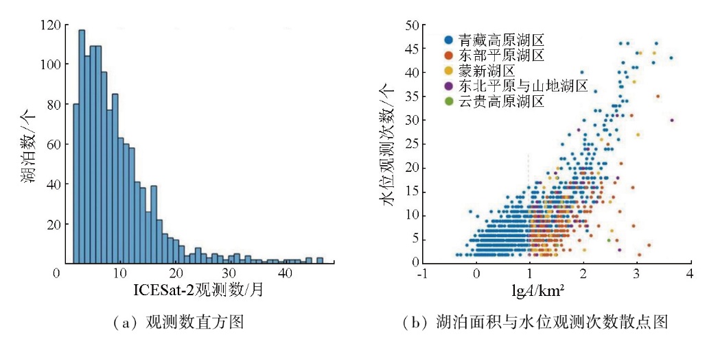
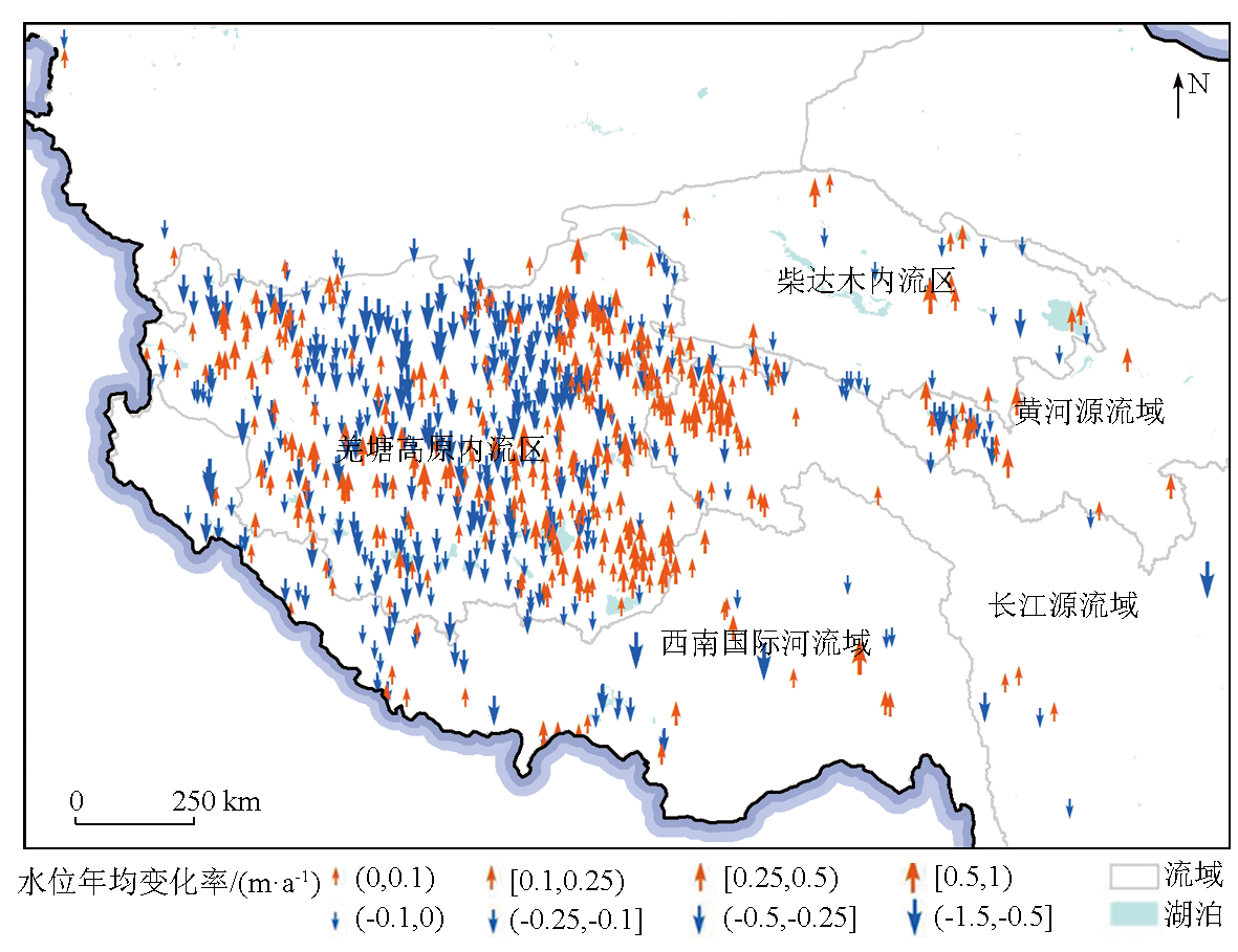
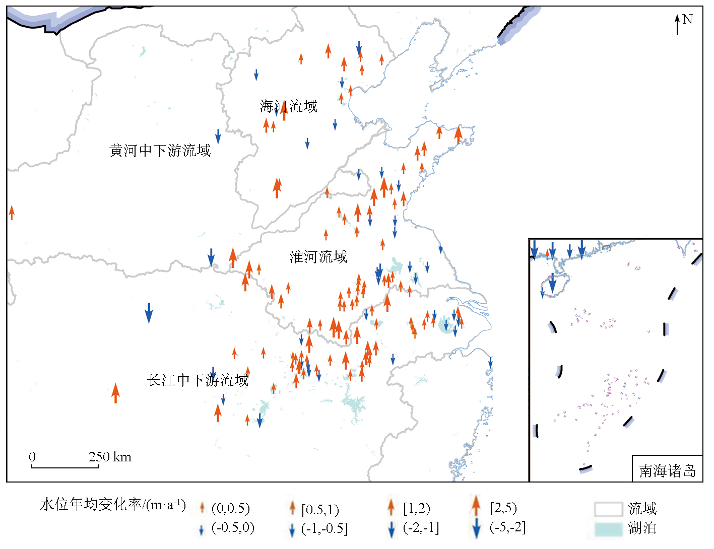
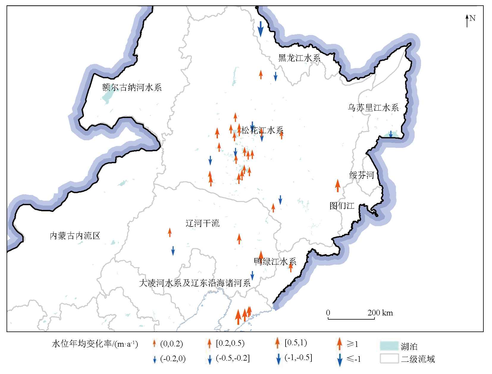
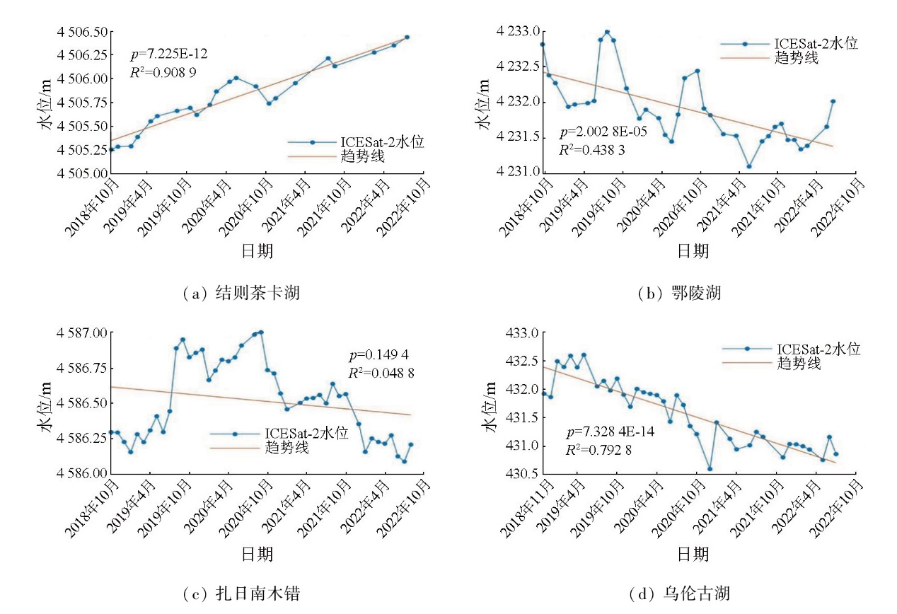
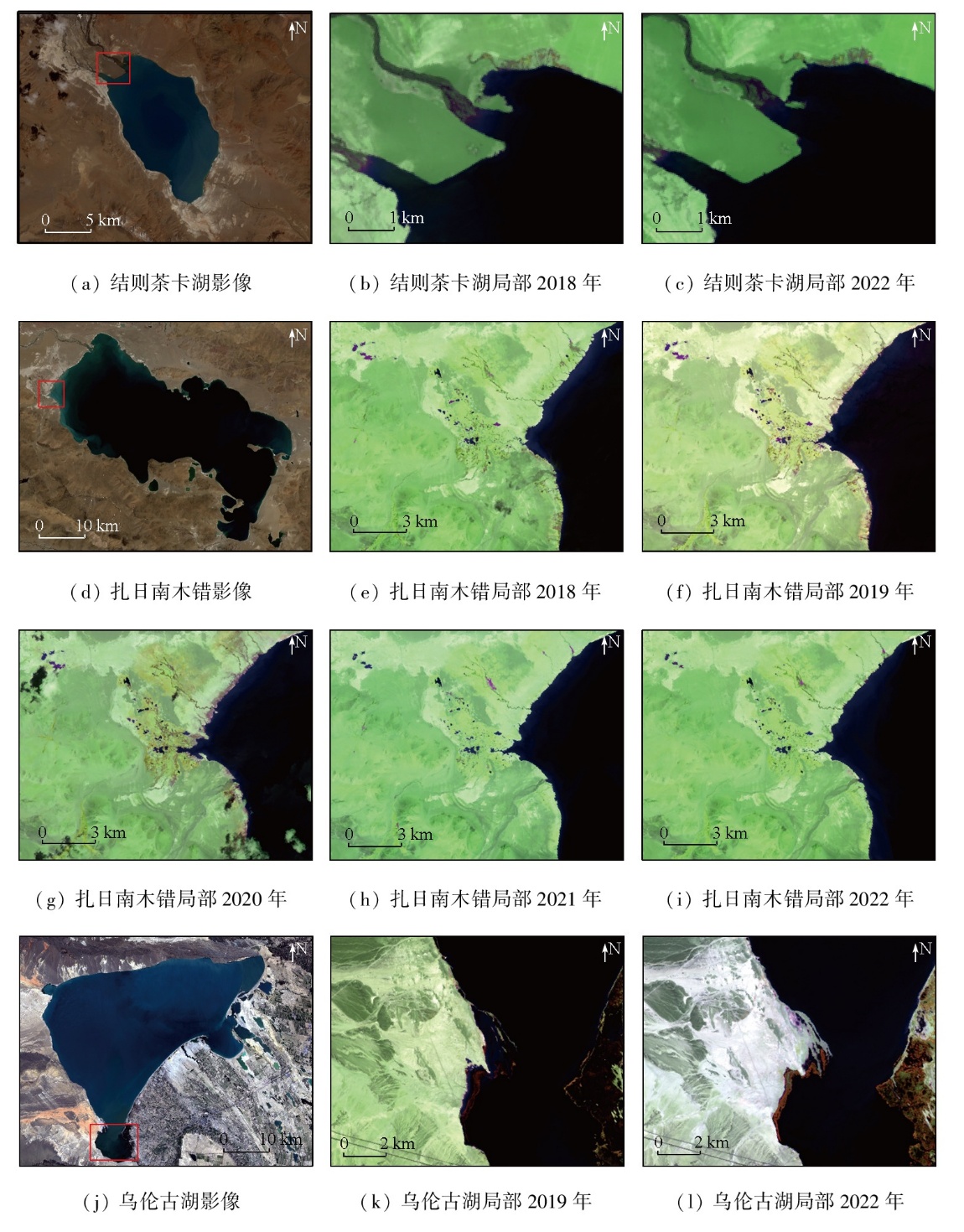
Satellite altimetry enables non-contact,large-scale Earth observation,providing technical support for monitoring changes in water levels of lakes where there is a lack of ground-based hydrological stations. The ICESat-2 laser altimeter features small footprints and high measurement accuracy,enjoying advantages in monitoring small-to medium-sized lakes. Therefore,this study extracted water level data from October 2018 to August 2022 for 1248 lakes across China based on ICESat-2 ATL08 data. The extracted data were validated using measured water level data from 18 lakes and Hydroweb data from 36 ones. Subsequently,based on the division of China's five major lake regions,this study analyzed variations in water levels of 957 lakes that were observed for over two years in at least four campaigns. The results show that the root mean square errors (RMSEs) between ICESat-2-derived and measured lake levels showed a minimum of 0.097 m. The cross-validation with Hydroweb data yielded a correlation coefficient of 0.95 and a minimum RMSE of 0.085 m. These results demonstrate the high precision and accuracy of the water level retrieval based on the ICESat-2 data. The lake levels on the Tibetan Plateau exhibited a slow rising trend,while those in northwestern China showed a declining trend. In eastern China,the water levels of large lakes displayed no significant variation trend,whereas those of small lakes showed pronounced fluctuations. Overall,the lake levels across China exhibited a gently rising trend. This study achieved high-precision measurement and monitoring of variations in lake levels across China,providing a scientific basis for water resource protection,ecological management,and the exploration of the responses of lake levels to human activities and climate change.
井若凡, 廖静娟, 马山木. ICESat-2数据监测全国湖泊2018—2022年水位变化[J]. 自然资源遥感, 2025, 37(5): 1-14.
JING Ruofan, LIAO Jingjuan, MA Shanmu. Monitoring 2018—2022 changes in lake levels across China using ICESat-2 data. Remote Sensing for Natural Resources, 2025, 37(5): 1-14.
Wu H B, Guo Z M, Mao R J. Monitoring lake water level changes in the middle and Lower Yangtze River Basin based on ICESat-GLAS altimetry data[J]. Resources Science, 2012, 34(12):2289-2298.
Gao L, Liao J J, Liu H L, et al. Applying status and development tendency of satellite Radar altimeter[J]. Remote Sensing Technology and Application, 2013, 28(6):978-983.
Zhao Y. Method of monitoring water level change of main lakes in China with Radar altimeter data[D]. Beijing: University of Chinese Academy of Sciences (Institute of Remote Sensing and Digital Earth Chinese Academy of Sciences), 2017.
[4]
Chen J, Liao J. Monitoring lake level changes in China using multi-altimeter data (2016-2019)[J]. Journal of Hydrology, 2020, 590:125544.
An D L, Yang J, Wu Y B, et al. Current research progress and applications of ICESat-2 laser altimetry satellite[J]. Hydrographic Surveying and Charting, 2019, 39(6):9-15.
[7]
Cooley S W, Ryan J C, Smith L C. Human alteration of global surface water storage variability[J]. Nature, 2021, 591(7848):78-81.
[8]
Luo S, Song C, Zhan P, et al. Refined estimation of lake water level and storage changes on the Tibetan Plateau from ICESat/ICESat-2[J]. CATENA, 2021, 200:105177.
Zhang G Q, Wang M M, Zhou T, et al. Progress in remote sensing monitoring of lake area,water level,and volume changes on the Tibetan Plateau[J]. National Remote Sensing Bulletin, 2022, 26(1):115-125.
Ma S M, Gan F P, Wu H C, et al. ICESat-2 data-based monitoring of 2018—2021 variations in the water levels of lakes in the Qinghai-Tibet Plateau[J]. Remote Sensing for Natural Resources, 2022, 34(3):164-172.doi:10.6046/zrzyyg.2021329.
[11]
Wang X, Gong P, Zhao Y, et al. Water-level changes in China’s large lakes determined from ICESat/GLAS data[J]. Remote Sensing of Environment, 2013, 132:131-144.
[12]
张国庆, Xie H J, 姚檀栋, 等. 基于ICESat和Landsat的中国十大湖泊水量平衡估算[J]. 科学通报, 2013, 58(26):2664-2678.
Zhang G Q, Xie H J, Yao T D, et al. Estimation of water balance of ten lakes in China based on ICESat and landsat[J]. Chinese Science Bulletin, 2013, 58(26):2664-2678.
[13]
王娜. 中国五大湖区湖泊生态系统结构及水生生物演化比较研究[D]. 南京: 南京大学, 2012.
Wang N. Comparative study on the structure of lake ecosystem and the evolution of aquatic organisms in the five great lakes of China[D]. Nanjing: Nanjing University, 2012.
[14]
Wan W, Long D, Hong Y, et al. A lake data set for the Tibetan Plateau from the 1960s,2005,and 2014[J]. Scientific Data, 2016, 3:160039.
Wu H B, Wang N L, Guo Z M. Application of ICESat-2/ATLAS altimetry data to the estimation of the Qinghai Lake water level[J]. Journal of Water Resources and Water Engineering, 2021, 32(5):11-18,26.
[16]
Tao S, Fang J, Zhao X, et al. Rapid loss of lakes on the Mongolian Plateau[J]. Proceedings of the National Academy of Sciences of the United States of America, 2015, 112(7):2281-2286.
doi: 10.1073/pnas.1411748112
pmid: 25646423
[17]
Zhang G, Yao T, Chen W, et al. Regional differences of lake evolution across China during 1960—2015 and its natural and anthropogenic causes[J]. Remote Sensing of Environment, 2019, 221:386-404.
 2025, Vol. 37
  ), 廖静娟1,2(