Please wait a minute...
 
自然资源遥感  2024, Vol. 36 Issue (1): 210-216    DOI: 10.6046/zrzyyg.2022478
  技术应用 本期目录 | 过刊浏览 | 高级检索 |
基于ICESat-2和Sentinel-2A数据的森林蓄积量反演
刘美艳1,2(), 聂胜2(), 王成2, 习晓环2, 程峰1, 冯宝坤1
1.云南师范大学地理学部,昆明 650500
2.中国科学院空天信息创新研究院数字地球重点实验室,北京 100094
Forest stock volume inversion based on ICESat-2 and Sentinel-2A data
LIU Meiyan1,2(), NIE Sheng2(), WANG Cheng2, XI Xiaohuan2, CHENG Feng1, FENG Baokun1
1. Faculty of Geography, Yunnan Normal University, Kunming 650500, China
2. Key Laboratory of Digital Earth Sciences, Aerospace Information Research Institute, Chinese Academy of Sciences, Beijing 100094, China
全文: PDF(6259 KB)   HTML  
输出: BibTeX | EndNote (RIS)      
摘要 

森林蓄积量是林业调查的重要指标,在衡量森林健康状况和评价森林固碳能力等方面发挥重要作用,协同主被动遥感是当前反演大区域森林蓄积量的主要手段。以云南香格里拉森林为研究区,分别提取ICESat-2/ATLAS和Sentinel-2A影像的特征变量,并通过相关性分析和共线性诊断方法筛选特征变量,构建Sentinel-2A变量集和ICESat-2/ATLAS变量集,以及二者联合的变量集,然后结合样地实测数据与3个特征变量集,采用逐步线性回归和随机森林方法分别建立线性和非线性回归模型,反演森林蓄积量,并对结果进行精度验证及对比分析。研究结果表明: 对3个变量集,随机森林方法精度均优于逐步线性回归; ICESat-2/ATLAS变量集在2种回归方法下的反演精度均高于Sentinel-2A变量集; 联合Sentinel-2A和ICESat-2/ATLAS变量集,随机森林方法的反演精度最高,其R2,RMSErRMSE分别为0.703 4,84.78 m3/hm2和36.46%。整体来说,与Sentinel-2A数据相比,基于ICESat-2/ATLAS数据及其与多源数据联合的反演模型均可以提高森林蓄积量反演精度和模型稳定性。

服务
把本文推荐给朋友
加入引用管理器
E-mail Alert
RSS
作者相关文章
刘美艳
聂胜
王成
习晓环
程峰
冯宝坤
关键词 森林蓄积量特征变量随机森林多元回归ICESat-2/ATLASSentinel-2A    
Abstract

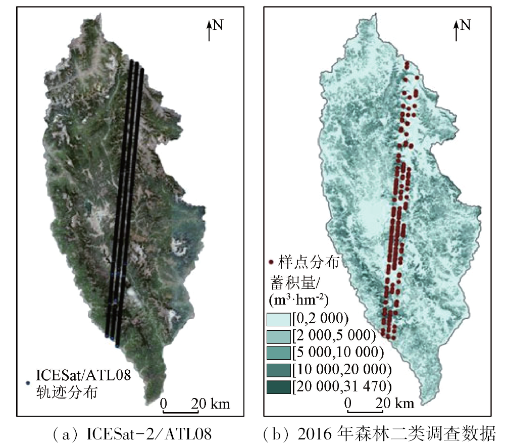
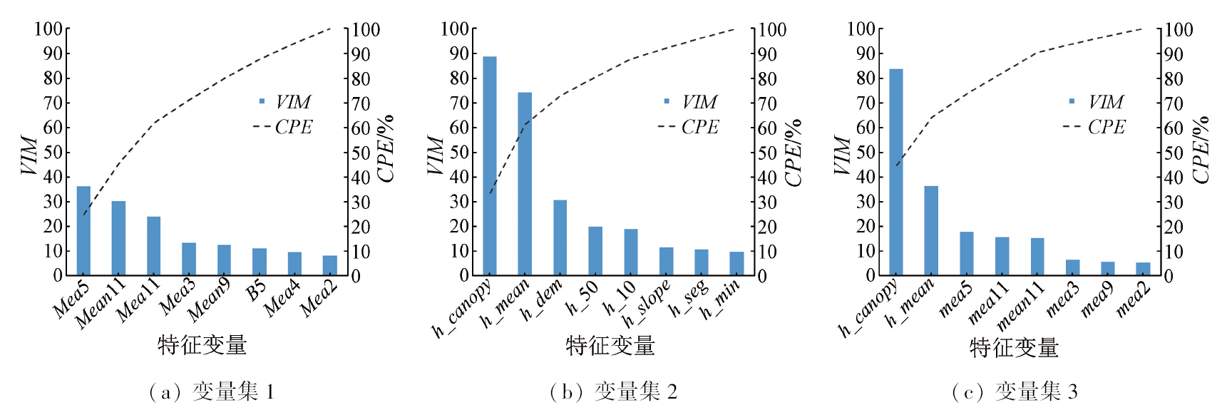
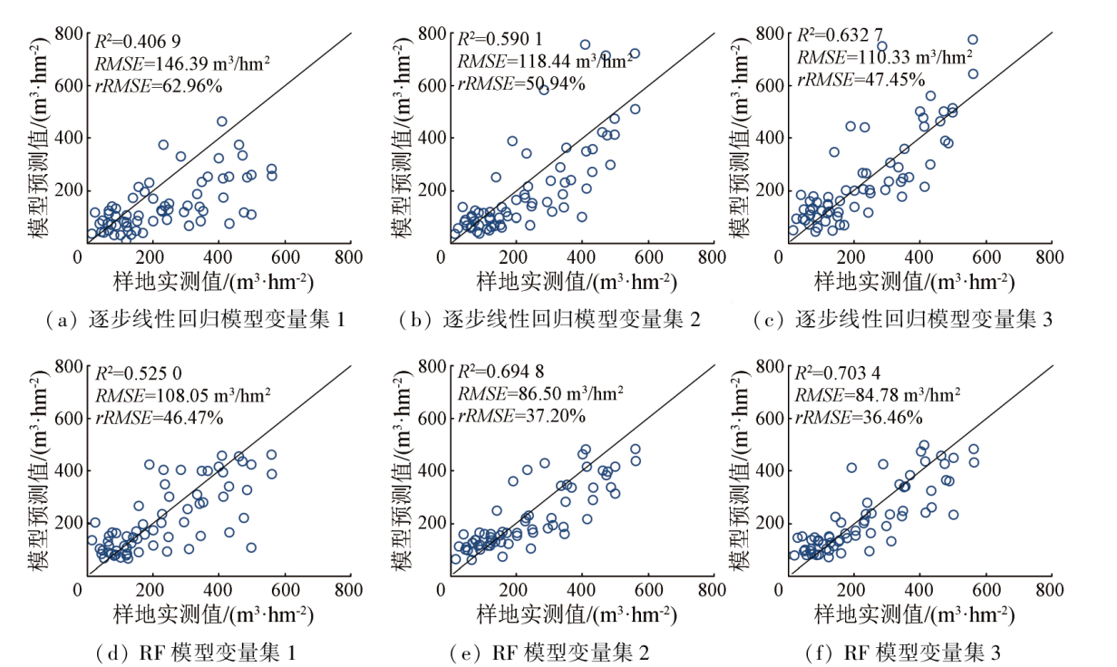
Forest stock volume (FSV), a critical indicator in forestry surveys, plays a significant role in evaluating the health and carbon sequestration capacity of forests. Cooperative inversion using active and passive remote sensing data is an essential method for FSV inversion of large areas. Focusing on forests in Shangri-La, Yunnan Province, this study extracted feature variables from ICESat-2/ATLAS and Sentinel-2A images and then screened them through correlation analysis and collinearity diagnostics. Using the selected feature variables, this study constructed a Sentinel-2A variable set, an ICESat-2/ATLAS variable set, and a combined variable set. Based on the measured data of sample sites and the three feature variable sets, this study built linear and nonlinear regression models for FSV inversion using stepwise linear regression and the random forest method, respectively. Finally, this study performed accuracy verification and comparative analysis of the results: ① For the three variable sets, the random forest method yielded higher accuracy than the stepwise linear regression; ② The ICESat-2/ATLAS variable set exhibited higher inversion accuracy than the Sentinel-2A variable set under both regression methods; ③ Combining Sentinel-2A and ICESat-2/ATLAS variable sets, the random forest method yielded the highest inversion accuracy, with its coefficient of determination (R2), root mean square error (RMSE), and relative root mean square error (rRMSE) of 0.7034, 84.78 m3/hm2, and 36.46%, respectively. Overall, compared to Sentinel-2A data, the inversion models based on ICESat-2/ATLAS data and multi-source remote sensing data can effectively improve the accuracy of FSV inversion and model stability.

Key wordsforest stock volume    feature variable    random forest    multiple regression    ICESat-2/ATLAS    Sentinel-2A
收稿日期: 2022-12-05      出版日期: 2024-03-13
ZTFLH:  S758.57  
  TP79  
基金资助:广西自然科学基金创新研究团队项目“广西森林垂直结构LiDAR反演及生物量监测”(2019GXNSFGA245001);湖湘高层次人才聚集工程—创新团队项目(2019RS1060);中国科学院青年创新促进会项目(2019130)
通讯作者: 聂 胜(1990-),男,博士,副研究员,主要从事激光雷达及全球变化应用研究。Email: niesheng@aircas.ac.cn
作者简介: 刘美艳(1998-),女,硕士研究生,主要从事林业遥感研究。Email: meiyanliu@user.ynnu.edu.cn
引用本文:   
刘美艳, 聂胜, 王成, 习晓环, 程峰, 冯宝坤. 基于ICESat-2和Sentinel-2A数据的森林蓄积量反演[J]. 自然资源遥感, 2024, 36(1): 210-216.
LIU Meiyan, NIE Sheng, WANG Cheng, XI Xiaohuan, CHENG Feng, FENG Baokun. Forest stock volume inversion based on ICESat-2 and Sentinel-2A data. Remote Sensing for Natural Resources, 2024, 36(1): 210-216.
链接本文:  
https://www.gtzyyg.com/CN/10.6046/zrzyyg.2022478      或      https://www.gtzyyg.com/CN/Y2024/V36/I1/210
Fig.1  研究区卫星数据和蓄积量分布
蓄积量/
(m3·hm-2)
样地
数/个
最大值/
(m3·hm-2)
最小值/
(m3·hm-2)
均值/
(m3·hm-2)
[0,200) 134 193 3 96
[200,400) 43 369 201 286
≥400 28 666 400 475
Tab.1  森林蓄积量统计信息
名称 描述 参数符号
h_canopy 估计地形表面以上路段所有单独树冠相对高度的98%。通过将冠层光子高度与估计的地形表面进行差分,计算出相对冠层高度 h_canopy
h_mean_
canopy
单个相对冠层高度的平均值 h_mean
h_max_
canopy
单个冠层高度最大值 h _ max
h_min_
canopy
单个冠层高度最小值 h _ min
n_seg_ph 每个陆地段内光子数 h_seg
dem_h 地理定位点最佳可用数字高程模型,m h_dem
terrain_
slope
地形的沿轨道坡度 h_slope
h_te_best_fit 每100 m路段中点位置的最佳地形高程,m h_ terrain
canopy_h_metrics 基于内插地面上方相对树冠高度累积分布的高度度量,高度指标按以下百分位数计算: 10%,15%,20%,25%,30%,35%,40%,45%,50%,55%,60%,65%,70%,75%,80%,85%,90%,95%,共有18个 h_m (m=10,15,…,95)
Tab.2  ICESat-2/ATL08数据产品参数
名称 公式 名称 公式
归一化植被指数NDVI N D V I = N I R - R N I R + R 增强型植被指数EVI E V I = 2.5 ( N I R - R ) N I R + 6 R - 7 B + 1
比值植被指数RVI R V I = N I R R 可见光抗大气指数VARI V A R I = G - R G + R + B
差值植被指数DVI D V I = N I R - R 大气抗阻植被指数ARVI A R V I = N I R - 2 ( R - B ) N I R + 2 ( R - B )
红绿植被指数RGVI R G V I = R - G R + G 土壤修正植被指数SAVI S A V I = ( 1 + L ) ( N I R - R ) ( N I R - R + L )
L=0.1,0.25,0.5
Tab.3  植被指数
名称 描述 参数符号
数据范围 灰度值的范围 Rani
均值 灰度值的平均值 Meai
方差 灰度值的变化程度 Vari
信息熵 纹理的复杂程度 Enti
偏斜 灰度值的变化频率 Skei
二阶均值 灰度值的平均值 Meani
二阶方差 灰度值的变化程度 Variance i
同质性 图像纹理的协同性 Homi
对比度 图像清晰度和纹理的沟纹深浅 Coni
异质性 相邻像元之间灰度值的差异大小 Disi
二阶信息熵 图像纹理的复杂程度和非均匀程度 Entropy i
二阶矩 图像灰度分布的均匀程度和纹理粗细程度 Seci
相关性 GLCM像元的相似程度 Cori
Tab.4  纹理特征参数
变量集 逐步线性回归公式 R2
1 Y1=2.279-0.015Mean9+0.007RVI-
0.002 Hom11-0.023Con2-0.003Hom3-
0.004Sec2
0.406 9
2 Y2=0.111 702h_canopy +0.000 387h_dem-
2.978
0.590 1
3 Y3=0.092h_canopy -0.01Mean9+
0.042Variance11+0.005DVI-1.097
0.632 7
Tab.5  逐步线性回归模型
Fig.2  重要性评分
模型 变量集 R2 RMSE/
(m3·hm-2)
rRMSE/
%
Bias/
(m3·hm-2)
逐步线性回归 变量集1 0.406 9 146.39 62.96 -87.220
变量集2 0.590 1 118.44 50.94 -27.894
变量集3 0.632 7 110.33 47.45 20.923
RF 变量集1 0.525 0 108.05 46.47 -19.486
变量集2 0.694 8 86.50 37.20 -17.627
变量集3 0.703 4 84.78 36.46 -16.559
Tab.6  精度对比
Fig.3  线性逐步回归和RF模型预测拟合图
[1] 陈新云, 李利伟, 刘承芳, 等. 热带原始森林类型分类和蓄积量遥感反演研究[J]. 林业资源管理, 2019(2):39-46.
Chen X Y, Li L W, Liu C F, et al. Remote sensing inversion of classification and stocking volume of tropical virgin forest types based on multivariate data[J]. Forest Resources Management, 2019(2):39-46.
[2] 龙依, 蒋馥根, 孙华, 等. 基于HLS数据的森林蓄积量遥感反演[J]. 森林与环境学报, 2021, 41(6):620-628.
Long Y, Jiang F G, Sun H, et al. Remote sensing inversion of forest volume based on HLS data[J]. Journal of Forest and Environment, 2021, 41(6):620-628.
[3] 李旺, 牛铮, 王成, 等. 机载LiDAR数据估算样地和单木尺度森林地上生物量[J]. 遥感学报, 2015, 19(4):669-679.
Li W, Niu Z, Wang C, et al. Forest above-ground biomass estimation at plot and tree levels using airborne LiDAR data[J]. Journal of Remote Sensing, 2015, 19(4):669-679.
[4] 陈松, 孙华, 吴童, 等. 基于Sentinel-2与机载激光雷达数据的误差变量联立方程组森林蓄积量反演研究[J]. 中南林业科技大学学报, 2020, 40(12):44-53.
Chen S, Sun H, Wu T, et al. Study on the forest volume inversion based on the simultaneous equations of error variables of Sentinel-2 and airborne LiDAR data[J]. Journal of Central South University of Forestry and Technology, 2020, 40(12):44-53.
[5] Wang W J, He H S, Thompson F R, et al. Changes in forest biomass and tree species distribution under climate change in the northeastern United States[J]. Landscape Ecology, 2017, 32(7):1399-1413.
doi: 10.1007/s10980-016-0429-z
[6] 刘雪莲, 欧绍龙, 陆双飞, 等. 基于Sentinel-1A微波遥感数据的森林蓄积量估测[J]. 西部林业科学, 2020, 49(6):128-136.
Liu X L, Ou S L, Lu S F, et al. Estimation of forest volume based on Sentinel-1A microwave remote sensing data[J]. Journal of West China Forestry Science, 2020, 49(6):128-136.
[7] 孙忠秋, 高金萍, 吴发云, 等. 基于机载激光雷达点云和随机森林算法的森林蓄积量估测[J]. 林业科学, 2021, 57(8):68-81.
Sun Z Q, Gao J P, Wu F Y, et al. Estimating forest stock volume via small-footprint LiDAR point cloud data and random forest algorithm[J]. Scientia Silvae Sinicae, 2021, 57(8):68-81.
[8] 宋涵玥, 舒清态, 席磊, 等. 基于星载ICESat-2/ATLAS数据的森林地上生物量估测[J]. 农业工程学报, 2022, 38(10):191-199.
Song H Y, Shu Q T, Xi L, et al. Remote sensing estimation of forest above-ground biomass based on spaceborne LiDAR ICESat-2/ATLAS data[J]. Transactions of the Chinese Society of Agricultural Engineering, 2022, 38(10):191-199.
[9] Duncanson L, Neuenschwander A, Hancock S, et al. Biomass estimation from simulated GEDI,ICESat-2 and NISAR across environmental gradients in Sonoma County,California[J]. Remote Sensing of Environment, 2020, 242:11779.
[10] 刘蓉姣, 张加龙, 陈培高. 基于混合像元分解的香格里拉市高山松空间分布变化研究[J]. 西北林学院学报, 2021, 36(1):9-17.
Liu R J, Zhang J L, Chen P G. Spatial distribution changes of the pinus densata forests in Shangri-La City based on mixed pixel decomposition[J]. Journal of Northwest Forestry University, 2021, 36(1):9-17.
[11] Magruder L A, Brunt K M, Alonzo M. Early ICESat-2 on-orbit geolocation validation using ground-based corner cube retro-reflectors[J]. Remote Sensing, 2020, 12(21):3653.
doi: 10.3390/rs12213653
[12] 朱笑笑, 王成, 习晓环, 等. ICESat-2星载光子计数激光雷达数据处理与应用研究进展[J]. 红外与激光工程, 2020, 49(11):20200259.
Zhu X X, Wang C, Xi X H, et al. Research progress of ICESat-2/ATLAS data processing and applications[J]. Infrared and Laser Engineering, 2020, 49(11):20200259.
doi: 10.3788/IRLA
[13] 徐晓雨, 孙华, 王广兴, 等. 基于GF-1与Landsat-8的康保县叶面积指数遥感反演研究[J]. 中南林业科技大学学报, 2018, 38(1):43-48.
Xu X Y, Sun H, Wang G X, et al. Modeling LAI of Kangbao County using GF-1 and Landsat8 image[J]. Journal of Central South University of Forestry and Technology, 2018, 38(1):43-48.
[14] 王宗梅, 徐天蜀, 岳彩荣, 等. 基于哑变量的高山松蓄积量反演模型研究[J]. 林业资源管理, 2017(4):75-81.
Wang Z M, Xu T S, Yue C R, et al. Application of dummy variable in the research of pinus densata stock volume inversion model[J]. Forest Resources Management, 2017(4):75-81.
[15] 董佳臣, 倪文俭, 张志玉, 等. ICESat-2植被冠层高度和地表高程数据产品用于森林高度提取的效果评价[J]. 遥感学报, 2021, 25(6):1294-1307.
Dong J C, Ni W J, Zhang Z Y, et al. Performance of ICESat-2 ATL08 product on the estimation of forest height by referencing to small footprint LiDAR data[J]. National Remote Sensing Bulletin, 2021, 25(6):1294-1307.
doi: 10.11834/jrs.20219449
[16] 韦丽清. 短波红外高灵敏度成像关键技术与应用研究[D]. 上海: 中国科学院大学(中国科学院上海技术物理研究所), 2017.
Wei L Q. Research of key technologies and application for high sensitivity short wave infrared imaging[D]. Shanghai: University of Chinese Academy of Sciences (Shanghai Institute of Technical Physics,Chinese Academy of Sciences), 2017.
[17] Immitzer M, Stepper C, Böck S, et al. Use of Worldview-2 stereo imagery and national forest inventory data for wall-to-wall mapping of growing stock[J]. Forest Ecology and Management, 2016, 359:232-246.
doi: 10.1016/j.foreco.2015.10.018
[18] 周振超. 基于多源遥感数据的红树林遥感信息识别研究——以湛江自然保护区为例[D]. 长春: 吉林大学, 2019.
Zhou Z C. Research on the identification of mangrove forest based on multi-source remote sensing data[D]. Changchun: Jilin University, 2019.
[19] 郎晓雪, 许彦红, 舒清态, 等. 香格里拉市云冷杉林蓄积量遥感估测非参数模型研究[J]. 西南林业大学学报(自然科学), 2019, 39(1):146-151.
Lang X X, Xu Y H, Shu Q T, et al. Nonparametric model for remote sensing estimating the volume of sprucefir forest in Shangri-La[J]. Journal of Southwest Forestry University(Natural Sciences), 2019, 39(1):146-151.
[20] 杨沁雨, 王瑞, 胥辉. 基于森林资源二类调查数据的香格里拉市森林生物量二阶抽样优化[J]. 西南林业大学学报(自然科学), 2021, 41(6):160-167.
Yang Q Y, Wang R, Xu H. Optimal design of second-order sampling for forest biomass in Shangri-La City based on the forest management inventory[J]. Journal of Southwest Forestry University(Natural Sciences), 2021, 41(6):160-167.
[21] 侯群群, 王飞, 严丽. 基于灰度共生矩阵的彩色遥感图像纹理特征提取[J]. 国土资源遥感, 2013, 25(4):26-32.doi:10.6046/gtzyyg.2013.04.05.
Hou Q Q, Wang F, Yan L. Extraction of color image texture feature based on gray-level co-occurrence matrix[J]. Remote Sensing for Land and Resources, 2013, 25(4):26-32.doi:10.6046/gtzyyg.2013.04.05.
[22] 杨福芹, 李天驰, 冯海宽, 等. 基于无人机数码影像的冬小麦氮素营养诊断研究[J]. 福建农业学报, 2021, 36(3):369-378.
Yang F Q, Li T C, Feng H K, et al. UAV digital image-assisted monitoring on nitrogen nutrition of winter wheat in the field[J]. Fujian Journal of Agricultural Sciences, 2021, 36(3):369-378.
[23] 冷建飞, 高旭, 朱嘉平. 多元线性回归统计预测模型的应用[J]. 统计与决策, 2016(7):82-85.
Leng J F, Gao X, Zhu J P. Application of multivariate linear regression statistical prediction model[J]. Statistics and Decision, 2016(7):82-85.
[24] Breiman L. Random forests[J]. Machine Learning, 2001, 45(1):5-32.
doi: 10.1023/A:1010933404324
[25] 邢晓语, 杨秀春, 徐斌, 等. 基于随机森林算法的草原地上生物量遥感估算方法研究[J]. 地球信息科学学报, 2021, 23(7):1312-1324.
doi: 10.12082/dqxxkx.2021.200605
[26] Sarker L R, Nichol J E. Improved forest biomass estimates using ALOS AVNIR-2 texture indices[J]. Remote Sensing of Environment, 2011, 115(4):968-977.
doi: 10.1016/j.rse.2010.11.010
[25] Xing X Y, Yang X C, Xu B, et al. Remote sensing estimation of grassland aboveground biomass based on random forest[J]. Journal of Geo-Information Science, 2021, 23(7):1312-1324.
[1] 卢献健, 张焕铃, 晏红波, 黎振宝, 郭子扬. 协同Sentinel-1/2多特征优选的甘蔗提取方法[J]. 自然资源遥感, 2024, 36(1): 86-94.
[2] 陈健, 李虎, 刘玉锋, 常竹, 韩伟杰, 刘赛赛. 基于Sentinel-2数据多特征优选的农作物遥感识别研究[J]. 自然资源遥感, 2023, 35(4): 292-300.
[3] 杜晓川, 娄德波, 徐林刚, 范莹琳, 张琳, 李婉悦. 基于GF-2影像和随机森林算法的花岗伟晶岩提取[J]. 自然资源遥感, 2023, 35(4): 53-60.
[4] 余绍淮, 徐乔, 余飞. 联合光学和SAR遥感影像的山区公路滑坡易发性评价方法[J]. 自然资源遥感, 2023, 35(4): 81-89.
[5] 钟骁勇, 李洪义, 郭冬艳, 谢模典, 赵婉如, 胡碧峰. 基于多源环境变量和随机森林模型的江西省耕地土壤pH值空间预测[J]. 自然资源遥感, 2023, 35(4): 178-185.
[6] 何苏玲, 贺增红, 潘继亚, 王金亮. 基于多模型的县域土地利用/土地覆盖模拟[J]. 自然资源遥感, 2023, 35(4): 201-213.
[7] 伍炜超, 叶发旺. 面向多背景环境的Sentinel-2云检测[J]. 自然资源遥感, 2023, 35(3): 124-133.
[8] 席磊, 舒清态, 孙杨, 黄金君, 宋涵玥. 基于ICESat2的西南山地森林LAI遥感估测模型优化[J]. 自然资源遥感, 2023, 35(3): 160-169.
[9] 排日海·合力力, 昝梅. 干旱区绿洲城市生态环境时空格局变化及影响因子研究[J]. 自然资源遥感, 2023, 35(3): 201-211.
[10] 梁锦涛, 陈超, 张自力, 刘志松. 一种融合指数与主成分分量的随机森林遥感图像分类方法[J]. 自然资源遥感, 2023, 35(3): 35-42.
[11] 吴玉鑫, 王卷乐, 韩保民, 严欣荣. 基于时空谱特征的墨脱县森林分类方法与实现[J]. 自然资源遥感, 2023, 35(1): 180-188.
[12] 张昊, 高小红, 史飞飞, 李润祥. 基于Sentinel-2 MSI与Sentinel-1 SAR相结合的黄土高原西部撂荒地提取——以青海民和县为例[J]. 自然资源遥感, 2022, 34(4): 144-154.
[13] 王春霞, 张俊, 李屹旭, Phoumilay. 复杂环境下GF-2影像水体指数的构建及验证[J]. 自然资源遥感, 2022, 34(3): 50-58.
[14] 邓静雯, 田义超, 张强, 陶进, 张亚丽, 黄升光. 机载LiDAR在红树林林分平均高估算中的应用[J]. 自然资源遥感, 2022, 34(3): 129-137.
[15] 王雪洁, 施国萍, 周子钦, 甄洋. 基于随机森林算法对ERA5太阳辐射产品的订正[J]. 自然资源遥感, 2022, 34(2): 105-111.
Viewed
Full text


Abstract

Cited

  Shared   
  Discussed   
京ICP备05055290号-2
版权所有 © 2015 《自然资源遥感》编辑部
地址:北京学院路31号中国国土资源航空物探遥感中心 邮编:100083
电话:010-62060291/62060292 E-mail:zrzyyg@163.com
本系统由北京玛格泰克科技发展有限公司设计开发