Multivariate alteration detection using angle thresholds based on a context-sensitive Bayesian network
ZHU Rui1(), LI Yikun1,2,3(), LI Xiaojun1,2,3, YANG Shuwen1,2,3, XIE Jiangling1
1. Faculty of Geomatics,Lanzhou Jiaotong University,Lanzhou 730070,China 2. National-Local Joint Engineering Research Center of Technologies and Applications for National Geographic State Monitoring,Lanzhou 730070,China 3. Key Laboratory of Science and Technology in Surveying & Mapping,Gansu Province,Lanzhou 730070,China
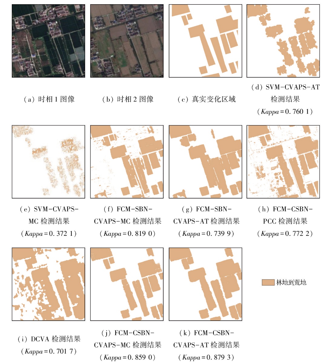
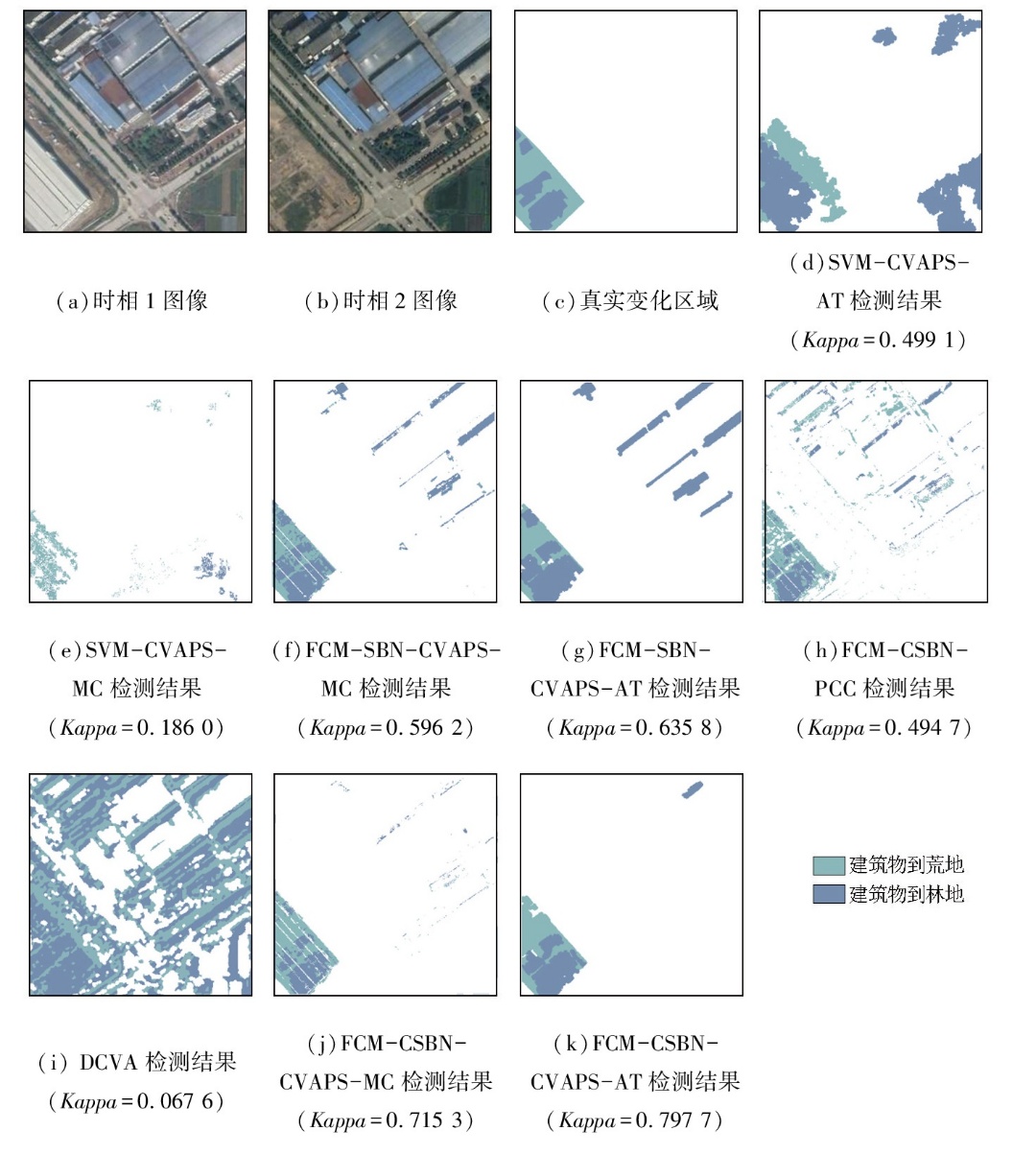
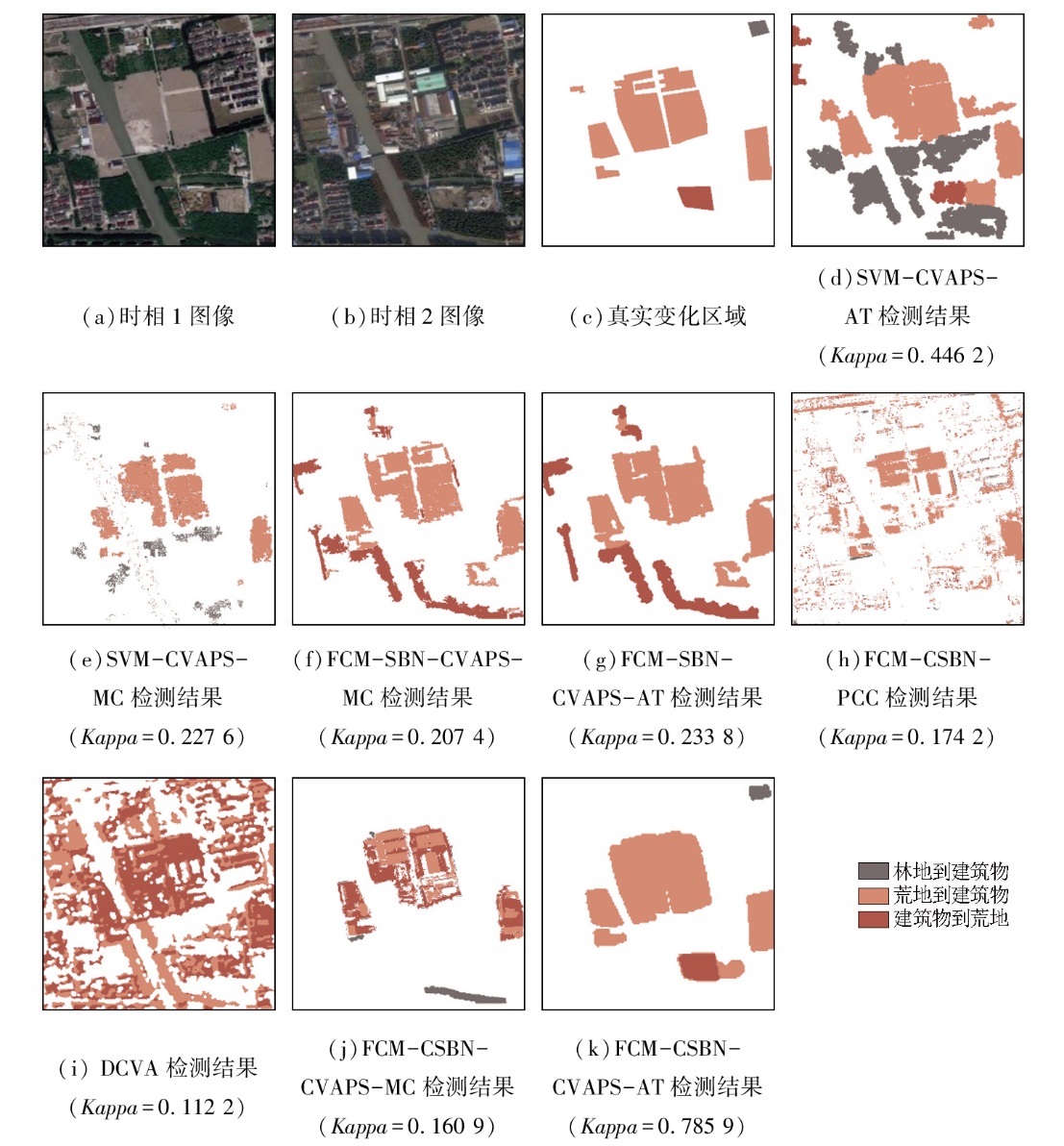
在遥感图像多变化检测领域中,后验概率空间变化向量分析(change vector analysis in posterior probability space,CVAPS)是一种得到广泛使用的变化检测方法。然而,CVAPS利用支持向量机来估计遥感图像像素的后验概率向量,易受到遥感图像中同物异谱、异物同谱、混合像元等因素的影响,从而难以准确估计复杂像元的后验概率向量的强度和方向,并影响了其后多元变化检测的精度。因此,文章在CVAPS的框架下,提出了一种采用模糊C均值聚类分解混合像元,并耦合上下文敏感的贝叶斯网络,使用角度阈值进行多变化类型检测的方法。当夹角小于一定阈值时,则判定该像素为该标准变化向量所代表的变化类型。实验结果证明该算法具有较高变化检测性能,取得了高于对比算法的精度。
In the field of multivariate alteration detection (MAD) of remote sensing images,change vector analysis in posterior probability space (CVAPS) is a widely used method. However,the CVAPS,which employs support vector machines to estimate the posterior probability vectors of remote sensing image pixels,is susceptible to various factors such as different objects with the same spectrum,the same object with different spectra,and mixed pixels in remote sensing images. These factors make it difficult to accurately estimate the magnitude and direction of the posterior probability vectors of complex pixels,consequently affecting the accuracy of multivariate alteration detection. Therefore,under the framework of CVAPS,this paper proposed a MAD method using angle thresholds,which employed the fuzzy C-means clustering to decompose mixed pixels and coupled a context-sensitive Bayesian network. When the angle is less than a certain threshold,the pixel is identified as the change type represented by the standard change vector. Experimental results show that the proposed algorithm exhibited superior alteration detection performance,achieving higher change detection accuracy than other algorithms.
朱睿, 李轶鲲, 李小军, 杨树文, 谢江陵. 基于上下文敏感贝叶斯网络的角度阈值多元变化检测[J]. 自然资源遥感, 2025, 37(5): 131-140.
ZHU Rui, LI Yikun, LI Xiaojun, YANG Shuwen, XIE Jiangling. Multivariate alteration detection using angle thresholds based on a context-sensitive Bayesian network. Remote Sensing for Natural Resources, 2025, 37(5): 131-140.
Li T H, Han P. Land use/cover change detection and analysis with remote sensing in Xiamen City[J]. Scientia Geographica Sinica, 2001, 21(6):537-543.
doi: 10.13249/j.cnki.sgs.2001.06.537
Yan Y, Liu Y L. Unsupervised remote sensing image change detection based on fusion and IFLICM algorithm[J]. Bulletin of Surveying and Mapping, 2018(3):25-31.
doi: 10.13474/j.cnki.11-2246.2018.0070
Song J X, Li Y K, Yang S W, et al. NSCT-based change detection for high-resolution remote sensing images under the framework of change vector analysis in posterior probability space[J]. Remote Sensing for Natural Resources, 2024, 36(3):128-136.doi:10.6046/zrzyyg.2023079.
Xie J L, Li Y K, Li X J, et al. Change detection using coupling spatial fuzzy C-means clustering and earth mover’s distance[J]. Remote Sensing Information, 2024, 39(3):144-152.
[6]
Song J X, Li Y K, Li X J, et al. Unsupervised remote sensing image classification with differentiable feature clustering by coupled transformer[J]. Journal of Applied Remote Sensing, 2024, 18(2):026505.
Zhao H T, Li X J, Xu X Y, et al. An ICM-based adaptive pansharpening algorithm for hyperspectral images[J]. Remote Sensing for Natural Resources, 2024, 36(2):97-104.doi:10.6046/zrzyyg.2023026.
[8]
Gao X, Xiong H K. Unsupervised representation learning with prior-free and adversarial mechanism embedded autoencoders[C]// 2018 IEEE International Conference on Multimedia and Expo (ICME). IEEE,2018:1-6.
[9]
Liang C F, Chen Z. A self-supervised hierarchical clustering network for multiple change detection in multitemporal hyperspectral images[C]// 2022 12th Workshop on Hyperspectral Imaging and Signal Processing:Evolution in Remote Sensing (WHISPERS). IEEE,2022:1-4.
[10]
盛光伟. 基于角度优先变化向量分析的林地变化检测[D]. 南京: 南京大学, 2020.
Sheng G W. Forest change detection based on direction-first change vector analysis[D]. Nanjing: Nanjing University, 2020.
[11]
Li L, Li X, Zhang Y, et al. Change detection for high-resolution remote sensing imagery using object-oriented change vector analysis method[C]// 2016 IEEE International Geoscience and Remote Sensing Symposium (IGARSS). IEEE,2016:2873-2876.
[12]
Chen J, Chen X H, Cui X H, et al. Change vector analysis in posterior probability space:A new method for land cover change detection[J]. IEEE Geoscience and Remote Sensing Letters, 2011, 8(2):317-321.
[13]
Melgani F, Bruzzone L. Classification of hyperspectral remote sens-ing images with support vector machines[J]. IEEE Transactions on Geoscience and Remote Sensing, 2004, 42(8):1778-1790.
[14]
Lantzanakis G, Mitraka Z, Chrysoulakis N. X-SVM:An extension of C-SVM algorithm for classification of high-resolution satellite imagery[J]. IEEE Transactions on Geoscience and Remote Sens-ing, 2021, 59(5):3805-3815.
Long Y F, Qiao W Y, Sun J. Change detection of remote sensing images in Datun mining area based on support vector machine[J]. Geomatics & Spatial Information Technology, 2020, 43(12):107-110,115.
[16]
Li Y K, Li X J, Song J X, et al. Remote-sensing-based change detection using change vector analysis in posterior probability space:A context-sensitive Bayesian network approach[J]. IEEE Journal of Selected Topics in Applied Earth Observations and Remote Sensing, 2023, 16:3198-3217.
Li Y K, Yang Y, Yang S W, et al. A change vector analysis in posterior probability space combined with fuzzy C-means clustering and a Bayesian network[J]. Remote Sensing for Natural Resources, 2021, 33(4):82-88.doi:10.6046/zrzyyg.2021032.
[18]
Li Y K, Yang S W, Liu T, et al. Comparative assessment of semantic-sensitive satellite image retrieval:Simple and context-sensitive Bayesian networks[J]. International Journal of Geographical Information Science, 2012, 26(2):247-263.
[19]
Otsu N. A threshold selection method from gray-level histograms[J]. IEEE Transactions on Systems,Man,and Cybernetics, 1979, 9(1):62-66.
[20]
Saha S, Bovolo F, Bruzzone L. Unsupervised deep change vector analysis for multiple-change detection in VHR images[J]. IEEE Transactions on Geoscience and Remote Sensing, 2019, 57(6):3677-3693.
 2025, Vol. 37
  ), 李轶鲲1,2,3(