Fusion of hyperspectral and LiDAR data: A case study for refined crop classification in agricultural region of Zhangye Oasis in the middle reaches of Heihe River
1. School of Earth Sciences and Engineering, Hohai University, Nanjing 211100, China 2. School of Naval Architecture and Ocean Engineering, Jiangsu Maritime Vocational Institute, Nanjing 211170, China
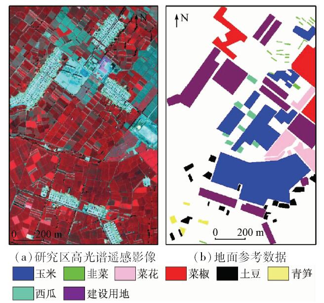
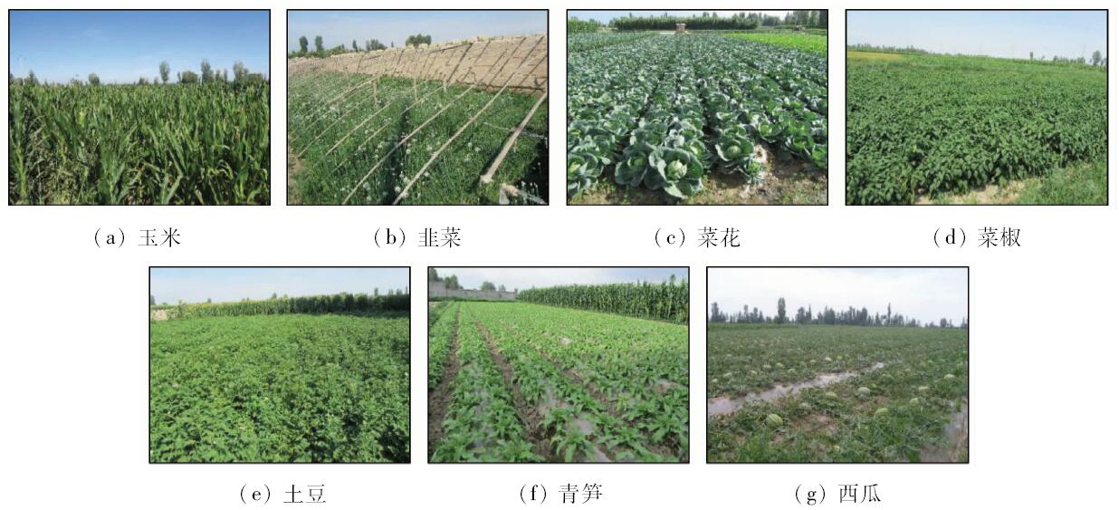
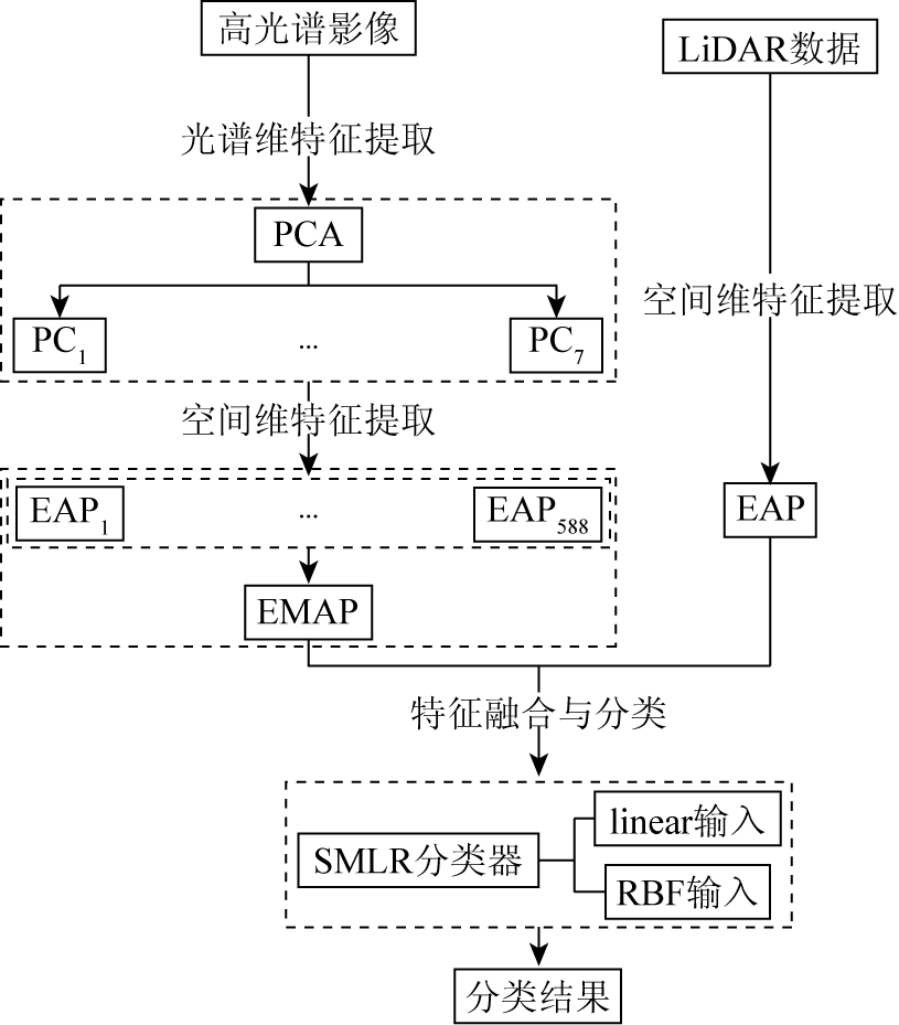
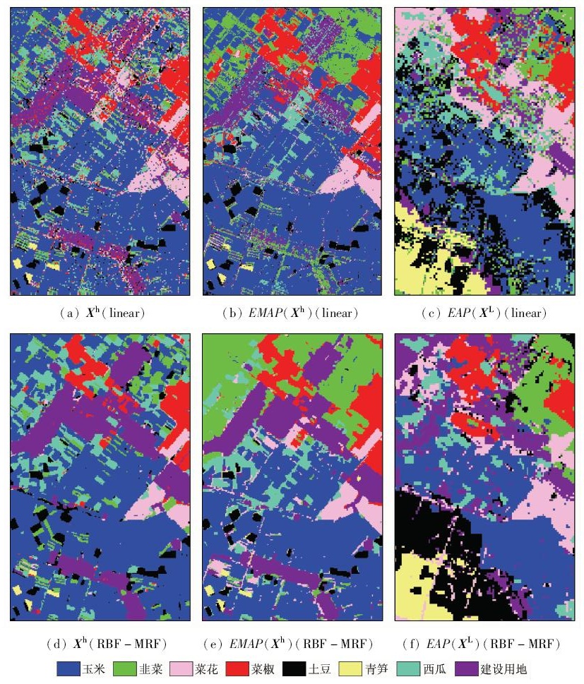
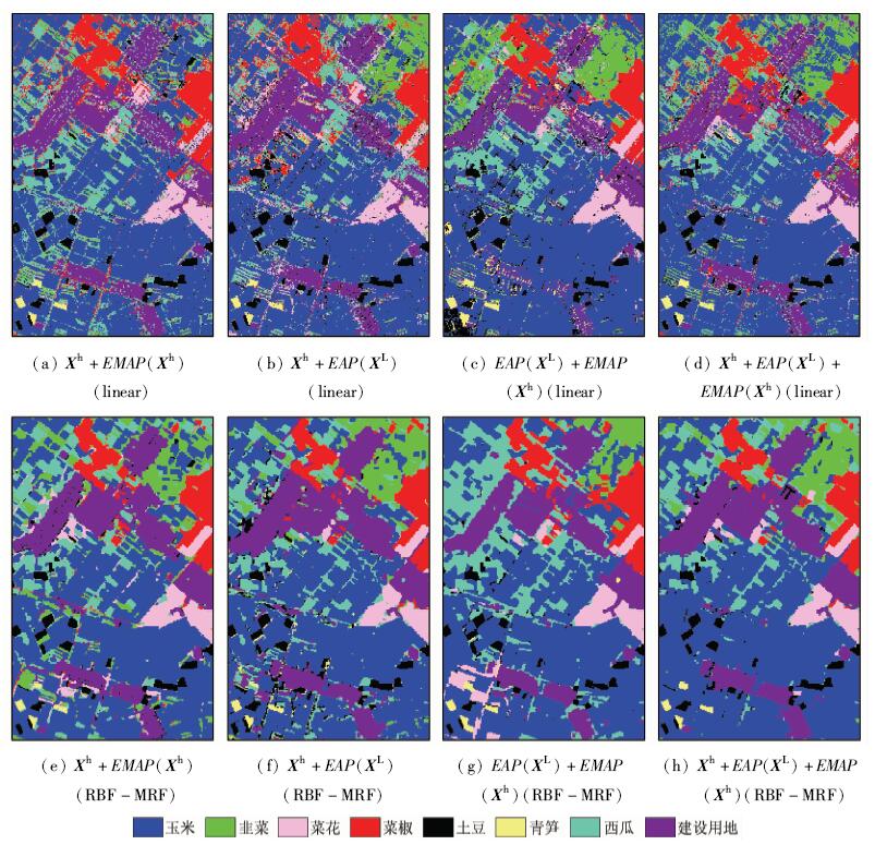
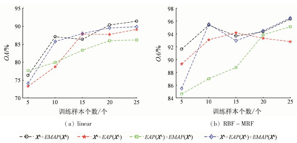
Hyperspectral remote sensing can simultaneously acquire spatial images of space and fine spectral information so as to describe the features more accurately. However, when the phenomena of different spectra in the same objects or the same spectra in different objects occur, the classification of hyperspectral images will face a daunting challenge. Light detection and ranging (LiDAR) can obtain the terrain topology information and can be used to construct the surface 3D model. However, features cannot be accurately identified by using LiDAR data only. Based on the above two points, the authors carried out a study to fuse hyperspectral images and LiDAR data. Morphological attribute profile was used to extract features, and sparse multinomial logistic regression (SMLR) was used to do classification. The fusion and classification effect in different combinations of characteristics were also investigated. The CASI/SASI aerial hyperspectral image and LiDAR DSM data were used to validate this method based on the Zhangye Oasis agricultural area in the middle reaches of the Heihe River which is a good target for the classification of crop. The results show that the method using hyperspectral and LiDAR data can obtain better classification results with higher accuracy and stability, and the best classification accuracy is 94.50% by fusion features based on the extended morphological attribute profile.
杨思睿, 薛朝辉, 张玲, 苏红军, 周绍光. 高光谱与LiDAR数据融合研究——以黑河中游张掖绿洲农业区精细作物分类为例[J]. 国土资源遥感, 2018, 30(4): 33-40.
Sirui YANG, Zhaohui XUE, Ling ZHANG, Hongjun SU, Shaoguang ZHOU. Fusion of hyperspectral and LiDAR data: A case study for refined crop classification in agricultural region of Zhangye Oasis in the middle reaches of Heihe River. Remote Sensing for Land & Resources, 2018, 30(4): 33-40.
Liu L J . Fused Airborne LiDAR and Hyperspectral Data for Tree Species Identification in a Natural Temperate Forest[D]. Harbin:Northeast Forestry University, 2011.
[4]
张小红 . 机载激光雷达测量技术理论与方法[M]. 武汉: 武汉大学出版社, 2007.
Zhang X H. Theory and Method of Airborne LiDAR Measurement Technology[M]. Wuhan: Wuhan University Press, 2007.
[5]
Pedergnana M, Marpu P R, Mura M D , et al. Classification of remote sensing optical and LiDAR data using extended attribute profiles[J]. IEEE Journal of Selected Topics in Signal Processing, 2012,6(7):856-865.
doi: 10.1109/JSTSP.2012.2208177
[6]
Ni L, Gao L R, Li S S , et al. Edge-constrained Markov random field classification by integrating hyperspectral image with LiDAR data overurban areas[J]. Journal of Applied Remote Sensing, 2014,8(1):205-207.
doi: 10.1117/1.JRS.8.085089
[7]
Zhang Y, Yang H L, Prasad S , et al. Ensemble multiple kernel active learning for classification of multisource remote sensing data[J]. IEEE Journal of Selected Topics in Applied Earth Observations and Remote Sensing, 2015,8(2):845-858.
doi: 10.1109/JSTARS.2014.2359136
[8]
Gu Y F, Wang Q W, Jia X P , et al. A novel MKL model of integrating LiDAR data and MSI for urban area classification[J]. IEEE Transactions on Geoscience and Remote Sensing, 2015,53(10):5312-5326.
doi: 10.1109/TGRS.2015.2421051
[9]
Liao W Z, Pizurica A, Bellens R , et al. Generalized graph-based fusion of hyperspectral and LiDAR data using morphological features[J]. IEEE Geoscienceand Remote Sensing Letters, 2015,12(3):552-556.
doi: 10.1109/LGRS.2014.2350263
[10]
Bigdeli B, Samadzadegan F, Reinartz P . Feature grouping-based multiple fuzzy classifier system for fusion of hyperspectral and LiDAR data[J].Journal of Applied Remote Sensing, 2014, 8(1):083509-1-15.
doi: 10.1117/1.JRS.8.083509
[11]
Bigdeli B, Samadzadegan F, Reinartz P . Fusion of hyperspectral and LiDAR data using decision template-based fuzzy multiple classifier system[J]. IEEE Journal of Applied Earth Observation and Geoinformation, 2015,38(1):309-320.
doi: 10.1016/j.jag.2015.01.017
[12]
Castrodad A, Khuon T, Rand R , et al. Sparse modeling for hyperspectral imagery with LiDAR data fusion for subpixel mapping[J]. IEEE International Geoscience and Remote Sensing Symposium, 2012,22(8):7275-7278.
doi: 10.1109/IGARSS.2012.6351982
[13]
Zhang Y, Prasad S . Multisource geospatial data fusion via local joint sparse representation[J]. IEEE Transactions on Geoscience Remote Sensing, 2016,54(6):3265-3276.
doi: 10.1109/TGRS.2016.2514481
[14]
Yokoya N, Nakazawa S, Matsuki T , et al. Fusion of hyperspectral and LiDAR data for landscape visual quality assessment[J]. IEEE Journal of Selected Topics in Signal Applied Earth Observations and Remote Sensing, 2014,7(6):2419-2425.
doi: 10.1109/JSTARS.2014.2313356
Dong Y F, Pang Y, Xu L N , et al. Feature extraction based on fusion of hyperspectral image and airborne LiDAR data[J]. Remote Sensing Information, 2014,29(6):73-76,83.
Li G H, Wang C, Xi X H , et al. Extraction of glacier snowline based on airborne LiDAR and hyperspectral data fusion[J]. Remote Sensing for Land and Resources, 2013,25(3):79-84.doi: 10.6046/gtzyyg.2013.03.14.
Li X, Liu S M, Ma M G , et al. HiWATER:An integrated remote sensing experiment on hydrological and ecological processes in the Heihe River Basin[J]. Advances in Earth Science, 2012,27(5):481-498.
Jiao Y M, Ma M G, Xiao D N . Research on the landscape pattern of Zhangye Oasis in the middle reaches of Heihe River[J]. Journal of Glaciology and Geocryology, 2003,25(1):94-99.
[20]
薛朝辉 . 高光谱遥感影像稀疏图嵌入分类研究[D]. 南京:南京大学, 2015.
Xue Z H . Hyperspectral Remote Sensing Image Classification via Sparse Graph Embedding[D]. Nanjing:Nanjing University, 2015.
Zhang M, Jiang Z R, Ma M G , et al. Fine classification of planting structure in the middle reaches of Heihe River Basin based on hyperspectral compace airborne spectrographic imager(CASI) data[J]. Remote Sensing Technology and Application, 2013,28(2):283-289.
Yang Y W, Dai X A, Niu Y T , et al. Inversion of leaf area index in Heihe Oasis based on CASI data[J]. Remote Sensing for Land and Resources, 2017,29(4):179-184.doi: 10.6046/gtzyyg.2017.04.27.
 2018, Vol. 30
  ), 张玲2, 苏红军1, 周绍光1