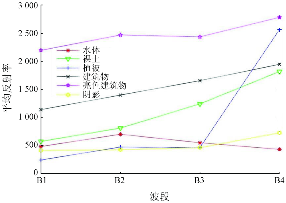
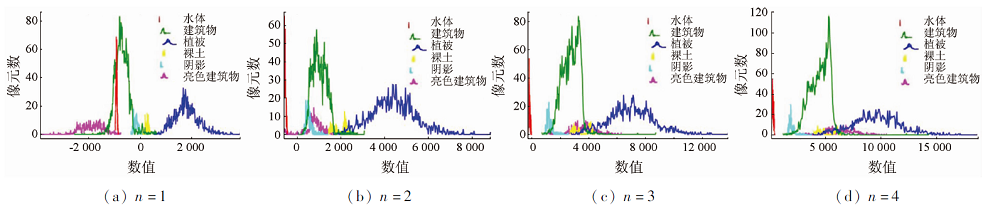
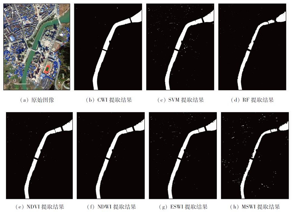
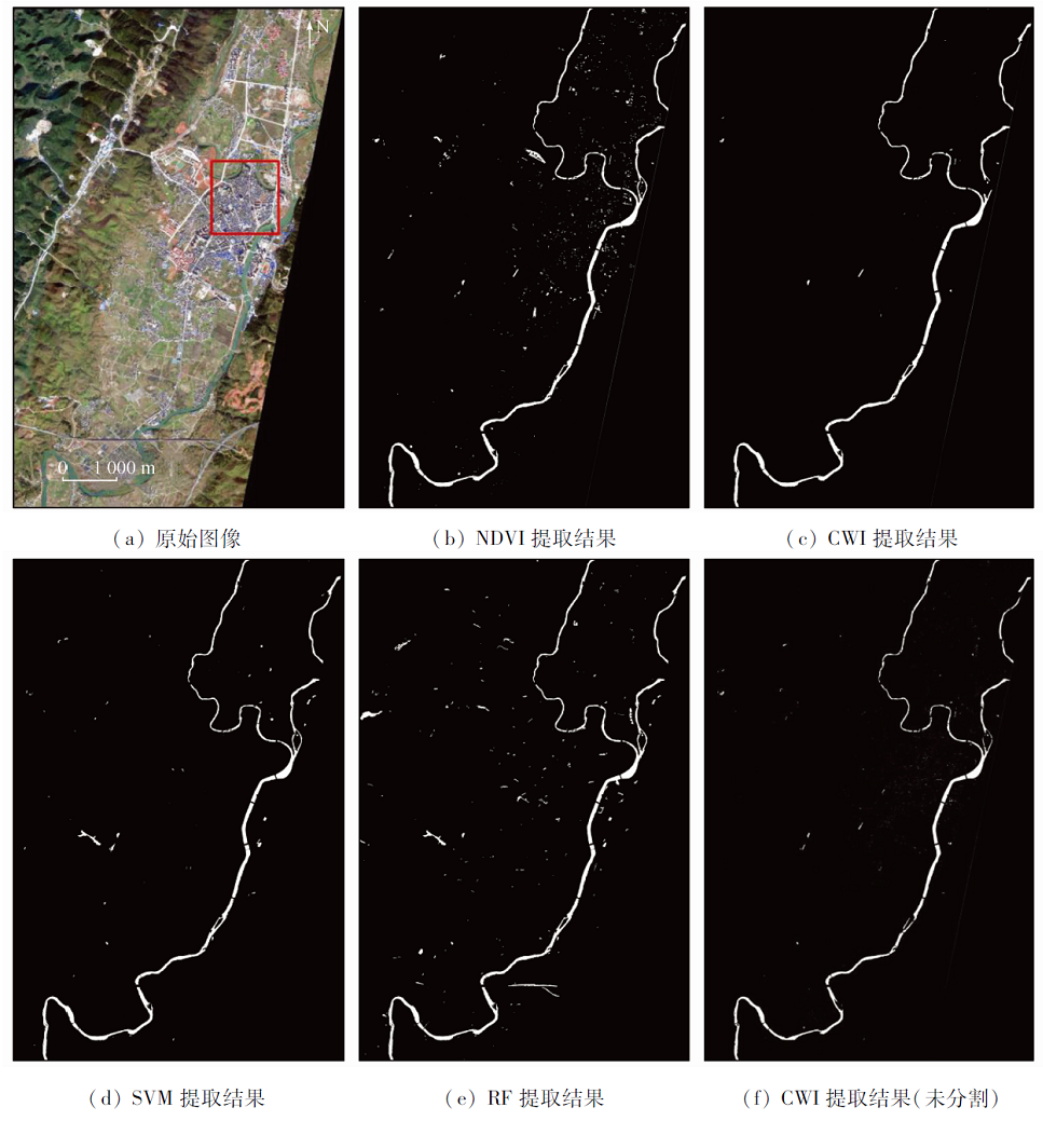
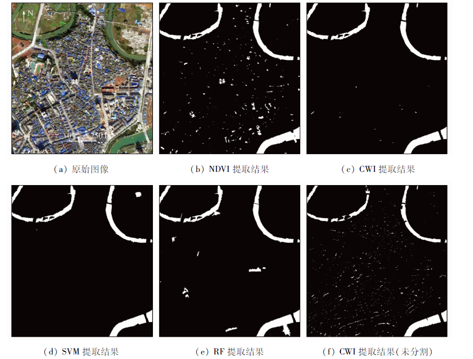
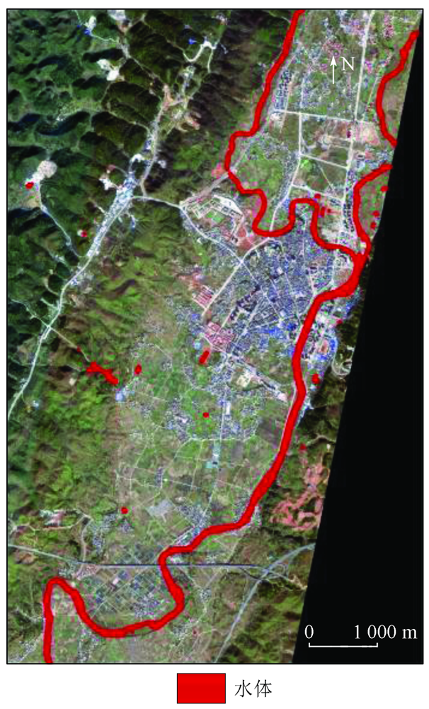
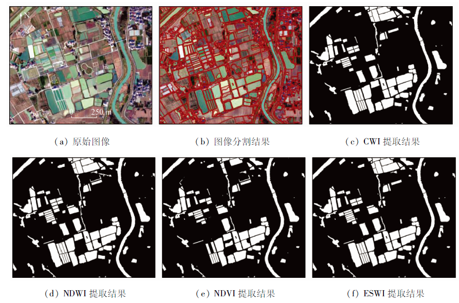
The high spatial resolution of GF-2 images helps to obtain more accurate water distribution information. This study constructed a water index based on GF-2 images and verified it, aiming to solve the problem that the salt and pepper noise is prone to occur when the existing water indices are used to extract information on water bodies in complex environments from high-resolution remote sensing images. Firstly, this study established a comprehensive water index (CWI) by analyzing the spectral information of surface coverings and verified its precision. Secondly, information on water bodies was extracted through image segmentation combined with the CWI, and the extraction precision was verified. Then, to fully utilize the spectral information and the advantages of a classifier, the spectral information on the segmented homogeneous objects and the CWI were combined as the input data of the classifier to extract information on water bodies and verify the extraction precision. Finally, this study verified the applicability of the CWI in both WorldView-2 and GF-1 images. The results are as follows. ① The newly constructed CWI can effectively suppress the impacts of surface coverings, such as shadow, buildings, roads, vegetation, and bare soil, thus significantly improving the extraction precision. ② Extracting information on water bodies through image segmentation combined with the CWI can effectively inhibit the occurrence of the pepper and salt noise. ③ A classifier combined with a water index can effectively improve the information extraction precision of water bodies. ④ The CWI is applicable to both WorldView-2 and GF-1 images. In sum, the CWI can be used to effectively extract information on water bodies and applies to the information extraction and renewal of rivers and lakes and the surveys of the cultivation area of pounds and thereby is a high-precision method for extraction information of water bodies.
王春霞, 张俊, 李屹旭, Phoumilay. 复杂环境下GF-2影像水体指数的构建及验证[J]. 自然资源遥感, 2022, 34(3): 50-58.
WANG Chunxia, ZHANG Jun, LI Yixu, PHOUMILAY. The construction and verification of a water index in the complex environment based on GF-2 images. Remote Sensing for Natural Resources, 2022, 34(3): 50-58.
Yang C J, Wei Y M, Wang S Y, et al. Extracting the flood extent from satellite SAR image with the support of topographic data[C]// International Conferences on Info-Tech and Info-Net.IEEE Computer Society, 1998.
He H S, Huang X X, Li H G, et al. Water body extraction of high resolution remote sensing image basedon improved U-Net network[J]. Journal of Geo-Information Science, 2020, 22(10):2010-2022.
Liang Z Y, Wu Y L, Yang H, et al. Full-automatic water extraction method for remote sensing image based on densely connected full convolutional neural network[J]. Remote Sensing Information, 2020, 35(4):68-77
Chen Q, Zheng L J, Li X J, et al. Water boby extraction form high-resolution satellite remote sensing images based on deep learning[J]. Geography and Geo-Information Science, 2019, 35(4):43-49.
[5]
Gulcan S, Mehmet O. Water body extraction and change detection using time series: A case study of Lake Burdur,Turkey[J]. Journal of Taibah University for Science, 2017, 11(3):381-391.
doi: 10.1016/j.jtusci.2016.04.005
Wang J J, Ding J L, Zhang C, et al. Method of water information extraction by improved SWI based on GF-1 satellite image[J]. Remote Sensing for Land and Resources, 2017, 29(1):29-35.doi: 10.6046/gtzyyg.2017.01.05.
doi: 10.6046/gtzyyg.2017.01.05
Mao Y Y, Chen Y F. Water body extraction method based on object-oriented in mountainous area with Landsat8 image[J]. Journal of Subtropical Resources and Environment, 2015, 10(4):86-92.
Hu W G, Meng L K, Zhang D Y, et al. Method of water extraction from ZY-1 02C satellite image[J]. Remote Sensing for Land and Resources, 2014, 26(2):43-47.doi: 10.6046/gtzyyg.2014.02.08.
doi: 10.6046/gtzyyg.2014.02.08
Wang X B, Xie S P, Du J K. Water index formulation and its effectiveness research on the complicated surface water surroundings[J]. Journal of Remote Sensing, 2018, 22(2): 360-372.
Yang S W, Li Y K, Liu T, et al. A new automatic water boby feature extraction method based on SPOT5 images[J]. Geomatics and Information Science of Wuhan University, 2015, 40(3):308-314.
[11]
Gudina L F, Henrik M, Rasmus F, et al. Automated water extraction index:A new technique for surface water mapping using Landsat imagery[J]. Remote Sensing of Environment, 2014, 140(1):23-35.
doi: 10.1016/j.rse.2013.08.029
Shen Z F, Xia L G, Li J L, et al. Automatic and high-precision extraction of rivers from remotely sensed images with Gaussian normalized water index[J]. Journal of Image and Graphics, 2013, 18(4):421-428.
Xu H Q. A study on information extraction of water body with the modified normalized difference water index (MNDWI)[J]. Journal of Remote Sensing, 2005, 9(5):589-595.
[14]
Rogers A S, Kearney M S. Reducing signature variability in unmixing coastal marsh thematic mapper scenes using spectral indices[J]. International Journal of Remote Sensing, 2004, 25(12):2317-2335.
doi: 10.1080/01431160310001618103
[15]
McFEETERS S K. The use of the normalized difference water index (NDWI) in the delineation of open water features[J]. International Journal of Remote Sensing, 1996, 17(7):1425-1432.
doi: 10.1080/01431169608948714
Duan J W, Zhong J S, Jiang L, et al. Extraction method of ultra-green water index for flood area after rain based on GF-2 image[J]. Geography and Geo-Information Science, 2021, 37(3):35-41.
Zhou C, Yang X Z, Dong Z Y, et al. A fast water information extraction method based on GF-2 remote sensing image[J]. Journal of Graphics, 2019, 40(1):99-104.
Gu J Y, Yan M, Zhang X J, et al. Research on the method of extracting water information from gaofen-1 image[J]. Agriculture and Technology, 2018, 38(11):24-26,109.
Chen W Q, Ding J L, Li Y H, et al. Extraction of water information based on China-made GF-1 remote sense image[J]. Resources Science, 2015, 37(6):1166-1172.
Wand D M, Chen L, Feng F. Study on water information extraction from GF-2 image based on object-oriented method[J]. Yellow River, 2021, 43(5):80-83,90.
Huang S, Ding J L, Li Y H. Study of water information extraction based on domestic GF-1 remote sensing image by using object-oriented method[J]. Yangtze River, 2016, 47(5):23-28.
Hong L, Huang Y J, Yang K, et al. Study on urban surface water extraction from heterogeneous environments using GF-2 remotely sensed images[J]. Journal of Remote Sensing, 2019, 23(5): 871-882.
Wang S L. Large-scale and long-time water quality remote sensing monitoring over lakes based on water color index[D]. Beijing: University of Chinese Academy of Sciences, 2018.
Duan Q Y, Meng L K, Fan Z W, et al. Applicability of the water information extraction method based on GF-1 image[J]. Remote Sensing for Land and Resources, 2015, 27(4):79-84.doi: 10.6046/gtzyyg.2015.04.13.
doi: 10.6046/gtzyyg.2015.04.13
[25]
Jain S K, Singh R D, Jain M K, et al. Delineation of flood-prone areas using remote sensing techniques[J]. Water Resources Management, 2005, 19(4):333-347.
doi: 10.1007/s11269-005-3281-5
[26]
Zhang F, Li J, Zhang B, et al. A simple automated dynamic thresho-ld extraction method for the classification of large water bodies from Landsat8 OLI water index images[J]. International Journal of Remote Sensing, 2018, 39(11):3429-3451.
doi: 10.1080/01431161.2018.1444292
[27]
Fieuzal R, Sicre C M, Baup F. Estimation of corn yield using multi-temporal optical and Radar satellitedata and artificial neural networks[J]. International Journal of Applied Earth Observation and Geoinformation, 2017, 57(1):14-23.
doi: 10.1016/j.jag.2016.12.011
Liu S T, Wang M X, Yang S W, et al. Research on water body extraction method based on GF-2 high resolution remote sensing image[J]. GNSS World of China, 2018, 43(6):37-43.
 2022, Vol. 34
  ), 张俊1(