Please wait a minute...
 
自然资源遥感  2022, Vol. 34 Issue (3): 59-64    DOI: 10.6046/zrzyyg.2021279
  技术方法 本期目录 | 过刊浏览 | 高级检索 |
一种与遥感影像同步纠正的矢量地理信息采集方法
程滔()
国家基础地理信息中心,北京 100830
A method for vector geographic information acquisition based on synchronous correction with remote sensing images
CHENG Tao()
National Geomatics Center of China, Beijing 100830, China
全文: PDF(2873 KB)   HTML  
输出: BibTeX | EndNote (RIS)      
摘要 

针对现有的基于遥感影像的矢量地理信息采集存在的局限性,提出一种随遥感影像同步纠正的矢量地理信息采集方法。首先不对原始遥感影像进行高精度正射纠正处理,矢量地理信息采集直接基于原始遥感影像进行; 待矢量地理信息采集完成后,再对原始遥感影像进行高精度正射纠正处理; 同时,将矢量地理信息成果按照原始遥感影像正射纠正同一模型、同步纠正,实现遥感影像与矢量地理信息空间坐标系的一致、同步。一方面解决外业调查核查过程中存在的数据安全隐患问题,另一方面有利于改善现有生产工艺流程,提高地理信息采集的时效性。选取平地和山地2种典型地形实验区,以WorldView-2遥感影像为数据源,采用提出的方法实现了矢量地理信息采集。结果表明: 该方法能够保证成果空间定位精度基本满足要求,并能有效解决现有的改进技术方法中可能产生的要素交叉与缝隙问题。

服务
把本文推荐给朋友
加入引用管理器
E-mail Alert
RSS
作者相关文章
程滔
关键词 矢量遥感影像纠正RPC工艺流程    
Abstract

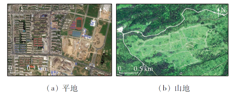
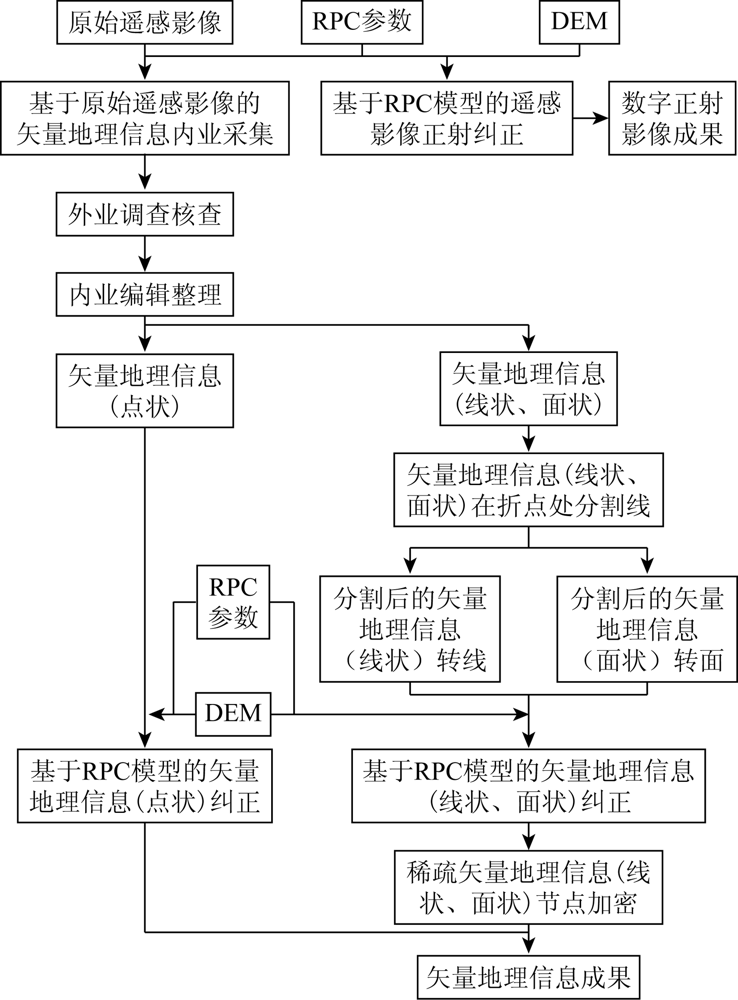
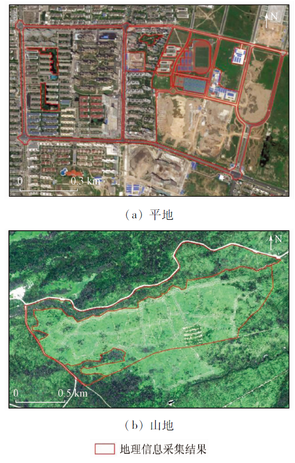
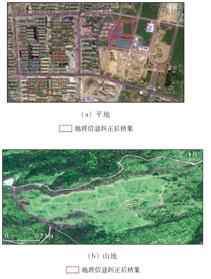
Given the limitations in the existing vector geographic information acquisition based on remote sensing images, this study proposed a new method, in which the vector geographic information is orthorectified synchronously with remote sensing images. Firstly, the original remote sensing images are no longer processed using high-precision orthorectification, and vector geographic information acquisition is directly carried out based on the original remote sensing images. The original remote sensing images are processed using high-precision orthorectification after the vector geographic information acquisition. Moreover, the vector geographic information is synchronously corrected using the same model based on the original remote sensing images, thus achieving the consistency and synchronization between the remote sensing images and vector geographic information. This method can eliminate the potential risks in data security in the process of field investigation and can help optimize the existing production process and improve the timeliness of vector geographic information acquisition. Taking WorldView-2 remote sensing images as the data source, this study performed the vector geographic information acquisition of two selected typical types of terrain, i.e., plain and mountain, using this method. The results show that this method can ensure that the spatial positioning accuracy of the results can roughly meet relevant requirements and can effectively address the problems of the feature intersection and gaps possibly occurring in the existing improved techniques and methods.

Key wordsvector    remote sensing image    correction    RPC    process flow
收稿日期: 2021-09-03      出版日期: 2022-09-21
ZTFLH:  P237  
  TP391.4  
基金资助:自然资源调查监测评价和自然资源(不动产)确权登记项目“地理国情监测”(22-30-01-1)
作者简介: 程 滔(1981-),男,硕士,高级工程师,主要从事自然资源调查监测技术研究、遥感信息提取与变化监测方法研究、摄影测量与遥感影像数据处理与应用开发等工作。Email: chengtao@ngcc.cn
引用本文:   
程滔. 一种与遥感影像同步纠正的矢量地理信息采集方法[J]. 自然资源遥感, 2022, 34(3): 59-64.
CHENG Tao. A method for vector geographic information acquisition based on synchronous correction with remote sensing images. Remote Sensing for Natural Resources, 2022, 34(3): 59-64.
链接本文:  
https://www.gtzyyg.com/CN/10.6046/zrzyyg.2021279      或      https://www.gtzyyg.com/CN/Y2022/V34/I3/59
Fig.1  WorldView-2 B5(R),B3(G),B2(B)合成影像
Fig.2  本文方法流程图
Fig.3  矢量地理信息采集结果
(底图为原始遥感影像)
Fig.4  矢量地理信息纠正结果
(底图为数字正射影像)
[1] 唐新明, 王鸿燕. 资源三号卫星应用分析与展望[J]. 航天器工程, 2016, 25(5):1-10.
Tang X M, Wang H Y. Analysis and prospect of application of ZY-3 satellite[J]. Spacecraft Engineering, 2016, 25(5):1-10.
[2] 国务院第一次全国地理国情普查领导小组办公室. 地理国情普查数据采集技术方法[M]. 北京: 测绘出版社, 2013:1-76.
Office of The Leading Group for The First National Geographic Condition Investigation. Technology and method of data collection in national geographic condition investigation[M]. Beijing: SinoMaps Press, 2013:1-76.
[3] 王西萍, 许存玲, 李若, 等. 地理信息数字成果采编一体化流程实现[J]. 测绘标准化, 2017, 33(1):15-17.
Wang X P, Xu C L, Li R, et al. Implementation of collecting and editing integration in the production of geographic information data[J]. Standardization of Surveying and Mapping, 2017, 33(1):15-17.
[4] 程滔, 周旭, 贾云鹏. 地理国情监测与基础测绘联合生产外业作业系统设计思考[J]. 地理信息世界, 2018, 28(4):202-206.
Cheng T, Zhou X, Jia Y P. Design consideration of field surveying system for joint production of geographic national conditions monitoring and basic surveying and mapping[J]. Geomatics World, 2018, 28(4):202-206.
[5] 李虎, 朱恒华, 花卫华, 等. 矢量地理数据安全保护关键技术和方法[J]. 地球科学, 2020, 45(12):4574-4588.
Li H, Zhu H H, Hua W H, et al. Key technologies and methods for vector geographic data security protection[J]. Earth Science, 2020, 45(12):4574-4588.
[6] 王占宏, 吴满意, 田怀启, 等. 单片调绘矢量数据的正射纠正[J]. 测绘通报, 2017(2):75-78.
Wang Z H, Wu M Y, Tian H Q, et al. Ortho-rectification for annotation vector data of single chip image[J]. Bulletin of Surveying and Mapping, 2017(2):75-78.
[7] 申学林, 李见阳, 陈勇, 等. 基于粗纠正卫星影像源进行1∶5万DLG生产“一体化”工艺流程的探索[J]. 测绘, 2009, 32(3):130-132.
Shen X L, Li J Y, Chen Y, et al. The technical exploration of 1∶50 000 database integrative produce based on rough corrective rsdom[J]. Surveying and Mapping, 2009, 32(3):130-132.
[8] 王春波. 浅谈基于粗纠正影像源进行1∶10 000 DLG生产“内外业一体化”工艺流程[J]. 测绘与空间地理信息, 2012, 35(4):178-179.
Wang C B. Discussion on integrated mapping technique for field and indoor work to produce 1∶10 000 DLG based on rough corrective images[J]. Geomatics and Spatial Information Technology, 2012, 35(4):178-179.
[9] 秦绪文, 田淑芳, 洪友堂, 等. 无需初值的RPC模型参数求解算法研究[J]. 国土资源遥感, 2005, 17(4):7-10,15.doi: 10.6046/gtzyyg.2005.04.02.
doi: 10.6046/gtzyyg
Qin X W, Tian S F, Hong Y T, et al. The algorithm for parameters of RPC model without initial value[J]. Remote Sensing for Land and Resources, 2005, 17(4):7-10,15.doi: 10.6046/gtzyyg.2005.04.02.
doi: 10.6046/gtzyyg
[10] 王海侠, 高飞, 胡小华. 基于RPC模型的QuickBird影像正射纠正研究[J]. 现代测绘, 2010, 33(6):13-15.
Wang H X, Gao F, Hu X H. The research about QuickBird images ortho-rectification based on RPC models[J]. Modern Surveying and Mapping, 2010, 33(6):13-15.
[11] 巩丹超, 张永生. 有理函数模型的解算与应用[J]. 测绘学院学报, 2003, 20(1):39-46.
Gong D C, Zhang Y S. The solving and application of rational function model[J]. Journal of Institute of Surveying and Mapping, 2003, 20(1):39-46.
[12] 张过, 李德仁. 卫星遥感影像RPC参数求解算法研究[J]. 中国图象图形学报, 2007, 12(12):2081-2088.
Zhang G, Li D R. The algorithm of computation RPC model’s parameters for satellite imagery[J]. Journal of Image and Graphics, 2007, 12(12):2081-2088.
[13] 刘军, 王冬红, 毛国苗. 基于RPC模型的IKONOS卫星影像高精度立体定位[J]. 测绘通报, 2004(9):1-3.
Liu J, Wang D H, Mao G M. High precision stereo positioning of IKONOS satellite images based on RPC model[J]. Bulletin of Surveying and Mapping, 2004(9):1-3.
[14] 张永生, 刘军. 高分辨率遥感卫星立体影像RPC模型定位的算法及其优化[J]. 测绘工程, 2004, 13(1):1-4.
Zhang Y S, Liu J. The positioning algorithm based on RPC model and its optimizing of stereo images from high resolution remote sensing satellites[J]. Engineering of Surveying and Mapping, 2004, 13(1):1-4.
[15] 陈静波, 宋伟东. 基于有理函数模型的IKONOS单片正射纠正方法研究[J]. 测绘工程, 2008, 17(5):19-22.
Chen J B, Song W D. Research on orthorectification of IKONOS single photo based on rational function model[J]. Engineering of Surveying and Mapping, 2008, 17(5):19-22.
[1] 刁明光, 刘勇, 郭宁博, 李文吉, 江继康, 王云霄. 基于Mask R-CNN的遥感影像疏林地智能识别方法[J]. 自然资源遥感, 2023, 35(2): 97-104.
[2] 赵凌虎, 袁希平, 甘淑, 胡琳, 丘鸣语. 改进Deeplabv3+的高分辨率遥感影像道路提取模型[J]. 自然资源遥感, 2023, 35(1): 107-114.
[3] 沈骏翱, 马梦婷, 宋致远, 柳汀洲, 张微. 基于深度学习语义分割模型的高分辨率遥感图像水体提取[J]. 自然资源遥感, 2022, 34(4): 129-135.
[4] 吕雅楠, 朱红, 孟健, 崔成玲, 宋其淇. 面向高分辨率遥感影像车辆检测的深度学习模型综述及适应性研究[J]. 自然资源遥感, 2022, 34(4): 22-32.
[5] 唐文魁, 俞露, 周伟奇, 岳隽, 周正. 基于长时间序列遥感数据的深圳景观连通性动态变化研究[J]. 自然资源遥感, 2022, 34(3): 97-105.
[6] 马御棠, 潘浩, 周仿荣, 黄然, 赵加能, 罗继强, 刘靖, 孙浩轩, 贾伟洁, 张涛. 基于卫星影像的输电杆塔坐标校准方法[J]. 自然资源遥感, 2022, 34(2): 63-71.
[7] 苏赋, 于海鹏, 朱威西. 标签聚类损失在遥感影像分类中的应用[J]. 自然资源遥感, 2022, 34(2): 144-151.
[8] 薛白, 王懿哲, 刘书含, 岳明宇, 王艺颖, 赵世湖. 基于孪生注意力网络的高分辨率遥感影像变化检测[J]. 自然资源遥感, 2022, 34(1): 61-66.
[9] 宋仁波, 朱瑜馨, 郭仁杰, 赵鹏飞, 赵珂馨, 朱洁, 陈颖. 基于多源数据集成的城市建筑物三维建模方法[J]. 自然资源遥感, 2022, 34(1): 93-105.
[10] 赵晓晨, 吴皓楠, 李林宜, 孟令奎. 面向汛旱情监测的遥感影像GPU并行处理算法[J]. 自然资源遥感, 2021, 33(3): 107-113.
[11] 桑潇, 张成业, 李军, 朱守杰, 邢江河, 王金阳, 王兴娟, 李佳瑶, 杨颖. 煤炭开采背景下的伊金霍洛旗土地利用变化强度分析[J]. 自然资源遥感, 2021, 33(3): 148-155.
[12] 王译著, 黄亮, 陈朋弟, 李文国, 余晓娜. 联合显著性和多方法差异影像融合的遥感影像变化检测[J]. 自然资源遥感, 2021, 33(3): 89-96.
[13] 卢麒, 秦军, 姚雪东, 吴艳兰, 朱皓辰. 基于多层次感知网络的GF-2遥感影像建筑物提取[J]. 国土资源遥感, 2021, 33(2): 75-84.
[14] 胡苏李扬, 李辉, 顾延生, 黄咸雨, 张志麒, 汪迎春. 基于高分辨率遥感影像的神农架大九湖湿地土地利用类型变化及其驱动力分析——来自长时间尺度多源遥感信息的约束[J]. 国土资源遥感, 2021, 33(1): 221-230.
[15] 刘钊, 赵桐, 廖斐凡, 李帅, 李海洋. 基于语义分割网络的高分遥感影像城市建成区提取方法研究与对比分析[J]. 国土资源遥感, 2021, 33(1): 45-53.
Viewed
Full text


Abstract

Cited

  Shared   
  Discussed   
京ICP备05055290号-2
版权所有 © 2015 《自然资源遥感》编辑部
地址:北京学院路31号中国国土资源航空物探遥感中心 邮编:100083
电话:010-62060291/62060292 E-mail:zrzyyg@163.com
本系统由北京玛格泰克科技发展有限公司设计开发