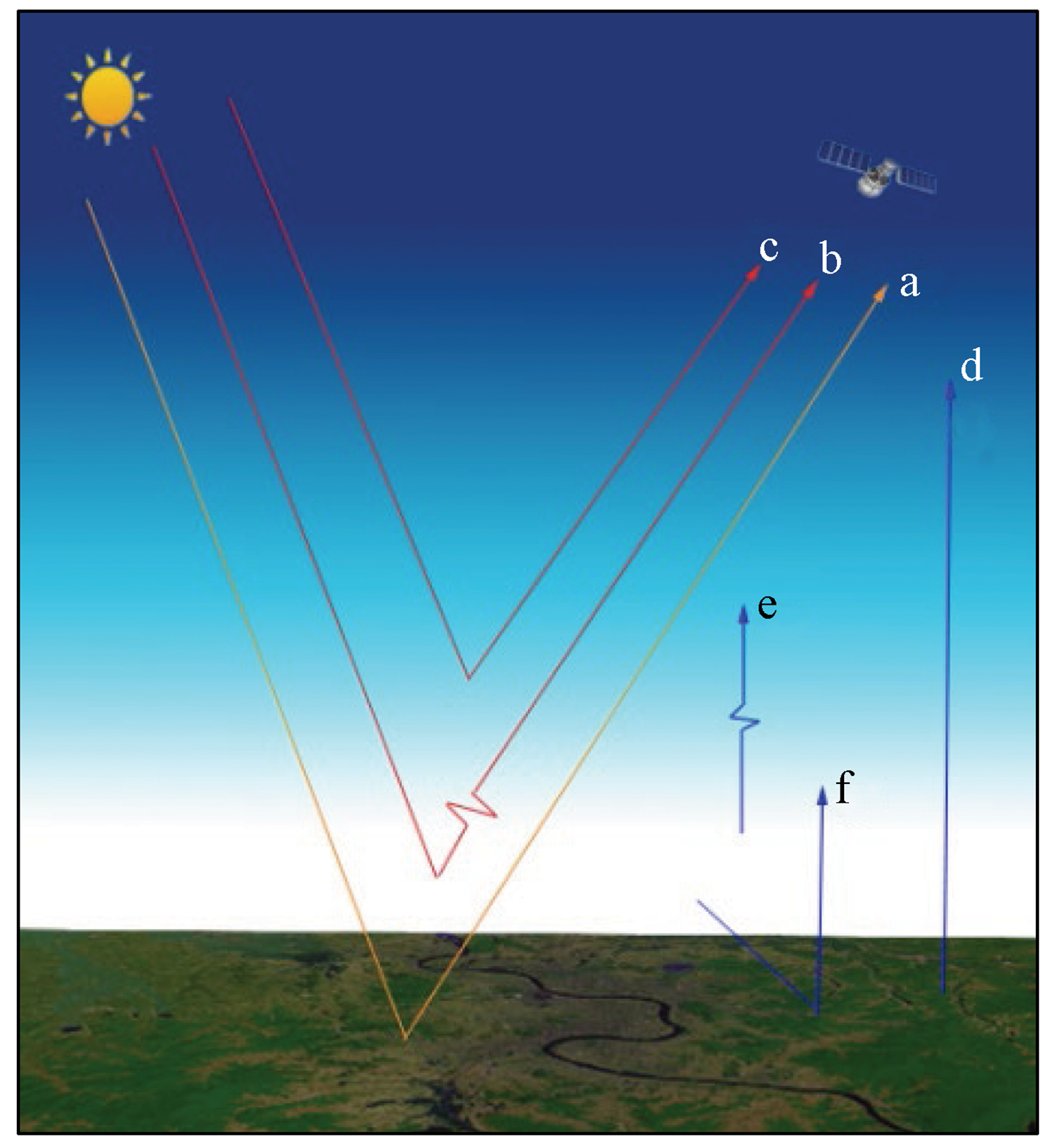
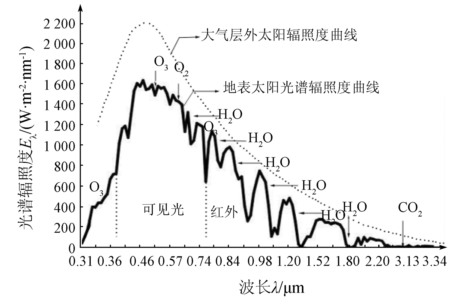
Atmospheric correction is an important preprocessing step for hyperspectral remote sensing images. The atmospheric correction quality determines the application degree of hyperspectral remote sensing to a certain extent. First, this study analyzed the influence of the atmosphere on radiative transfer and summarized the inversion methods of aerosol optical thickness and water vapor in the atmosphere, indicating the main atmospheric factors affecting the quality of hyperspectral remote sensing images. Then, the influence of the atmosphere was demonstrated theoretically by clarifying the derivation process of the radiative transfer equation and the action mechanism of relevant parameters, indicating the main aspects of hyperspectral atmospheric correction. Furthermore, this study summarized the hyperspectral atmospheric correction methods formed in recent years, including methods based on empirical statistics and radiative transfer, and analyzed the study advances and development trends of hyperspectral atmospheric correction. Finally, this study forecasted the development of atmospheric correction of hyperspectral remote sensing images. This study will provide a certain reference for the engineering application and study of hyperspectral remote sensing.
孔卓, 杨海涛, 郑逢杰, 李扬, 齐济, 朱沁雨, 杨忠霖. 高光谱遥感图像大气校正研究进展[J]. 自然资源遥感, 2022, 34(4): 1-10.
KONG Zhuo, YANG Haitao, ZHENG Fengjie, LI Yang, QI Ji, ZHU Qinyu, YANG Zhonglin. Research advances in atmospheric correction of hyperspectral remote sensing images. Remote Sensing for Natural Resources, 2022, 34(4): 1-10.
Tao W. Urban feature identification and classification based on Hyperion hyperspectral remote sensing data[D]. Hangzhou: Zhejiang University, 2013.
[2]
Sedaghat A, Mokhtarzade M, Ebadi H. Uniform robust scale-invariant feature matching for optical remote sensing images[J]. IEEE Transactions on Geoscience and Remote Sensing, 2011, 49(11):4516-4527.
doi: 10.1109/TGRS.2011.2144607
[3]
赵英时. 遥感应用分析原理与方法[M]. 北京: 科学出版社, 2004:8-9,161-162.
Zhao Y S. The principle and method of analysis of remote sensing application[M]. Beijing: Science Press, 2004:8-9,161-162.
Tong Q X, Zhang B, Zheng L F. Hyperspectral remote sensing[M]. Beijing: Higher Education Press, 2006:67-69.
[5]
Schaepman M E, Ustin S L, Plaza A J, et al. Earth system science related imaging spectroscopy:An assessment[J]. Remote Sensing of Environment, 2009, 113(s1):123-137.
[6]
梅安新, 彭望琭, 秦其明, 等. 遥感导论[M]. 北京: 高等教育出版社, 2001:8-9.
Mei A X, Peng W L, Qin Q M, et al. Introduction to remote sensing[M]. Beijing: Higher Education Press, 2001:8-9.
[7]
周婷婷. 遥感影像辐射校正研究与应用[D]. 福州: 福建师范大学, 2010.
Zhou T T. Research and applications of remote sensing radiometric correction[D]. Fuzhou: Fujian Normal University, 2010.
[8]
Goetz A, Vane G, Solomon J E, et al. Imaging spectrometry for earth remote sensing[J]. Science, 1985, 228(4704):1147-1153.
pmid: 17735325
[9]
Katse V I L, Prikhach A S, Zege E P, et al. A robust atmospheric correction procedure for determination of spectral reflectance of terrestrial surfaces from satellite spectral measurements[J]. Remote Sensing, 2021, 13(9):1831.
doi: 10.3390/rs13091831
Wang H T, Wang Y, Yuan Q Q. Validation and spatiotemporal analysis of MODIS multi-angle atmospheric calibration aerosol products in China from 2008 to 2016[J]. Remote Sensing Technolo-gy and Application, 2021, 36(1):1-12.
Huang H L, Ti R F, Zhang D Y, et al. Inversion of aerosol optical depth over land from directional polarimetric camera onboard Chinese Gaofen-5 satellite[J]. Journal of Infrared and Millimeter Waves, 2020, 39(4):454-461.
[12]
Levy R C, Remer L A, Mattoo S, et al. Second-generation operational algorithm:Retrieval of aerosol properties over land from inversion of moderate resolution imaging spectroradiometer spectral reflectance[J]. Journal of Geophysical Research Atmospheres, 2007, 112:D13211.
[13]
Diner D J, Martonchik J V, Kahn R A, et al. Using angular and spectral shape similarity constraints to improve MISR aerosol and surface retrievals over land[J]. Remote Sensing of Environment, 2005, 94(2):155-171.
doi: 10.1016/j.rse.2004.09.009
Wang Z T, Li Q, Wang Q, et al. HJ-1 terrestrial aerosol data retrieval using deep blue algorithm[J]. Journal of Remote Sensing, 2012, 16(3):596-610.
[15]
Schlaepfer D, Borel C C, Keller J, et al. Atmospheric precorrected differential absorption technique to retrieve columnar water vapor[J]. Remote Sensing of Environment, 1998, 65(3):353-366.
doi: 10.1016/S0034-4257(98)00044-3
[16]
Suomalainen J, Oliveira R A, Hakala T, et al. Direct reflectance transformation methodology for drone-based hyperspectral imaging[J]. Remote Sensing of Environment, 2021, 266:112691.
doi: 10.1016/j.rse.2021.112691
[17]
Schott J R. Remote sensing:The image chain approach[M]. Oxford University Press on Demand, 2007:42-56.
Mao K B, Qin Z H. The transmission model of atmospheric radiation and the computation of transmittance of MODTRAN[J]. Geomatics and Spatial Information Technology, 2004(4):1-3.
[19]
Ran W A, Jagab C, Rm A, et al. Errors associated with atmospheric correction methods for airborne imaging spectroscopy: Implications for vegetation indices and plant traits[J]. Remote Sensing of Environment, 2021, 265:112663.
doi: 10.1016/j.rse.2021.112663
[20]
Kruse F A. Comparison of ATREM, ACORN, and FLAASH atmospheric corrections using low-altitude AVIRIS data of Boulder,CO[C]// Proceedings 13th JPL Airborne Geoscience Workshop. Pasadena: JPL Publication, 2004.
[21]
Pathak V N, Pandya M R, Shah D B, et al. Inter comparison of atmospheric correction models-SACRS2, FLAASH and 6SV using resourcesat-2 AWiFS data[C]// International Archives of the Photogrammetry,Remote Sensing and Spatial Information Sciences, 2014:881-884.
Liu Z Q, Zhao S H, Pei L, et al. Precision evaluation on atmospheric correction reflectance of GF-5 satellite hyperspectral data[J]. Remote Sensing Information, 2021, 36(3):93-98.
[24]
Kruse F A. Use of airborne imaging spectrometer data to map minerals associated with hydrothermally altered rocks in the northern grapevine mountains,Nevada,and California[J]. Remote Sensing of Environment, 1988, 24(1):31-51.
doi: 10.1016/0034-4257(88)90004-1
[25]
Roberts D A, Yamaguchi Y, Lyon R. Comparison of various techniques for calibration of AIS data[C]// Proceedings of 2nd AIS workshop, Pasadena: JPL Publication 86-35, 1986:21-30.
[26]
Teillet P M, Fedosejevs G. On the dark target approach to atmospheric correction of remotely sensed data[J]. Canadian Journal of Remote Sensing, 1995, 21(4):374-387.
doi: 10.1080/07038992.1995.10855161
[27]
Hall F G, Strebel D E, Nickeson J E, et al. Radiometric rectification: Toward a common radiometric response among multidate, multisensor images[J]. Remote Sensing of Environment, 1991, 35(1):11-27.
doi: 10.1016/0034-4257(91)90062-B
[28]
Conel J E, Green R O, Vane G, et al. AIS-2 radiometry and a comparison of methods for the recovery of ground reflectance[C]// Proceedings of the 3rd, Airborne Imaging Spectrometer Data Analysis Workshop.Pasadena,CA:JPL Publication 87-30, 1987:18-47.
[29]
Bernstein L S, Ratkowski A J. Validation of the quick atmospheric correction (QUAC) algorithm for VNIR-SWIR multi- and hyperspectral imagery[J]. Proceedings of Spie the International Society for Optical Engineering, 2005, 5806:668-678.
[30]
Ientilucci E J, Adler-Golden S. Atmospheric compensation of hyperspectral data:An overview and review of in-scene and physics-based approaches[J]. IEEE Geoscience and Remote Sensing Magazine, 2019, 7(2):31-50.
doi: 10.1109/MGRS.2019.2904706
[31]
Sun J, Xu F, Cervone G, et al. Automatic atmospheric correction for shortwave hyperspectral remote sensing data using a time-dependent deep neural network[J]. ISPRS Journal of Photogrammetry and Remote Sensing, 2021, 174:117-131.
doi: 10.1016/j.isprsjprs.2021.02.007
Zhao X, Liang S L, Liu S H, et al. Correction of hyperspectral remote sensing data atmospheric correction method for dark targets[J]. Science in China(Series D), 2007(12):1653-1659.
Zheng Q G, Quan W T. Application of dark pixels atmospheric correction algorithm to Hyperion imageries[J]. Spectroscopy and Spectral Analysis, 2010, 30(10):2710-2713.
Yi P Y, Liu Y L, Wu D, et al. Impact analysis of time variation in atmospheric correction of airborne hyperspectral imagery[J]. Science Technology and Engineering, 2021, 21(20):8342-8349.
[35]
Wang C, Myint S W. A simplified empirical line method of radiometric calibration for small unmanned aircraft systems-based remote sensing[J]. IEEE Journal of Selected Topics in Applied Earth Observations and Remote Sensing, 2015, 8(5):1876-1885.
doi: 10.1109/JSTARS.2015.2422716
[36]
董连凤. 高光谱影像预处理技术研究[D]. 西安: 长安大学, 2007.
Dong L F. Study on the hyperspectral image preprocessing[D]. Xi’an: Chang’an University, 2007.
[37]
Hadjit H, Oukebdane A, Belbachir A H. Atmospheric correction of earth-observation remote sensing images by Monte Carlo method[J]. Journal of Earth System Science, 2013, 122(5):1219-1235.
doi: 10.1007/s12040-013-0337-4
[38]
Kaufman Y J, Sendra C. Algorithm for automatic atmospheric corrections to visible and near-IR satellite imagery[J]. International Journal of Remote Sensing, 1988, 9(8):1357-1381.
doi: 10.1080/01431168808954942
[39]
Xian G, Homer C. Updating the 2001 national land cover database impervious surface products to 2006 using Landsat imagery change detection methods[J]. Remote Sensing of Environment, 2010, 114(8):1676-1686.
doi: 10.1016/j.rse.2010.02.018
[40]
郑伟, 曾志远. 遥感图像大气校正方法综述[J]. 遥感信息, 2004(4):66-70.
Zheng W, Zeng Z Y. A review on methods of atmospheric correction for remote sensing images[J]. Remote Sensing Information, 2004(4):66-70.
[41]
Zoran M, Stefan S. Atmospheric and spectral corrections for estimating surface albedo from satellite data[J]. Journal of Optoelectronics and Advanced Materials, 2006, 8(1):247-251.
[42]
Adler-Golden S M, Matthew M W, Bernstein L S, et al. Atmospheric correction for shortwave spectral imagery based on MODTRAN4[C]// Proceedings of SPIE. Denver: The International Society for Optical Engineering, 1999:61-69.
[43]
Gao B C, Heidebrecht K B, Goetz A. Derivation of scaled surface reflectances from AVIRIS data[J]. Remote Sensing of Environment, 1993, 44(2-3):165-178.
doi: 10.1016/0034-4257(93)90014-O
[44]
Zheng Q, Bruce C K, Alexander F H G. The high accuracy atmospheric correction for hyperspectral data (HATCH) model[J]. IEEE Transactions on Geoscience and Remote Sensing, 2003, 41(6):1223-1231.
doi: 10.1109/TGRS.2003.813125
[45]
Craig J M. Performance assessment of ACORN atmospheric correction algorithm[C]// Proceedings of SPIE. Orlando: The International Society for Optical Engineering, 2002:438-449.
[46]
Cooley T, Anderson G P, Felde G W, et al. FLAASH, a MODTRAN4-based atmospheric correction algorithm, its application and validation[C]// Proceeding of International Geoscience and Remote Sensing Symposium(IGARSS).IEEE, 2002:1414-1418.
[47]
Balthazar V, Vanacker V, Lambin E F. Evaluation and parameterization of ATCOR3 topographic correction method for forest cover mapping in mountain areas[J]. International Journal of Applied Earth Observations and Geoinformation, 2012, 18:436-450.
[48]
Santini F, Palombo A. Physically based approach for combined atmospheric and topographic corrections[J]. Remote Sensing, 2019, 11(10):1218.
doi: 10.3390/rs11101218
Dian Y Y, Fang S H, Xu Y R. An atmospheric correction algorithm for hyperspectral imagery with collaborative retrieval of aerosol optical thickness and water vapor content[J]. Remote Sensing for Land and Resources, 2015, 27(2):22-28.doi:10.6046/gtzyyg.2015.02.04.
doi: 10.6046/gtzyyg.2015.02.04
Hu S S, Zhang L F, She X J, et al. Design and interpolation of ageneral look-up table for remote sensing image atmospheric correction[J]. Journal of Remote Sensing, 2014, 18(1):45-60.
[52]
Hsu N C, Jeong M J, Bettenhausen, et al. Enhanced deep blue aerosol retrieval algorithm: The second generation[J]. Journal of Geophysical Research: Atmospheres, 2013, 118(16):9296-9315.
doi: 10.1002/jgrd.50712
[53]
Lipponen A, Mielonen T, Pitknen M R A, et al. Bayesian dark target algorithm for MODIS AOD retrieval over land[J]. Atmospheric Measurement Techniques, 2018, 11(3):1-27.
doi: 10.5194/amt-11-1-2018
[54]
Kuter S, Weber G W, Akyürek Z, et al. Inversion of top of atmospheric reflectance values by conic multivariate adaptive regression splines[J]. Inverse Problems in Science and Engineering, 2015, 23(4):651-669.
doi: 10.1080/17415977.2014.933828
[55]
Thompson D R, Vijay N, Green R O, et al. Optimal estimation for imaging spectrometer atmospheric correction[J]. Remote Sensing of Environment, 2018, 216:355-373.
doi: 10.1016/j.rse.2018.07.003
[56]
Wei J, Yu X, Lee Z, et al. Improving low-quality satellite remote sensing reflectance at blue bands over coastal and inland waters[J]. Remote Sensing of Environment, 2020, 250:112029.
doi: 10.1016/j.rse.2020.112029
[57]
Gossn J I, Frouin R, Dogliotti A I. Atmospheric correction of satellite optical imagery over the Río de la Plata highly turbid waters using a SWIR-based principal component decomposition technique[J]. Remote Sensing, 2021, 13(6):1050.
doi: 10.3390/rs13061050
[58]
Schroeder T, Behnert I, Schaale M, et al. Atmospheric correction algorithm for MERIS above case-2 waters[J]. International Journal of Remote Sensing, 2007, 28(7/8):1469-1486.
doi: 10.1080/01431160600962574
[59]
刘安伟. 基于高光谱影像的大气参数反演和大气校正[D]. 西安: 西安科技大学, 2016.
Liu A W. Atmospheric parameter inversion and atmospheric radiative correction based on hyperspectral image[D]. Xi’an: Xi’an University of Science and Technology, 2016.
[60]
Xu F, Cervone G, Franch G, et al. Multiple geometry atmospheric correction for image spectroscopy using deep learning[J]. Journal of Applied Remote Sensing, 2020, 14(2):024518.
[61]
Pyo J C, Duan H, Ligaray M, et al. An integrative remote sensing application of stacked autoencoder for atmospheric correction and cyanobacteria estimation using hyperspectral imagery[J]. Remote Sensing, 2020, 12(7):1073.
doi: 10.3390/rs12071073
[62]
Vanonckelen S, Lhermitte S, Rompaey A V. The effect of atmospheric and topographic correction methods on land cover classification accuracy[J]. International Journal of Applied Earth Observation and Geoinformation, 2013, 24(1):9-21.
doi: 10.1016/j.jag.2013.02.003
[63]
Zhang H, Yuan Y, Xu Y, et al. Remote sensing method for detecting green tide using HJ-CCD top-of-atmosphere reflectance[J]. International Journal of Applied Earth Observation and Geoinformation, 2021, 102:102371.
doi: 10.1016/j.jag.2021.102371
 2022, Vol. 34
  ), 杨海涛(