Analysis of environmental effects of industrial thermal anomalies
GU Yanchun1(), MENG Qingyan2(), HU Die2, ZHOU Xiaocheng1
1. The Academy of Digital China, Fuzhou University, Fuzhou 350002, China 2. Institute of Remote Sensing and Digital Earth, Chinese Academy of Science, Beijing 100094, China
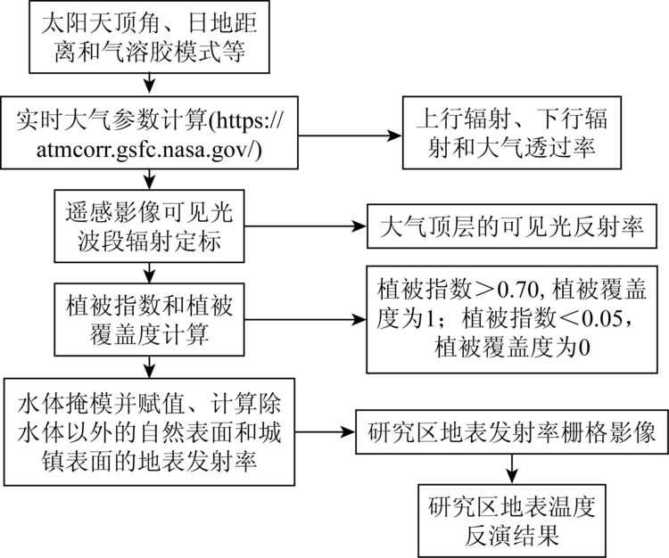
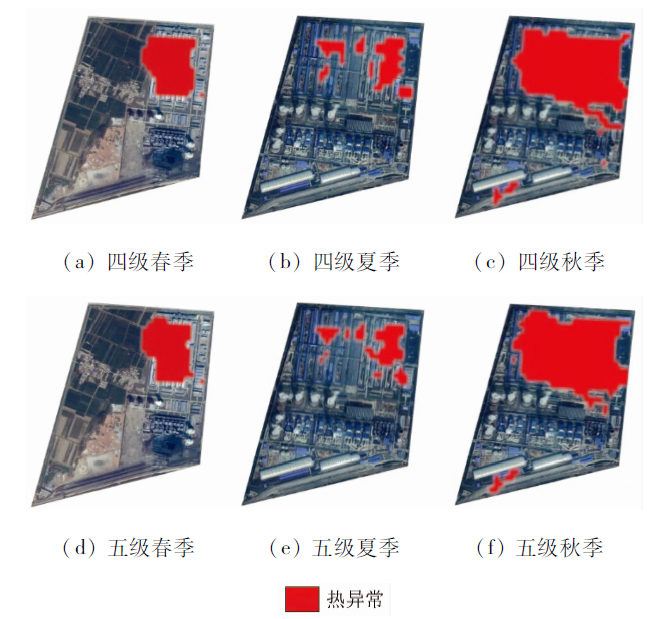
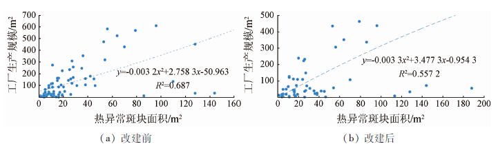
As one of the important mechanisms affecting urban thermal environment, industry accurately detects factories that cause thermal anomalies, and analyzes the impact of industrial thermal anomalies on local thermal environment, which is of great significance for scientific planning of industrial construction and improvement of urban thermal environment. Based on the Landsat8 data of different seasons, this paper uses the radiation transmission method to invert the surface temperature, compares the thermal anomaly detection method based on the thermal field variation index, and performs the local thermal environment effect analysis based on the higher precision detection results. The results are as follows: ① The four-stage method is more suitable for industrial thermal anomaly detection research. ②The scale of the factory production is directly proportional to the area of the corresponding thermal anomaly plaque. For every 5.8 square kilometers of factory production scale, the average thermal plaque area increases by 0.18 square kilometers. ③Industrial thermal anomalies have thermal environmental effects on local building and nonbuilding, the effect of warming on building is smaller with distance, and the effect of temperature increase on nonbuilding in the 1 km range is obvious. The research results can provide reference for industrial thermal anomaly detection and analysis of the effects of industrial thermal anomalies on the local environment.
Xu B, Lin B. How industrialization and urbanization process impacts on CO2 emissions in China:Evidence from nonparametric additive regression models[J]. Energy Economics, 2015,48:188-202.
doi: 10.1016/j.eneco.2015.01.005
[2]
Yan H, Wu F, Dong L. Influence of a large urban park on the local urban thermal environment[J]. Science of the Total Environment, 2018,622-623:882-891.
doi: 10.1016/j.scitotenv.2017.11.327
[3]
Mohan M, Kandya A. Impact of urbanization and land-use/land-cover change on diurnal temperature range:A case study of tropical urban airshed of India using remote sensing data[J]. Science of the Total Environment, 2015,506-507:453-465.
[4]
Robaa S M. Some aspects of the urban climates of Greater Cairo Region,Egypt[J]. International Journal of Climatology, 2013,33(15):3206-3216.
[5]
Rao Y H, Xu Y, Zhang J J, et al. Does subclassified industrial land have a characteristic impact on land surface temperatures? Evidence for and implications of coal and steel processing industries in a Chinese mining city[J]. Ecological Indicators, 2018,89:22-34.
Zhang D H, Wang X P, Kang G F, et al. Study on coal fire area land surface temperature anomaly information extraction from ASTER satellite images:A case study of Yangxia coal fire area in Luntai County,Xinjiang[J]. Coal Geology of China, 2009,21(9):35-37.
Wu X W, Xu Y M, Gong W F. Graphical information characteristics of urban heat island spatial pattern and its change[J]. Geomatics and Information Science of Wuhan University, 2017,42(12):1711-1718.
Chen S L, Wang T X. Comparison analyses of equal interval method and mean-standard deviation method used to delimitate urban heat island[J]. Journal of Geo-Information Science, 2009,11(2):145-150.
Pan J H, Dong L L, Wang N Y, et al. A multi-scale study of thermal environment pattern in Lanzhou Xining agglomeration[J]. Remote Sensing for Land and Resources, 2018,30(2):138-146.doi: 10.6046/gtzyyg.2018.02.19.
Wu W H, Wang X J, Huang R F. Study on urban heat islands Changzhou City based on remote sensing data[J]. Journal of Nanjing Forestry University(Natural Science Edition), 2017,41(5):185-190.
Tao Y X, Xu K F, Yi Z W, et al. A semi-variogram-based analysis of spatial heterogeneity of urban heat islands[J]. Journal of Southwest University(Natural Science), 2018,40(10):145-152.
Sun S M, Lu C Y. Remote sensing monitoring of urban heat island intensity and its application as ecological monitoring index[J]. Journal of Xiamen University(Natural Science), 2002,41(1):66-70.
Luo X B, Chen D, Liu M H, et al. Application research on monitor of heat island effect in Chongqing based on HJ-1B/IRS[J]. Journal of Geo-Information Science, 2011,13(6):833-839.
Zhang Y, Zhao W, Long F, et al. Study of urban heat island based on Landsat TM/TIRS in the central area of Chongqing City[J]. Research of Soil and Water Conservation, 2015,22(5):191-196,203.
Wang H B, Li L G, Zhao Z Q, et al. Urban heat island variation of each district in Shenyang based on TM / ETM+ data[J]. Chinese Journal of Ecology, 2015,34(1):219-226.
[16]
Matthew M, Aaron G, Allen L, et al. Stray light artifacts in imagery from the Landsat8 thermal infrared sensor[J]. Remote Sensing, 2014,6(11):10435-10456.
[17]
Soux A, Voogt J A, Oke T R. A model to calculate what a remote sensor ‘Sees’ of an urban surface[J]. Boundary-Layer Meteoro-logy, 2004,112(2):401-424.
[18]
Yu X, Guo X, Wu Z. Land surface temperature retrieval from Landsat8 TIRS:Comparison between radiative transfer equation-based method,split window algorithm and single channel method[J]. Remote Sensing, 2014,6(10):9829-9852.
[19]
Kamran K V, Pirnazar M, Bansouleh V F. Land surface temperature retrieval from Landsat8 TIRS:Comparison between split window algorithm and SEBAL method[C]// Proceedings of SPIE-the International Society for Optical Engineering, 2015,9535.
[20]
Van D G A A, Owe M. On the relationship between thermal emissivity and the normalized difference vegetation index for natural surfaces[J]. International Journal of Remote Sensing, 1993,14(6):1119-1131.
[21]
Chen J, Yang K, Zhu Y, et al. Analysis of the relationship between land surface temperature and land cover types:A case study of Dianchi Basin[C]// International Conference on Geoinformatics. IEEE, 2016.
Qin Z H, Li W J, Xu B, et al. The estimation of land surface emissivity for Landsat TM6[J]. Remote Sensing for Land and Resources, 2004,16(3):28-32.doi: 10.6046/gtzyyg.2004.03.07.
[23]
Sobrino J A, Jimenez-Muoz J C, Soria G, et al. Land surface emissivity retrieval from different VNIR and TIR sensors[J]. IEEE Transactions on Geoscience and Remote Sensing, 2008,46(2):316-327.
doi: 10.1109/TGRS.36
[24]
Zhang L L, Meng Q, Sun Z H, et al. Spatial and temporal analysis of the mitigating effects of industrial relocation on the surface urban heat island over China[J]. ISPRS International Journal of Geo-Information, 2017,6(4):121.
[25]
马蔼乃. 地理科学与地理信息科学论[M]. 武汉: 武汉出版社, 2000.
Ma A N. Geographical science and geographic information science[M]. Wuhan: Wuhan Publishing House, 2000.
Zhang Y, Yu T, Gu X F, et al. Land surface temperature retrieval from CBERS-02 IRMSS thermal infrared data and its applications in quantitative analysis of urban heat island effect[J]. Journal of Remote Sensing, 2006,10(5):789-797.
doi: 10.11834/jrs.200605117
Xue X J, Meng Q Y, Wang C M, et al. Monitoring spatio-temporal changes of heat island effect in Beijing based on HJ-1B[J]. Journal of Geo-Information Science, 2012,14(4):474-480.
[28]
Zhang L L, Meng Q Y, Sun Z H, et al. Spatial and temporal analysis of the mitigating effects of industrial relocation on the surface urban heat island over China[J]. ISPRS International Journal of Geo-Information, 2017,6(4):121.
Dai Y Y, Liu H, Li Q R, et al. Extraction of built-up land information from medium spatial resolution satellite image[J]. Journal of Subtropical Resources and Environment, 2013,8(4):68-74.
Sun J Q, Liu Y X, Dong Y Z, et al. Classification of urban industrial heat sources based on Suomi-NPP VIIRS nighttime thermal anomaly products:A case study of the Beijing-Tianjin-Hebei Region[J]. Geography and Geo-Information Science, 2018,34(3):13-19.
[31]
Peng S S, Piao S L, Ciais P, et al. Surface urban heat island across 419 global big cities[J]. Environmental Science and Technology, 2011,46(2):696-703.
pmid: 22142232
[32]
Yu Z W, Xu S B, Zhang Y H, et al. Strong contributions of local background climate to the cooling effect of urban green vegetation[J]. Scientific Reports, 2018,8(1):6798.
pmid: 29717184
 2020, Vol. 32
  ), 孟庆岩2(