Deformation monitoring along the landscape corridor of Zhangjiakou Ming Great Wall using Sentinel-1 SBAS-InSAR approach
HE Haiying1,2(), CHEN Caifen3(), CHEN Fulong1, TANG Panpan1
1. Aerospace Information Research Institute, Chinese Academy of Sciences, Beijing 100094, China 2. University of Chinese Academy of Sciences, Beijing 101408, China 3. Beijing Jucai Zhenbang Enterprise Management Consultant Co., Ltd., Beijing 100038, China
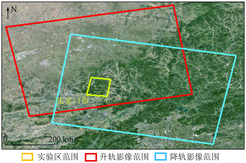
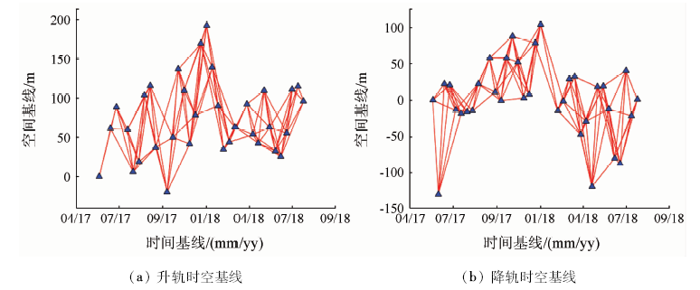
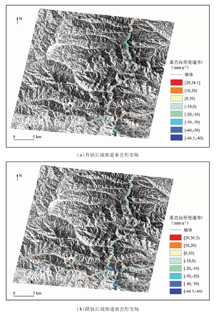
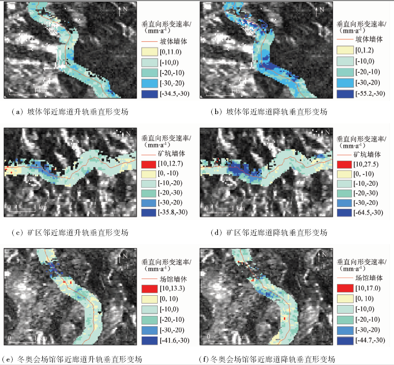
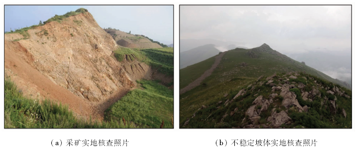
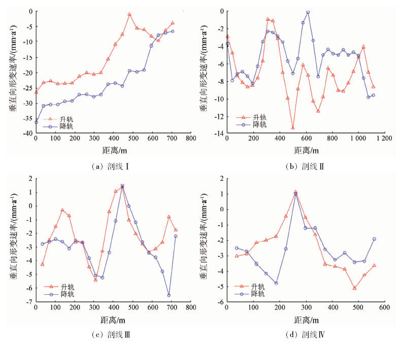
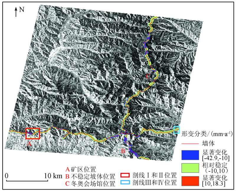
裸露于地表的张家口明长城遗产易受地表形变影响,使得长城沿线景观廊道整体性保护颇具挑战。为了弥补长城大型线性遗产系统形变监测的方法与实践空白,本研究选用SBAS-InSAR方法进行前沿示范。在干涉处理中,为降低大气延迟对干涉图的影响,研究引入GACOS(generic atmospheric correction online service for InSAR)气象数据进行大气校正; 同时试验区地势复杂,研究综合采用40 m Gauss与Goldstein滤波器以降低自然场景噪声相位。实验选取2017年5月—2018年7月升轨33景、降轨34景的Sentinel-1影像进行SBAS-InSAR处理,获取雷达视线向(line of sight,LOS)形变信息并经投影变换获取垂直向形变速率场。为验证结果可靠性,研究分别选择长城景观廊道典型山地区、平地区的升降轨沉降速率场作剖线交叉互检,得到两者数据的均方根误差最大值和平均值分别为9.3 mm/a和4.0 mm/a。考虑显著性水平,以10 mm/a为阈值,结果表明总长度85.1 km的张家口明长城景观廊道中79.5%占比的景观廊道相对稳定,形变速率处于-10~10 mm/a之间; 而剩余20.5%占比的景观廊道则存在显著形变,最大沉降速率为-64.5 mm/a。示范研究揭示了SBAS-InSAR在大型线性遗产宏观形变监测和评估的应用潜力。
The cultural landscape of the Zhangjiakou Ming Great Wall is susceptible to surface deformation, making the systematic conservation of cultural landscape in this corridor quite challenging. In order to fix the methodology and application gaps of Great Wall monitoring (large-scale linear heritage) systematically, the authors applied the SBAS-InSAR technology to the time-series deformation surveillance in this pilot case study. In the procedures of InSAR data processing, an external weather model (GACOS) was firstly used to reduce the atmospheric artifacts on interferograms; moreover, a 40 m Gauss and the Goldstein filters were sequentially applied for the phase noise suppression relevant to the natural landscape. In total 67 Sentinel-1 SAR images including 33 ascending and 34 descending data acquired from May 2017 to July 2018 were collected for the line of sight (LOS) deformation calculation using the SBAS-InSAR approach. The derived deformation rates were then projected onto vertical direction for the further analysis. Afterwards, motion rate profiles of ascending and descending datasets from a typical mountain and a flat area were selected for cross-validation, resulting in the maximum and averaged root mean square errors of 9.3 mm/a and 4.0 mm/a, respectively. With considering the significance level, the result demonstrates that 79.5% of the Great Wall corridor (85.1 km totally observed) is relatively stable (with deformation rates in the range of -10 mm/a to 10 mm/a) while remaining 20.5 % shows significant motions (the maximum subsidence rate up to -64.5 mm/a) using the 10 mm/a as the threshold. This pilot study implied the applicability of the applied SBAS-InSAR approach to the synoptic deformation monitoring of large-scale linear heritage sites.
何海英, 陈彩芬, 陈富龙, 唐攀攀. 张家口明长城景观廊道Sentinel-1影像SBAS形变监测示范研究[J]. 国土资源遥感, 2021, 33(1): 205-213.
HE Haiying, CHEN Caifen, CHEN Fulong, TANG Panpan. Deformation monitoring along the landscape corridor of Zhangjiakou Ming Great Wall using Sentinel-1 SBAS-InSAR approach. Remote Sensing for Land & Resources, 2021, 33(1): 205-213.
Wang X X. Zhangjiakou-Great Wall Museum of Chinese History (China City·Zhangjiakou Special Edition(2))[EB/OL].(2006-09-19)[2018-11-18]. http://paper.people.com.cn/rmrbhwb/html/200609/19/content_11299006.html.
[2]
Gabriel A K, Goldstein R M, Zebker H A. Mapping small elevation changes over large areas-differential Radar interferometry[J]. Journal of Geophysical Research Solid Earth, 1989,94(B7):9183-9191.
Zhu J J, Li Z W, Hu J. Research progress and methods of InSAR for deformation monitoring[J]. Acta Geodaetica et Cartographica Sinica, 2017,46(10):1717-1733.
[4]
Berardino P, Fornaro G, Lanari R, et al. A new algorithm for surface deformation monitoring based on small baseline differential SAR interferograms[J]. IEEE Transactions on Geoscience and Remote Sensing, 2003,40(11):2375-2383.
[5]
Usai S. A least squares database approach for SAR interferometric data[J]. IEEE Transactions on Geoscience and Remote Sensing, 2003,41(4):753-760.
Xu W B, Li Z W, Ding X L, et al. Application of small baseline subsets D-InSAR technology to estimate the time series land deformation and aquifer storage coefficients of Los Angeles area[J]. Chinese Journal of Geophysics, 2012,55(2):452-461.
Zhang Y H, Wu H A, Kang Y H. Ground subsidence over Beijing-Tianjin-Hebei region during three periods of 1992 to 2014 monitored by interferometric SAR[J]. Acta Geodaetica et Cartographica Sinica, 2016,45(9):1050-1058.
Zhou L, Guo J M, Li X, et al. Monitoring and analyzing on ground settlement in Beijing area based on SBAS-InSAR[J]. Journal of Geodesy and Geodynamics, 2016,36(9):793-797.
Sun X P, Lu X Y, Wen X H, et al. Monitoring of ground subsidence in Chengdu Plain using SBAS-InSAR[J]. Remote Sensing for Land and Resources, 2016,28(3):123-129.doi: 10.6046/gtzyyg.2016.03.20.
[10]
吴文豪. 哨兵雷达卫星TOPS模式干涉处理研究[D]. 武汉:武汉大学, 2016.
Wu W H. TOPS interferometry with Sentinel-1[D]. Wuhan:Wuhan University, 2016.
Chen F L, Lin H, Cheng S L. Principles,methods and applications of spaceborne Radar interferometry and time series analysis[M]. Beijing: Science Press, 2013: 41-68.
[12]
胡俊. 基于现代测量平差的InSAR三维形变估计理论与方法[D]. 长沙:中南大学, 2013.
Hu J. Theory and method of estimating three-dimensional displacement with InSAR based on the modern surveying adjustment[D]. Changsha:Central South University, 2013.
[13]
Fialko Y, Simons M, Agnew D. The complete (3-D) surface displacement field in the epicentral area of the 1999 MW7.1 Hector Mine Earthquake,California,from space geodetic observations[J]. Geophysical Research Letters, 2001,28(16):3063-3066.
[14]
Hu J, Li Z W, Zhu J J, et al. Inferring three-dimensional surface displacement field by combining SAR interferometric phase and amplitude information of ascending and descending orbits[J]. Science in China Series D(Earth Sciences), 2010,53(4):550-560.
Zhang X B. Modeling and application of the 2D time series deformation monitoring in urban area using high resolution SAR images[D]. Beijing:China University of Mining and Technology(Beijing), 2018.
Cui X A, Zeng Q M, Tong Q X, et al. Overview of the atmospheric correction methods in repeat-pass InSAR measurements[J]. Remote Sensing Technology and Application, 2014,29(1):9-17.
Sun J L, Yang Z J, Ma J H. Comparison of correction methods of time series InSAR atmospheric delay error based on atmospheric data[J]. Technology Innovation and Application, 2019(11):23-26,30
[18]
Yu C, Penna N T, Li Z. Generation of real-time mode high-resolution water vapor fields from GPS observations[J]. Journal of Geophysical Research(Atmospheres), 2017,122(3):2008-2025.
[19]
Yu C, Li Z, Penna N T. Interferometric synthetic aperture Radar atmospheric correction using a GPS-based iterative tropospheric decomposition model[J]. Remote Sensing of Environment, 2017,204:109-121.
doi: 10.1016/j.rse.2017.10.038
 2021, Vol. 33
  ), 陈彩芬3(