Sentinel-1-based spatial differentiation study of the planting structures in Karst plateau mountainous areas
WANG Yu1,2,3(), ZHOU Zhongfa1,2(), WANG Lingyu1,3, LUO Jiancheng4, HUANG Denghong1,3, ZHANG Wenhui1,2,3
1. School of Geography and Environmental Science/School of Karst Science, Guizhou Normal University, Guiyang 550001, China 2. The State Key Laboratory Incubation Base for Karst Mountain Ecology Environment of Guizhou Province, Guiyang 550001, China 3. State Engineering Technology Institute for Karst Desertification Control, Guiyang 550001, China 4. Aerospace Information Research Institute, Chinese Academy of Sciences, Beijing 100101, China
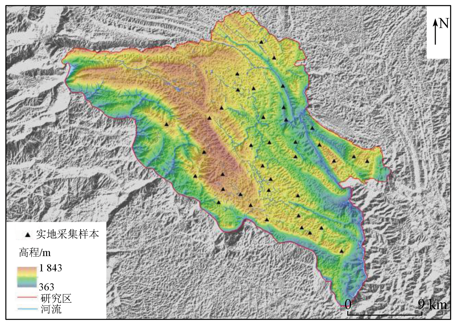
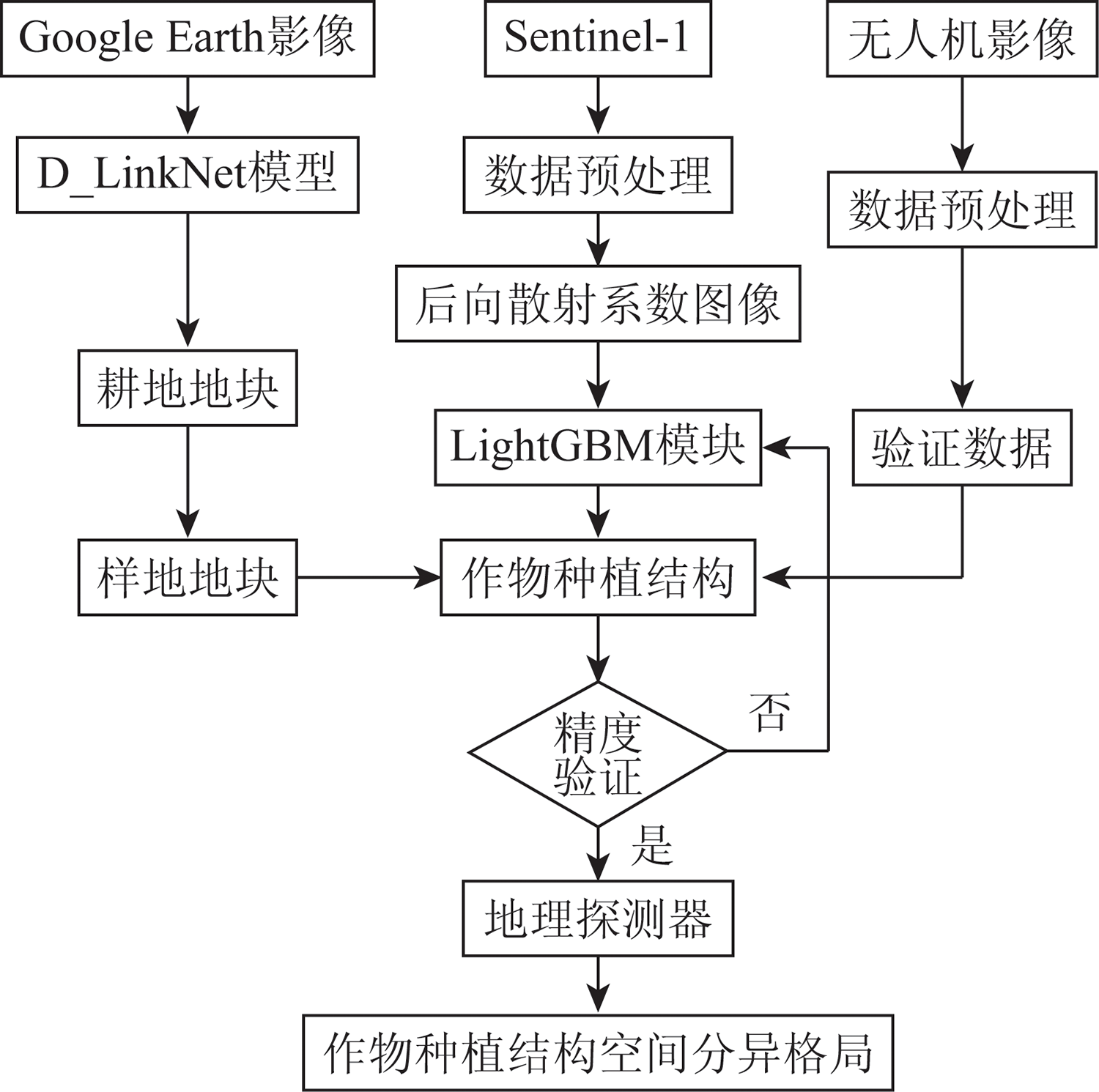
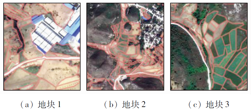
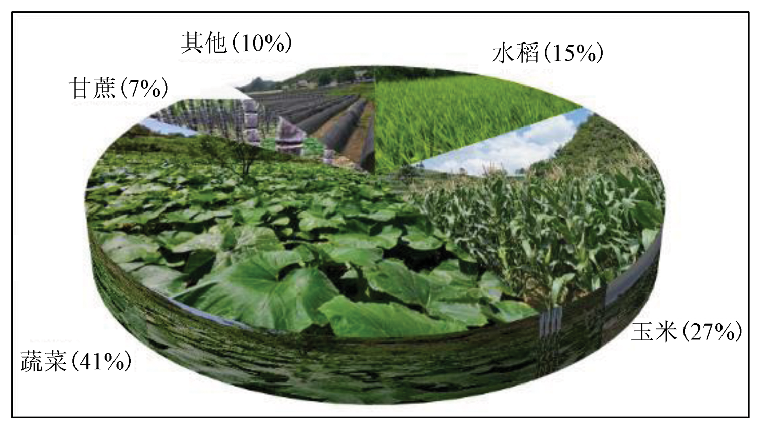
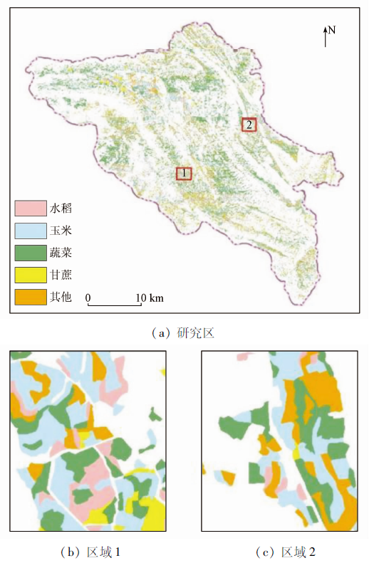
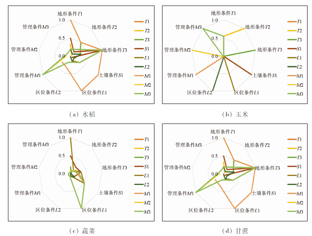
Karst mountainous areas are influenced by complex cloudy and rainy weather. This brings great difficulties to the extraction of planting structure information using the remote sensing technology. Sentinel-1-based crop identification has unique advantages in precision agriculture. It can obtain the information on regional main crops in time and accurately, thus playing a significant role in formulating agricultural policies and guiding agricultural production. This study investigated Guanling County based on Google images in 2020, Sentinel-1 time series data from April to August, and UAV remote sensing data. First, the plots were extracted using the D_LinkNet model. Then, the planting structures were classified based on the LightGBM module. Finally, the spatial differentiation characteristics of main crops and the influencing mechanism of planting structures in the study area were explored combined with geographic detectors. The results are as follows. ① The crops in Guanling County showed an uneven spatial distribution pattern of more crops in the northwest and less crops in the southeast. ② The influence of factor interaction was greater than that of single factors. The distribution of cultivated land was mainly influenced by traffic location and drainage capacity, followed by factors such as elevation and traffic location. ③ The extraction results of crop planting structures are consistent with the proportions shown in the statistical yearbook, with confusion-matrix overall precision of 0.87 and Kappa coefficient of 0.83. The results can help understand the formation mechanisms and differences in the spatial differentiation of different crop planting structures in Karst mountainous areas. Therefore, this study can provide a scientific basis for the optimization and adjustment of planting structures and the analysis of influencing factors.
Tang H Y, Bao P. Change of spatial gravity center of rice planting area and yield in Jiangsu Province based on GIS[J]. Journal of Nanjing Agricultural University(Social Science Edition), 2014, 14(1):118-124.
Yang C Y, Yang G B, Dai L. Guizhou Province cultivated land utilization benefit of time and space differentiationcharacteristics research[J/OL]. Hunan Normal University Journal of Natural Science:1- 10 [2021-12-22]. http://kns.cnki.net/kcms/detail/43.1542.N.20210114.1321.002.html .
Gou Z H, Xu G F, Fan J L. Cultivated land resource use efficiency evaluation in Guizhou and obstacle factor recognition[J]. Journal of Land and Natural Resources Research, 2021(5):24-29.
Yi Q G, Gao Y, Chen H T. Ecological security analysis of cultivated land resources in Karst poor mountainous areas:A case study of Guizhou Province[J]. Rural Economy and Science and Technology, 2021, 32(1):19-20.
[5]
Moran M S, Inoue Y, Barnes E M. Opportunities and limitations for image-based remote sensing in precision crop management[J]. Remote Sensing of Environment, 1997, 61(3):319-346.
doi: 10.1016/S0034-4257(97)00045-X
Zheng C C, Wang X Z, Huang J F. Automatic extraction of rice area information from SPOT-5 satellite imagery based on feature bands[J]. Remote Sensing Technology and Application, 2008, 23(3):294-299.
[7]
Mathur A, Foody G M. Crop classification by support vector machine with intelligently selected training data for an operational application[J]. International Journal of Remote Sensing, 2008, 29(8):2227-2240.
doi: 10.1080/01431160701395203
[8]
Jia K, Wu B, Li Q. Crop classification using HJ satellite multispectral data in the North China Plain[J]. Journal of Applied Remote Sensing, 2013, 7(1):073576.
doi: 10.1117/1.JRS.7.073576
Zhang J K, Cheng Y P, Zheng F W. Extraction of crop planting information based on multi-temporal remote sensing image[J]. Transactions of the Chinese Society of Agricultural Engineering, 2012, 28(2):134-141.
[10]
Foerster S, Kaden K, Foerster M, et al. Crop type mapping using spectral-temporal profiles and phenological information[J]. Computers and Electronics in Agriculture, 2012, 89:30-40.
doi: 10.1016/j.compag.2012.07.015
Li X C, Xu X G, Wang J H, et al. Crop classification and recognition based on time series environmental satellite image[J]. Transactions of the Chinese Society of Agricultural Engineering, 2013, 29(2):169-176.
[12]
Claire B. Monitoring US agriculture:The US department of agriculture,national agricultural statistics service,cropland data layer program[J]. Geocarto International, 2011, 26(5) :341-358.
doi: 10.1080/10106049.2011.562309
[13]
Fiorillo E, Di Giuseppe E, Fontanelli G, et al. Lowland rice mapping in Sédhiou Region(Senegal) using Sentinel 1 and Sentinel 2 data and random forest[J]. Remote Sensing, 2020, 12(20):3403.
doi: 10.3390/rs12203403
[14]
Jiao X, Kovacs J M, Shang J, et al. Object-oriented crop mapping and monitoring using multi-temporal polarimetric RADARSAT-2 data[J]. ISPRS Journal Photogrammetry Remote Sensing, 2014, 96:38-46.
doi: 10.1016/j.isprsjprs.2014.06.014
[15]
Waske B, Schiefer S, Braun M. Random feature selection for decision tree classification of multi-temporal SAR data[C]// Proceedings of the 2006 IEEE International Symposium on Geoscience and Remote Sensing,Denver,CO,USA, 2006:168-171.
Li L, Xu W X. Changes of agricultural eco-efficiency under the effect of rural population aging[J]. Journal of South China Agricultural University(Social Science Edition), 2021, 20(2):14-29.
Guo P, Zhao M, Zhang Y, et al. Optimization adjustment and evaluation of multi-objective planting structure in Hetao irrigation area based on water footprint[J]. Transactions of the Chinese Society for Agricultural Machinery, 2021, 52(12):346-357.
Ye C S, Ma Y T. How human capital and its adaptation to technological progress affect agricultural planting structure[J]. Chinese Rural Economy, 2020(4):34-55.
Liu Q, Xiao H F. Effects of agricultural land management scale and financial policies on agricultural carbon emissions[J]. Resources Science, 2020, 42(6):1063-1073.
Deng Z Y, Wang Q, Zhang Q, et al. Effects of climate warming and drying on grain crops in northern China and countermeasures[J]. Acta Ecologica Sinica, 2010, 30(22):6278-6288.
Zhou H C, Peng H. Multi-objective crop planting structure adjustment and evaluation based on rational utilization of water resources[J]. Transactions of the Chinese Society of Agricultural Engineering, 2007(9):45-49.
Wu X P, Cai D X, Mei X R. Problems and technical countermeasures of agricultural water resources and water environment in The Yellow River Basin[J]. Ecological Environment, 2007(1):248-252.
Guo X J, Zhou R, Li J Z. Problems and technical countermeasures of agricultural water resources and water environment in the Yellow River Basin[J]. Ecological Environment, 2021, 37(3):332-340.
Zhang W, Chen H S, Wang K L. Spatial differentiation characteristics and influencing factors of soil nutrients in Karst peak-depression[J]. Scientia Agricultura Sinica, 2006(9):1828-1835.
[26]
彭建. 喀斯特生态脆弱区土地利用/覆被变化研究[D]. 北京: 北京大学, 2006.
Peng J. Study on land use/cover change in Karst ecologically fragile region[D]. Beijing: Peking University, 2006.
Zhang H Y, Zhao X Y, Cai Y L, et al. Human driving mechanism of land use change in Karst mountainous areas:A case study of Guizhou Province[J]. Geographical Research, 1999(2):25-31.
Yang Y P, Wu Z F, Luo J C. Remote sensing extraction of spatio-temporal synergistic crop distribution at plot scale[J]. Transactions of the Chinese Society of Agricultural Engineering, 2021, 37(7):166-174.
Wu Z F, Luo J C, Sun Y W. Remote sensing research of precision agriculture based on spatio-temporal coordination[J]. Journal of Geo-Information Science, 2020, 22(4):731-742.
[30]
Zhu M, Zhou Z F, Huang D H, et al. Extraction method for single Zanthoxylum bungeanum in Karst mountain area based on UAV visible light images[J]. Journal of Applied Remote Sensing, 2021, 15(2):026501.
[31]
Xia L, Zhang X, Zhang J, et al. Building extraction from very-high-resolution remote sensing images using semi-supervised semantic edge detection[J]. Remote Sensing, 2021, 13(11):2187.
doi: 10.3390/rs13112187
Huang D H, Zhou Z F, Peng R W, et al. Low altitude remote sensing challenge and research progress of crops in mountainous areas of southwest Plateau:A case study of Guizhou Province[J]. Journal of Guizhou Normal University(Natural Science), 2021, 39(5):53-61.
Zhao X, Zhou Z F, Wang L Y. Remote sensing precision extraction and analysis of rocky desertification cultivated land in Karst mountainous areas:A case study of Beipanjiang and Huajiang towns in Guizhou Province[J]. Tropical Geography, 2020, 40(2):289-302.
doi: 10.13284/j.cnki.rddl.003233
[34]
Lu H, Fu X, Liu C, et al. Cultivated land information extraction in UAV imagery based on deep convolutional neural network and transfer learning[J]. Journal of Mountain Science, 2017, 14(4):731-741.
doi: 10.1007/s11629-016-3950-2
[35]
Hu X, Li X. Information extraction of subsided cultivated land in high-groundwater-level coal mines based on unmanned aerial vehicle visible bands[J]. Environmental Earth Sciences, 2019, 78(14):1-11.
doi: 10.1007/s12665-018-7995-0
Cui H Y, Xu S, Zhang L F. Research and prospect of feature selection method in machine learning[J]. Journal of Beijing University of Posts and Telecommunications, 2018, 41(1):1-12.
[37]
Xu Y, Pei J, Lai L. Deep learning based regression and multiclass models for acute oral toxicity prediction with automatic chemical feature extraction[J]. Journal of Chemical Information and Modeling, 2017, 57(11):2672-2685.
doi: 10.1021/acs.jcim.7b00244
pmid: 29019671
[38]
Chen C, Zhang Q, Ma Q, et al. LightGBM-PPI:Predicting protein-protein interactions through LightGBM with multi-information fusion[J]. Chemometrics and Intelligent Laboratory Systems, 2019, 191:54-64.
doi: 10.1016/j.chemolab.2019.06.003
Ma X J, Sha J L, Niu X Q. Design and application of P2P credit rating model based on LightGBM algorithm[J]. Journal of Quantitative and Technical Economics, 2018, 35(5):144-160.
Wang J F, Xu C D. Geographical detectors:Principles and prospects[J]. Acta Geographica Sinica, 2017, 72(1):116-134.
[41]
Wang J F, Li X H, Christakos G, et al. Geographical detectors-based health risk assessment and its application in the neural tube defects study of the Heshun region,China[J]. International Journal of Geographical Information Science, 2010, 24(1):107-127.
doi: 10.1080/13658810802443457
[42]
Liang J, Pan S, Chen W, et al. Cultivated land fragmentation and its influencing factors detection:A case study in Huaihe River Basin,China[J]. International Journal of Environmental Research and Public Health, 2021, 19(1):138.
doi: 10.3390/ijerph19010138
[43]
Wang Z, Liang L, Sun Z, et al. Spatiotemporal differentiation and the factors influencing urbanization and ecological environment synergistic effects within the Beijing-Tianjin-Hebei urban agglomeration[J]. Journal of Environmental Management, 2019, 243:227-239.
doi: S0301-4797(19)30555-9
pmid: 31096175
Guanling Autonomous County Statistics Bureau. Statistical bulletin of national economic and social development in Guanling Autonomous County in 2018[R]. Guanling: Guanling Autonomous County Stastics Bureau, 2018.
 2022, Vol. 34
  ), 周忠发1,2(