Application of mining collapse recognition technology based on multi-source remote sensing
YANG Xianhua1(), WEI Peng2, LYU Jun3, HAN Lei1, SHI Haolin1, LIU Zhi1
1. Sichuan Key Laboratory of Rare Earth Strategic Resources Evaluation and Utilization, Sichuan Geological Survey Institute, Chengdu 610081, China 2. Sichuan Academy of Land and Space Ecological Restoration and Geological Disaster Prevention and Control, Chengdu 610081, China 3. People’s Government of Baodun Town, Chengdu 611438, China
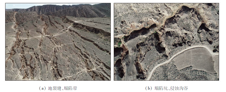
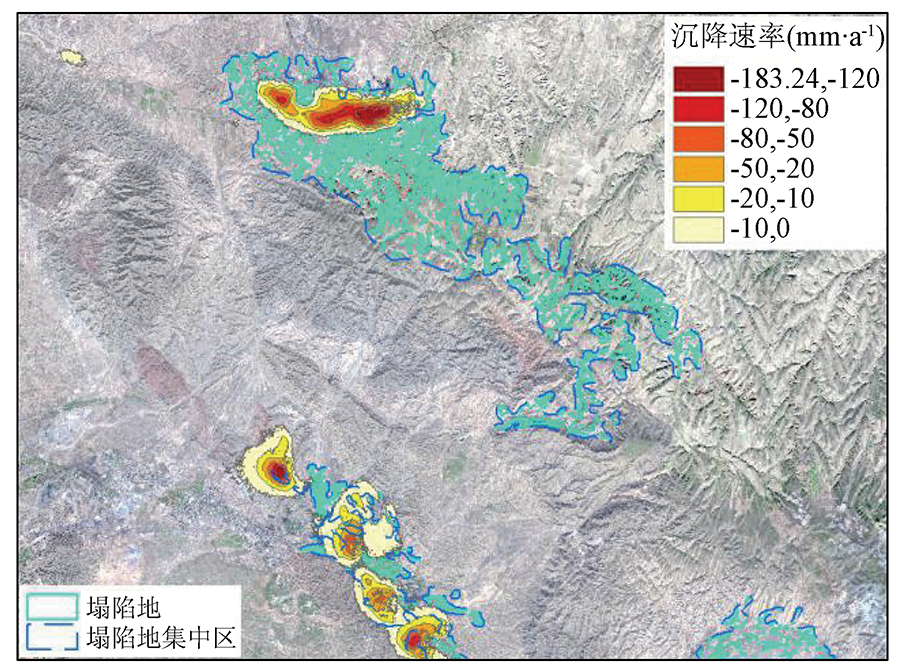
Mining collapse has caused damage to soil, vegetation, and water resources. With the implementation of the national ecological restoration strategy, it is significant to effectively identify and monitor collapse areas. For this purpose, based on multi-source high-resolution remote sensing images and Sentinel-1 SAR radar images, this study identified and monitored the mining collapses of a coal mine in Baiyin City, Gansu Province using the two technologies, namely the Stacking-InSAR method for extracting ground subsidence data and the human-computer interactive interpretation of optical images of mining collapse. Moreover, this study comprehensively compared the characteristics of both techniques and explored the application prospects of both techniques in the deployment of ecological restoration engineering. The results are as follows: ① The Stacking-InSAR radar monitoring technology can better reflect the deformation during the monitoring period and can effectively identify the mining collapse areas in shallow, middle, and deep coal seams. ② The high-resolution optical image technology can better identify the mining collapse areas in shallow and middle coal seams, more accurately identify the damaged land, and can well identify the historically formed mining collapse areas and damaged land whose collapse deformation has stopped. ③ The collapse deformation and land damage of various stages can be obtained by combining the InSAR monitoring technology and the recognition method base on high-resolution remote sensing images, thus providing detailed and reliable basic data for ecological restoration engineering.
Yin Y Q, Yang T Z, Wang J, et al. Remote sensing survey of land occupied and damaged by abandoned mines along the Yangtze River Economic Belt and research on ecological remediation countermeasures[J]. Remote Sensing for Land and Resources, 2020, 32(2):170-176.doi: 10.6046/gtzyyg.2020.02.22.
doi: 10.6046/gtzyyg.2020.02.22
[4]
李建勤. 推进矿业城市绿色发展转型发展[J]. 学习与研究, 2018(3):3.
Li J Q. Promoting the transformation and development of green development of mining cities[J]. Learning and Research, 2018(3):3.
Wang X H, Jing Q Q, Zhou Y J, et al. Remote sensing dynamic monitoring of coal mine subsidence disaster in Shandong Province[J]. Remote Sensing for Land and Resources, 2017, 29(3):203-210.doi: 10.6046/gtzyyg.2017.03.30.
doi: 10.6046/gtzyyg.2017.03.30
Wang H Q, Yang J Z, Chen L, et al. Remote sensing investigation of restoration and management situation in coal mine subsidence areas[J]. Remote Sensing for Land and Resources, 2017, 29(3):156-162.doi: 10.6046/gtzyyg.2017.03.23.
doi: 10.6046/gtzyyg.2017.03.23
Wang J, Liu X Y, Yang J Z, et al. Typical model analysis of mine geological environment restoration and management in Zhejiang Province based on domestic high-resolution satellite data[J]. Remote Sensing for Land and Resources, 2020, 32(3):216-221.doi: 10.6046/gtzyyg.2020.03.28.
doi: 10.6046/gtzyyg.2020.03.28
Yang X H, Huang J, Tian L, et al. Application of mine remote sensing monitoring to analysis of mine goaf stability[J]. Remote Sensing for Land and Resources, 2018, 20(3):143-150.doi: 10.6046/gtzyyg.2018.03.20.
doi: 10.6046/gtzyyg.2018.03.20
Yang X H, Xu X, Xiao L X, et al. Evolution trend and driving force analysis of the Chaerhan Salt Lake[J]. Remote Sensing for Land and Resources, 2020, 32(1):130-137.doi: 10.6046/gtzyyg.2020.01.18.
doi: 10.6046/gtzyyg.2020.01.18
Wu L X, Gao J H, Ge D Q, et al. Experimental study on D-InSAR monitoring of surface subsidence in industrial and mining areas[J]. Journal of Northeast University:Natural Science Edition, 2005, 26 (8):778-782.
Zhang X B, Zhao X S, Ge D Q, et al. Subsidence monitoring of Huainan coal mine from Sentinel TOPS images based on Stacking technique[J]. Remote Sensing for Land and Resources, 2018, 30(4):200-205.doi: 10.6046/gtzyyg.2018.04.30.
doi: 10.6046/gtzyyg.2018.04.30
Liu Y L, Zhang Q, Huang H J, et al. Monitoring and analyzing large scale land subsidence over the mining area using small baseline subset InSAR[J]. Remote Sensing for Land and Resources, 2017, 29(2):144-151.doi: 10.6046/gtzyyg.2017.02.21.
doi: 10.6046/gtzyyg.2017.02.21
Tan Q. Application Research of land subsidence monitoring in mining area based on Sentinel-1A data[J]. Geological and Mineral Mapping, 2019, 35(1):35-38.
Chen L, Yao Z Q, Ma R X, et al. Experimental study on subsidence monitoring of Ningdong coal base using Sentine 1-1A satellite data[J]. Mine Survey, 2017, 45 (3):45-48.
Li X, Tao Q X, Song Y, et al. Sentinel-1A SAR image and its application in land subsidence monitoring in mining area[J]. Surveying and Spatial Geographic Information, 2019, 42(3):31-34,38.
China Geological Survey. DD2011—06 Technical requirements for remote sensing monitoring of mineral resources development[S]. Beijing: China Geological Survey, 2011.
 2022, Vol. 34
  ), 魏鹏2, 吕军3, 韩磊1, 石浩林1, 刘智1