Application and analyses of texture features based on GF-1 WFV images in monthly information extraction of crops
WANG Rong1(), ZHAO Hongli1(), JIANG Yunzhong1, HE Yi2, DUAN Hao1
1. Department of Water Resources, China Institute of Water Resources and Hydropower Research, Beijing 100038, China 2. Faculty of Geomatics, Lanzhou Jiaotong University, Lanzhou 730070, China
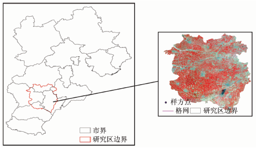
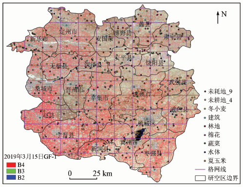
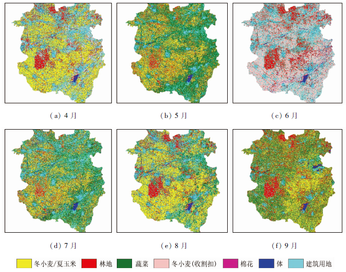
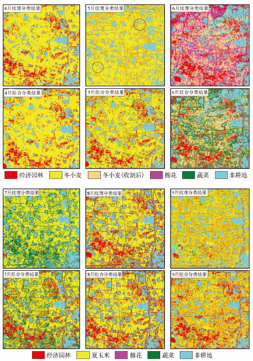
The crop planting structure consists of information such as crop species, quantity structure, and spatial distribution characteristics, and it serves as the basis for agricultural scientific management. Taking the Shijin irrigation area, Hebei Province as the study area and on the premise of not considering the optimal window period of crop time series, this study calculates and analyzes the ability of texture features in crop classification and identification based on GF-1WFV images. Meanwhile, the vegetation index is introduced into the time phase in which the classification effects based on texture features are poor, in order to make up for the defects of texture in the expression of crops. According to the comparison of the classification results of various groups, the classification accuracy of individual texture features reached greater than 80% in April and August when the crop structure is obvious but was still less than 80% in May, June, July, and September when crops are the most complex. After combining the texture features with the vegetation index, the classification results of the crops in these four months were greatly improved. In detail, the overall classification accuracy was greater than 80%, which basically meets the need for agricultural dynamic monitoring. Meanwhile, the accuracy was improved by 2.27%~9.75 % and the Kappa coefficient was increased by 0.02~0.16 compared to the individual texture features. As verified using summer maize samples, the recognition accuracy reached up to 98%, the recognition effects were relatively complete, the fragmentation degree was the minimum, and the optimal discrimination from other crop categories was achieved. Meanwhile, it also proved that the texture features based on GF-1WFV images can be applied to the extraction of the crop planting structure, especially in the months when the crop structure is relatively obvious, and they can provide some effective information for the information extraction of crops base on images.
王镕, 赵红莉, 蒋云钟, 何毅, 段浩. 月尺度农作物提取中GF-1 WFV纹理特征的应用及分析[J]. 自然资源遥感, 2021, 33(3): 72-79.
WANG Rong, ZHAO Hongli, JIANG Yunzhong, HE Yi, DUAN Hao. Application and analyses of texture features based on GF-1 WFV images in monthly information extraction of crops. Remote Sensing for Natural Resources, 2021, 33(3): 72-79.
Yi Z Y, Zhao H L, Jiang Y Z, et al. Daily evapotranspiration estimation at the field scale:Using the modified SEBS model and HJ-1 data in a desert-oasis area,northwestern China[J]. Water, 2018, 10(5):640.
doi: 10.3390/w10050640
Zhang J K, Cheng Y P, Zhang F W. Crop planting information extraction based on multi-temporal remote sensing images[J]. Transactions of the Chinese Society of Agricultural Engineering, 2012, 28(2):134-141.
Ma L, Xu X G, Jia J H, et al. Crop classification method using multi-temporal TM images[J]. Transactions of the Chinese Society of Agricultural Engineering, 2008, 24(s2):191-195.
Xiong Y K, Zhang Q L. Extraction of agricultural planting structure based on NDVI time series images in the economic zone of the northern slope of the Tianshan Mountains[J]. Arid Land Geography, 2019, 42(5):1105-1114.
Pan Y Z, Li L, Zhang J S, et al. Extraction method of crop planting area from MODIS-EVI time series data based on typical phenological characteristics:Experimental study on small area winter wheat[J]. Journal of Remote Sensing, 2011, 15(3):578-594.
Hou X H, Niu Z, Gao S, et al. Vegetation phenology monitoring in the agro-pastoral ecotone based on SPOT-VGT NDVI time series[J]. Transactions of the Chinese Society of Agricultural Engineering, 2013, 29(1):142-150,294.
[8]
Dekker R J. Texture analysis and classification of ERS SAR images for map updating of urban areas in The Netherlands[J]. IEEE Transactions on Geoscience & Remote Sensing, 2003, 41(9):1950-1958.
Zhao L J, Qin Y L, Gao G, et al. High-resolution SAR image building area detection using GLCM texture analysis[J]. Journal of Remote Sensing, 2009, 13(3):483-490.
Huang J X, Hou J Z, et al. Extraction method of corn and soybean planting area based on GF-1 WFV data[J]. Transactions of the Chinese Society of Agricultural Engineering, 2017, 33(7):164-170.
Wang L M, Liu J, Yang F G, et al. Recognizing the area of winter wheat in Beijing-Tianjin-Hebei based on GF-1 remote sensing data[J]. Acta Agronomica Sinica, 2018, 44(5):762-773.
doi: 10.3724/SP.J.1006.2018.00762
Liu G D, Wu M Q, Niu Z, et al. Remote sensing sampling survey method of crop planting area based on GF-1 satellite data[J]. Transactions of the Chinese Society of Agricultural Engineering, 2015, 31(5):160-166.
Ou Y L, Mao D H, Wang Z M, et al. Analysis crops planting structure and yield based on GF-1 and Landsat8 OLI images[J]. Transactions of the Chinese Society of Agricultural Engineering, 2017, 33(11):147-156,316.
Cheng Q, Chen J F. Research on the extraction method of land cover information based on the coastal land on the south coast of Hangzhou Bay of GF-1[J]. Journal of Natural Resources, 2015, 30(2):350-360.
Li H K, Wu J, Wang X L. Object-oriented land use classification of Dongjiang basin based on GF-1 image[J]. Transactions of the Chinese Society of Agricultural Engineering, 2018, 34(10):245-252.
Wang R. Research on the extraction method of crop planting structure based on the integration of spectrum and texture features[D]. Lanzhou:Lanzhou Jiaotong University, 2019.
Quan W T, Wang Z. Research on remote sensing extraction method of winter wheat planting area[J]. Remote Sensing for Land and Resources, 2013, 25(4):8-15.doi: 10.6046/gtzyyg.2013.04.02.
doi: 10.6046/gtzyyg.2013.04.02
Wang L M, Liu J, Yao B M. Monitoring of winter wheat area change based on inter-annual correlation analysis of GF-1 image NDVI[J]. Transactions of the Chinese Society of Agricultural Engineering, 2018, 34(8):184-191.
Yang Y J, Zhan Y L, Tian Q J. Crop classification based on GF-1/WFVNDVI time series data[J]. Transactions of the Chinese Society of Agricultural Engineering, 2015, 31(24):155-161.
[20]
Peleg S. Multiple Resolution Texture Analysis and Classification[J]. IEEE Trans.PAMI, 2009, 6(4):518-523.
Zheng S D, Zheng J H, Shi M H. Remote sensing classification of planted medicinal plants based on fractal and gray-level symbiotic matrix texture features[J]. Journal of Remote Sensing, 2014, 18(4):868-886.
Song R J, Ning J F, Chang Q R. Remote sensing extraction of kiwifruit orchard based on wavelet texture and random forest[J]. Transactions of the Chinese Society of Agricultural Machinery, 2018, 49(4):222-231.
Zhang C, Jin H S, Liu Z. Recognition of seed production corn based on texture analysis of GF remote sensing data[J]. Transactions of the Chinese Society of Agricultural Engineering, 2016, 32(21):183-188.
Wang R, Zhao H L, Hao Z, et al. The monthly-scale dynamic extraction method of crop planting structure for texture feature optimization:China,CN110909652A[P]. 2020-03-24.
Jia K, Li Q Z. Current status and prospects of research on selection of feature variables for crop remote sensing classification[J]. Resources Science, 2013, 35(12):2507-2516.
Wang N, Li Q Z, Du X. Remote sensing identification of main crops in northern Jiangsu based on univariate feature selection[J]. Journal of Remote Sensing, 2017, 21(4):519-530.
Liu X S, Gong Z W, Wu J. Multi-feature-based hyperspectral remote sensing land use information extraction[J]. Journal of Nanjing Forestry University (Natural Science Edition), 2018, 42(4):141-147.
Shan Z B, Kong J L. Research on object-oriented remote sensing survey method of characteristic crop cultivation[J]. Journal of Geo-Information Science, 2018, 20(10):1509-1519.
 2021, Vol. 33
  ), 赵红莉1(