A method for soil roughness measurement based on UAV point cloud data
ZHANG Tian1,2,3(), ZHOU Zhongfa1,2,3(), WANG Lingyu1,2,3, ZHAO Xin1,2,3, ZHANG Wenhui1,2,3, ZHANG Shu1,2,3, WANG Yu1,2,3
1. School of Geography and Environmental Science, Institute of Karst Science, Guizhou Normal University, Guiyang 550001,China 2. State Key Laboratory Incubation Base for Mountain Ecology Environment of Guizhou Province, Guiyang 550001,China 3. State Engineering Technology Institute for Karst Desertification Control, Guiyang 550001, China
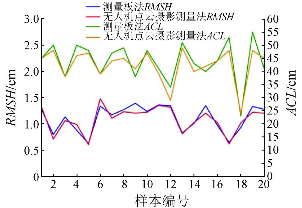
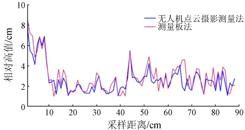
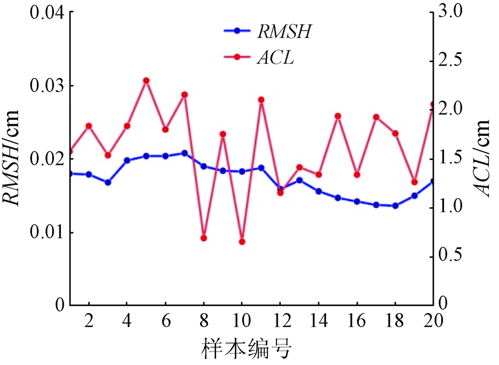
The soil roughness of cultivated land is an important element affecting the monitoring of agricultural information, such as soil moisture, microwave remote sensing observation, and plant growth. Soil roughness is generally interpreted according to field photos. However, such interpretation suffers some shortcomings such as low efficiency and anthropogenic effects on processing results. UAV low-altitude remote sensing is sensitive to surface relief. To explore the precision of the soil roughness determined using UAV data, this study employed UAV photogrammetry to photograph the surface and then compared the photogrammetry results with the data obtained using a gauging plate for soil roughness. The results show that the close-range photogrammetry had mean absolute errors of mainly 0.4~1.2 cm, a mean relative error of 6.16%, and a root mean square error of 0.40 cm. Therefore, UAV-based point cloud photogrammetry could be effectively applied to the measurement of surface roughness, and a smaller sampling area is associated with more accurate soil roughness.
Xu Y L. Roughness retrieval and topographic correction based on bare surface radiative transfer model[D]. Beijing: China University of Geosciences(Beijing), 2009:45-53.
Liang Y, Yang L, Wu Q L, et al. Simulation of soil roughness impact in GNSS-R soil moisture retrieval[J]. Geomatics and Information Science of Wuhan University, 2018, 43(10):1546-1552.
[5]
Alvarez-Mozos J, Verhoest N E, Larranaga A, et al. Influence of surface roughness spatial variability and temporal dynamics on the retrieval of soil moisture from SAR observations[J]. Sensors (Basel), 2009, 9(1):463-489.
doi: 10.3390/s90100463
Chen S C, Lin J H, Sun Y R, et al. Predicting topsoil porosity using soil surface roughness under rainfall influence[J]. Journal of Beijing Forestry University, 2013, 35(2):69-74.
[7]
Darboux F, Gascuelodoux C, Davy P. Effects of surface water storage by soil roughness on overland-flow generation[J]. Earth Surface Processes and Landforms, 2010, 27(3):223-233.
doi: 10.1002/esp.v27:3
[8]
García Moreno R, et al.Díaz Álvarez M C,Saa Requejo A, Multifractal analysis of soil surface roughness[J]. Vadose Zone Journal, 2008, 7(2):512-520.
doi: 10.2136/vzj2007.0016
[9]
Thomsen L M, Baartman J E M, Barneveld R J, et al. Soil surface roughness:Comparing old and new measuring methods and application in a soil erosion model[J]. Soil, 2015, 1(1):399-400.
doi: 10.5194/soil-1-399-2015
[10]
Riegler-Nurscher P, Moitzi G, Prankl J, et al. Machine vision for soil roughness measurement and control of tillage machines during seedbed preparation[J]. Soil and Tillage Research, 2020, 196:104351.
doi: 10.1016/j.still.2019.104351
[11]
Robichaud P R, Molnau M. Measuring soil roughness changes with an ultrasonic profiler[J]. Transactions of the ASAE, 1990, 33(6):1851-1858.
doi: 10.13031/2013.31549
Tao H R, Chen Q, Li Z, et al. Improvement of soil surface roughness measurement accuracy by close-range photogrammetry[J]. Transactions of the Chinese Society of Agricultural Engineering, 2017, 33(15):162-167.
Cai X, Sun Y R, Lin J H, et al. Design of a laser scanner for characterizing soil surface roughness[J]. Transactions of the Chinese Society for Agricultural Machinery, 2010, 41(1):68-69.
Wang Z Q, Bai J L, Zhang M. Application of digital photogrammetry and 3D modeling in teaching of rock discontinuity surface roughness[J]. Experimental Technology and Management, 2020, 37(3):45-47.
Wang H X, Zhang G H, Zhu P Z, et al. Comparison of three metho-ds to measure surface random roughness[J]. Journal of Soil and Water Conservation, 2020, 27(4):72-76.
Zhang S B, Huang P K, Zhao Z X. A research on soil surface roughness measurement methods[J]. Journal of Agricultural Mechanization Research, 2016, 38(11):257-262.
[17]
李红阳. 基于无人机摄影测量技术的土地调查方法研究[D]. 唐山: 华北理工大学, 2018.
Li H Y. The research method of land survey based on UAV photogrammetry techology[D]. Tangshan: North China University of Science and Technology, 2018.
Li D R, Li M. Research progress and application prospect of UAV remote sensing system[J]. Geomatics and Information Science of Wuhan University, 2014, 39(5):505-512.
[19]
Warner W S. Mapping a three-dimensional soil surface with hand-held 35 mm photography[J]. Soil and Tillage Research, 1995, 34(3):187-197.
doi: 10.1016/0167-1987(95)00462-2
Xu Y H. The application of low-altitude drone thchnology in the production of large scale DLG in Guizhou mountain area[D]. Guiyang: Guizhou Normal University, 2018:1-8.
Hu Y X, Zhang H D, Xiong W H, et al. Survey and engineering application of metro completion plan acceptance based on 3D laser point cloud[J]. Bulletin of Surveying and Mapping, 2020(s1):53-58.
Yin L J, Zhou Z F, Li S H, et al. Research on vegetation extraction and fractional vegetation cover of Karst area based on visible light image of UAV[J]. Acta Agrestia Sinica, 2020, 28(6):1664-1672.
Feng J J. Single tree parameter extraction based on LiDAR point cloud data and high resolution image[D]. Beijing: Beijing Forestry University, 2017:1-5.
Zhao X, Yue C R, Li C G, et al. Canopy density estimation based on airborne LiDAR point cloud data[J]. Remote Sensing Technolo-gy and Application, 2020, 35(5):1136-1145.
Jiang Y, Wang J, Chen F Y. Extraction of paddy planting area based on LiDAR point cloud data at field-scale in black soil area[J]. Engineering of Surveying and Mapping, 2020, 29(4):32-37.
Duan P, Li J, Li H K, et al. 3D modeling method of UAV image point cloud matching with ground laser point cloud[J]. Engineering of Surveying and Mapping, 2020, 29(4):44-47.
Liu J, Yang X J, Liao Y T, et al. Study on soil surface roughness measurement method based on linear laser sensor[J]. Transactions of the Chinese Society of Agricultural Engineering, 2019, 35(3):134-138.
Luo D, Lin H S, Jin Z, et al. Application and comparison of UAV digital photogrammetry and LiDAR in topography and land cover research[J]. Journal of Earth Environment, 2018, 10(3):215-222.
[29]
Verhoeven G. Taking computer vision aloft-archaeological three-dimensional reconstructions from aerial photographs with PhotoScan[J]. Archaeological Prospection, 2011, 18(1):67-73.
doi: 10.1002/arp.v18.1
[30]
Remondino F, El-Hakim S. Image-based 3D modelling:A review[J]. Photogrammetric Record, 2010, 21(115):269-291.
doi: 10.1111/(ISSN)1477-9730
[31]
Tavani S, Granado P, Corradetti A, et al. Building a virtual outcrop,extracting geological information from it,and sharing the results in Google Earth via OpenPlot and Photoscan:An example from the Khaviz Anticline (Iran)[J]. Computers and Geosciences, 2014, 63:44-53.
doi: 10.1016/j.cageo.2013.10.013
Cai Z W, Kang J, Wang L, et al. Construction of mountain plantation landscape DEM based on UAV image[J]. Remote Sensing Technology and Application, 2015, 30(3):504-509.
Xing M F, Huang F, Guan Y W. Experimental study on measurement of soil surface roughness based on image processing[J]. Experiment Science and Technology, 2019, 17(6):1-3.
Liu L C, Wei G L, Zhang Q S, et al. Design and experiment of agricultural microgeomorphology measuring device based on LiDAR[J]. Transactions of the Chinese Society for Agricultural Machinery, 2019, 50(7):85-91.
Lei Z B. Research on soil moisture retrieval of crop covering area based on GaoFen3 Radar data[D]. Beijing: China University of Geosciences(Beijing), 2020:18-20.
Li L, Wang D, Pan C X, et al. Soil surface roughness measuring method based on neural network and decision tree[J]. Transactions of the Chinese Society of Agricultural Engineering, 2015, 31(14):132-138.
Zhang H R, Duan X M, Wei Z, et al. LAI monitoring of summer maize in North China based on UAV multi-spectral remote sensing[J]. Journal of Shanxi Agricultural Sciences, 2021, 49(5):608-614.
Zheng X M, Zhao K, Li X J. Accuracy analysis of agriculture soil surface roughness parameter[J]. Journal of Geo-Information Science, 2013, 15(5):753-755.
[39]
Kim S B, Moghaddam M, Tsang L, et al. Models of L-band Radar backscattering coefficients over global rain for soil moisture retrieval[J]. IEEE Transactions on Geoscience and Remote Sensing, 2014, 52(2):1381-1396.
doi: 10.1109/TGRS.2013.2250980
 2023, Vol. 35
  ), 周忠发1,2,3(