An information extraction model of roads from high-resolution remote sensing images based on improved Deeplabv3+
ZHAO Linghu1(), YUAN Xiping2,3, GAN Shu1,2(), HU Lin1, QIU Mingyu1
1. School of Land and Resources Engineering, Kunming University of Science and Technology, Kunming 650093, China 2. Surveying and Mapping Geo-Informatics Technology Research Center on Plateau Mountains of Yunnan Higher Education, Kunming 650093, China 3. School of Earth Science and Engineering, West Yunnan University of Applied Sciences, Dali 671000, China
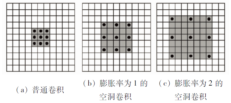
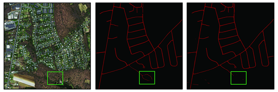
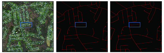
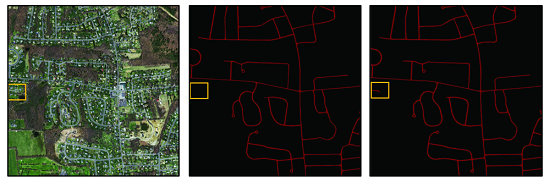
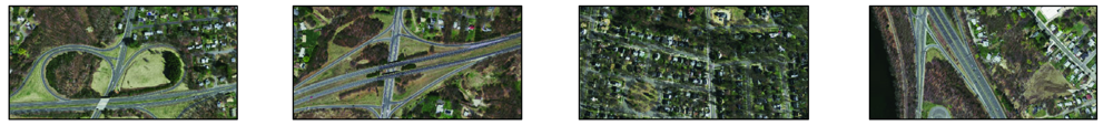
Aiming at the problems of poor extraction effect and slow extraction speed of traditional road extraction methods in the information extraction of roads from high-resolution remote sensing images, this study proposed a new information extraction model based on improved Deeplabv3+. In the new model, the combination of the MobileNetv2 backbone feature extraction network with the Dice Loss function effectively balanced the contradiction between the precision and speed of road information extraction from high-resolution remote sensing images. As a result, high extraction precision was achieved while meeting timeliness requirements by reducing model parameters. The experimental results based on the open-source road information extraction dataset show that: ① The road information extraction model proposed in this study was feasible for high-resolution remote sensing images, with overall accuracy of up to 98.71%; ② In terms of the information extraction speed, the new model had an average frame number of 120.05 and parameter amount of only 5.81 M. Therefore, the new model was more lightweight lighter than original models, meeting the timeliness requirements. Therefore, the model proposed in this study meets the timeliness requirements by greatly reducing the parameter amount while ensuring high extraction accuracy. This study provides a new philosophy and method for improving the accuracy and speed of road information extraction from high-resolution images.
赵凌虎, 袁希平, 甘淑, 胡琳, 丘鸣语. 改进Deeplabv3+的高分辨率遥感影像道路提取模型[J]. 自然资源遥感, 2023, 35(1): 107-114.
ZHAO Linghu, YUAN Xiping, GAN Shu, HU Lin, QIU Mingyu. An information extraction model of roads from high-resolution remote sensing images based on improved Deeplabv3+. Remote Sensing for Natural Resources, 2023, 35(1): 107-114.
Herold M, Roberts D. Spectral characteristics of asphalt road aging and deterioration:Implications for remote-sensing applications[J]. Applied Optics, 2005, 44(20):4327-4334.
doi: 10.1364/AO.44.004327
[2]
Kass M, Witkin A, Terzopoulos D. Snakes:Active contour models[J]. International Journal of Computer Vision, 1988, 1(4):321-331.
doi: 10.1007/BF00133570
Luo Q Z, Yin Q, Kuang D B. Research on extracting road based on its spectral feature and shape feature[J]. Remote Sensing Technolo-gy and Application, 2007, 22(3):339-344.
[4]
Ghaziani M, Mohamadi Y, Koku A B, et al. Extraction of unstructured roads from satellite images using binary image segmentation[C]// 2013 21st Signal Processing and Communications Applications Conference (SIU).IEEE, 2013:1-4.
[5]
Sirmaçek B, Ünsalan C. Road network extraction using edge detection and spatial voting[C]// 2010 20th International Conference on Pattern Recognition.IEEE, 2010:3113-3116.
Jia J X, Sun H B, Jiang C H, et al. Road extraction technology based on multi-source remote sensing data: Review and prospects[J]. Optics and Precision Engineering, 2021, 29(2):430-442.
doi: 10.37188/OPE.20212902.0430
[7]
Krizhevsky A, Sutskever I, Hinton G E. ImageNet classification with deep convolutional neural networks[J]. Communications of the ACM, 2017, 60(6):84-90.
doi: 10.1145/3065386
[8]
He K M, Zhang X Y, Ren S Q, et al. Deep residual learning for image recognition[C]// 2016 IEEE Conference on Computer Vision and Pattern Recognition.IEEE, 2016:770-778.
[9]
Mnih V, Hinton G E. Learning to detect roads in high-resolution aerial images[C]// European Conference on Computer Vision.Springer,Berlin,Heidelberg, 2010:210-223.
[10]
叶雪娜. 基于卷积神经网络的遥感图像道路提取研究[D]. 西安: 陕西师范大学, 2017.
Ye X N. Research on remote sensing image road extraction based on convolutional neural network[D]. Xi’an: Shaanxi Normal University, 2017.
[11]
Long J, Shelhamer E, Darrell T. Fully convolutional networks for semantic segmentation[C]// Proceedings of the 2015 IEEE Conference on Computer Vision and Pattern Recognition.Washington, DC: IEEE Computer Society, 2015:3431-3440.
[12]
Chen L C, Papandreou G, Kokkinos I, et al. Semantic image segmentation with deep convolutional nets and fully connected CRFs[J]. Computer Science, 2014(4):357-361.
[13]
Chen L C, Zhu Y, Papandreou G, et al. Encoder-decoder with atrous separable convolution for semantic image segmentation[C]// Proceedings of the European Conference on Computer Vision, 2018:801-818.
Wei Y C, Zhao Y. A review on image semantic segmentation based on DCNN[J]. Journal of Beijing Jiaotong University, 2016, 40(4):82-91.
[15]
Sandler M, Howard A, Zhu M, et al. Mobilenetv2:Inverted residuals and linear bottlenecks[C]// Proceedings of the IEEE Conference on Computer Vision and Pattern Recognition, 2018:4510-4520.
[16]
Mnih V. Machine learning for aerial image labeling[D]. Toronto: University of Toronto, 2013.
 2023, Vol. 35
  ), 袁希平2,3, 甘淑1,2(