Current status of the acquisition and processing of airborne laser sounding data
CUI Ziwei1,2(), XU Wenxue2(), LIU Yanxiong2, GUO Yadong2, MENG Xiangqian1, JIANG Zhengkun2
1. College of Ocean Science and Engineering, Shandong University of Science and Technology, Qingdao 266590, China 2. First Institute of Oceanography, Ministry of Natural Resources, Qingdao 266061, China
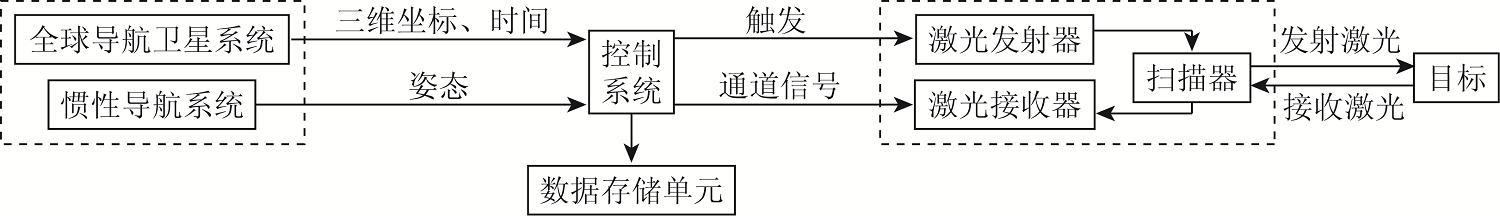
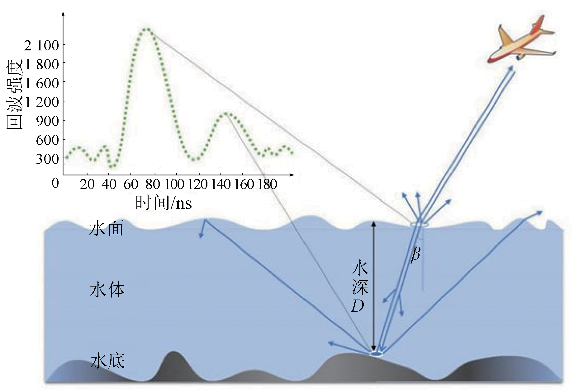
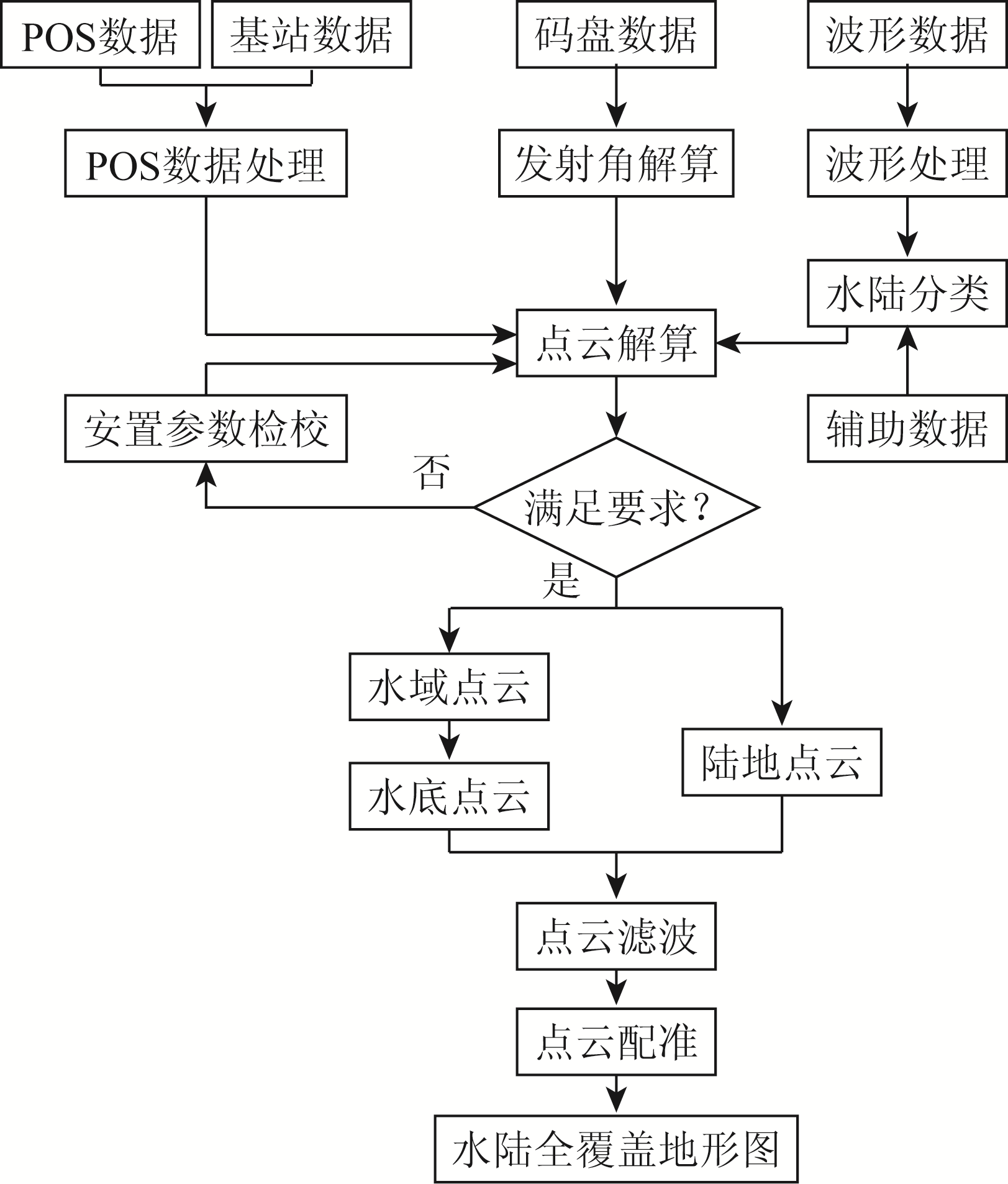
As an essential branch of surveying and mapping science, underwater topographic surveys are closely related to human operations in oceans and lakes. For underwater topography detection in shallow-water areas, conventional acoustic methods face the hull stranding risk, and passive optical methods have low survey accuracy. The airborne laser sounding is a novel means for bathymetric surveys in shallow-water areas, and its application in offshore areas can fill the gap of underwater topography data in shallow-water areas. This study presents a brief introduction to the composition and principle of the airborne laser sounding system, followed by a description of laser sounding data acquisition. Furthermore, this study highlights the critical processing technologies for airborne laser sounding data, including waveform data processing, error correction, and point cloud data processing. Finally, this study summarizes the technical difficulties and developmental trends of airborne laser sounding.
崔子伟, 徐文学, 刘焱雄, 郭亚栋, 孟祥谦, 蒋正坤. 机载激光测深数据获取及处理技术现状[J]. 自然资源遥感, 2023, 35(3): 1-9.
CUI Ziwei, XU Wenxue, LIU Yanxiong, GUO Yadong, MENG Xiangqian, JIANG Zhengkun. Current status of the acquisition and processing of airborne laser sounding data. Remote Sensing for Natural Resources, 2023, 35(3): 1-9.
Ma Y, Zhang J, Zhang J Y, et al. Progress in shallow water depth mapping from optical remote sensing[J]. Advances in Marine Science, 2018, 36(3):331-351.
[5]
Wright A E, Conlin D L, Shope S M. Assessing the accuracy of underwater photogrammetry for archaeology:A comparison of structure from motion photogrammetry and real time kinematic survey at the east key construction wreck[J]. Journal of Marine Science and Engineering, 2020, 8(11):849.
doi: 10.3390/jmse8110849
[6]
Muirhead K, Cracknell A P. Airborne LiDAR bathymetry[J]. International Journal of Remote Sensing, 1986, 7(5):597-614.
doi: 10.1080/01431168608954714
Qin H M, Wang C, Xi X H, et al. Development of airborne laser bathymetric technology and applications[J]. Remote Sensing Technology and Application, 2016, 31(4):617-624.
Liu Y X, Guo K, He X F, et al. Research progress of airborne laser bathymetry technology[J]. Geomatics and Information Science of Wuhan University, 2017, 42(9):1185-1194.
Li Q, Wang J C, Han Y C, et al. Potential evaluation of China’s coastal airborne LiDAR bathymetry based on CZMIL Nova[J]. Remote Sensing for Land and Resources, 2020, 32(1):184-190.doi:10.6046/gtzyyg.2020.01.25.
doi: 10.6046/gtzyyg.2020.01.25
State Administration for Market Regulation, Standardization Administration. GB/T 39624—2020 Technical specification for underwater topographic survey of airborne LiDAR[S]. Beijing: China Standards Publishing House, 2020.
[13]
王丹菂. 机载激光测深回波信号探测技术研究[D]. 郑州: 战略支援部队信息工程大学, 2018.
Wang D D. Research on signal detection for airborne LiDAR bathymetry[D]. Zhengzhou: PLA Strategic Support Force Information Engineering University, 2018.
Xu G X, Zhai G J, Wu T Q, et al. The key technical issues on airborne LiDAR bathymetry operation[J]. Hydrographic Surveying and Charting, 2019, 39(2):45-49.
Ye X S. Research on principle and date processing methods of airborne laser bathymetric technique[D]. Zhengzhou: PLA Strategic Support Force Information Engineering University, 2010.
Wu F, Jin D J, Zhang Z G, et al. A preliminary study on land-sea integrated topographic surveying based on CZMIL bathymetric technique[J]. Remote Sensing for Natural Resources, 2021, 33(4):173-180.doi:10.6046/zrzyyg.2021.10.07.
doi: 10.6046/zrzyyg.2021.10.07
Zeng K, Xu Z T, Yang Y Z, et al. Design and application of reflectance measurement system for sea bottom in optically shallow water[J]. Spectroscopy and Spectral Analysis, 2020, 40(2):579-585.
Jin D J, Wu F, Yu K, et al. Large-scale application test and evaluation of an airborne LiDAR bathymetry system:A case study in China’s coastal zone[J]. Infrared and Laser Engineering, 2020, 49(s2):9-23.
Li D, Wang C, Xi X H, et al. An automatic bore-sight calibration method for airborne LiDAR based on co-planar constrains[J]. Science of Surveying and Mapping, 2017, 42(9):98-103.
[24]
王延存. 机载激光雷达全波形数据处理研究[D]. 青岛: 山东科技大学, 2019.
Wang Y C. Research on full-waveform data processing of airborne LiDAR system[D]. Qingdao: Shandong University of Science and Technology, 2019.
[25]
Jutzi B, Stilla U. Range Determination with waveform recording laser systems using a Wiener filter[J]. ISPRS Journal of Photogra-mmetry and Remote Sensing, 2006, 61(2):95-107.
[26]
Biggs D S C, Anderws M. Acceleration of iterative image restoration algorithms[J]. Applied Optics, 1997, 36(8):1766-1775.
pmid: 18250863
[27]
Lawson C L, Hanson R J. Solving least squares problems[M]. Englewood Cliffs,NJ: Prentice-Hall, 1974:50-60.
[28]
Wagner W, Roncat A, Melzer T, et al. Waveform analysis techniques in airborne laser scanning[C]// International Archives of Photogrammetry and Remote Sensing, 2007, 36(3):413-418.
Yao C H, Chen W B, Zang H G, et al. Study of the capability of minimum depth using an airborne laser bathymetry[J]. Acta Optica Sinica, 2004(10):1406-1410.
[30]
Wong H, Antoniou A. Characterization and decomposition of waveforms for laser 500 airborne system[J]. IEEE Transactions on Geo-science and Remote Sensing, 1991, 29 (6):912-921.
doi: 10.1109/36.101370
[31]
Abdallah H, Bailly J S, Baghdadi N N, et al. Potential of space-borne LiDAR sensors for global bathymetry in coastal and inland waters[J]. IEEE Journal of Selected Topics in Applied Earth Observations and Remote Sensing, 2013, 6(1):202-216.
doi: 10.1109/JSTARS.4609443
Li K, Zhang Y S, Tong X C, et al. The impact of different fitting functions for water backscatter waveforms on the accuracy of laser sounding[J]. Geomatics and Information Science of Wuhan University, 2018, 43(4):548-554.
[33]
丁凯. 单波段机载测深激光雷达全波形数据处理算法及应用研究[D]. 深圳: 深圳大学, 2018.
Ding K. Airborne LiDAR bathymetry full waveform data processing methods and application study[D]. Shenzhen: Shenzhen University, 2018.
Guo K, Liu Y X, Xu W X, et al. Comparison of LM and EM parameter optimization methods for airborne laser bathymetric full-waveform decomposition[J]. Acta Geodaetica et Cartographica Sinica, 2020, 49(1):117-131.
doi: 10.11947/j.AGCS.2020.20180242
[35]
Shen X, Li Q, Wu G, et al. Decomposition of LiDAR waveforms by B-spline-based modeling[J]. ISPRS Journal of Photogrammetry and Remote Sensing, 2017, 128(3):182-191.
doi: 10.1016/j.isprsjprs.2017.03.006
Wang D D, Xu Q, Xing S, et al. A coarse-to-fine signal detection method for airborne LiDAR bathymetry[J]. Acta Geodaetica et Cartographica Sinica, 2018, 47(8):1148-1159.
doi: 10.11947/j.AGCS.2018.20170466
Qi C, Su D P, Wang X K, et al. Fitting algorithm for airborne laser bathymetric waveforms based on layered heterogeneous model[J]. Infrared and Laser Engineering, 2019, 48(2):114-121.
[38]
Roland S, Gottfried M, Martin P, et al. Design and evaluation of a full-wave surface and bottom-detection algorithm for LiDAR bathymetry of very shallow waters[J]. ISPRS Journal of Photogrammetry and Remote Sensing, 2019, 150:1-10.
doi: 10.1016/j.isprsjprs.2019.02.002
[39]
Yang F, Qi C, Su D, et al. An airborne LiDAR bathymetric waveform decomposition method in very shallow water:A case study around Yuanzhi Island in the South China Sea[J]. International Journal of Applied Earth Observation and Geoinformation, 2022, 109:102788.
doi: 10.1016/j.jag.2022.102788
[40]
Guenther G C, Larocque P E, Lillycropj W. Multiple surface channels in scanning hydrographic operational airborne LiDAR survey (SHOALS) airborne LiDAR[C]//Proceedings of 1994 International Society for Optical Engineering. Bergen,Norway: SPIE, 1994:422-431.
Wang D D, Xing S, Xu Q, et al. Automatic sea-land waveform classification method for single-wavelength airborne LiDAR bathymetry[J]. Acta Geodaetica et Cartographica Sinica, 2022, 51(5):750-761.
doi: 10.11947/j.AGCS.2022.20200314
[42]
Ji X, Tang Q, Xu W, et al. Island feature classification for single-wavelength airborne LiDAR bathymetry based on full-waveform parameters[J]. Applied Optics, 2021, 60(11):3055-3061.
doi: 10.1364/AO.420673
Hu S J, He Y, Tao B Y, et al. Classification of sea and land waveforms based on deep learning for airborne laser bathymetry[J]. Infrared and Laser Engineering, 2019, 48(11):165-172.
[44]
Fernandez-Diaz J C, Glennie C L, Carter W E, et al. Early results of simultaneous terrain and shallow water bathymetry mapping using a single-wavelength airborne LiDAR sensor[J]. IEEE Journal of Selected Topics in Applied Earth Observations and Remote Sensing, 2013, 7(2):623-635.
doi: 10.1109/JSTARS.4609443
[45]
Smeeckaert J, Clément M, David N. Classification of water surfaces using airborne topographic LiDAR data[C]// International Archives of Photogrammetry,Remote Sensing and Spatial Information Sciences (IAPRS), 2013, XL-1/W1:321-326.
[46]
王晓阳. 基于机载激光测深波形和点云数据的水陆分类研究[D]. 泰安: 山东农业大学, 2021.
Wang X Y. Water-land classification based on waveform and point cloud data of airborne LiDAR bathymetry[D]. Taian: Shandong Agricultural University, 2021.
Wang X, Pan H Z, Luo S, et al. Bathymetric technology and research status of airborne LiDAR[J]. Hydrographic Surveying Charting, 2019, 39(5):78-82.
[48]
Su D, Yang F, Ma Y, et al. Propagated uncertainty models arising from device,environment,and target for a small laser spot airborne LiDAR bathymetry and its verification in the South China Sea[J]. IEEE Transactions on Geoscience and Remote Sensing, 2020, 58(5):3213-3231.
doi: 10.1109/TGRS.36
[49]
Patrick W, Hans-Gerd M, Katja R, et al. Analysis and correction of ocean wave pattern induced systematic coordinate errors in airborne LiDAR bathymetry[J]. ISPRS Journal of Photogrammetry and Remote Sensing, 2017, 128:314-325.
doi: 10.1016/j.isprsjprs.2017.04.008
Zhao J H, Wu J W, Zhao X L, et al. A correction model for depth bias in airborne LiDAR bathymetry systems[J]. Geomatics and Information Science of Wuhan University, 2019, 44(3):328-333.
Ye X S, Zhang C D, Wang A B, et al. Analysis of the airborne laser scanning bathymetry errors[J]. Journal of Geomatics Science and Technology, 2008, 25(6):400-402.
[52]
Yang F, Su D, Ma Y, et al. Refraction correction of airborne LiDAR bathymetry based on sea surface profile and ray tracing[J]. IEEE Transactions on Geoscience and Remote Sensing, 2017, 55(11):6141-6149.
doi: 10.1109/TGRS.2017.2721442
[53]
Xu W, Guo K, Liu Y, et al. Refraction error correction of airborne LiDAR bathymetry data considering sea surface waves[J]. International Journal of Applied Earth Observation and Geoinformation, 2021, 102:102402.
doi: 10.1016/j.jag.2021.102402
Yang A X. A point cloud thinning method of airborne LiDAR based on mutivariate terrain features[D]. Qingdao: Shandong University of Science and Technology, 2018.
[55]
Zhang W, Qi J, Wan P, et al. An easy-to-use airborne LiDAR data filtering method based on cloth simulation[J]. Remote Sensing, 2016, 8(6):501.
doi: 10.3390/rs8060501
[56]
Yang A, Wu Z, Yang F, et al. Filtering of airborne LiDAR bathymetry based on bidirectional cloth simulation[J]. ISPRS Journal of Photogrammetry and Remote Sensing, 2020, 163:49-61.
doi: 10.1016/j.isprsjprs.2020.03.004
Zhang F, Xu W X, Tang L, et al. Comparison of airborne LiDAR bathymetry data refistration methods[J]. Journal of Nanjing University of Information Science and Technology(Natural Science Edition), 2021, 13(6):678-685.
[58]
Yang F, Su D, Zhang K, et al. Mosaicing of airborne LiDAR bathymetry strips based on Monte Carlo matching[J]. Marine Geophysical Research, 2017, 38(3):303-311.
doi: 10.1007/s11001-017-9309-4
[59]
Wang X, Yang F, Zhang H, et al. Registration of airborne LiDAR bathymetry and multibeam echo sounder point clouds[J]. IEEE Geoscience and Remote Sensing Letters, 2021, 20(3):1-5.
[60]
Ji X, Yang B, Tang Q, et al. A coarse-to-fine strip mosaicing model for airborne bathymetric LiDAR data[J]. IEEE Transactions on Geoscience and Remote Sensing, 2021, 59(10):8129-8142.
doi: 10.1109/TGRS.2021.3050789
[61]
Xu W, Zhang F, Jiang T, et al. Feature curve-based registration for airborne LiDAR bathymetry point clouds[J]. International Journal of Applied Earth Observation and Geoinformation, 2022, 112:102883.
doi: 10.1016/j.jag.2022.102883
 2023, Vol. 35
  ), 徐文学2(