A remote sensing classification method for cyanobacteria using Bayesian optimization algorithm
TIAN Chen1(), ZHANG Jinlong1, JIN Yirong1, DONG Shiyuan2(), WANG Bin2, ZHANG Naixiang2
1. Suzhou Water Conservancy and Water Information Dispatching Command Center, Suzhou 215011, China 2. Suzhou Land Think Software Technology Company Limited of Chinese Academy of Science, Suzhou 215163, China
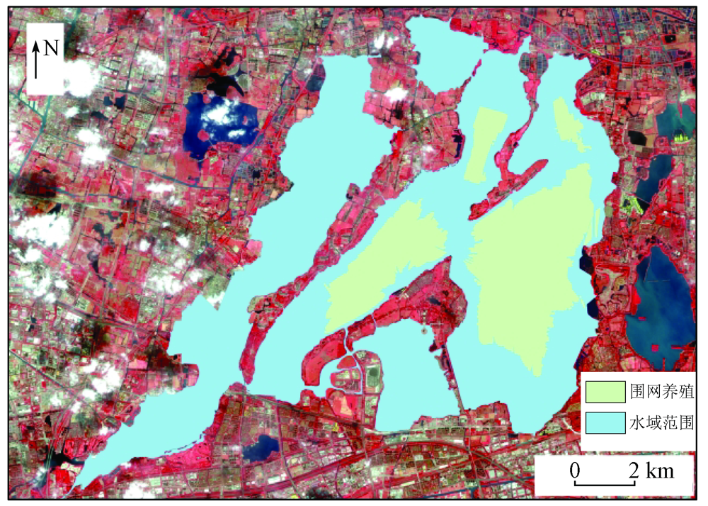
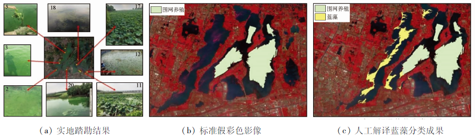
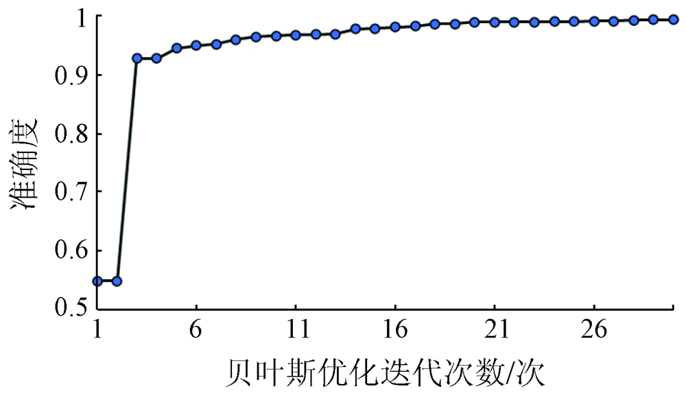
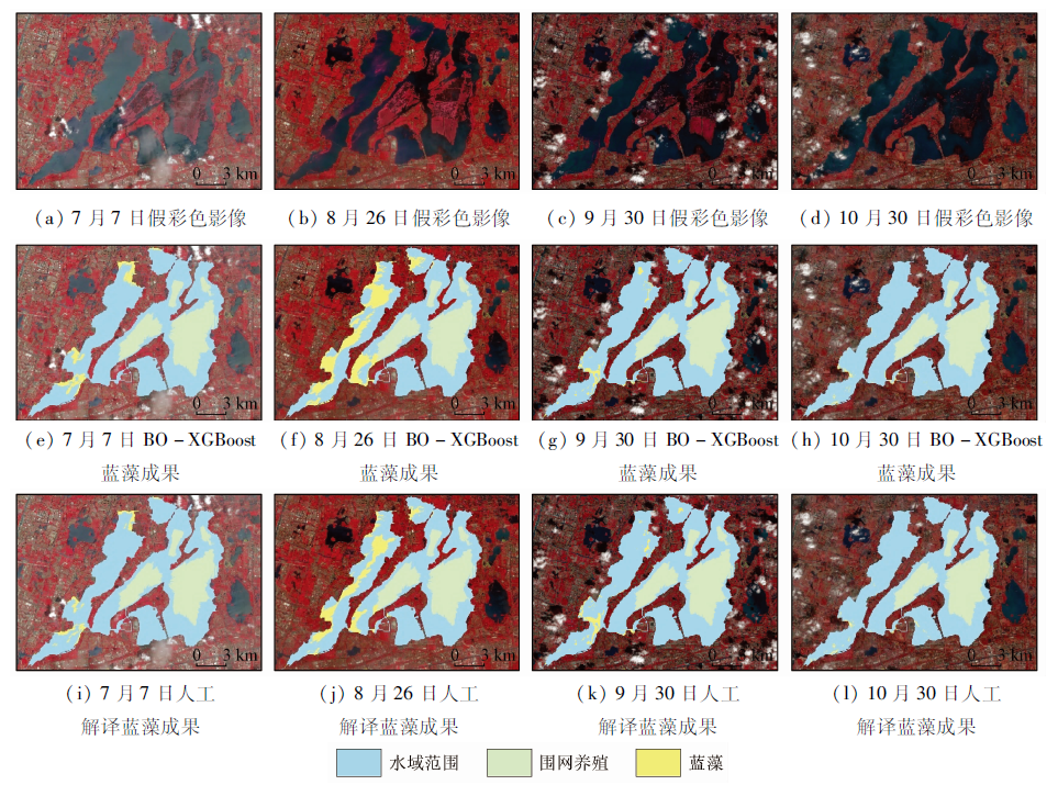
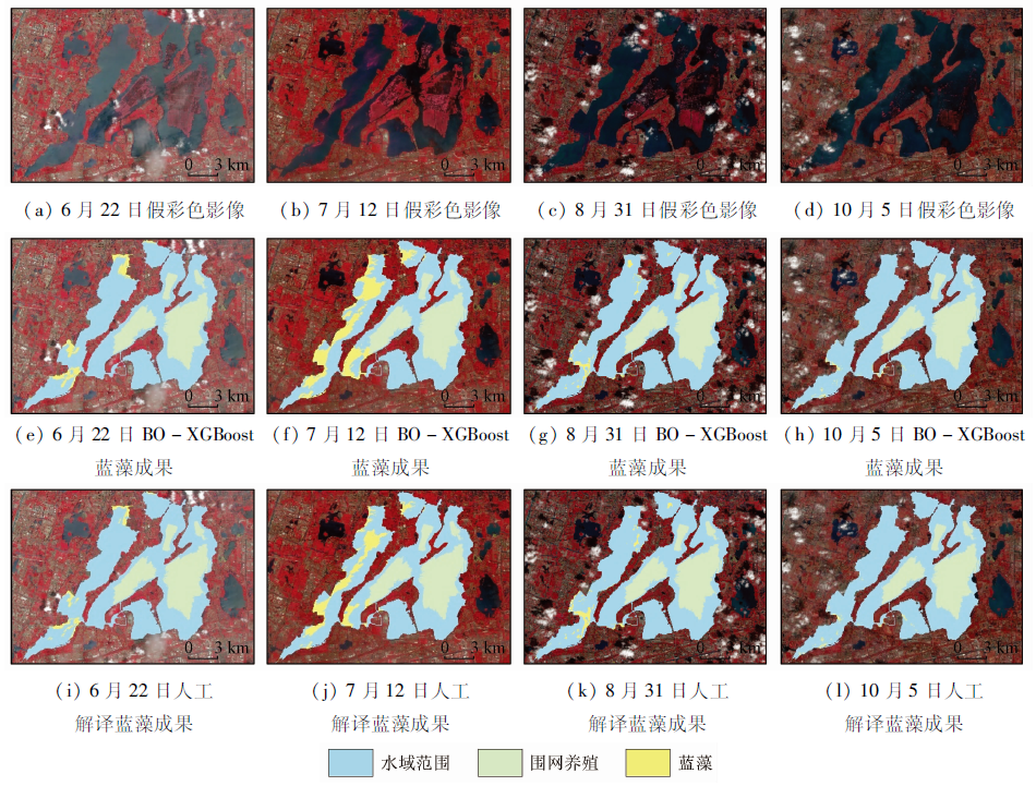
With 14 types of multi-feature information, such as spectrum, index, and texture, of remote sensing images from satellite Sentinel-2 as input and using the Bayesian optimization algorithm, this study designed the BO-XGBoost method used to automatically obtain the optimal hyperparameter combination. This method was successfully applied to the information extraction of cyanobacteria in Yangcheng Lake in 2021. The results show that: ① The optimal hyperparameter combination was obtained using the Bayesian optimization algorithm, and then the BO-XGBoost cyanobacteria classification model was established through obtaining. The training results performed well on the test and training sets, with an accuracy rate of up to 96.07%; ② The BO-XGBoost method was applied to the images used in the sample set. The comparison between the cyanobacteria identification results and the manual interpretation results shows that the two methods yielded roughly the same spatial distribution of cyanobacteria, with a lowest intersection over union (IoU) of 41.31%; ③ To evaluate the applicability of the BO-XGBoost method in other periods, images of other periods were selected for the information extraction of cyanobacteria. As a result, both BO-XGBoost and manual interpretation also yielded roughly the same spatial distribution of cyanobacteria, with a lowest IoU of 43.85%.
Hu Z H, Lin M L, Li G, et al. Phytoplankton community characteristics and influencing factors of the urban gate-controlled rivers[J]. Acta Scientiae Circumstantiae, 2021, 41(9):3631-3640.
Yan L, Long D, Bai L L, et al. A review on water resources stereoscopic monitoring systems based on multisource data[J]. National Remote Sensing Bulletin, 2020, 24(7):787-803.
Xie Y, Li K Y, Li J G, et al. Water pollution identification in Zhuhai City based on Sentinel-2A imagery[J]. Remote Sensing Information, 2021, 36(3):1-9.
Qiu Y H, Lu J B. Advances in the monitoring of Enteromorpha prolifera using remote sensing[J]. Acta Ecologica Sinica, 2015, 35(15):4977-4985.
[5]
Xing Q G, Hu C M. Mapping macroalgal blooms in the Yellow Sea and East China Sea using HJ-1 and Landsat data:Application of a virtual baseline reflectance height technique[J]. Remote Sensing of Environment, 2016, 178:113-126.
doi: 10.1016/j.rse.2016.02.065
Chen C B, Zhou B T, Tian Y Z, et al. Application of environmental satellite HJ1A/1B-CCD data for Cyanobacteria dynamic monitoring in Chaohu Lake[J]. Environmental Monitoring of China, 2014, 30(1):200-204.
[7]
Hu C. A novel ocean color index to detect floating algae in the global oceans[J]. Remote Sensing of Environment, 2009, 113(10):2118-2129.
doi: 10.1016/j.rse.2009.05.012
[8]
Fang C, Song K, Shang Y, et al. Remote sensing of harmful algal blooms variability for Lake Hulun using adjusted FAI (AFAI) Algorithm[J]. Journal of Environmental Informatics, 2018:54-68.
[9]
Otukei J R, Blaschke T. Land cover change assessment using decision trees,support vector machines and maximum likelihood classification algorithms[J]. International Journal of Applied Earth Observation and Geoinformation, 2010, 12:27-31.
doi: 10.1016/j.jag.2009.11.002
Li X Q, Liu S M, Li L, et al. Automatic interpretation of spatial distribution of winter wheat based on random forest algorithm to optimize multi-temporal features[J]. Transactions of the Chinese Society for Agricultural Machinery, 2019, 50(6):218-225.
Li L L, Pan Y Z, Zhang J S, et al. Method of winter wheat planting area estimation based on support vector machine and post-classification changed vector analysis[J]. Transactions of the Chinese Society of Agricultural Engineering, 2010, 26(9):210-217.
Zhao L, Zhang J S, Hu T G, et al. The application of the dynamic endmember linear spectral unmixing model to winter wheat area estimation[J]. Remote Sensing for Land and Resources, 2011, 23(1):66-72.doi:10.6046/gtzyyg.2011.01.13.
doi: 10.6046/gtzyyg.2011.01.13
Wang Y R, Wang S Q, Yu Y, et al. An adaptive threshold algorithm for detecting ulva prolifera in southern Yellow Sea by remote sensing[J]. Remote Sensing Information, 2021, 36(2):120-129.
[14]
Chen T W, Guestrin C. XGBoost:A scalable tree boosting system[C]// 22nd ACM SIGKDD International Conference.ACM, 2016.
Lu X M, Su H. Retrieving total suspended matter concentration in Fujian coastal waters using OLCI data[J]. Acta Scientiae Circumstantiae, 2020, 40(8):2819-2827.
Xu Y, Zhen J N, Jiang X P, et al. Mangrove species classification with UAV-based remote sensing data and XGBoost[J]. National Remote Sensing Bulletin, 2021, 25(3):737-752.
Li P, Feng C Q, Xu X G, et al. Ballistic target fretting classification network based on Bayesian optimization[J]. Journal of Xidian University, 2021, 48(5):139-148.
Sun S W, Xia T, Yang J Y, et al. An analysis of the phytoplankton community characteristics and nutrition status in lake-type drinking water sources in Suzhou[J]. China Rural Water and Hydropower, 2020(8):51-55.
Liu R Q, Li J L, Sun C, et al. Classification of Yancheng coastal wetland vegetation based on vegetation phenological characteristics derived from Sentinel-2 time-series[J]. Acta Geographica Sinica, 2021, 76(7):1680-1692.
doi: 10.11821/dlxb202107008
[21]
Guo X J, Zhang C C, Luo W R, et al. Urban impervious surface extraction based on multi-features and random forest[J]. IEEE Access, 2020, 8:226609-226623.
doi: 10.1109/Access.6287639
[22]
Bergstra J, Bardenet R, Bengio Y, et al. Algorithms for hyper-parameter optimization[J]. Advances in Neural Information Processing Systems, 2011, 24(24):2546-2554.
[23]
Tanaka R, Iwata H. Bayesian optimization for genomic selection:A method for discovering the best genotype among a large number of candidates[J]. Theoretical and Applied Genetics, 2017, 131(1):1-13.
doi: 10.1007/s00122-017-2954-9
[24]
Seeger M. Gaussian processes for machine learning[J]. International Journal of Neural Systems, 2004, 14(2):69-106.
pmid: 15112367
[25]
Colopy G W, Roberts S J, Clifton D A. Bayesian optimization of personalized models for patient vital-sign monitoring[J]. IEEE Journal of Biomedical and Health Informatics, 2018, 22(2):301.
doi: 10.1109/JBHI.2017.2751509
pmid: 29505398
Zhang D Y, Yin X, She B, et al. Using multi-source satellite imagery data to monitor cyanobacterial blooms of Chaohu Lake[J]. Infrared and Laser Engineering, 2019, 48(7):303-314.
Liu H Q, Ren H K, Niu X X, et al. Extraction of cyanobacteria bloom in Chaohu Lake based on Sentinel-2 remote sensing images[J]. Ecology and Environmental Sciences, 2021, 30(1):146-155.
 2023, Vol. 35
  ), 张金龙1, 金义蓉1, 董世元2(