Remote sensing identification and spatial distribution of dam areas with an area over 33.33 hm2 in Guizhou Province, China
HU Feng1,2(), LI Xue1,2, ZUO Jin3, SONG Shanhai1,2, TANG Hongxiang1,2, GU Xiaoping1,2()
1. Guizhou Ecological Meteorology and Satellite Remote Sensing Center, Guiyang 550002, China 2. Guizhou Data and Application Center for High-resolution Earth Observation Systtem, Guiyang 550002, China 3. Guizhou Institute of Mountainous Climate and Environment, Guiyang 550002, China
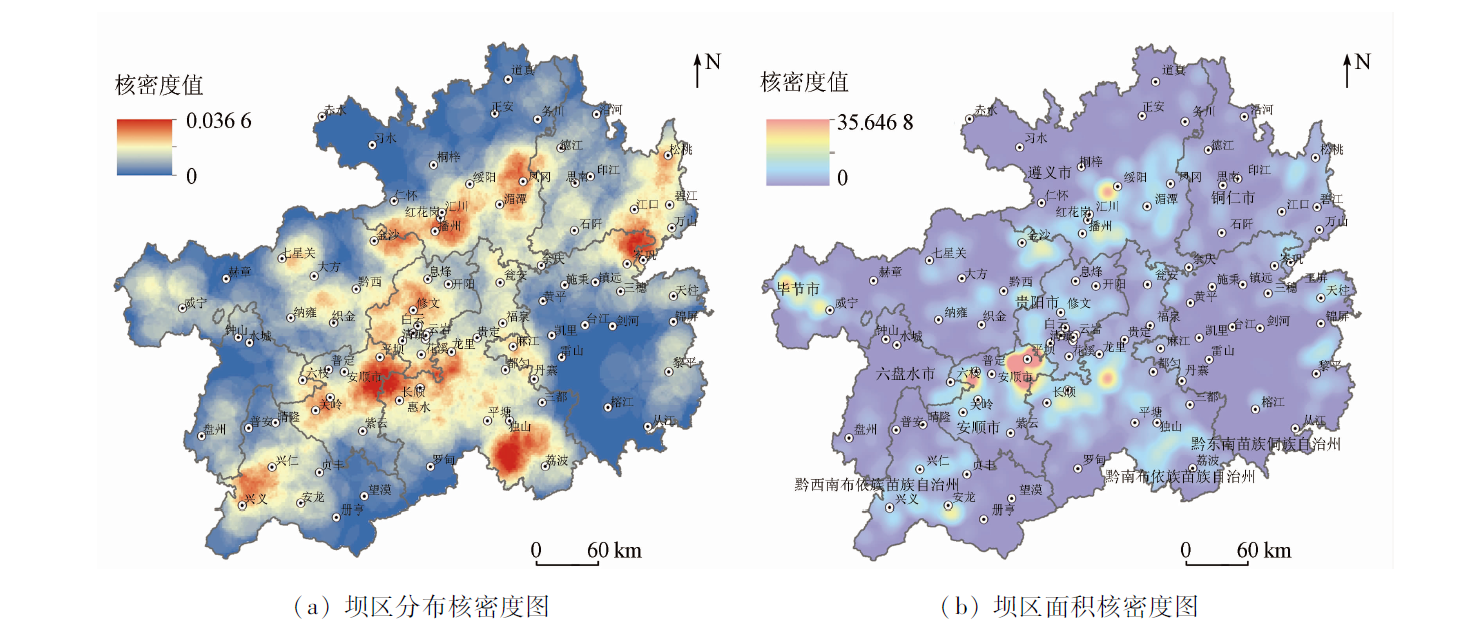
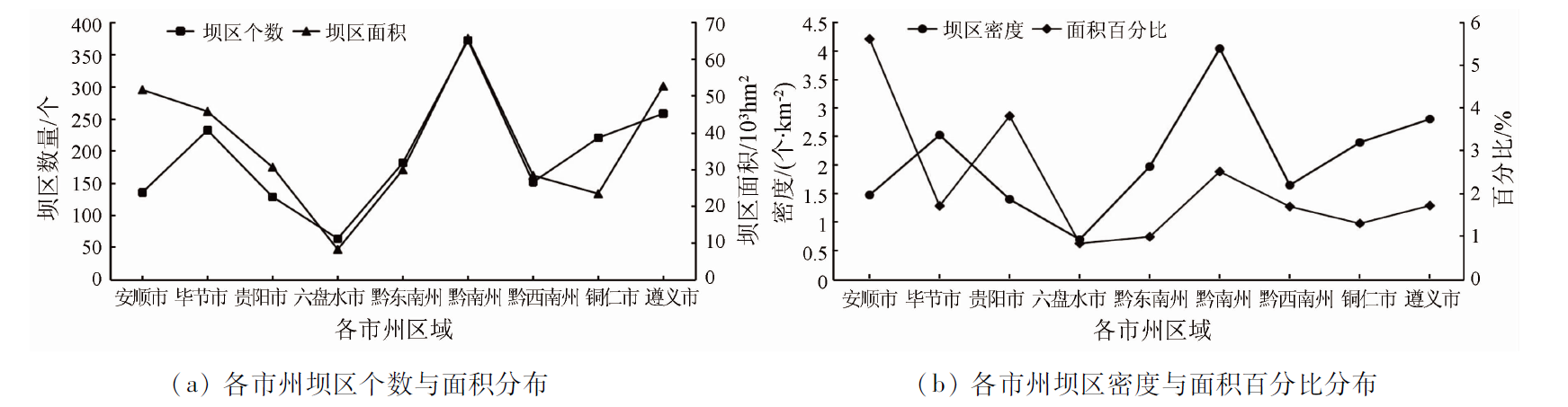
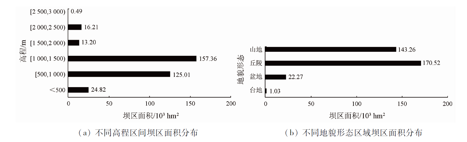
Featuring many mountains and few flatlands, Guizhou Province has scarce cultivated land resources. Consequently, dam areas become a main carrier for developing high-quality modern agriculture and increasing farmers’ income in Guizhou. The information extraction and characteristic research of dam areas can provide a scientific reference for the adjustment of the agricultural industrial structure and the sustainable utilization of land resources in Guizhou. With the domestic high-resolution satellite images of 2020 with a resolution of 2 m as the main data source, this study extracted, verified, and analyzed the remote sensing images of the dam areas with an area over 500 mu (33.33 hm2) using the global navigation satellite system (GNSS), the geographical information system (GIS), and remote sensing (RS). The remote sensing monitoring results are as follows: ① Guizhou has about 1 749 dam areas with an area of over 33.33 hm2 each, covering a total area of about 337 080.14 hm2, which account for 9.71% of the cultivated land; ② The dam areas with an area of 33.33~66.67 hm2 and 66.67~100 hm2 each account for the highest two proportions and account for 46.65% in total; ③ The dam areas mostly have small areas, with 32.05% on a scale of 10 000 mu (666.67 hm2). Moreover, there is not a proportional relationship between the number of dam areas and their area. The dam areas with an area of over 33.33 hm2 each are mainly distributed in the central region along the northeastern-southwestern area in Guizhou, with Qiannan Buyi and Miao Autonomous Prefecture, Zunyi City, and Anshun City ranking the top three in terms of area. The dam areas are dominated by those at altitudes of 1 000~1 500 m, which account for 46.68%. In addition, the dam areas are largely distributed in hilly and mountainous areas, with a few of them spreading in basins and platforms.
胡锋, 李雪, 左晋, 宋善海, 唐红祥, 谷晓平. 贵州500亩以上坝区遥感识别与空间分布特征研究[J]. 自然资源遥感, 2023, 35(2): 287-294.
HU Feng, LI Xue, ZUO Jin, SONG Shanhai, TANG Hongxiang, GU Xiaoping. Remote sensing identification and spatial distribution of dam areas with an area over 33.33 hm2 in Guizhou Province, China. Remote Sensing for Natural Resources, 2023, 35(2): 287-294.
Zhao Y L, Li X B, Zhang Y. Technology and application of mountainous area divisions in Qian-Gui Karst areas[J]. Journal of Geo-information Science, 2017, 19(7):934-940.
Han H Q, Yang G B, Zhang F T. Spatio-temporal analysis of land use changes in Guizhou Province based on landform characteristics[J]. Journal of Nanjing Forestry University (Natural Sciences Edition), 2015, 39(5):99-105.
Li Y B, Yao Y W, Zhou Z M. Study on the land use structure of Guizhou Province’s flatlands with≥10 000 mu//Liu Y S. Rural land consolidation and rural-urban harmonies development in China[M]. Guiyang: Guizhou Science Press, 2013.
[4]
《贵州省农业地貌区划》编写组. 贵州省农业地貌区划[M]. 贵阳: 贵州人民出版社, 1989.
The Compile Group of Agricultural Geomorphologic Regionalization in Guizhou Province. Agricultural geomorphologic regionalization in Guizhou Province[M]. Guiyang: Guizhou People Press, 1989.
Kou J M, Yi Z. Survey of 10 000 mu cultivated flatlands of Province Guizhou and atlas compilation[J]. Bulletin of Surveying and Mapping, 2005, 10:48-53.
[6]
贵州省国土资源厅. 贵州省万亩耕地大坝图集[M]. 长沙: 湖南地图出版社, 2005.
Department of Land and Resources of Guizhou Province. Atlas of 10 000 mu cultivated flatland of Guizhou Province[M]. Changsha: Hunan Map Press, 2005.
General Office of Guizhou Provincial People’s Government. Measures for the protection of planting land in dam areas of more than 500 mu in Guizhou Province[J]. Agricultural Technology Service, 2019, 36(2):7.
Sheng J L, Li Y B. The basins distribution of space and exploratory divide basin-mountain combination form different landforms in Guizhou Province[J]. Journal of Guizhou Normal University(Natural Sciences), 2018, 36(2):15-21,32.
Tong S Y, Chen Y S, Wang X L. A study on thecause of formation for flatland in Yunnan[J]. Yunnan Geo-Graphic Environment Research, 2007, 19(5):129-133,122.
Zhang S Q, Wang A H, Wang Y X, et al. Study on techniques and methods in demarcation of Bazi in Yunnan-Guizhou Plateau:Taking Yunnan Province as an example[J]. Surveying and Mapping of Geology and Mineral Resources, 2012, 28(4):1-4,8.
Yang Z M, Zhao Y L, Xue C L. Land use evolution and spatial differentiatio characteristics of mountain-basin system in karst area[J]. Chinese Journal of Agricultural Resources and Regional Planning, 2020, 41(7):153-162.
Yang Z S, Zhao Q G. Study on dividing flatland county,Semi-mountainous & semiflatland county and mountainous county in Yunnan Province based on the second national land survey[J]. Journal of Natural Resources, 2014, 29(4):564-574.
Yang G B, An Y L, Zhang Y M, et al. Thetechnology of discovering over 10 000 mu basins based on 3S in Guizhou Province[J]. Journal of Guizhou Norrmal University(Natural Sciences), 2003, 21(2):93-110.
Li J Y, Zhang Y Y, Hu K B. Discussion on the technical method of the present situation investigation of ten thousand mu dam land based on aerial images[J]. Beijing Surveying and Mapping, 2017 (6):68-71.
Ye W. Application of GIS and DEM technology in dam survey of ten thousand mu cultivated land in Guizhou[J]. Surveying and Mapping Bulletin, 2007 (1):60-61.
Li Q, Liu Y, Xu K P, et al. Research of area and distribution of flatland in Yunnan and Guizhou based on ecological spatial constraints[J]. China Environmental Science, 2013, 33(12):2215-2219.
Yao Y W, Li Y B, Jin Z G, et al. Analysis on land use change and driving forces of dam in Guizhou Province[J]. Resources and environment of Yangtze River Basin, 2014, 23 (1):67-74.
Yang X Y, Zhao Y L, Li X B. Analysis of land-use changes and Socio-economic factors in Karst mountainous areas of Guizhou and Guangxi[J]. Carsologica Sinica, 2019, 38(1):88-99.
Chen W H, Gan S. Lucc and its driving forces in mountain basins of Yunnan Province:A case study in Baoshan basin[J]. Yunnan Geographic Environment Research, 2009, 21(6):34-39.
Liu Y X, Li Y B. Spatial evolution of land use and production function in Bazi,Guizhou Province under the background of rural transformation[J]. Geographic Research, 2020, 39 (2):430-446.
Chen H, Li Y B, Tang J F. Distribution characteristics of modern agricultural functions in Bazi,Guizhou[J]. Progress in Earth Sciences, 2019, 34 (9):962-973.
Li Y B, Yao Y W, Xie J, et al. Spatial-temporalevolution of land use and landscape pattern of the mountain-basin system in Guizhou Province[J]. Acta Ecologica Sinica, 2014, 34(12):3257-3265.
Liu Y X, Li Y B, Yi X S, et al. Spatial evolution of land use intensity and landscape pattern response of the typical basins in Guizhou Province,China[J]. Chinese Journal of Applied Ecology, 2017, 28(11):3691-3702.
Yao Y W, Li Y B, Long D M. Land cover change and landscape pattern of Guizhou Huangjia 10 000-Mu basins[J]. Guizhou Agricultural Sciences, 2015, 43(1):179-184.
Li Y B, Chen H, Luo G J. Spatial distribution of different scale flatland in Guizhou Province,China[J]. Scientia Geographica Sinica, 2019, 39(11):1830-1840.
Han D J, Zhu D L. Coupling relationship analysis of land use and regional economy in Guizhou Province[J]. Transactions of the Chinese Society of Agricultural Engineering, 2012, 28(15):1-8.
Zhang M J. Analysis on the present situation of industrial development in dam area of more than 500 mu in Guizhou[J]. Journal of Anshun University, 2021, 23(4):38-41.
Wang Y M, Wang M X, Wu D T, et al. Spatial patterns and determinants of rural poverty:A Case of Guizhou Province,China[J]. Scientia Geographica Sinica, 2017, 37(2):217-227.
[30]
杨明德. 论贵州岩溶水赋存的地貌规律性[J]. 中国岩溶, 1982,(2):85-91.
Yang M D. The geomorphological of Karst water occurences in Guizhou plateau[J]. Carsologica Sinica, 1982,(2):81-91.
[31]
李宗发. 贵州喀斯特地貌分区[J]. 贵州地质, 2011, 28(3):177-181.
Li Z F. Division of Karst landform in Guizhou[J]. Guizhou Geology, 2011, 28(3):177-181,234.
 2023, Vol. 35
  ), 李雪1,2, 左晋3, 宋善海1,2, 唐红祥1,2, 谷晓平1,2(