Spatio-temporal variations in mangrove forests in the Shankou Mangrove Nature Reserve based on the GEE cloud platform and Landsat data
SHI Min1,2(), LI Huiying1(), JIA Mingming3
1. School of Environmental and Municipal Engineering, Qingdao University of Technology, Qingdao 266520, China 2. College of Geography, Nanjing Normal University, Nanjing 210023, China 3. Key Laboratory of Wetland Ecology and Environment, Northeast Institute of Geography and Agroecology, Chinese Academy of Sciences, Changchun 130102, China
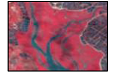
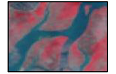
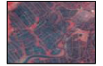
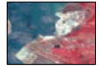
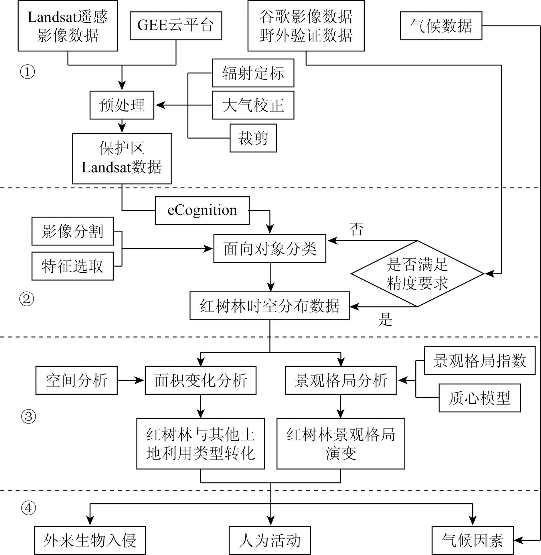
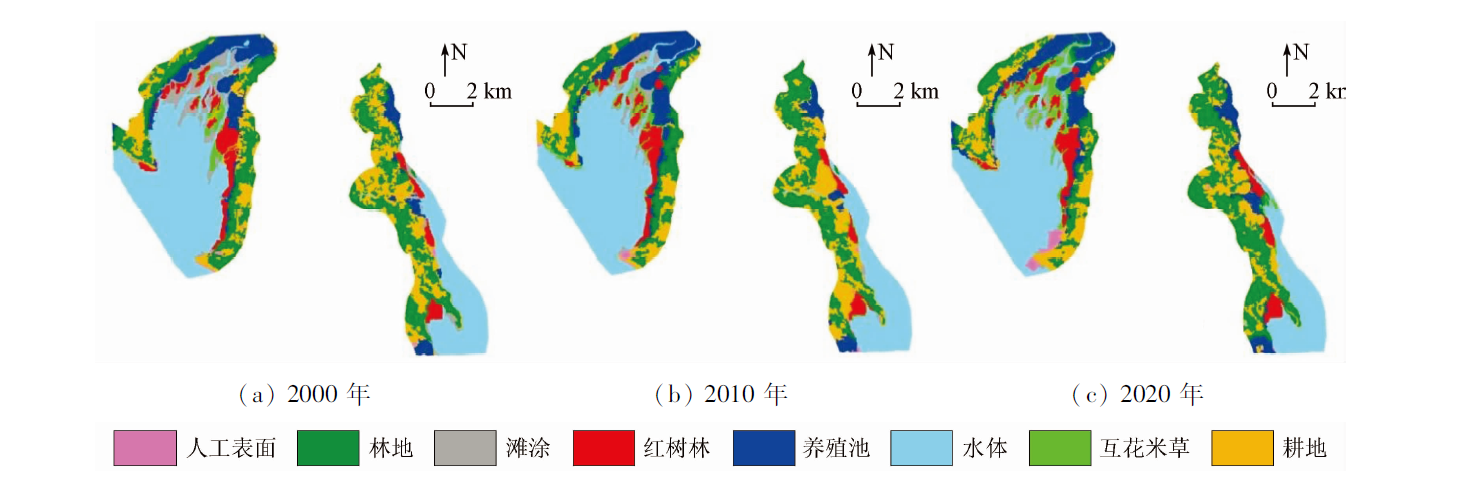
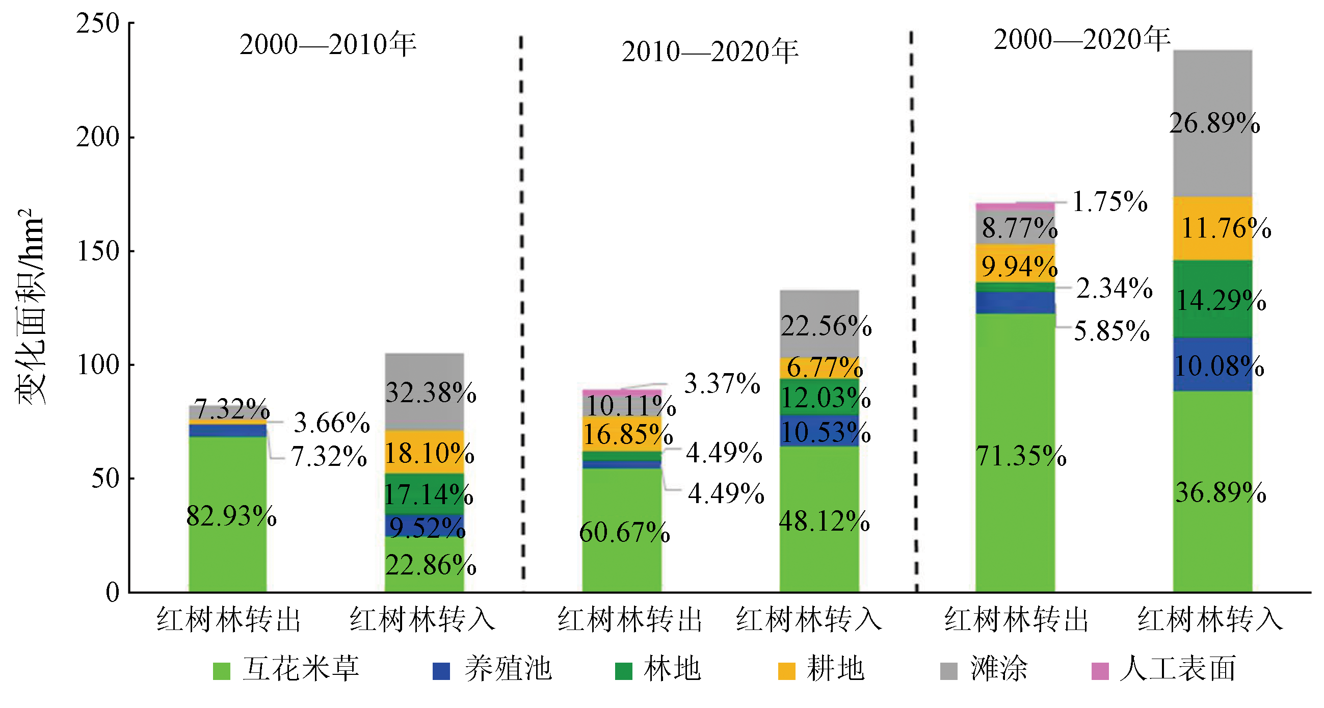
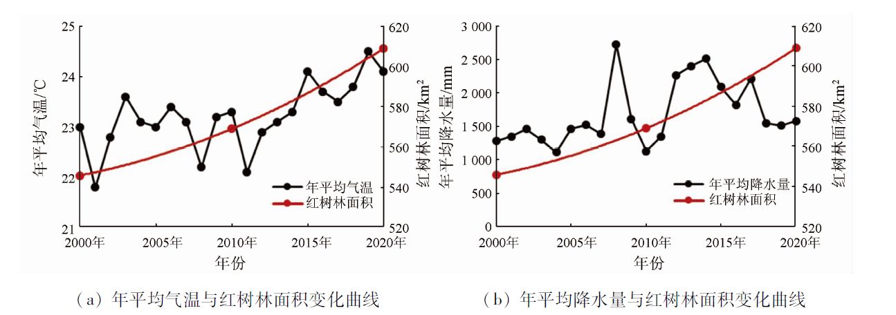
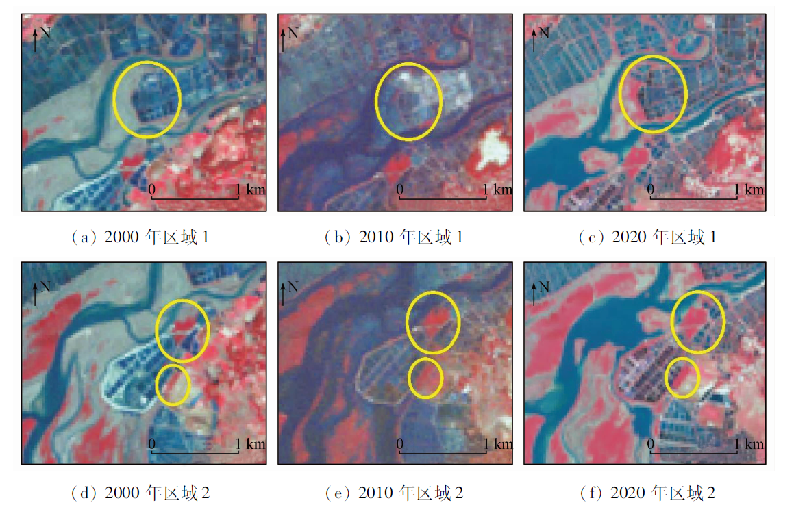
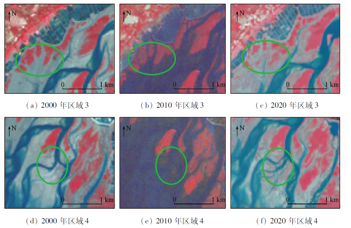
Conventional processing methods for remote sensing data are inefficient and time-consuming. Using the object-oriented classification method this study extracted the distribution of mangrove forests of 2000, 2010, and 2020 in the Shankou Mangrove Nature Reserve in Guangxi based on the GEE cloud platform and Landsat TM/OLI remote sensing data. Then, this study monitored the spatio-temporal variations in mangrove forests in the study area in combination with the landscape analysis method and revealed their driving factors. The results are as follows: ① During 2000—2020, the mangrove forests in the study area increased by about 63 hm2, including a significant increase of about 40 hm2 during 2010—2020; ② Compared with other land use types, the mangrove forests showed the most intense conversion with spartina alterniflora areas and mudflats, with 152 hm2 of spartina alterniflora areas and mudflats being converted to mangrove forests and 122 hm2 of mangrove forests being converted to spartina alterniflora areas over the 20 years; ③ During 2000—2020, the mangrove landscape in the study area showed decreased fragmentation, increased patch aggregation, continuously expanded landscape dominance, and landward migration of the mangrove forest centroid; ④ Among the factors affecting the area of mangrove forests in the nature reserve, the control of invasive vegetation and moderate aquaculture can increase the area of mangrove forests, while climate changes and invasive vegetation had adverse effects on the growth of mangrove forests. The results of this study will provide a method reference and data basis for the conservation and management of mangrove wetlands in Shankou, Guangxi.
石敏, 李慧颖, 贾明明. 基于GEE云平台与Landsat数据的山口自然保护区红树林时空变化分析[J]. 自然资源遥感, 2023, 35(2): 61-69.
SHI Min, LI Huiying, JIA Mingming. Spatio-temporal variations in mangrove forests in the Shankou Mangrove Nature Reserve based on the GEE cloud platform and Landsat data. Remote Sensing for Natural Resources, 2023, 35(2): 61-69.
Jia M M. Remote sensing analysis of China’s mangrove forests dynamics during 1973 to 2013[D]. Changchun: University of Chinese Academy of Sciences, 2014.
Wang H, Ren G B, Wu P Q, et al. Analysis on the remote sensing monitoring and landscape pattern change of mangrove in China from 1990 to 2019[J]. Journal of Ocean Technology, 2020, 39(5):1-12.
Yang S C, Lu W X, Zou Z, et al. Mangrove wetlands:Distribution,species composition and protection in China[J]. Subtropical Plant Science, 2017, 46(4):301-310.
Jia M M, Wang Z M, Mao D H, et al. Spatial-temporal changes of China’s mangrove forests over the past 50 years: An analysis towards the sustainable development goals(SDGs)[J]. Chinese Science Bulletin, 2021, 66(30):3886-3901.
[5]
Jia M M, Wang Z M, Li L, et al. Mapping China’s mangroves based on an object-oriented classification of Landsat imagery[J]. Wetlands: The Journal of the Society of Wetland Scientists, 2014, 34(2):277-283.
[6]
Murrary N J, Keith D A, Bland L M, et al. The role of satellite remote sensing in structured ecosystem risk assessments[J]. Science of the Total Environment, 2018,619-620:249-257.
Li C G, Tan B Z. A study on romote sensing image processing approaches for mangrove in ventory[J]. Central South Forest Inventory and Planning, 2003(2):24-27.
Li T H, Zhao Z J, Han P. Detetion and analyis of mangrove changes with multitemporal remotely sensed imagey in the Shenzhen River estuary[J]. National Remote Sensing Bulletin, 2002(5):364-369,403.
Wang W X, Su F Z, Feng X, et al. Study on the difference of mangrove in Beibu Bay between China and Vietnam[J]. Journal of Geo-Information Science, 2017, 19(2):264-272.
Chu L X. Anthropogenic influence on coastal environment using satellite cloud-based platform[D]. Beijing: China University of Geosciences (Beijing), 2019.
[11]
Diniz C, Cortinhas L, Nerino G, et al. Brazilian mangrove status:Three decades of satellite data analysis[J]. Remote Sensing, 2019, 11(7):808.
doi: 10.3390/rs11070808
[12]
Gilani H, Naz H I, Arshad M, et al. Evaluating mangrove conservation and sustainability through spatiotemporal (1990—2020) mangrove cover change analysis in Pakistan[J]. Estuarine,Coastal and Shelf Science, 2021, 249:107128.
doi: 10.1016/j.ecss.2020.107128
[13]
Pimple U, Simonetti D, Hinks I, et al. A history of the rehabilitation of mangroves and an assessment of their diversity and structure using Landsat annual composites (1987—2019) and transect plot inventories[J]. Forest Ecology and Management, 2020, 462:118007.
doi: 10.1016/j.foreco.2020.118007
[14]
Chamberlain D A, Phinn S R, Possingham H P. Mangrove forest cover and phenology with Landsat dense time series in central Queensland,Australia[J]. Remote Sensing, 2021, 13(15):3032.
doi: 10.3390/rs13153032
Zhu Y J, Guo J L, Wu G J, et al. Mangrove landscape changing process and land use coverage change of its surrounding areas in Yingluo Bay,southern China during the past 20 years[J]. Journal of Beijing Forestry University, 2013, 35(2):22-29.
Mo C R, Li Y, Li X M, et al. Grain size effect on landscape pattern indexes of Yingluo Mangrove Nature Reserve[J]. Science Technolo-gy and Engineering, 2012, 12(26):6725-6730,6742.
Huang G M. The growth characteristics of spartina alterniflora and relative competitive ability with kandelia obovata in mangrove areas of Zhangjiang Estuary[D]. Xiamen: Xiamen University, 2009.
[19]
Walter V. Object-based classifieation of remote sensing data for change detection[J]. Journal of Photogrammetry and Remote Sensing, 2004, 58:225-238.
doi: 10.1016/j.isprsjprs.2003.09.007
[20]
Lacaux J P, Tourre Y M, Vignolles C, et al. Classification of ponds from high-spatial resolution remote sensing:Application to Rift Valley fever epidemics in Senegal[J]. Remote Sensing of Environment, 2006, 106(1):66-74.
doi: 10.1016/j.rse.2006.07.012
Li H Y, Li X Y, Jia M M, et al. Impacts of summer flood occurred in north of Sanjiang Plain in 2013 on landscape of marshes[J]. Wetland Science, 2015, 13(3):344-349.
Cui L J, Li W, Zhang M Y, et al. Changes in landscape pattern of mangrove wetlands and their driving force in the Luoyang River estuary,Fujian Province[J]. Journal of Beijing Forestry University, 2010, 32(2):106-112.
Liu M Y. Remote sensing analysis of spartina alterniflora in the coastal areas of China during 1999 to 2015[D]. Northeast Institute of Geography and Agroecology, Beijing: University of Chinese Academy of Sciences, 2018.
Lu C Y, Lin P, Ye Y, et al. Effects of global climate change on mangrove ecosystem and research countermeasures[J]. Advances in Earth Science, 1995(4):341-347.
Lu C Y, Gao Y B, Chen Y L, et al. Dynamic change analysis of mangrove swamps based on RS/GIS in Quanzhou Bay[J]. Journal of Forest and Environment, 2019, 39(2):143-152.
Lin J. The “coast guard” of protecting green:Record of mangrove protection and development in Shankou,Guangxi[J]. Disaster Reduction in China, 2018(16):22-27.
 2023, Vol. 35
  ), 李慧颖1(