Factors influencing the terrain modeling accuracy of UAV photogrammetry based on Monte Carlo tests of control points
CHEN Kai1,2(), WANG Chun1,2,3(), DAI Wen1, SHENG Yehua4,5, LIU Aili1, TANG Guoan4,5
1. School of Geographical Sciences, Nanjing University of Information Science and Technology, Nanjing 210044, China 2. School of Geographic Information and Tourism, Chuzhou University, Chuzhou 239000, China 3. Anhui Province Key Laboratory of Physical Geographic Environment, Chuzhou 239000, China 4. School of Geography, Nanjing Normal University, Nanjing 210023, China 5. Key Laboratory of Virtual Geographic Environment, Ministry of Education, Nanjing Normal University, Nanjing 210023, China
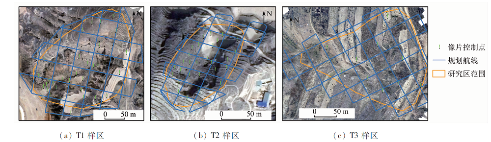
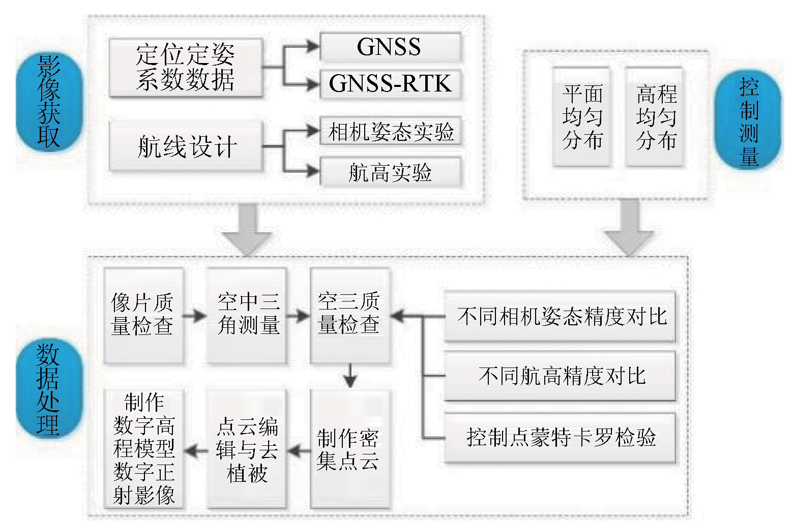
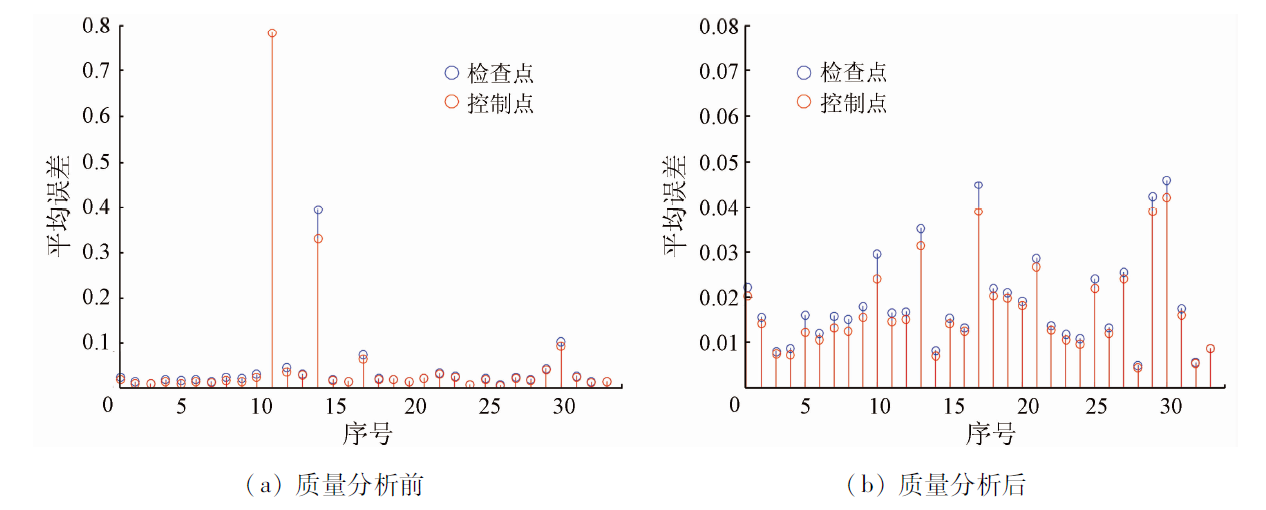
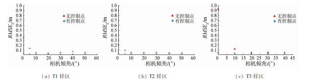
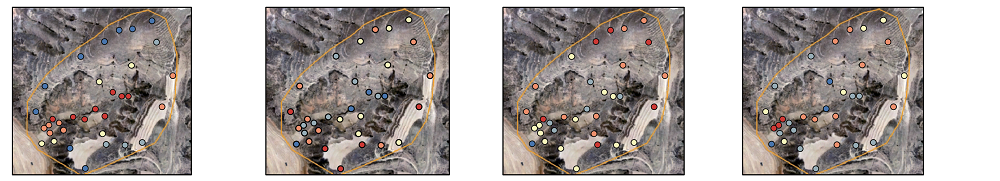
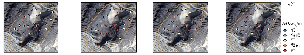
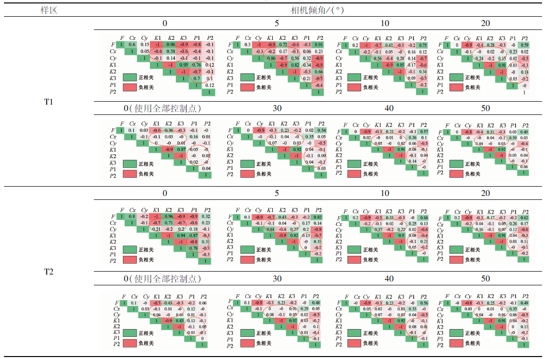
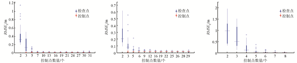
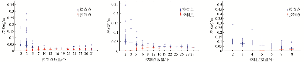
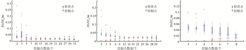
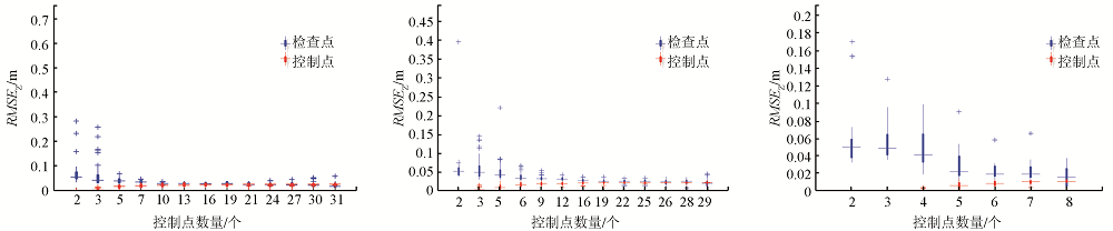
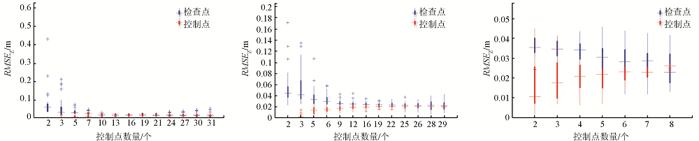
Consumer-grade unmanned aerial vehicles (UAVs) each have a single camera and high lens distortion. The accuracy of terrain modeling using UAVs is influenced by route design and control surveys. By designing different data collection schemes and Monte Carlo tests, this study investigated the influence of the camera’s tilt angle, flight height, and the number of ground control points (GCPs) on terrain modeling accuracy in three small river basins on the Loess Plateau. The results are as follows: ① Before the processing of UAV photogrammetry data, it is necessary to analyze the quality of GCPs through Monte Carlo tests to eliminate GCP errors. ② The effects of the tilt angles of cameras include: in the case of no available GCPs, tilt photogrammetry with tilt angles of cameras can both improve the overall accuracy of the sampling area and optimize the spatial distribution of errors, with these advantages related to the optimization of the camera distortion model; in the case of available GCPs, the camera tilt angle has minor influence on elevation accuracy but affects the saturation number of GCPs. Compared with vertical photogrammetry, tilt photogrammetry requires slightly more GCPs to achieve the optimal accuracy. ③ The effects of the flight height include: in the case of no available GCPs, tilt photogrammetry can reduce the sensitivity of elevation accuracy to flight height; in the case of available GCPs, flight heights of 60~160 m have no significant influence on elevation accuracy, and the change in flight height does not affect the saturation number of GCPs.
陈凯, 王春, 代文, 盛业华, 刘爱利, 汤国安. 基于控制点蒙特卡罗检验的无人机地形建模精度影响因素研究[J]. 自然资源遥感, 2023, 35(3): 107-115.
CHEN Kai, WANG Chun, DAI Wen, SHENG Yehua, LIU Aili, TANG Guoan. Factors influencing the terrain modeling accuracy of UAV photogrammetry based on Monte Carlo tests of control points. Remote Sensing for Natural Resources, 2023, 35(3): 107-115.
James M R, Robson S, Smith M W. 3-D uncertainty-based topographic change detection with structure-from-motion photogrammetry:Precision maps for ground control and directly georeferenced surveys[J]. Earth Surface Processes and Landforms, 2017, 42(12):1769-1788.
doi: 10.1002/esp.v42.12
Yang S T, Wang P F, Wang J, et al. River flow estimation method based on UAV aerial photogrammetry[J]. National Remote Sensing Bulletin, 2021, 25(6): 1284-1293.
doi: 10.11834/jrs.20209082
Dai W, Tang G A, Hu G H, et al. Modelling sediment transport in space in a watershed based on topographic change detection by UAV survey[J]. Progress in Geography, 2021, 40(9):1570-1580.
doi: 10.18306/dlkxjz.2021.09.011
Liu S C, Shao Q Q, Yang F, et al. Using UAVs remote sensing for population and distribution of grazing livestock in the source region of the Yellow River[J]. Journal of Geo-Information Science, 2021, 23(7): 1286-1295.
[5]
James M R, Chandler J H, Eltner A, et al. Guidelines on the use of structure-from-motion photogrammetry in geomorphic research[J]. Earth Surface Processes and Landforms, 2019, 44(10):2081-2084.
doi: 10.1002/esp.4637
Liu J L, Liao X H, Ni W J, et al. Individual tree recognition algorithm of UAV stereo imagery considering three-dimensional morphology of tree[J]. Journal of Geo-Information Science, 2021, 23(10): 1861-1872.
[7]
Agüera-Vega F, Carvajal-Ramírez F, Martínez-Carricondo P, et al. Reconstruction of extreme topography from UAV structure from motion photogrammetry[J]. Measurement, 2018, 121: 127-138.
doi: 10.1016/j.measurement.2018.02.062
[8]
James M R, Robson S. Straightforward reconstruction of 3D surfaces and topography with a camera:Accuracy and geoscience application[J]. Journal of Geophysical Research(Earth Surface), 2012, 117(f3):3-17.
[9]
张祖勋, 张剑清. 数字摄影测量学(第2版)[M]. 武汉: 武汉大学出版社, 2012.
Zhang Z X, Zhang J Q. Digiital photogrammetry(second edition)[M]. Wuhan: Wuhan University Press, 2012.
[10]
Nesbit P, Hugenholtz C. Enhancing UAV-SfM 3D model accuracy in high-relief landscapes by incorporating oblique images[J]. Remote Sensing, 2019, 11(3):239.
doi: 10.3390/rs11030239
[11]
Bemis S P, Micklethwaite S, Turner D, et al. Ground-based and UAV-based photogrammetry:A multi-scale,high-resolution mapping tool for structural geology and paleoseismology[J]. Journal of Structural Geology, 2014, 69: 163-178.
doi: 10.1016/j.jsg.2014.10.007
[12]
James M R, Robson S. Mitigating systematic error in topographic models derived from UAV and ground-based image networks[J]. Earth Surface Processes and Landforms, 2014, 39(10):1413-1420.
doi: 10.1002/esp.v39.10
[13]
Carbonneau P E, Dietrich J T. Cost-effective non-metric photogrammetry from consumer-grade sUAS:Implications for direct georeferencing of structure from motion photogrammetry[J]. Earth Surface Processes and Landforms, 2017, 42(3):473-486.
doi: 10.1002/esp.v42.3
[14]
Carvajal-Ramírez F, Agüera-Vega F, Martínez-Carricondo P J. Effects of image orientation and ground control points distribution on unmanned aerial vehicle photogrammetry projects on a road cut slope[J]. Journal of Applied Remote Sensing, 2016, 10(3):034004.
doi: 10.1117/1.JRS.10.034004
[15]
Rossi P, Mancini F, Dubbini M, et al. Combining nadir and oblique UAV imagery to reconstruct quarry topography:Methodology and feasibility analysis[J]. European Journal of Remote Sensing, 2017, 50(1):211-221.
doi: 10.1080/22797254.2017.1313097
[16]
Smith M W, Vericat D. From experimental plots to experimental landscapes:Topography,erosion and deposition in sub-humid badlands from structure-from-motion photogrammetry[J]. Earth Surface Processes and Landforms, 2015, 40(12):1656-1671.
doi: 10.1002/esp.v40.12
Zhang C B, Yang S T, Zhao C S, et al. Topographic data accuracy verification of small consumer UAV[J]. Journal of Remote Sensing, 2018, 22(1):185-195.
[18]
Cabo C, Sanz-Ablanedo E, Roca-Pardinas J, et al. Influence of the number and spatial distribution of ground control points in the accuracy of UAV-SfM DEMs:An approach based on generalized additive models[J]. IEEE Transactions on Geoscience and Remote Sensing, 2021, 59(12):10618-10627.
doi: 10.1109/TGRS.2021.3050693
Sang W G, Li N, Han F, et al. Research on the control point layout scheme for consumption-grade UAV oblique photogrammetry in small areas and modeling accuracy[J]. Bulletin of Surveying and Mapping, 2019(10):93-96.
doi: 10.13474/j.cnki.11-2246.2019.0325
[20]
James M R, Robson S, D’oleire-Oltmanns S, et al. Optimising UAV topographic surveys processed with structure-from-motion:Ground control quality,quantity and bundle adjustment[J]. Geomorphology, 2017, 280: 51-66.
doi: 10.1016/j.geomorph.2016.11.021
[21]
国家测绘局. 低空数字航空摄影规范[M]. 北京: 中国测绘出版社, 2010: 15-16.
State Bureau of Surveying and Mapping. Specification for low altitude digital aerial photography[M]. Beijing: Surveying and Mapping Press, 2010: 15-16.
[22]
Antoniazza G, Bakker M, Lane S N. Revisiting the morphological method in two dimensions to quantify bed-material transport in braided rivers[J]. Earth Surface Processes and Landforms, 2019, 44(11):2251-2267.
doi: 10.1002/esp.4633
Surveying adjustment discipline group, School of Surveying and Mapping, Wuhan University. Error theory and basis of measurement adjustment[M]. Wuhan: Wuhan University Press, 2014.
 2023, Vol. 35
  ), 王春1,2,3(