Exploring the spatio-temporal variations and influencing factors of vegetation cover in Yunnan Province
LI Yimin1,2(), FENG Xianjie3, LI Yuanting3, YANG Xue1, XIANG Qianying3, JI Peikun1
1. School of Earth Sciences, Yunnan University, Kunming 650500, China 2. Research Center of Domestic High-resolutellite Remote Sensing Geological Engineering, Kunming 650500, China 3. Institute of International Rivers and Eco-Security, Yunnan University, Kunming 650500, China
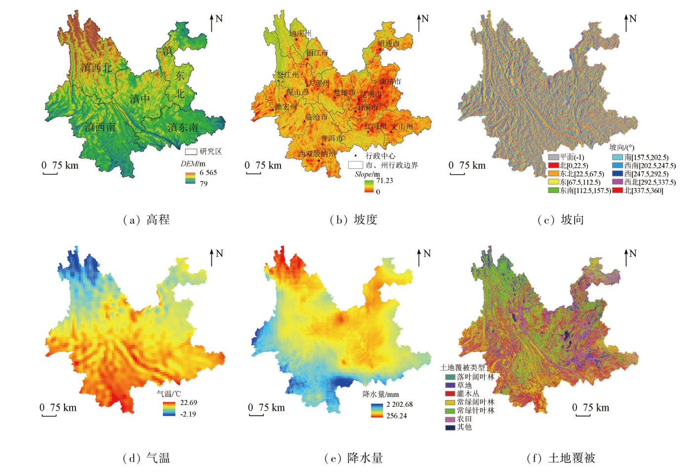
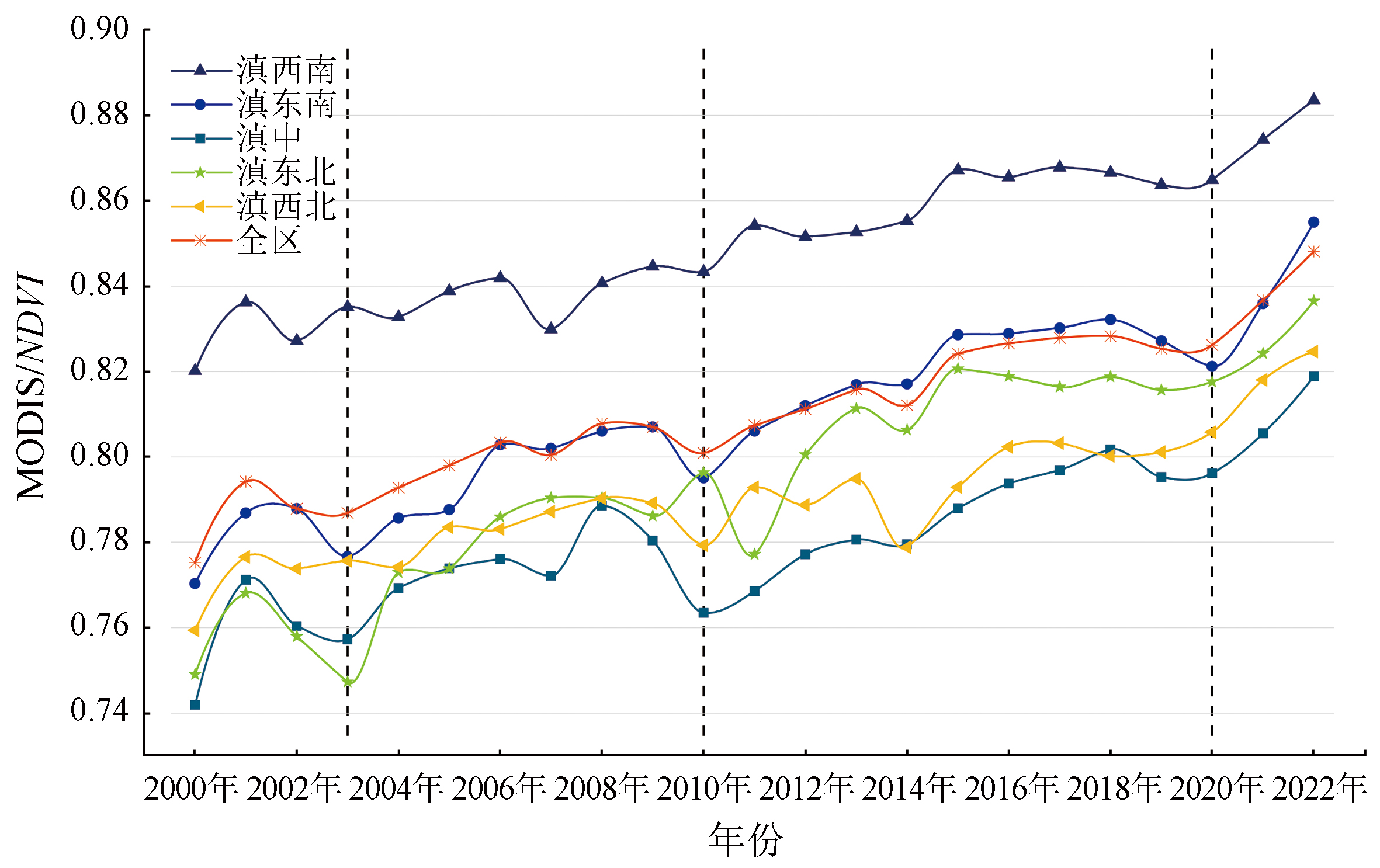
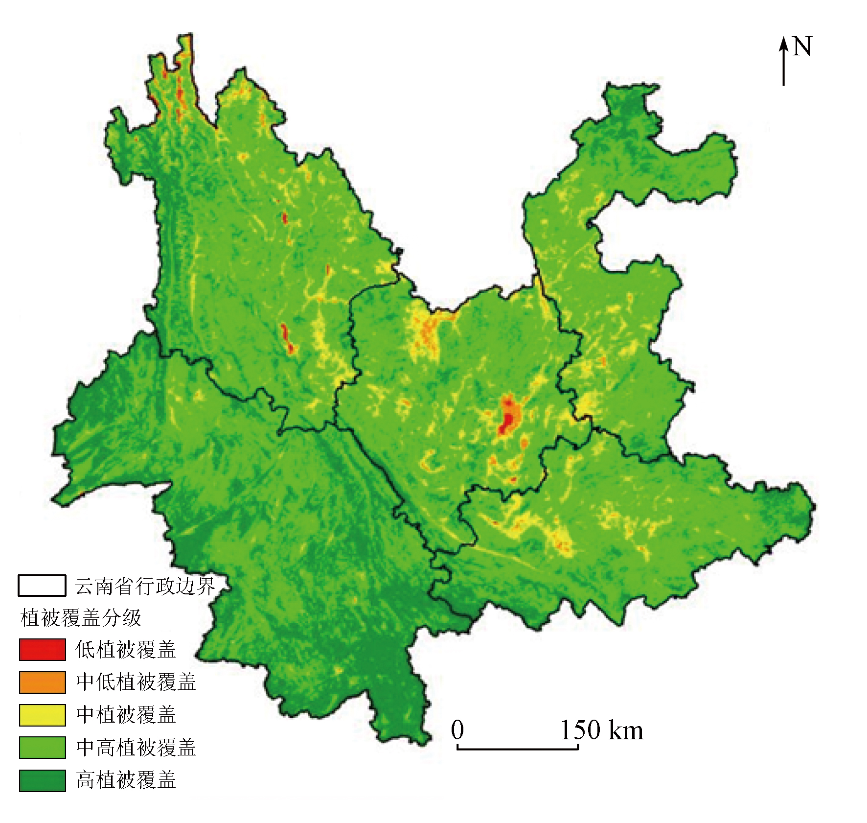
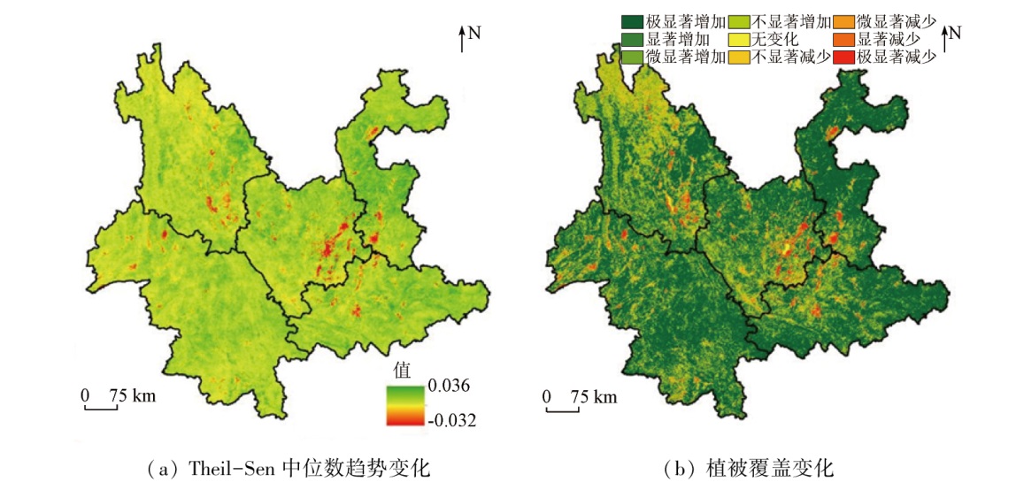
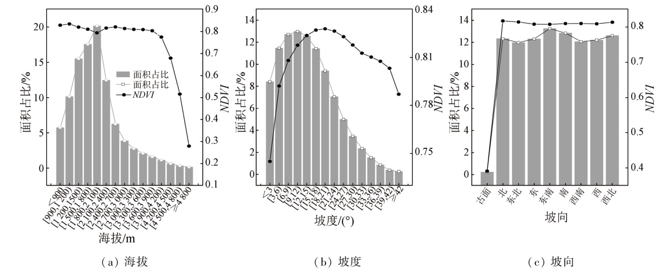
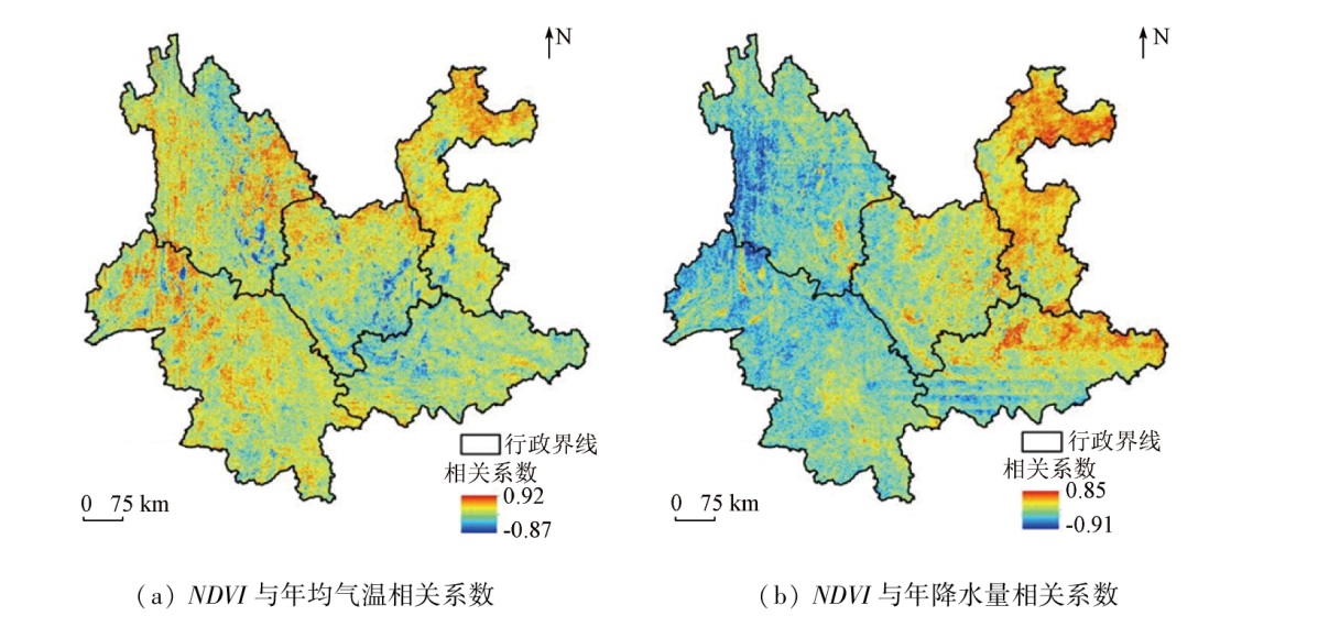
Yunnan Province has abundant species resources but fragile ecosystems, and the ecological vulnerability is closely related to vegetation cover. Hence, based on the normalized difference vegetation index (NDVI) from the MOD13Q1 dataset for 2000—2022, this study dynamically monitored the spatio-temporal variations of vegetation using the maximum value composite (MVC), Theil-Sen median trend analysis, and Mann-Kendall significance test. Moreover, this study delved into the response of vegetation to factors like topography, climate change, and land cover through correlation analysis. The results show that: ① From 2000 to 2022, the overall vegetation coverage of Yunnan Province was relatively high, with average annual NDVI values ranging from 0.74 to 0.90, showing a fluctuating upward trend. Of the whole area, 91.17% exhibited an increasing vegetation coverage trend, with the fastest growth rate seen in northeastern Yunnan; ② Regional differences were observed in vegetation cover, which was higher in southeastern and southwestern Yunnan compared to northwestern, central, and northeastern Yunnan; ③ The NDVI values of Yunnan Province were relatively stable below the altitude of 3 900 m, and decreased with increasing altitude in the case of over 3 900 m; ④ The NDVI values were the lowest with slopes below 3°, and with an increase in slope, they increased first and then decreased; ⑤ The planar slope aspect displayed the lowest NDVI values, and other slope aspects showed minimal impact on vegetation growth; ⑥ From 2000 to 2022, the vegetation cover in central, southeastern, and northeastern Yunnan was positively correlated with precipitation, suggesting that precipitation in these areas was favorable for vegetation growth. However, the vegetation cover in southwestern and northwestern Yunnan showed a negative correlation with precipitation. Additionally, the vegetation cover in the whole region and various areas was positively correlated with temperature, suggesting that temperature is beneficial to vegetation growth. The results of this study will provide a scientific basis for strengthening ecological environment construction and ecological management in Yunnan Province.
李益敏, 冯显杰, 李媛婷, 杨雪, 向倩英, 计培琨. 云南省植被覆盖时空变化特征及影响因素研究[J]. 自然资源遥感, 2024, 36(2): 116-125.
LI Yimin, FENG Xianjie, LI Yuanting, YANG Xue, XIANG Qianying, JI Peikun. Exploring the spatio-temporal variations and influencing factors of vegetation cover in Yunnan Province. Remote Sensing for Natural Resources, 2024, 36(2): 116-125.
Li J J, Peng S Z, Li Z. Detecting and attributing vegetation changes on China’s Loess Plateau[J]. Agricultural and Forest Meteorology, 2017, 247:260-270.
Yang Y P, Chen J J, Qin Q T, et al. Temporal and spatial variation of vegetation and its response to topography,climate and land use in Guangxi during 2000—2018[J]. Transactions of the Chinese Society of Agricultural Engineering, 2021, 37(17):234-241.
Miao B L, Liang C Z, Han F, et al. Responses of phenology to climate change over the major grassland types[J]. Acta Ecologica Sinica, 2016, 36(23):7689-7701.
Lu J, Wang X F, Cao Y Q. Effects of climate and human activities on vegetation change in Liaoning Province[J]. Advances in Science and Technology of Water Resources, 2022, 42(4):7-14,38.
Jin K, Wang F, Han J Q, et al. Contribution of climatic change and human activities to vegetation NDVI change over China during 1982-2015[J]. Acta Geographica Sinica, 2020, 75(5):961-974.
doi: 10.11821/dlxb202005006
Lu J X, Zhou R L, Liu Y Y, et al. Temporal and spatial dynamics of vegetation cover on the Loess Plateau and its influencing factors[J]. Research of Soil and Water Conservation, 2023, 30(2):211-219.
Wu J H. Monitoring species diversity and measuring vegetation resilience with satellite remote sensing[J]. Acta Geodaetica et Cartographica Sinica, 2022, 51(8):1826.
doi: 10.11947/j.AGCS.2022.20200539
Zheng Z J, Zeng Y, Zhao Y J, et al. Monitoring and dynamic analysis of fractional vegetation cover in southwestern China over the past 15 years based on MODIS data[J]. Remote Sensing for Land and Resources, 2017, 29(3):128-136.doi:10.6046/gtzyyg.2017.03.19.
Xiong J N, Peng C, Cheng W M, et al. Analysis of vegetation coverage change in Yunnan Province based on MODIS-NDVI[J]. Journal of Geo-Information Science, 2018, 20(12):1830-1840.
Zhao A Z, Liu X F, Zhu X F, et al. Spatiotemporal analyses and associated driving forces of vegetation coverage change in the Loess Plateau[J]. China Environmental Science, 2016, 36(5):1568-1578.
Liu Z, Qiu B W, Wang Z Z, et al. Temporal and spatial variation analysis of vegetation cover in the Loess Plateau from 2001 to 2014[J]. Remote Sensing for Land and Resources, 2017, 29(1):192-198.doi:10.6046/gtzyyg.2017.01.29.
[12]
Li S S, Yang S N, Liu X F, et al. NDVI-Based analysis on the influence of climate change and human activities on vegetation restoration in the Shaanxi-Gansu-Ningxia region,Central China[J]. Remote Sensing, 2015, 7(9):11163-11182.
[13]
Pang G J, Wang X J, Yang M X. Using the NDVI to identify variations in,and responses of,vegetation to climate change on the Tibetan Plateau from 1982 to 2012[J]. Quaternary International, 2017, 444:87-96.
[14]
Chu H S, Venevsky S, Wu C, et al. NDVI-based vegetation dynamics and its response to climate changes at Amur-Heilongjiang River Basin from 1982 to 2015[J]. The Science of the Total Environment, 2019, 650(Pt 2):2051-2062.
doi: S0048-9697(18)33557-5
pmid: 30290347
[15]
Zoungrana B J, Conrad C, Thiel M, et al. MODIS NDVI trends and fractional land cover change for improved assessments of vegetation degradation in Burkina Faso,West Africa[J]. Journal of Arid Environments, 2018, 153:66-75.
Yang H J, Zhang C H. Research on the effective route of ecological civilization construction in Yunnan Province based on System Dynamics[J]. China Population,Resources and Environment, 2019, 29(2):16-24.
Ruan H W, Yu J J. Changes in land cover and evapotranspiration in the five Central Asian countries from 1992 to 2015[J]. Acta Geographica Sinica, 2019, 74(7):1292-1304.
doi: 10.11821/dlxb201907002
[18]
Yang Y J, Wang S J, Bai X Y, et al. Factors affecting long-term trends in global NDVI[J]. Forests, 2019, 10(5):372.
[19]
Gocic M, Trajkovic S. Analysis of changes in meteorological variables using Mann-Kendall and Sen’s slope estimator statistical tests in Serbia[J]. Global and Planetary Change, 2013, 100:172-182.
Meng Q, Wu Z T, Du Z Q, et al. Quantitative influence of regional fractional vegetation cover based on geodetector model:Take the Beijing-Tianjin sand source region as an example[J]. China Environmental Science, 2021, 41(2):826-836.
Huang H B, Xu H L, Lin T, et al. Spatio-temporal variation characteristics of NDVI and its response to climate change in the Altay region of Xinjiang from 2001 to 2020[J]. Acta Ecologica Sinica, 2022, 42(7):2798-2809.
Liang S Z, Yu D F, Wang M, et al. Application of remote sensing time — series data to investigate the relationship between vegetation change and climatic factors:A case study of Circum — Bohai Sea area[J]. Remote Sensing for Land and Resources, 2015, 27(3) :114-121.doi:10.6046/gtzyyg.2015.03.19.
 2024, Vol. 36
  ), 冯显杰3, 李媛婷3, 杨雪1, 向倩英3, 计培琨1