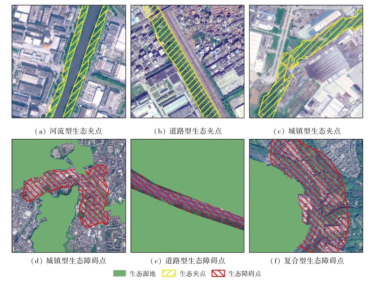
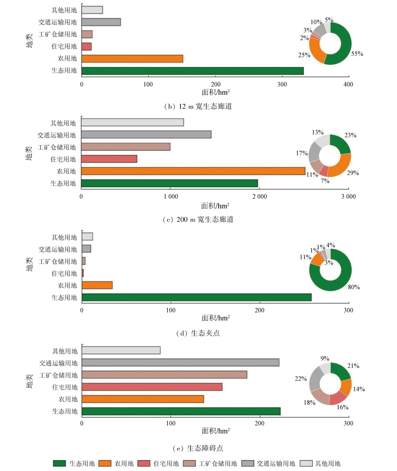
Constructing ecological security patterns in territorial space can constrain and guide urban spatial development for coordinated and sustainable development of cities and regional environments. Based on the remote sensing ecological index and the minimum cumulative resistance model, this study identified the ecological security pattern factors for Dongguan City, Guangdong Province, including ecological source area, ecological corridor, ecological pinch point, and ecological barrier. Moreover, this study proposed related optimization recommendations. The results of this study indicate that: ① Dongguan City exhibits a favorable ecological base, contiguous ecological spaces, and evenly distributed ecological corridors that can effectively connect ecological source areas; ② Enhanced waterfront space protection and road greening construction provide effective paths for the flow of ecological elements; ③ Agricultural production and transportation manifest the most significant effects on ecological networks, followed by industrial production and domestic life; ④ Ecological sources, 12-m-wide ecological corridors, and ecological pinch points can be classified as key ecological protection areas, while 200-m-wide ecological corridors and ecological barriers can be categorized into key ecological restoration areas. This study will provide a scientific basis for constructing the ecological security pattern in territorial space for Dongguan.
刘永林, 高益忠, 陈明辉, 邱玲. 广东省东莞市国土空间生态安全格局构建与分析[J]. 自然资源遥感, 2024, 36(2): 126-134.
LIU Yonglin, GAO Yizhong, CHEN Minghui, QIU Ling. Construction and analysis of the ecological security pattern in territorial space for Dongguan City, Guangdong Province. Remote Sensing for Natural Resources, 2024, 36(2): 126-134.
Wu M Q, Hu M M, Wang T, et al. Recognition of urban ecological source area based on ecological security pattern and multi-scale landscape connectivity[J]. Acta Ecologica Sinica, 2019, 39(13):4720-4731.
Su C, Dong J Q, Ma Z G, et al. Identifying priority areas for ecological protection and restoration of mountains-rivers-forests-farmlands-lakes-grasslands based on ecological security patterns:A case study in Huaying Mountain,Sichuan Province[J]. Acta Ecologica Sinica, 2019, 39(23):8948-8956.
Wu J S, Zhang L Q, Peng J, et al. The integrated recognition of the source area of the urban ecological security pattern in Shenzhen[J]. Acta Ecologica Sinica, 2013, 33(13):4125-4133.
Peng J, Guo X N, Hu Y N, et al. Constructing ecological security patterns in mountain areas based on geological disaster sensitivity:A case study in Yuxi City,Yunnan Province,China[J]. Chinese Journal of Applied Ecology, 2017, 28(2):627-635.
Wu J, Li R J, Cheng P G. City ecological source recognition and ecological corridor construction[J]. Science of Surveying and Mapping, 2022, 47(4):175-180.
Deng J J, Chen L X, Yang C Y, et al. Significance evaluation of ecological corridor in an highly-urbanized areas:A case study of Shenzhen[J]. Geographical Research, 2017, 36(3):573-582
Zhang J Y, Shan L L. Necessity and feasibility analysis of constructing urban ecological network[J]. Journal of Green Science and Technology, 2014(2):14-17.
Luo H J, Ming D P, Xu L. Time series calculation of remote sensing ecological index based on GEE[J]. Remote Sensing for Natural Resources, 2022, 34(2):271-277.doi:10.6046/zrzyyg.2021150.
Zuo L, Sun L G, Lu J J, et al. MODIS-based comprehensive assessment and spatial-temporal change monitoring of ecological quality in Beijing-Tianjin-Hebei region[J]. Remote Sensing for Natural Resources, 2022, 34(2):203-214.doi:10.6046/zrzyyg.2021224.
Chen X, Liu H H, Li J H, et al. Coupling coordination analysis of urbanization and ecological environment based on nighttime light remote sensing[J]. Remote Sensing for Natural Resources, 2022, 34(4):280-285.doi:10.6046/zrzyyg.2021369.
Song Q, Feng C H, Ma Z Q, et al. Simulation of land use change in oasis of arid areas based on Landsat images from 1990 to 2019[J]. Remote Sensing for Natural Resources, 2022, 34(1):198-209.doi:10.6046/zrzyyg.2021042.
Li Y M, Yang S T, Wu B W, et al. Spatiotemporal evolution of impervious surface and the driving factors in Chenggong District,Kunming City[J]. Remote Sensing for Natural Resources, 2022, 34(2):136-143.doi:10.6046/zrzyyg.2020187.
Ying K, Li X D, Cheng D Y. Remote sensing assessment of ecological environment quality in karst trough basin[J]. Remote Sensing for Land and Resources, 2020, 32(3):173-182.doi:10.6046/gtzyyg.2020.03.23.
Zhang Q R, Zhao L J, Lin G J, et al. Ecological environment assessment of three-river confluence in Yibin City using improved remote sensing ecological index[J]. Remote Sensing for Natural Resources, 2022, 34(1):230-237.doi:10.6046/zrzyyg.2021058.
Wang S Y, Zhao C L, Chen X, et al. Remote sensing-based green space evolution in Tangshan and its influence on heat island effect[J]. Remote Sensing for Natural Resources, 2022, 34(2):168-175.doi:10.6046/zrzyyg.2021198.
Wang M Y, Xu H Q. A comparative study on the changes in heat island effect in Chinese and foreign megacities[J]. Remote Sensing for Natural Resources, 2021, 33(4):200-208.doi:10.6046/zrzyyg.2020393.
[19]
Knaapen J P, Scheffer M, Harms B. Estimating habitat isolation in landscape planning[J]. Landscape and Urban Planning, 1992, 23(1):1-16.
Yang K, Cao Y G, Feng Z, et al. Research progress of ecological security pattern construction based on minimum cumulative resistance model[J]. Journal of Ecology and Rural Environment, 2021, 37(5):555-565.
[21]
Cui X F, Deng W, Yang J X, et al. Construction and optimization of ecological security patterns based on social equity perspective:A case study in Wuhan,China[J]. Ecological Indicators, 2022, 136:108714.
Hou X F, Qu Q, Jiang Y Z. Establishing the ecological security pattern of Jieyang City with GIS[J]. Journal of South China Normal University(Natural Science Edition), 2021, 53(3):83-92.
Liu Z Z, Wu W, Liu W F, et al. Study on construction land reduction based on “Source-Corridor” ecological security pattern paradigm[J]. Acta Ecologica Sinica, 2020, 40(22):8230-8238.
Yuan Y, Bai Z K, Shi X Y, et al. Determining priority areas for ecosystem preservation and restoration of territory based on ecological security pattern:A case study in Zunhua City,Hebei Province[J]. Chinese Journal of Ecology, 2022, 41(4):750-759.
Ni Q P, Ding Z Y, Hou H P, et al. Ecological pattern recognition and protection based on circuit theory[J]. Journal of Arid Land Resources and Environment, 2019, 33(5):67-73.
[26]
McRae B H, Hall S A, Beier P, et al. Where to restore ecological connectivity? Detecting barriers and quantifying restoration benefits[J]. PLoS One, 2012, 7(12):e52604.
 2024, Vol. 36
  ), 高益忠, 陈明辉(