Ecological vulnerability of highland mountain areas:A case study of Kangding City, Sichuan Province
SU Yue1(), LIU Hong1,2(), YANG Wunian2, OUYANG Yuan1, ZHANG Jinghua1, ZHANG Tengjiao1, HUANG Yong1
1. Chengdu Center of China Geological Survey, Chengdu 610081,China 2. College of Earth Sciences, Chengdu University of Technology, Chengdu 610059, China
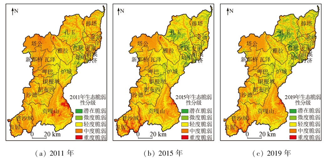
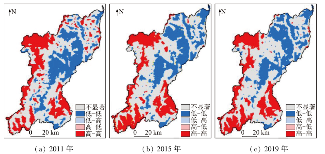
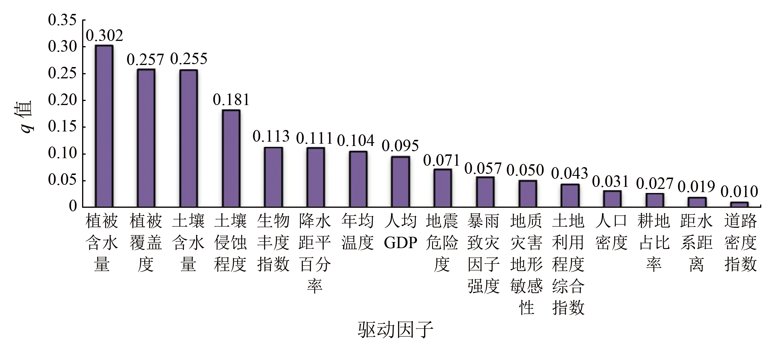
This study constructed an assessment index system for ecological vulnerability based on the vulnerability scoping diagram (VSD) model. It dynamically assessed the three-phase ecological vulnerability of Kangding City from 2011 to 2019 using the analytic hierarchy process - principal component analysis - entropy weight method (AHP-PCA-EWM). Through the analysis of spatio-temporal variations, spatial correlations, and driving factors, it revealed the spatio-temporal differentiation characteristics and driving mechanism of Kangding’s ecological vulnerability, aiming to provide suggestions for the ecological restoration, conservation, and sustainable development of Kangding. The results of this study are as follows: ① Throughout the study period, Kangding exhibited an overall moderate ecological vulnerability, with increased potentially- and slightly-vulnerable areas and a decreased severely vulnerable area, suggesting a promising ecological evolutionary trend. Moreover, the ecological vulnerability of Kangding manifested spatial distributions characterized by high-high clusters in the western and southeastern portions and low-low clusters in the northeastern and middle portion; ② The spatial distributions of ecological vulnerability in Kangding were subjected to various internal and external factors, with natural driving factors like vegetation cover, biological abundance, soil and water conservation, and meteorology being the dominant ones.
Tian Y P, Chang H. Bibliometric analysis of research progress on ecological vulnerability in China[J]. Acta Geographica Sinica, 2012, 67(11):1515-1525.
doi: 10.11821/xb201211008
Yang Z W, Zhang M Z, Xing Q F. On the development trend of ecological vulnerability in recent thirty years[J]. Journal of Heihe University, 2022, 13(6):184-188.
Yao J, Ai N S, Ding J. Progress in the studies of eco-environmental fragility and assessment in China[J]. Journal of Lanzhou University(Natural Sciences), 2003(3):77-80.
Zhao Y B, Ni Z Y, Ouyang Y, et al. Research progress of eco-geological environment carrying capacity[J]. Sedimentary Geology and Tethyan Geology, 2022, 42(4):529-541.
Liu H, Huang H X, Ouyang Y, et al. Soil’s geologic investigation in Daliangshan,Xichang,Sichuan[J]. Sedimentary Geology and Tethyan Geology, 2020, 40(1):91-105.
Zhang L K, Qin X Q, Huang Q B, et al. Aquatic plants bioremediation to groundwater contaminated by mines in karst areas[J]. Carsologica Sinica, 2017, 36(5):743-750.
Xu Z Y. Spatial-temporal dynamics of ecosystem health in Sichuan Province based on PSR model[J]. Remote Sensing for Land and Resources, 2020, 32(2):251-258.doi:10.6046/gtzyyg.2020.02.32.
[9]
Polsky C, Neff R, Yarnal B. Building comparable global change vulnerability assessments:The vulnerability scoping diagram[J]. Global Environmental Change-Human and Policy Dimensions, 2007, 17(3/4):472-485.
Ma L L, Tian S F, Wang N. Ecological environment evaluation of the mining area based on AHP and fuzzy mathematics[J]. Remote Sensing for Land and Resources, 2013, 25(3):165-170.doi:10.6046/gtzyyg.2013.03.27.
Pan P F, Yang W N, Dai X A. Vegetation moisture content model based on principal component analysis[J]. Remote Sensing for Land and Resources, 2013, 25(3):38-42.doi:10.6046/gtzyyg.2013.03.07.
Shao Q F, Peng P H, Huang J, et al. Monitoring eco-environmental vulnerability in Anning River Basin in the upper reaches of the Yangtze River using remote sensing techniques[J]. Remote Sensing for Land and Resources, 2016, 28(2):175-181.doi:10.6046/gtzyyg.2016.02.27.
Lin X M, Li W F, Wang H, et al. Analysis of the groundwater storage variations and their driving factors in the three eastern coastal urban agglomerations of China[J]. Remote Sensing for Natural Resources, 2022, 34(4):262-271.doi:10.6046/zrzyyg.2022007.
Yao K, Zhang C J, He L, et al. Dynamic evaluation and prediction of ecological environment vulnerability in the middle-upper reaches of the Yalong River[J]. Remote Sensing for Land and Resources, 2020, 32(4):199-208.doi:10.6046/gtzyyg.2020.04.25.
Zhou M Y. The method system and case study of a vulnerability assessment of mountain ecological system in semi-arid and arid areas[D]. Shanghai: East China Normal University, 2017.
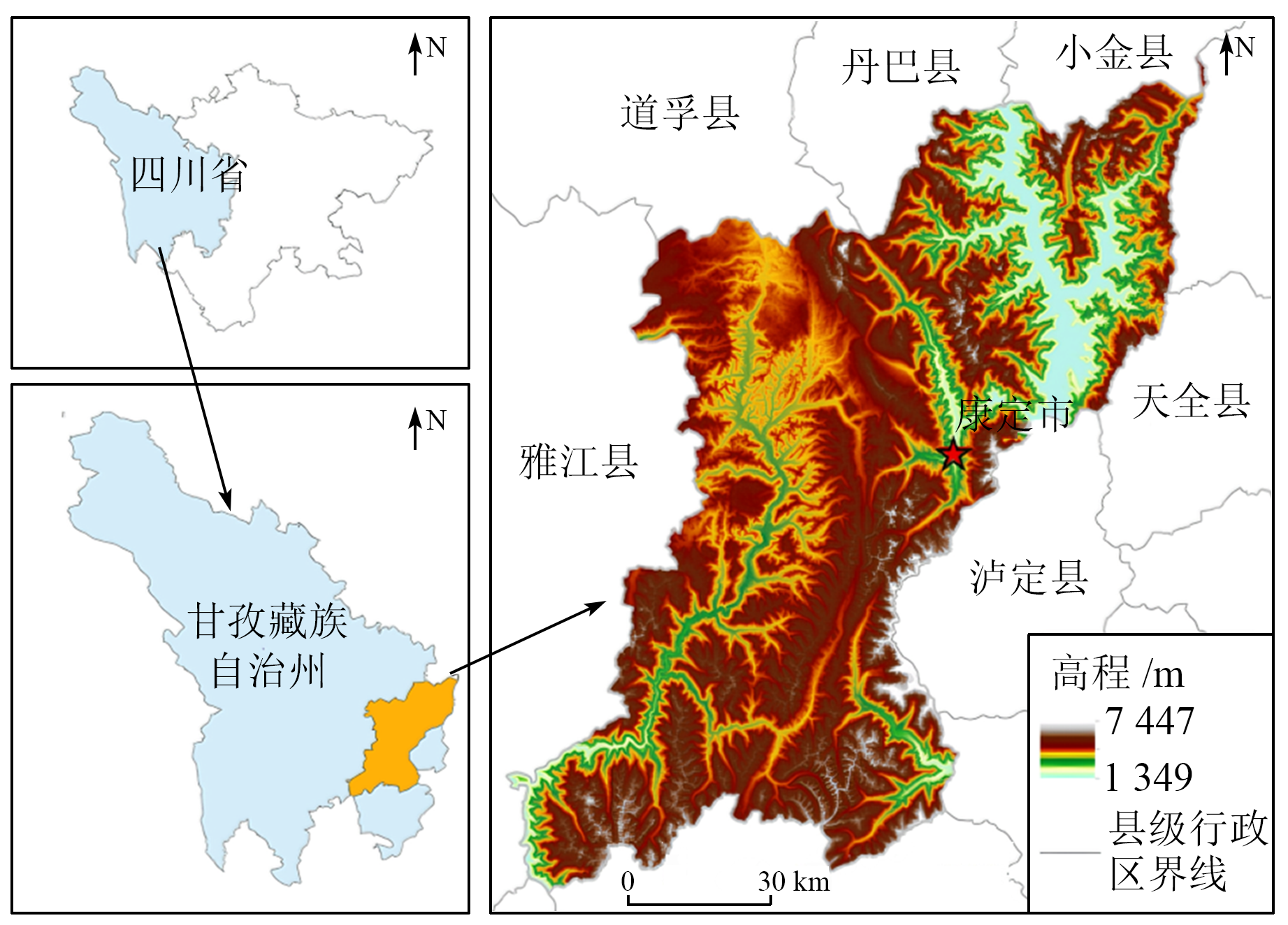
Zheng W M, Ba R J, Liu Y J, et al. Risk evaluation of urban seismogeology and geological hazards in Kangding,western Sichuan[J]. Sedimentary Geology and Tethyan Geology, 2012, 32(3):75-78.
Jia J, Bai J H, Deng W, et al. On the landscape pattern evolution and its motivating factors in Kangding City in the past two decades[J]. Journal of Safety and Environment, 2017, 17(4):1571-1577.
Zhou Z Q, Zhang Z Y. Analysis of spatial distribution and management measures of degraded grassland in Kangding County[J]. Journal of Sichuan Forestry Science and Technology, 2015, 36(3):55-61.
Fan G F, He Y, Gu J Q. The rainstorm disaster and its risk assessment based on GIS in Zhejiang Province[J]. Chinese Agricultural Science Bulletin, 2012, 28(32):293-299.
doi: 10.11924/j.issn.1000-6850.2012-1273
Huang R Q, Li W L. Analysis of the number and density of landslides triggered by the 2008 Wenchuan earthquake,China[J]. Journal of Geological Hazards and Environment Preservation, 2009, 20(3):1-7.
[23]
向明顺. 地震重灾区生态环境遥感动态监测与评价研究[D]. 成都: 成都理工大学, 2018.
Xiang M S. Rremote sensing based on dynamic monitoring and evaluation of Eco-environmental change in earthquake-striken areas—a case study in Beichuan county,Sichuan Province,China[D]. Chengdu: Chengdu University of Technology, 2018.
[24]
罗新蕊. 岷江上游茂县植被冠层生态水遥感定量反演[D]. 成都: 成都理工大学, 2019.
Luo X R. Quantifying vegetation canopy eco-water using remote sensing in Maoxian,upper reaches of Mingjiang river[D]. Chengdu: Chengdu University of Technology, 2019.
Zhang L K, Yang H. Transport process of arsenic in karst subterranean stream and analysis on the influence factors:A case in Lihu subterranean stream of Nandan County,Guangxi[J]. Carsologica Sinica, 2013, 32(4):377-383.
Zhang J H, Zhang J L, Ouyang Y, et al. Sensitivity evaluation of Karst rock desertification based on its formation mechanism:A case study of Qianxi County in Guizhou Province[J]. Sedimentary Geology and Tethyan Geology, 2024, 44(1):162-171.
Liu H, Zhou W P, Zhang Y J, et al. Dynamic monitoring of area in Poyang Lake from 1999 to 2019 based on landsat images[J]. Journal of East China University of Technology (Natural Science), 2023, 46(1):68-76.
Li F, Ouyang Y, Liu H, et al. Application of high density resistivity and geological radar in soil thickness survey:A case study of the soil thickness survey in Xichang[J]. North China Geology, 2021, 44(1):27-32,38.
Yang W N, Jian J, Li Y X, et al. Research on remote sensing quantitative of eco-water[J]Journal of Chengdu University of Technology(Science and Technology Edition), 2008, 147(2):219.
Wan X N, Yang W N, Wu B F, et al. Conception of eco-water sphere and its application[J]. Advance in Earth Sciences, 2004(s1):117-121.
[31]
黄瑾. 岷江上游生态水遥感定量反演及径流预测模型研究[D]. 成都: 成都理工大学, 2016.
Huang J. Research on remote sening quantitative retrieved eco-water driven runoff forecasting model for the upper reaches of Minjiang River[D]. Chengdu: Chengdu University of Technology, 2016.
Chen Z J, Yang W N, Zhang W L, et al. Evaluation of forest flammability based on inversion data of vegetation canopy water content[J]. Bulletin of Surveying and Mapping, 2023(4):99-105.
doi: 10.13474/j.cnki.11-2246.2023.0111
Pan P F. Remote sensing retriveral about conservation modulus of vegetation eco-water and calculation of eco-water resource quantity:A case study of Maoergai area in upper Minjiang River[D]. Chengdu: Chengdu University of Technology, 2014.
[34]
陈超. 九寨沟县震后潜在泥石流危险性评价研究[D]. 成都: 成都理工大学, 2019.
Chen C. Risk assessment of potential debris flow after earthquake in Jiuzhaigou County,Aba Prefecture,Sichuan Province[D]. Chengdu: Chengdu University of Technology, 2019.
Zhang J H, Ouyang Y, Liu H, et al. Eco-geological vulnerability assessment based on major controlling factors:A case study of Xichang City,Sichuan Province[J]. Remote Sensing for Natural Resources, 2021, 33(4):181-191.
Chen C L, Peng S H,Qian,J, et al. Distribution characteristics of geological hazards in southwestern shallow hill based on AHP-Logistic entropy combined weight model:A case study of Neijiang City[J]. Journal of Yangtze River Scientific Research Institute, 2020, 37(2):55-61.
Yu G Q, Du B J, Liu J P. Ecosystem vulnerability assessment of wetlands in western Jilin Province from 1986 to 2012[J]. Wetland Science, 2016, 14(3):439-445.
Wang B W, Tang C J, Yang J, et al. Ecological security assessment of Jiangxi Province based on soil erosion and water loss[J]. Science of Soil and Water Conservation, 2010, 8(1):51-57.
Ru S F, Ma R H. Evaluation,spatial analysis and prediction of ecological vulnerability in the Yellow River basin[J]. Journal of Natural Resources, 2022, 37(7):1722-1734.
Sun Y K, Gong H L, Chen B B, et al. Quantitative analysis of uneven subsidence by Moran’s I and cross wavelet[J]. Remote Sensing for Land and Resources, 2020, 32(2):186-195.doi:10.6046/gtzyyg.2020.02.24.
 2024, Vol. 36
  ), 刘洪1,2(