Dynamic analysis of landslide hazards in the Three Gorges Reservoir area based on Google Earth Engine
SONG Yingxu1,2(), ZOU Yujia2, YE Runqing3, HE Zhixia1, WANG Ningtao3()
1. Jiangxi Province Earthquake Prevention and Disaster Mitigation and Engineering Geological Hazard Detection Engineering Research Center (East China University of Science and Technology), Jiangxi Seismological Bureau, Nanchang 330013, China 2. School of Information Engineering, East China University of Technology, Nanchang 330013, China 3. Wuhan Geological Survey, China Geological Survey Center (Central South Geological Science and Technology Innovation Center), Wuhan 430205, China
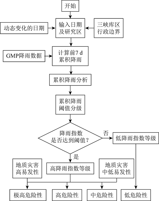
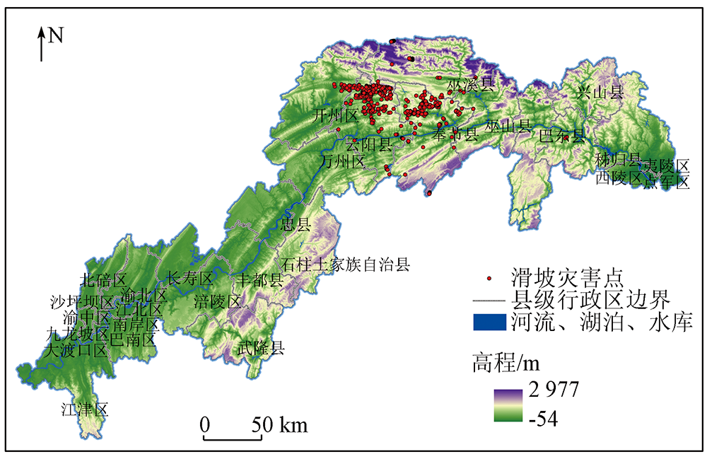
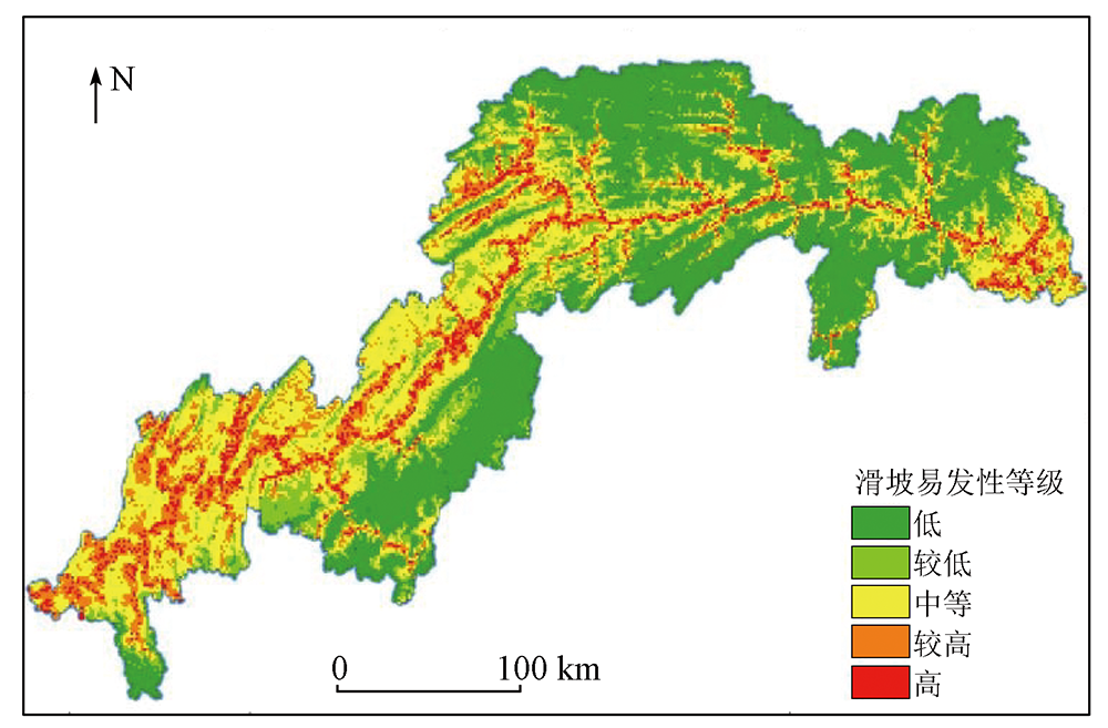
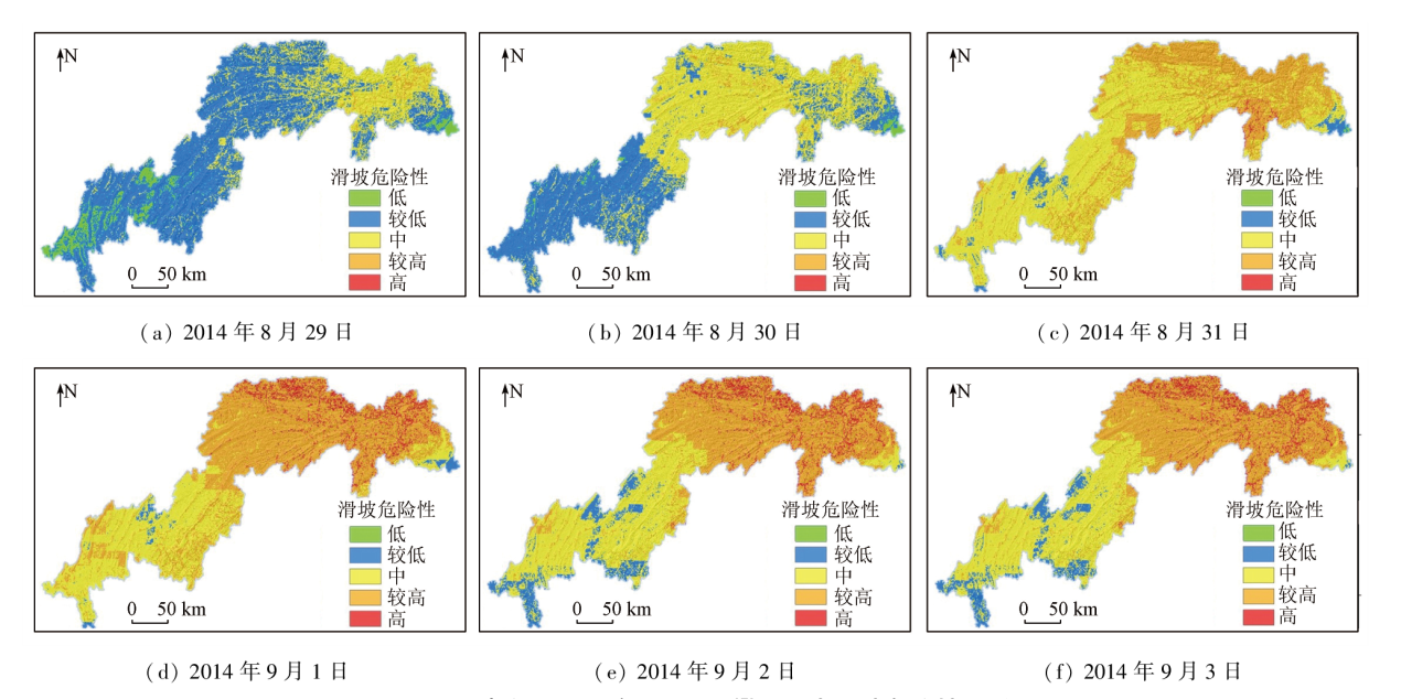
Conventional remote sensing monitoring techniques, constrained by data availability and computational capacity, often fall short of the research requirements of extensive landslide disaster monitoring. This study established a dynamic assessment model for landslide hazards in the Three Gorges Reservoir area based on cloud computing platform Google Earth Engine (GEE), achieving dynamic assessment of landslide hazards in the area under the support of the massive data storage and robust computational capabilities of GEE. First, based on factors such as slope, slope aspect, normalized difference vegetation index (NDVI), normalized differential water index (NDWI), and geological structures, a landslide susceptibility zone map was established using a weighted gradient boosting decision tree (WGBDT) model. Then, the rainfall threshold inducing landslides in the Three Gorges Reservoir area was determined based on the Global Precipitation Measurement (GPM) data from the National Aeronautics and Space Administration (NASA). Subsequently, the rainfall classification criteria and a landslide hazard assessment model were established by combining rainfall and landslide susceptibility. Finally, focusing on the rainfall on August 31 in the Three Gorges Reservoir area, the daily distribution maps of landslide hazards in the Three Gorges Reservoir area were plotted, yielding the spatio-temporal variation trend of landslide hazards. In sum, the data processing and analysis tools of GEE allow for the analysis of landslide-related data of the Three Gorges Reservoir area, thus providing nearly real-time monitoring and early warning information for landslide hazards and offering a basis for the formulation of disaster prevention and mitigation policies.
宋英旭, 邹昱嘉, 叶润青, 贺志霞, 王宁涛. 利用GEE云平台实现三峡库区滑坡危险性动态分析[J]. 自然资源遥感, 2024, 36(1): 154-161.
SONG Yingxu, ZOU Yujia, YE Runqing, HE Zhixia, WANG Ningtao. Dynamic analysis of landslide hazards in the Three Gorges Reservoir area based on Google Earth Engine. Remote Sensing for Natural Resources, 2024, 36(1): 154-161.
Huang R Q. Large-scale landslides and their sliding mechanisms in China since the 20th century[J]. Chinese Journal of Rock Mechanics and Engineering, 2007, 26(3):433-454.
Tang Y, Yin K L, Xia H. Effects of initial water content on the rainfall infiltration and stability of shallow landslide[J]. Geological Science and Technology Information, 2017, 36(5):204-208,237.
[3]
彭令. 三峡库区滑坡灾害风险评估研究[D]. 武汉: 中国地质大学(武汉), 2013.
Peng L. Landslide disaster risk assessment in the Three Gorges reservoir area[D]. Wuhan: China University of Geosciences (Wuhan), 2013.
Zhao P, Yang P L, Jiang L, et al. Situation of geologic hazards induced by heavy rainfall in northeast Chongqing[J]. Journal of Yangtze River Scientific Research Institute, 2017, 34(10):50-56.
Liu Z Z, Song Y X, Ye R Q. An analysis of rainstorm-induced landslides in northeast Chongqing on August 31,2014 based on interpretation of remote sensing images[J]. Remote Sensing of Natural Resources, 2021, 33(4): 192-199.doi:10.6046/zrzyyg.2020348.
[6]
Liu J P, Mason P J, Clerici N, et al. Landslide hazard assessment in the Three Gorges area of the Yangtze River using ASTER imagery[C]// IGARSS 2003.2003 IEEE International Geoscience and Remote Sensing Symposium.Proceedings.Toulouse,France.IEEE, 2004:1302-1304.
[7]
Fourniadis I G, Liu J G, Mason P J. Regional assessment of landslide impact in the Three Gorges area,China,using ASTER data:Wushan-Zigui[J]. Landslides, 2007, 4(3):267-278.
doi: 10.1007/s10346-007-0080-5
[8]
Hong Y, Adler R, Huffman G. Evaluation of the potential of NASA multi-satellite precipitation analysis in global landslide hazard assessment[J]. Geophysical Research Letters, 2006, 33(22):L22402.
[9]
Hong Y, Adler R, Huffman G. Use of satellite remote sensing data in the mapping of global landslide susceptibility[J]. Natural Hazards, 2007, 43(2):245-256.
doi: 10.1007/s11069-006-9104-z
[10]
Kirschbaum D B, Adler R, Hong Y, et al. A global landslide catalog for hazard applications:Method,results,and limitations[J]. Natural Hazards, 2010, 52(3):561-575.
doi: 10.1007/s11069-009-9401-4
[11]
Kirschbaum D, Stanley T. Satellite-based assessment of rainfall-triggered landslide hazard for situational awareness[J]. Earth’s Future, 2018, 6(3):505-523.
doi: 10.1002/eft2.v6.3
[12]
Nadim F, Kjekstad O. Assessment of global high-risk landslide disaster hotspots[M]//Landslides-Disaster Risk Reduction.Berlin: Springer Berlin Heidelberg, 2009:213-221.
[13]
Farahmand A, Aghakouchak A. A satellite-based global landslide model[J]. Natural Hazards and Earth System Sciences, 2013, 13(5):1259-1267.
[14]
Liao Z, Hong Y, Kirschbaum D, et al. Assessment of shallow landslides from Hurricane Mitch in central America using a physically based model[J]. Environmental Earth Sciences, 2012, 66(6):1697-1705.
doi: 10.1007/s12665-011-0997-9
[15]
Kirschbaum D B, Stanley T, Simmons J. A dynamic landslide hazard assessment system for Central America and Hispaniola[J]. Natural Hazards and Earth System Sciences, 2015, 15(10):2257-2272.
[16]
Chen W, Chen Y, Tsangaratos P, et al. Combining evolutionary algorithms and machine learning models in landslide susceptibility assessments[J]. Remote Sensing, 2020, 12(23):3854.
doi: 10.3390/rs12233854
[17]
Tamiminia H, Salehi B, Mahdianpari M, et al. Google Earth Engine for geo-big data applications:A meta-analysis and systematic review[J]. ISPRS Journal of Photogrammetry and Remote Sensing, 2020, 164:152-170.
doi: 10.1016/j.isprsjprs.2020.04.001
[18]
Amani M, Ghorbanian A, Ali Ahmadi S, et al. Google earth engine cloud computing platform for remote sensing big data applications:A comprehensive review[J]. IEEE Journal of Selected Topics in Applied Earth Observations and Remote Sensing, 2020, 13:5326-5350.
doi: 10.1109/JSTARS.4609443
Wang L Y, Chen Q, Wu Y, et al. Accurate recognition and extraction of Karst abandoned land features based on cultivated land parcels and time series NDVI[J]. Remote Sensing for Land and Resources, 2020, 32(3):23-31.doi: 10.6046/gtzyyg.2020.03.04.
Wang B Q, Han W Q, Xu C. Winter wheat planting area identification and extraction based on image segmentation and NDVI time series curve classification model[J]. Remote Sensing for Land and Resources, 2020, 32(2):219-225.doi:10.6046/gtzyyg.2020.02.28.
Xu J X, Fang S B, Zhang T B, et al. NDVI changes and its correlation with climate factors of the Three River-Headwater region in growing seasons during 2000-2016[J]. Remote Sensing for Land and Resources, 2020, 32(1):237-246.doi:10.6046/gtzyyg.2020.01.32.
Wang L, Xie H B, Wen G C, et al. A study on water information extraction method of cyanobacteria lake based on Landsat8[J]. Remote Sensing for Land and Resources, 2020, 32(4):130-136.doi:10.6046/gtzyyg.2019351.
Wang D Z, Wang S M, Huang C. Comparison of Sentinel-2 imagery with Landsat8 imagery for surface water extraction using four common water indexes[J]. Remote Sensing for Land and Resources, 2019, 31(3):157-165.doi:10.6046/gtzyyg.2019.03.20.
Tong L Q, Guo Z C. A study of remote sensing image features of typical landslides[J]. Remote Sensing for Land and Resources, 2013, 25(1):86-92.doi:10.6046/gtzyyg.2013.01.16.
Yang Z Y, Han L Y, Zheng X X, et al. Landslide identification using remote sensing images and DEM based on convolutional neural network:A case study of loess landslide[J]. Remote Sensing for Natural Resources, 2022, 34(2):224-230.doi:10.6046/zrzyyg.2021204.
Jiang P D. Remote sensing technology investigation of geological disasters in Yongfeng County Jiangxi Province[J]. The Chinese Journal of Geological Hazard and Control, 2015, 26(1):82-86, 107.
Jin D J, Zhi X D, Wang J C, et al. Comparison of UAV remote sensing image processing software for geological disasters monitoring[J]. Remote Sensing for Land and Resources, 2016, 28(1):183-189.doi:10.6046/gtzyyg.2016.01.27.
Zhao Y X, Jin Z X, Ma Y X. Remote sensing investigation in geological disasters investigation method and technique requirements-a case study of geological disasters investigation in Yanchi County of Ningxia[J]. Ningxia Engineering Technology, 2014, 13(3):196-200.
[29]
徐潇宇. 三峡库区地质灾害防治系统运行机制研究[D]. 中国地质大学, 2013.
Xu X Y. Research on the operation mechanism of the system dealing with the prevention and control of geological hazards in three gorges reservoir area[D]. Wuhan: China University of Geosciences, 2013.
[30]
Zhang H, Song Y, Xu S, et al. Combining a class-weighted algorithm and machine learning models in landslide susceptibility mapping:A case study of Wanzhou section of the Three Gorges Reservoir,China[J]. Computers & Geosciences, 2022, 158:104966.
doi: 10.1016/j.cageo.2021.104966
 2024, Vol. 36
  ), 邹昱嘉2, 叶润青3, 贺志霞1, 王宁涛3(