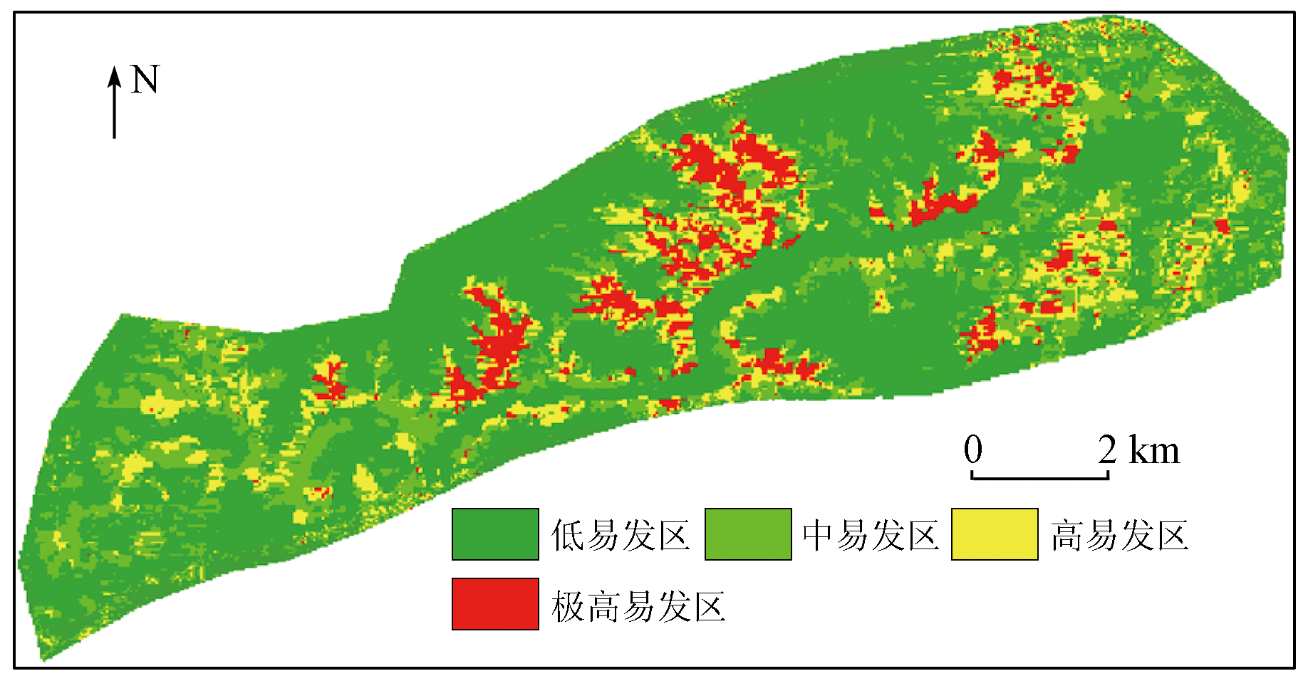
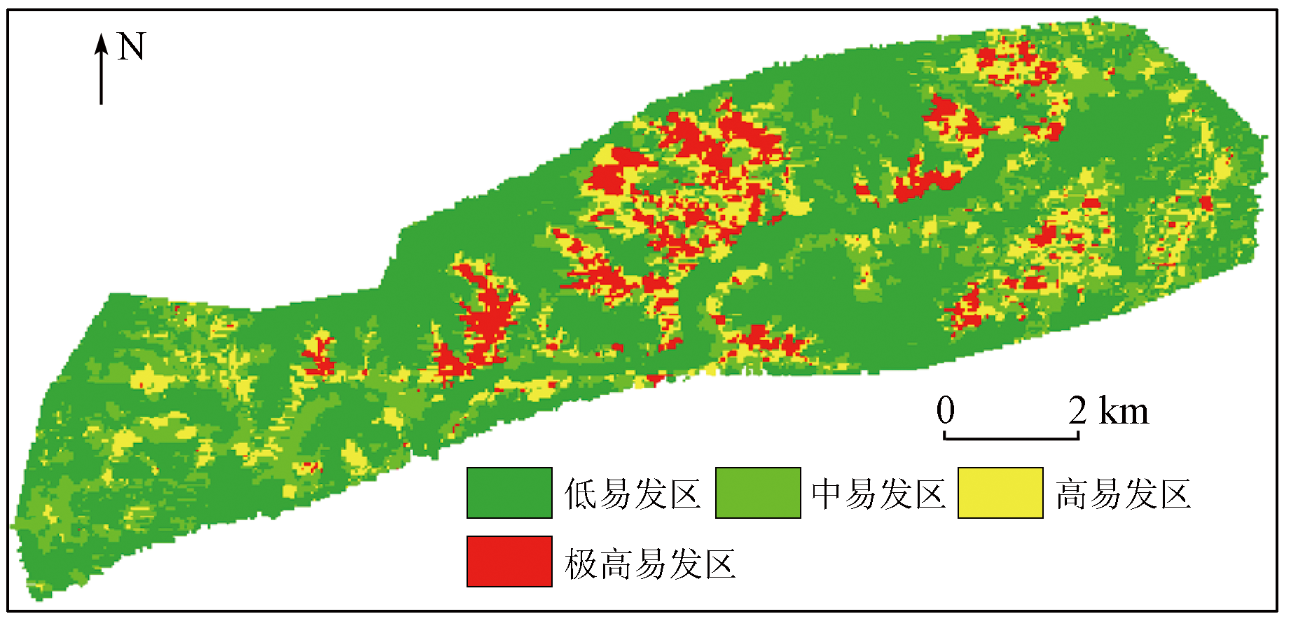
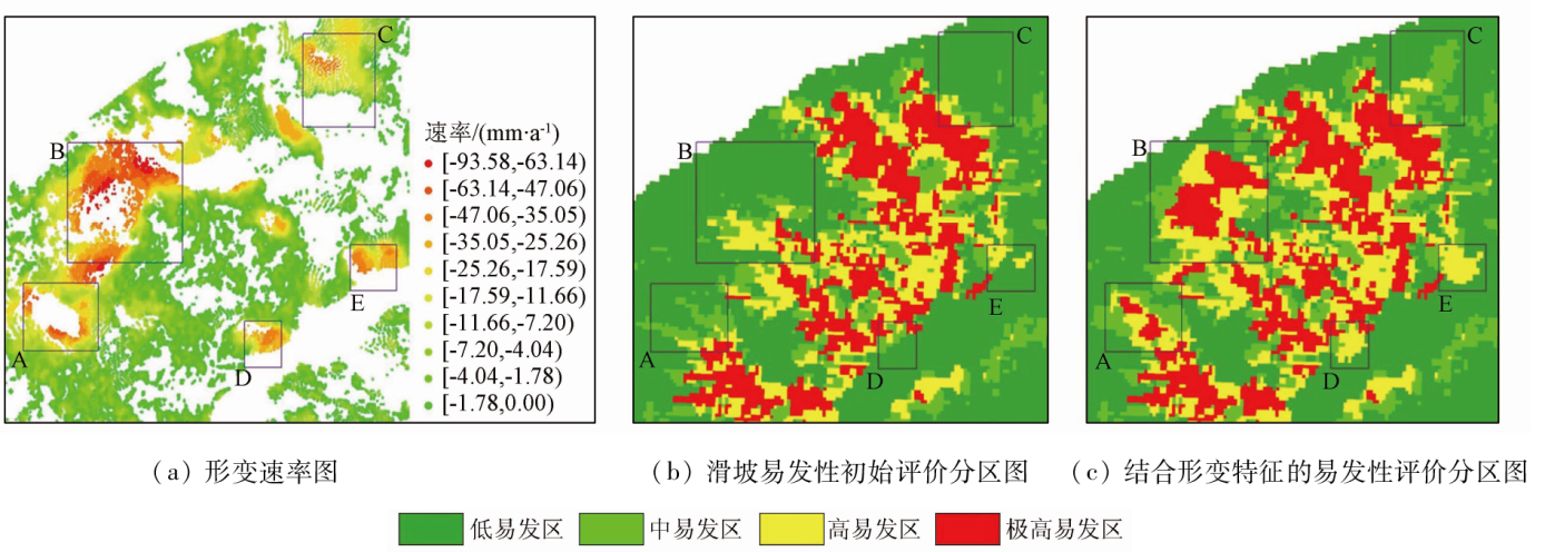
Assessing the landslide susceptibility of highways in precarious mountainous areas can provide crucial information for the geologic route selection of highways. Conventional landslide susceptibility assessment methods ignore the application of surface deformation data and other dynamic data, leading to low-accuracy assessment results. Hence, this study proposed a landslide susceptibility assessment method for mountain highways based on optical and SAR remote sensing images. With the Longwuxia-Gongboxia section of the Yanhuang Highway in Qinghai Province as the study area, this study extracted various static factors of landslides from high-resolution QuickBird satellite images and calculated the initial risk level of landslide susceptibility within the route area using a random forest model. Afterward, this study obtained the surface deformation factors, which directly reflect the dynamic changes of landslides, based on the long-time-series Sentinel-1A images. Finally, this study corrected the initial landslide susceptibility risk level based on the surface deformation factors, generating a landslide susceptibility assessment zoning map. As demonstrated by engineering practice, the method proposed in this study yielded a high-accuracy landslide susceptibility assessment zoning map for the mountain highway by combining data on both static and dynamic factors of landslides, thus providing accurate information for subsequent geologic route selection of the highway.
余绍淮, 徐乔, 余飞. 联合光学和SAR遥感影像的山区公路滑坡易发性评价方法[J]. 自然资源遥感, 2023, 35(4): 81-89.
YU Shaohuai, XU Qiao, YU Fei. Method for assessing landslide susceptibility of highways in mountainous areas based on optical and SAR remote sensing images. Remote Sensing for Natural Resources, 2023, 35(4): 81-89.
Li W J, Shao H. Landslide susceptibility assessment based on multi-scale segmentation of remote sensing and geological factor eValuation[J]. The Chinese Journal of Geological Hazard and Control, 2021, 32(2):94-99.
Huang H F, Xue R H, Zhao B B, et al. The bedding rock landslide identification in the head area of the Three Gorges Reservoir combined with disaster pregnant mechanism and comprehensive remote sensing method[J]. Acta Geodaetica et Cartographica Sinica, 2022, 51(10):2056-2068.
doi: 10.11947/j.AGCS.2022.20220306
Jia W J, Wang Z H. Landslide activity characteristics and stability analysis based on high-resolution remote sensing image:A case study of Dongmiaojia landslide[J]. Remote Sensing for Land and Resources, 2019, 31(4):174-181.
[4]
Youssef A M, Pourghasemi H R. Landslide susceptibility mapping using machine learning algorithms and comparison of their performance at Abha Basin,Asir Region,Saudi Arabia[J]. Geoscience Frontiers, 2021, 12(2):639-655.
doi: 10.1016/j.gsf.2020.05.010
Hu Z Y, Luo W Q, Yan E C, et al. IAHP-based evaluation of susceptibility of geological hazards in Yingshan County[J]. Safety and Environmental Engineering, 2018, 25(4):28-32.
[6]
刘阳. 延长县滑坡地质灾害风险评估和管理研究[D]. 西安: 长安大学, 2009.
Liu Y. The extention of geologal disasters of landslide risk assessment and management research in the Yanchang County[D]. Xi’an: Changan University, 2009.
[7]
Hong H, Chen W, Xu C, et al. Rainfall-induced landslide susceptibility assessment at the Chongren area (China) using frequency ratio,certainty factor,and index of entropy[J]. Geocarto International, 2017, 32(2):139-154.
Zhou X T, Huang F M, Wu W C, et al. Regional landslide susceptibility prediction based on negative sample selected by coupling information value method[J]. Advanced Engineering Sciences, 2022, 54(3):25-35.
Liu Y, Wang N T, Zhou C, et al. Evaluation of landslide susceptibility based on ROC and certainty factor method in Fengjie County,Three Gorges Reservoir[J]. Safety and Environmental Engineering, 2020, 27(4):61-70.
Yang Z Y, Han L Y, Zheng X X, et al. Landslide identification using remote sensing images and DEM based on convolutional neural network:A case study of loess landslide[J]. Remote Sensing for Natural Resources, 2022, 34(2):224-230.doi:10.6046/zrzyyg.2021204.
Liu J P, Liang E J, Xu S H, et al. Multi-kernel support vector machine considering sample optimization selection for analysis and evaluation of landslide disaster susceptibility[J]. Acta Geodaetica et Cartographica Sinica, 2022, 51(10):2034-2045.
doi: 10.11947/j.AGCS.2022.20220326
Wu R Z, Hu X D, Mei H B, et al. Spatial susceptibility assessment of landslides based on random forest: A case study from Hubei section in the Three Gorges Reservoir area[J]. Earth Science, 2021, 46(1):321-330.
Xu Q, Yu F, Yu S H. Landslide hazard assessment of mountain railways based on multi-source remote sensing data[J]. Journal of Railway Engineering Society, 2021, 38(11):8-14.
Wang W D, He Z L, Han Z, et al. Landslides susceptibility assessment based on deep belief network[J]. Journal of Northeastern University( Natural Science), 2020, 41(5):609-615.
Yu S H, Xu Q, Luo B R. Application of time series InSAR technology in remote sensing geological survey of mountainous highway[J]. Highway, 2021, 66(10):251-257.
Zhao F M, Zhang Y, Meng X M, et al. Early identification of geological hazards in the Gaizi valley near the Karakoran Highway based on SBAS-InSAR technology[J]. Hydrogeology & Engineering Geology, 2020, 47(1):142-152.
Zhang T, Xie S, Huang B, et al. Detection of active landslides in central Maoxian County using Sentinel-1 and ALOS-2 data[J]. Remote Sensing for Land and Resources, 2021, 33(2):213-219.doi:10.6046/gtzyyg.2020206.
Zhu Y. Landslide susceptibility assessment of Dafang and Nayong County of Guizhou Province combining with PS-InSAR[D]. Beijing: China University of Geosciences(Beijing), 2020.
Yang Q. Research on landslide susceptibility based on time series InSAR technology in PiLi Qing River Basin[D]. Chengdu: Chengdu University of Technology, 2019.
Xu Q, Zhang X, Yu S H, et al. Multi-feature-based classification method using random forest and superpixels for polarimetric SAR images[J]. Journal of Remote Sensing, 2019, 23(4):685-694.
Liu M X, Liu J H, Ma M F, et al. Monitoring of Zanthoxylum bungeanum Maxim planting using GF-2 PMS images and the random forest algorithm:A case study of Linxia,Gansu Province[J]. Remote Sensing for Natural Resources, 2022, 34(1):218-229.doi:10.6046/zrzyyg.2021112.
[22]
Ferretti A, Prati C, Rocca F, et al. Permanent scatters in SAR Interferometry[J]. IEEE Transactions on Geoscience and Remote Sensing, 2001, 39(1):8-20.
doi: 10.1109/36.898661
[23]
Berardino P, Fornaro G, Lanari R, et al. A new algorithm for surface deformation monitoring based on small baseline differential SAR interferograms[J]. IEEE Transactions on Geoscience and Remote Sensing, 2002, 40(11):2375-2383.
doi: 10.1109/TGRS.2002.803792
Zhang S J, Jiang J J, Miao Y M, et al. Application of the SBAS technique in potential landslide identification in the Minjiang watershed[J]. Mountain Research, 2018, 36(1):91-97.
[25]
Herrera G, Gutiérrez F, García-Davalillo J C, et al. Multi-sensor advanced DInSAR monitoring of very slow landslides:The Tena Valley case study (Central Spanish Pyrenees)[J]. Remote Sensing of Environment, 2013, 128:31-43.
doi: 10.1016/j.rse.2012.09.020
Zhang Q K, Ling S X, Li X N, et al. Comparison of landslide susceptibility mapping rapid assessment models in Jiuzhaigou County,Sichuan Province,China[J]. Chinese Journal of Rock Mechanics and Engineering, 2020, 39(8):1595-1610.
 2023, Vol. 35
  ), 徐乔(