Predicting surface subsidence in large-scale mining areas based on time-series InSAR and the IRIME-LSTM model
CEHN Lanlan1(), FAN Yongchao2, XIAO Haiping3(), WAN Junhui3, CHEN Lei3
1. School of Resources and Civil Engineering, Gannan University of Science and Technology, Ganzhou 341000, China 2. Jiangxi Piaotang Tungsten Industry Co., Ltd., Ganzhou 341500, China 3. School of Civil Engineering and Surveying and Mapping Engineering, Jiangxi University of Science and Technology, Ganzhou 341000, China
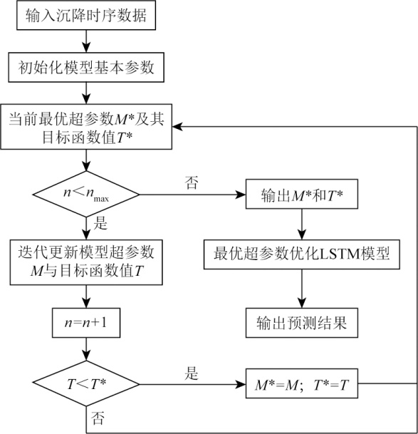
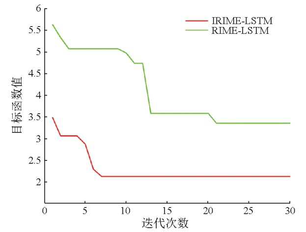
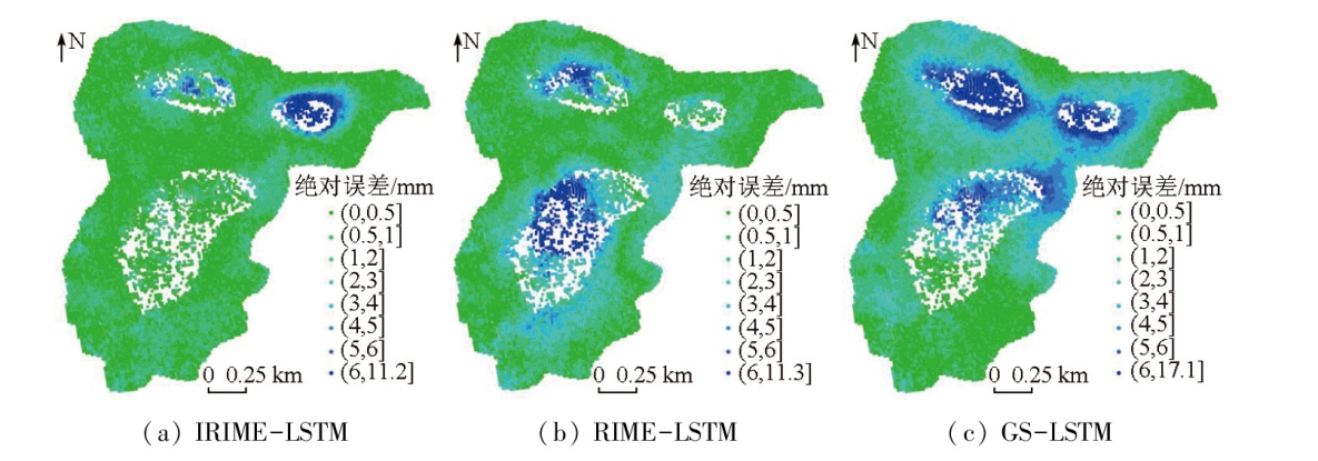
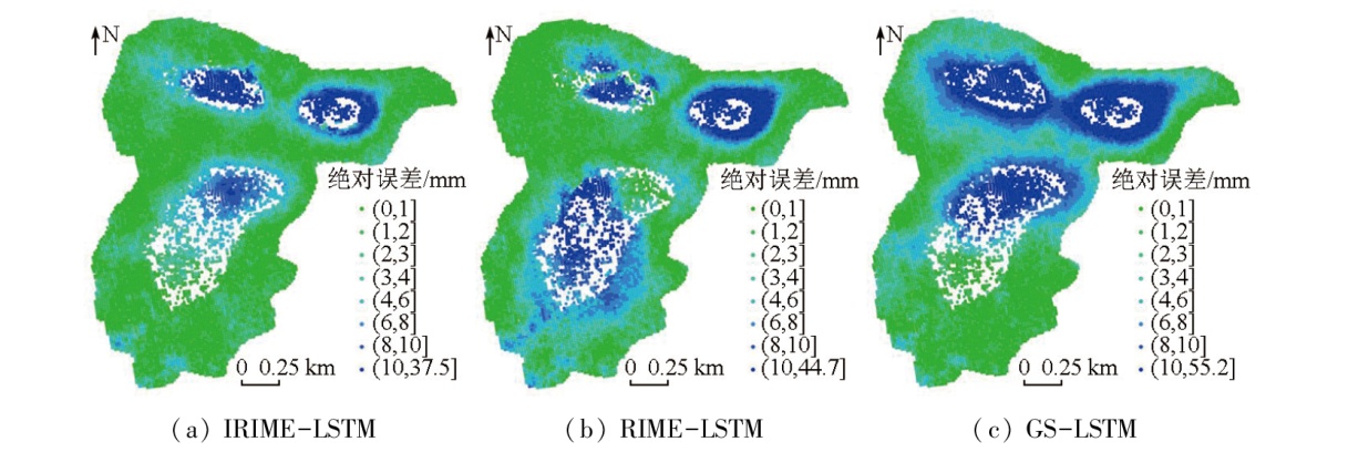
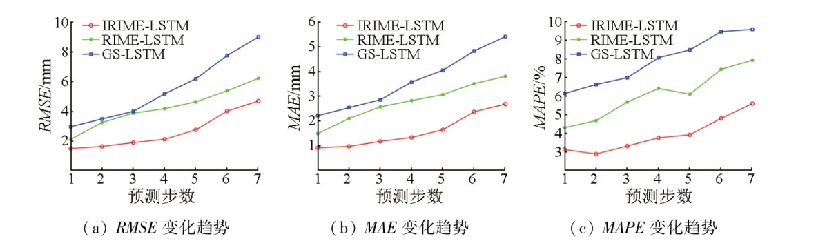
Interferometric synthetic aperture Radar (InSAR) technology serves as a significant approach for analyzing surface subsidence in large-scale mining areas. Accurately predicting surface subsidence plays a significant role in preventing geological disasters. The long short-term memory (LSTM) network model faces challenges in parameter selection, while the rime optimization algorithm (RIME) is susceptible to local optimum and dependence on the initial solution. Considering these challenges, this study proposed a surface subsidence prediction model with LSTM optimized by the improved rime optimization algorithm (IRIME). The IRIME incorporated chaotic mapping, the improved Lévy flight mechanism, and the global exploration strategy of the hunter-prey optimizer (HPO). The proposed model is also referred to as the IRIME-LSTM model. With the Honghui coal mine as the study area, this study obtained the subsidence time series of highly coherent points in the mining area using small baseline subset (SBAS)-InSAR technology. Subsequently, this study conducted multi-step predictions of these highly coherent points using the IRIME-LSTM model, with the prediction results compared with the InSAR monitoring data. The results of this study indicate that the IRIME-LSTM model yielded a root mean square error (RMSE) of 2.65 mm, a mean absolute error (MAE) of 1.59 mm, and a mean absolute percentage error (MAPE) of 3.92 % in the overall test set. Compared to the RIME-LSTM and GS-LSTM models, the IRIME-LSTM model reduced the RMSE by 37.20 % and 51.73 %, the MAE by 42.60 % and 56.32 %, and the MAPE by 35.63 % and 50.51 %, respectively, demonstrating its high reliability and feasibility.
陈兰兰, 范永超, 肖海平, 万俊辉, 陈磊. 结合时序InSAR与IRIME-LSTM模型的大范围矿区地表沉降预测[J]. 自然资源遥感, 2025, 37(3): 245-252.
CEHN Lanlan, FAN Yongchao, XIAO Haiping, WAN Junhui, CHEN Lei. Predicting surface subsidence in large-scale mining areas based on time-series InSAR and the IRIME-LSTM model. Remote Sensing for Natural Resources, 2025, 37(3): 245-252.
Li X, Jiao Y Y, Zou J P, et al. Study on overlying strata movement and ground subsidence in deep coal mining[J]. Safety and Environmental Engineering, 2022, 29(2):32-38,56.
Dun Z L, Wang W C, Zou Y F, et al. Dynamic prediction of surface subsidence and calculation of residual deformation in goaf based on time function combination model[J]. Journal of China Coal Society, 2022, 47(s1):13-28.
Xu Z X, Ji M, Zhang G, et al. Method for dynamic prediction of mining subsidence based on the SBAS-InSAR technology and the logistic model[J]. Remote Sensing for Natural Resources, 2022, 34(2):20-29.doi:10.6046/zrzyyg.2021354.
Tan Z X, Yang J W, Deng K Z. Study on method of mining subsi-dence parameters calculating for whole basin of mining area based on SBAS-InSAR[J]. Coal Science and Technology, 2021, 49(1):312-318.
Yang W, He Y, Zhang L F, et al. InSAR monitoring of 3D surface deformation in Jinchuan mining area,Gansu Province[J]. Remote Sensing for Natural Resources, 2022, 34(1):177-188.doi:10.6046/zrzyyg.2021107.
[6]
Riyas M J, Syed T H, Kumar H, et al. Detecting and analyzing the evolution of subsidence due to coal fires in Jharia coalfield,India using sentinel-1 SAR data[J]. Remote Sensing, 2021, 13(8):1521.
Ma Y Y, Chen Y B, Zuo X Q, et al. Analysis of land subsidence in Kunming based on Sentinel-1A data and SBAS technology[J]. Science of Surveying and Mapping, 2019, 44(11):59-66,95.
[8]
Ding Y K, Liu R, Fan Y F, et al. Monitoring glaciers in the Chenab Basin with SBAS InSAR technology[J]. Journal of Mountain Science, 2022, 19(9):2622-2633.
Yang F, Hu J, Sun C X. Prediction of range surface subsidence based on InSAR technology and deep learning[J]. Science of Surveying and Mapping, 2022, 47(7):60-68,134.
Liu Q H, Zhang Y H, Deng M, et al. Time series prediction method of large-scale surface subsidence based on deep learning[J]. Acta Geodaetica et Cartographica Sinica, 2021, 50(3):396-404.
doi: 10.11947/j.AGCS.2021.20200038
Zhou W T, Zhang W J, Yang Y J, et al. A combined model prediction method for surface subsidence monitoring in mining areas[J]. Journal of Geodesy and Geodynamics, 2021, 41(3):308-312.
Yue Z H, Shen T, Mao X, et al. Study on prediction method of land subsidence based on recurrent neural network[J]. Science of Surveying and Mapping, 2020, 45(12):145-152.
Shi Y, Li J, Lyv J, et al. Monitoring and prediction of mining subsidence based on SBAS-InSAR and improved support vector regression[J]. Remote Sensing Information, 2021, 36(2):6-12.
Yan T, Chen B, Cao E H, et al. Prediction of dam deformation using EEMD-ELM model[J]. Journal of Yangtze River Scientific Research Institute, 2020, 37(11):70-73,80.
doi: 10.11988/ckyyb.20190892
[15]
Su H, Zhao D, Heidari A A, et al. RIME:A physics-based optimization[J]. Neurocomputing, 2023,532:183-214.
[16]
Wang X, Li J, Shao L, et al. Short-term wind power prediction by an extreme learning machine based on an improved hunter-prey optimization algorithm[J]. Sustainability, 2023, 15(2):991.
Ge C, Qian S Q. Path planning of unmanned vehicle based on improved sparrow search algorithm[J]. Journal of Navigation and Positioning, 2022, 10(6):107-111.
Liu H, Xu X Y, Chen M, et al. Time-series InSAR-based dynamic remote sensing monitoring of the Great Wall of the Ming Dynasty in Qinhuangdao[J]. Remote Sensing for Natural Resources, 2023, 35(2):202-211.doi:10.6046/zrzyyg.2021163.
Xiao H P, Xia Y Q, Liu X S, et al. Prediction method of surface subsidence in mining area by the integration of SBAS-InSAR technique and TSO-LSTM model[J]. Metal Mine, 2023(1):126-133.
Liu Q H, Liu H M, Zhang Y H, et al. A spatio-temporal prediction method of large-scale ground subsidence considering spatial hete-rogeneity[J]. National Remote Sensing Bulletin, 2022, 26(7):1315-1325.
Liu B B, Yang J J, Tao L, et al. Study on prediction of educational statistical data based on DE-LSTM model[J]. Computer Science, 2022, 49(s1):261-266.
 2025, Vol. 37
  ), 范永超2, 肖海平3(