|
|
 |
|

|
|
|
3D city model construction based on a consumer-grade UAV |
Zhongdi YU1,2( ), Hui LI1(), Fang BA1, Zhaoyang WANG1 ), Hui LI1(), Fang BA1, Zhaoyang WANG1 |
1. School of Earth Sciences, China University of Geosciences, Wuhan 430074, China
2. Beijing North-star Digital Remote Sensing Technology Co., Ltd., Beijing 100120, China |
|
|
|
|
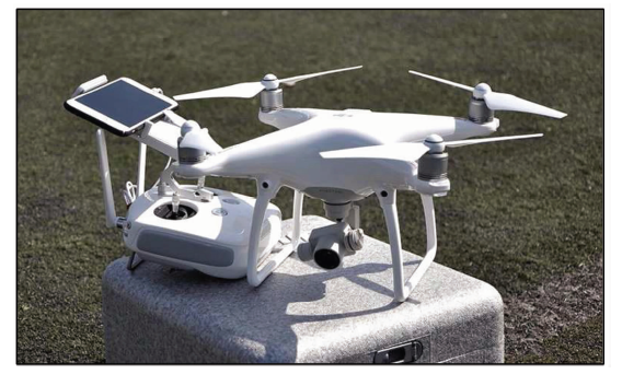
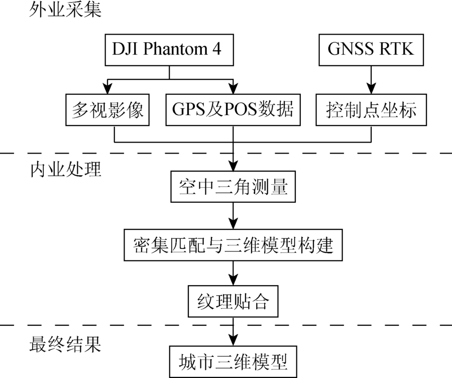
Abstract 3D modeling of urban buildings is one of the key technologies for smart city construction. The traditional modeling methods have many disadvantages in the process of data collection, such as operating difficulty, high cost and low efficiency in 3D modeling. In this paper, the authors propose a 3D city modeling approach based on oblique photography technology of unmanned aerial vehicle(UAV) for consumption. The cradle is used to control the direction of lens, and multi-angle slanted images are obtained. Then the 3D model is constructed by using aerial triangulation principle, and textures of building walls are extracted from multi-angle images. Finally the texture is mapped to the corresponding models, and the true 3D model is built. Result shows that the approach can not only improve modeling efficiency but also reduce the cost during data producing process.
|
| Keywords
consumer-grade UAV
oblique photogrammetry
3D model
|
|
|
|
Corresponding Authors:
Hui LI
E-mail: 1786399629@qq.com;leelmars@gmail.com
|
|
Issue Date: 30 May 2018
|
|
|
| [1] |
万宝林 . 3DS MAX与SketchUp的三维城市建模技术实验对比分析[J]. 测绘地理信息, 2015,40(2):23-25.
doi: 10.14188/j.2095-6045.2015.02.006
url: http://d.wanfangdata.com.cn/Periodical/chxxygc201502006
|
| [1] |
Wan B L . Comparative analysis of urban geospatial 3D modeling technology between 3DS MAX and SketchUp[J]. Journal of Geomatics, 2015,40(2):23-25.
|
| [2] |
谭金石, 吴云辉, 范海生 , 等. 基于ArcGIS与航空影像的城市三维建模方法研究[J]. 测绘地理信息, 2014. 39(6):59-61.
doi: 10.14188/j.2095-6045.2014.06.017
url: http://d.wanfangdata.com.cn/Periodical/chxxygc201406017
|
| [2] |
Tan J S, Wu Y H, Fan H S , et al. Research on city 3D modeling based on ArcGIS and aerial images[J]. Journal of Geomatics, 2014,39(6):59-61.
|
| [3] |
吴静, 靳奉祥, 王建 . 基于三维激光扫描数据的建筑物三维建模[J]. 测绘工程, 2007,16(5):57-60.
doi: 10.3969/j.issn.1006-7949.2007.05.015
url: http://d.wanfangdata.com.cn/Periodical/chgc200705015
|
| [3] |
Wu J, Jin F X, Wang J . Three dimension modeling of buildings based on three dimension laser scanner data[J]. Engineering of Surveying and Mapping, 2007,16(5):57-60.
|
| [4] |
张春森, 张卫龙, 郭丙轩 , 等. 倾斜影像的三维纹理快速重建[J]. 测绘学报, 2015,44(7):782-790.
doi: 10.11947/j.AGCS.2015.20140341
url: http://www.cqvip.com/QK/90069X/201507/665481442.html
|
| [4] |
Zhang C S, Zhang W L, Guo B X , et al. Rapidly 3D texture reconstruction based on oblique photography[J]. Acta Geodaetica et Cartographica Sinica, 2015,44(7):782-790.
|
| [5] |
李安福, 曾政祥, 吴晓明 . 浅析国内倾斜摄影技术的发展[J]. 测绘与空间地理信息, 2014,37(9):57-62.
doi: 10.3969/j.issn.1672-5867.2014.09.017
url: http://www.cqvip.com/QK/98140A/201409/662218448.html
|
| [5] |
Li A F, Zeng Z X, Wu X M . The analysis of the development of oblique photography technique in China[J]. Geomatics and Spatial Information Technology, 2014,37(9):57-62.
|
| [6] |
曲林, 张淑娟, 冯洋 , 等. 倾斜摄影测量高中低空解决方案研究[J]. 测绘与空间地理信息, 2016,39(1):19-23.
doi: 10.3969/j.issn.1672-5867.2016.01.006
url: http://d.wanfangdata.com.cn/Periodical/dbch201601006
|
| [6] |
Qu L, Zhang S J, Feng Y , et al. Study on photogrammetry solutions based on high-middle-low level[J]. Geomatics and Spatial Information Technology, 2016,39(1):19-23.
|
| [7] |
毕凯, 李英成, 丁晓波 , 等. 轻小型无人机航摄技术现状及发展趋势[J].测绘通报, 2015(3):27-31,48.
doi: 10.13474/j.cnki.11-2246.2015.0068
url: http://www.cqvip.com/QK/93318X/201503/67728466504849534851484856.html
|
| [7] |
Bi K, Li Y C, Ding X B , et al. Aerial photogrammetric technology of light small UAV:Status and trend of development[J].Bulletin of Surveying and Mapping, 2015(3):27-31,48.
|
| [8] |
魏占玉, Ramon A, 何宏林,等.基于SfM方法的高密度点云数据生成及精度分析[J]. 地震地质, 2016,37(2):636-648.
doi: 10.3969/j.issn.0253-4967.2015.02.024
url: http://d.wanfangdata.com.cn/Periodical/dzdz201502024
|
| [8] |
Wei Z Y, Ramon A, He H L , et al. Accuracy analysis of terrain point cloud acquired by“structure from motion”using aerial photos[J]. Seismology and Geology, 2016,37(2):636-648.
|
| [9] |
曲林, 冯洋, 支玲美 , 等. 基于无人机倾斜摄影数据的实景三维建模研究[J]. 测绘与空间地理信息, 2015,38(3):38-39,43.
doi: 10.3969/j.issn.1672-5867.2015.03.013
url: http://www.cqvip.com/QK/98140B/201503/664154153.html
|
| [9] |
Qu L, Feng Y, Zhi L M , et al. Study on real 3D modeling of photographic data based on UAV[J]. Geomatics and Spatial Information Technology, 2015,38(3):38-39,43.
|
| [10] |
何豫航, 岳俊 . 基于CMVS/PMVS多视角密集匹配方法的研究与实现[J]. 测绘地理信息, 2013,38(3):20-23.
url: http://www.cqvip.com/QK/93326B/201303/46001064.html
|
| [10] |
He Y H, Yue J . Research and implementation based on multi-view dense matching by applying CMVS/PMVS[J]. Journal of Geomatics, 2013,38(3):20-23.
|
| [11] |
刘彬, 陈向宁, 郭连朋 . 分块立体重建的PMVS算法研究与实现[J]. 测绘科学技术学报, 2014,31(6):614-619.
|
| [11] |
Liu B, Chen X N, Guo L P . Research and implementation of PMVS algorithm based on block dimensional reconstruction[J]. Journal of Geomatics Science and Technology, 2014,31(6):614-619.
|
| [12] |
国家测绘地理信息局测绘标准化研究所, 国家测绘地理信息局第一航测遥感院, 国家测绘地理信息局第三航测遥感院. GB/T 23236—2009 数字航空摄影测量空中三角测量规范[S].北京: 中国标准出版社, 2009.
|
| [12] |
Institute of Standardization of Surveying and Mapping of the State Bureau of Surveying and Mapping, the First Institute of Aero-Photogrammery and Remote Sensing,NASG,the Third Institute of Aero-Photogrammery and Remote Sensing,NASG. GB/T 23236—2009 specifications for aerotriangulation of digital aerophotogrammetry[S].Beijing: China Standards Publishing House, 2009.
|
| [13] |
国家测绘地理信息局. CH/T 9015—2012 三维地理信息模型数据产品规范[S].北京: 中国测绘出版社, 2013.
|
| [13] |
National Administration of Surveying,Mapping and Geoinformation. CH/T 9015—2012 specifications for the dgital products of three-dimensional model on geographic information[S].Beijing: China Standards Publishing House, 2013.
|
|
Viewed |
|
|
|
Full text
|
|
|
|
|
Abstract
|
|
|
|
|
Cited |
|
|
|
|
| |
Shared |
|
|
|
|
| |
Discussed |
|
|
|
|
 2018,
Vol. 30
2018,
Vol. 30