|
|
 |
|

|
|
|
Study and application of sequential extraction method of ground fissures based on object |
Xinghang ZHANG1,2, Lin ZHU1,2( ), Wei WANG3, Lishan MENG3, Xiaojuan LI1,2, Yingchao REN4 ), Wei WANG3, Lishan MENG3, Xiaojuan LI1,2, Yingchao REN4 |
1.College of Resource Environment and Tourism, Capital Normal University, Beijing 100048, China
2.Laboratory Cultivation Base of Environment Process and Digital Simulation, Beijing 100048, China
3.Laboratory of Non-fossil Energy Minerals,Tianjin Center of China Geological Survey, Tianjin 300170, China
4.The State Key Laboratory of Remote Sensing Science, Institute of Remote Sensing and Digital Earth, Chinese Academy of Sciences, Beijing 100101, China |
|
|
|
|
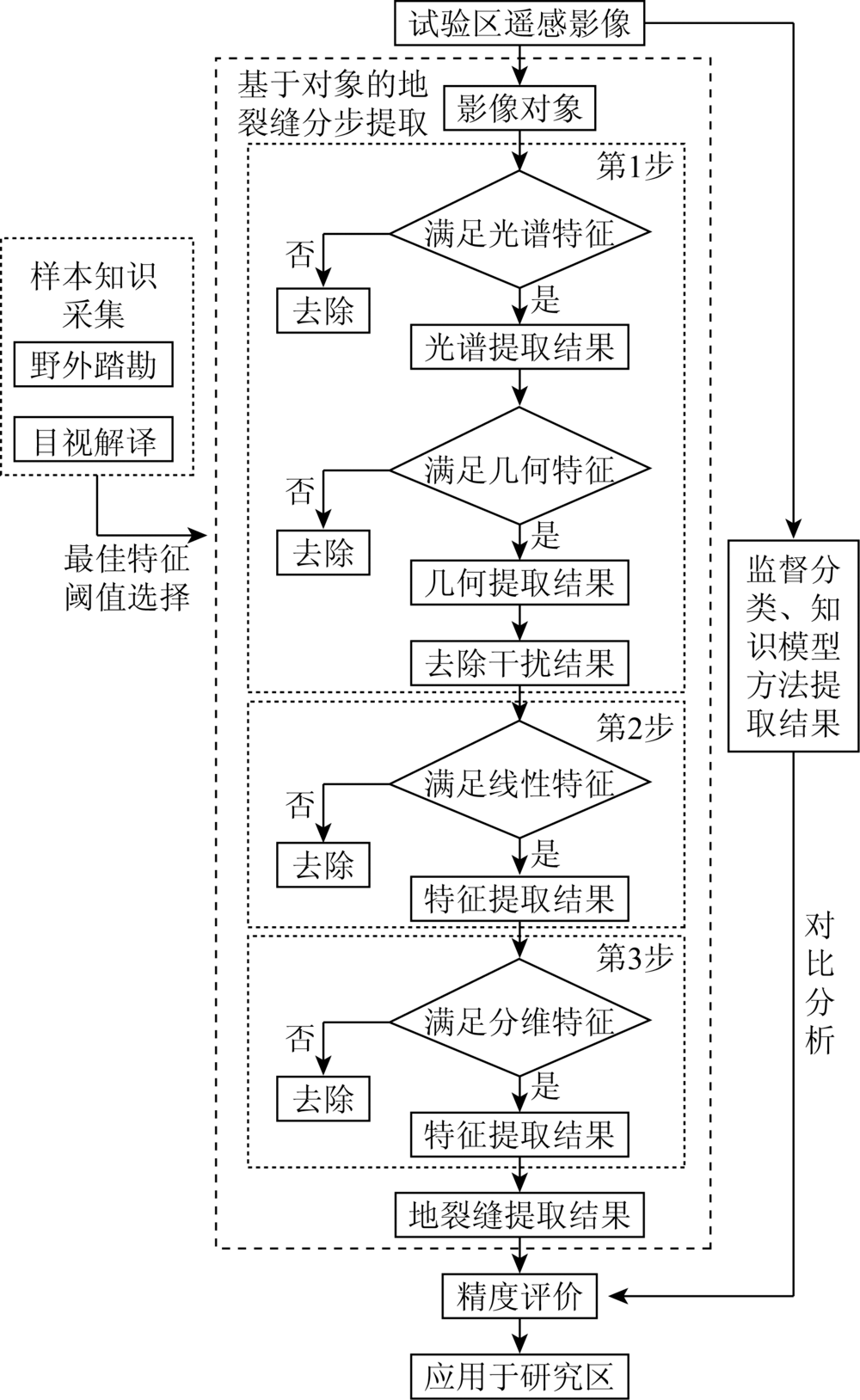
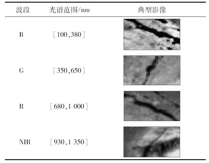
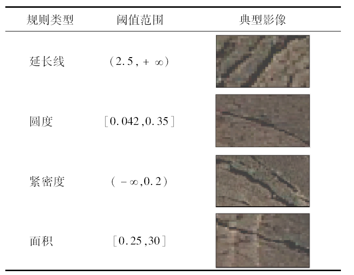
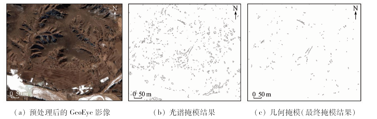
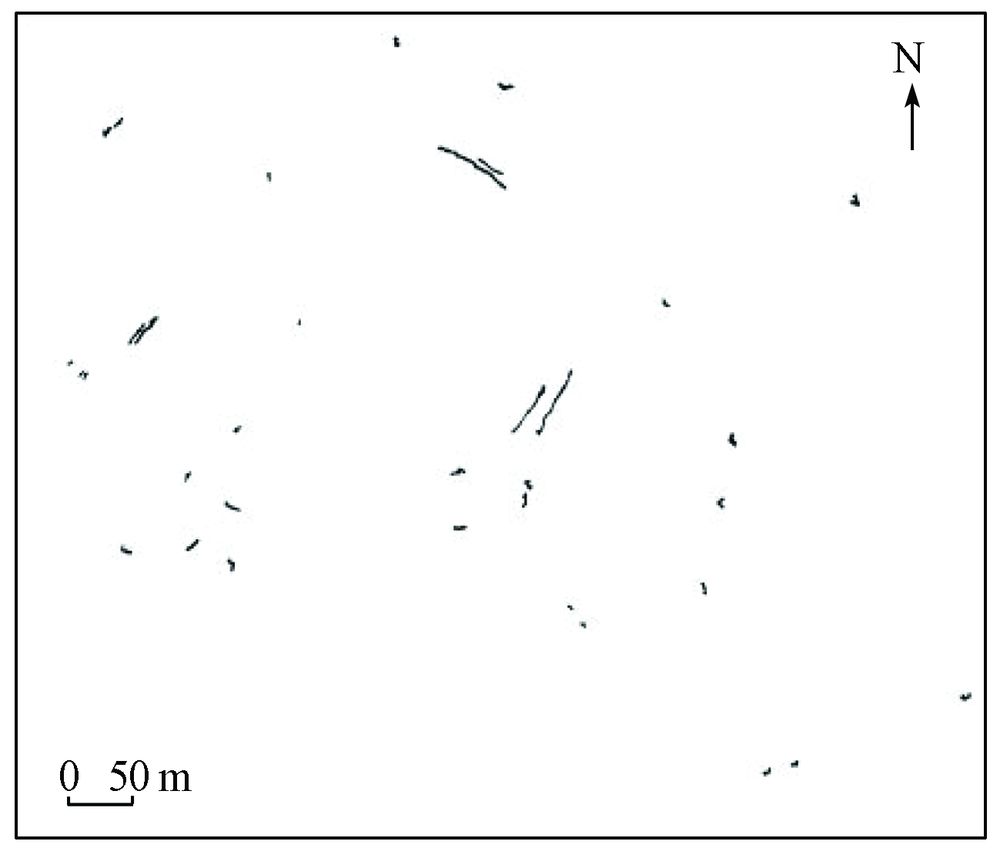
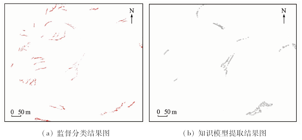
Abstract The automatic extraction technology of regional scale ground fissures based on remote sensing images has the problem of low spectral range and low geometric feature, which leads to low extraction precision. Therefore, the sequential step extraction method for ground fissures based on objects is proposed. Firstly, the image is segmented. According to the spectral and geometric characteristics of segmentation object, surface interference factors which are different from the ground fissures are removed by mask. On such a basis, the linear objects are extracted and the surface factors without linear features are removed ultimately. Finally, the fractal characteristics of linear objects are calculated to differentiate between the ground fissures and other linear surface factors and complete the automatic extraction of ground fissures. The method was applied to the extraction of ground fissures in a coal-mining region of northeastern Ordos. The results show that the method is effective in extracting the ground fissures. Its accuracy reaches 85.7%, which is better than the precision of traditional supervised classification method (57.1%) and the precision of knowledge model extraction method (71.4%) . On the basis of extraction results, this paper discusses the distribution characteristics of ground fissures. The respective relations between ground fissures and the location of goafs as well as topography are analyzed. The results show that the number of ground fissures is negatively correlated to the distance of goafs and is not clearly correlated to the topography. The research can provide the necessary technical support for the regional geological environment protection and the rational exploitation of coal resources in the mining area.
|
| Keywords
GeoEye image
ground fissures
sequential extraction
feature extraction
|
|
|
|
Corresponding Authors:
Lin ZHU
E-mail: zhulin@163.com
|
|
Issue Date: 15 March 2019
|
|
|
| [1] |
符继卫 . 矿区采空塌陷与地裂缝灾害探析[J]. 山西焦煤科技, 2011,35(7):46-48.
doi: 10.3969/j.issn.1672-0652.2011.07.013
url: http://d.wanfangdata.com.cn/Periodical/sxjmkj201107013
|
| [1] |
Fu J W . Discussion on mining subsidence and ground fissures[J]. Shanxi Coking Coal Science and Technology, 2011,35(7):46-48.
|
| [2] |
Xu L Q, Li S Z, Cao X Z , et al. Holocene intracontinental deformation of the northern North China Plain:Evidence of tectonic ground fissures[J]. Journal of Asian Earth Sciences, 2016,119(9):49-64.
doi: 10.1016/j.jseaes.2016.01.003
url: https://linkinghub.elsevier.com/retrieve/pii/S1367912016300037
|
| [3] |
Peng J B, Qiao J W, Leng Y Q , et al. Distribution and mechanism of the ground fissures in Wei River Basin,the origin of the Silk Road[J]. Environmental Earth Sciences, 2016,75(8):718.
doi: 10.1007/s12665-016-5527-3
url: http://link.springer.com/10.1007/s12665-016-5527-3
|
| [4] |
赵炜 . 基于GIS、RS技术的陕北煤炭开发区地裂缝信息的自动提取[D]. 西安:长安大学, 2009.
|
| [4] |
Zhao W . Based on the GIS and RS Technology of Remote Sensing of Cracks in the Coal Mining Area in North Shaanxi[D]. Xi’an:Chang’an University, 2009.
|
| [5] |
王娅娟, 孟淑英, 李军 , 等. 地裂缝信息遥感提取方法研究[J]. 神华科技, 2011,9(5):31-33,39.
doi: 10.3969/j.issn.1674-8492.2011.05.010
url: http://www.cnki.com.cn/Article/CJFDTotal-SBMT201105011.htm
|
| [5] |
Wang Y J, Meng S Y ,Li J. et al.Study on remote sensing extraction of cracks information[J]. Shen Hua Science and Technology, 2011,9(5):31-33,39.
|
| [6] |
魏长婧, 汪云甲, 王坚 , 等. 无人机影像提取矿区地裂缝信息技术研究[J]. 金属矿山, 2012,41(10):90-92,96.
doi: 10.3969/j.issn.1001-1250.2012.10.024
url: http://www.cqvip.com/QK/90084X/201210/43851154.html
|
| [6] |
Wei C J, Wang Y J ,Wang J. et al.The technical research of extracting ground fissure information in mining area with the UAV image[J]. Metal Mine, 2012,41(10):90-92,96.
|
| [7] |
Wang Y J, Tian F, Huang Y , et al. Monitoring coal fires in Datong coalfield using multi-source remote sensing data[J]. Transactions of Nonferrous Metals Society of China, 2015,25(10):3421-3428.
doi: 10.1016/S1003-6326(15)63977-2
url: https://linkinghub.elsevier.com/retrieve/pii/S1003632615639772
|
| [8] |
肖春蕾, 郭兆成, 张宗贵 , 等. 利用机载LiDAR数据提取与分析地裂缝[J].国土资源遥感, 2014(4):111-118.doi: 10.6046/gtzyyg.2014.04.18.
doi: 10.6046/gtzyyg.2014.04.18
url: http://www.cqvip.com/QK/91397X/201404/663060372.html
|
| [8] |
Xiao C L, Guo Z C, Zhang Z G , et al. Extraction and analysis of ground fissures from airborne LiDAR data[J]. Remote Sensing for Land and Resources, 2014,26(4):111-118.doi: 10.6046/gtzyyg.2014.04.18.
|
| [9] |
Gruen A, Li H . Semi-automatic linear feature extraction by dynamic programming and LSB-Snakes[J]. Photogrammetric Engineering and Remote Sensing, 1997,63(8):985-995.
|
| [10] |
李朝锋 . 遥感图像智能处理[M]. 北京: 电子工业出版社, 2007.
|
| [10] |
Li Z F. Intelligent Processing of Remote Sensing Images[M]. Beijing: Pubshing House of Electronics Industry, 2007.
|
| [11] |
Peng J B, Sun X H, Wang W , et al. Characteristics of land subsidence,earth fissures and related disaster chain effects with respect to urban hazards in Xi’an,China[J]. Environmental Earth Sciences, 2016,75(16):1190.
doi: 10.1007/s12665-016-5928-3
url: http://link.springer.com/10.1007/s12665-016-5928-3
|
| [12] |
张正健, 李爱农, 雷光斌 , 等. 基于多尺度分割和决策树算法的山区遥感影像变化检测方法——以四川攀西地区为例[J]. 生态学报, 2014,34(24):7222-7232.
doi: 10.5846/stxb201310112439
|
| [12] |
Zhang Z J, Li A N, Lei G B , et al. Change detection of remote sensing images based on multiscale segmentation and decision tree algorithm over mountainous area:A case study in Panxi region,Sichuan Province[J]. Acta Ecologica Sinica, 2014,34(24):7222-7232.
|
| [13] |
鲁恒, 付萧, 李龙国 , 等. 最优分割尺度支持下高分遥感影像水土资源信息分类[J]. 农业机械学报, 2016,47(9):327-333.
doi: 10.6041/j.issn.1000-1298.2016.09.044
url: http://www.cnki.com.cn/Article/CJFDTotal-NYJX201609044.htm
|
| [13] |
Lu H, Fu X, Li L G , et al. Soil and water resources information classification in high resolution images with optimal segmentation scale[J]. Transactions of the Chinese Society for Agricultural Machinery, 2016,47(9):327-333.
|
| [14] |
宫兆宁, 赵雅莉, 赵文吉 , 等. 基于光谱指数的植物叶片叶绿素含量的估算模型[J]. 生态学报, 2014,34(20):5736-5745.
doi: 10.5846/stxb201301250160
url: http://www.cqvip.com/QK/90772X/201420/662700980.html
|
| [14] |
Gong Z N, Zhao Y L, Zhao W J , et al. Estimation model for plant leaf chlorophyll content based on the spectral index content[J]. Acta Ecologica Sinic, 2014,34(20):5736-5745.
|
| [15] |
王今飞 . 遥感卫星图像中线性地质特征的自动提取[J]. 第四纪研究, 2000,20(3):252-258.
doi: 10.3321/j.issn:1001-7410.2000.03.006
url: http://www.cnki.com.cn/Article/CJFDTotal-DSJJ200003006.htm
|
| [15] |
Wang J F . Automated geologic lineament detection from satellite remote sensing imagery[J]. Quaternary Sciences, 2000,20(3):252-258.
|
| [16] |
吴俐民, 於雪琴, 黄亮 . FCM聚类算法协同Canny算子的遥感影像边缘检测方法[J]. 测绘工程, 2014,23(12):1-4.
doi: 10.3969/j.issn.1006-7949.2014.12.001
url: http://www.cnki.com.cn/Article/CJFDTotal-CHGC201412001.htm
|
| [16] |
Wu L M, Yu X Q, Huang L . Edge detection method of remote sensing images based on FCM clustering algorithm and canny operator. Engineering of Surveying and Mapping, 2014,23(12):1-4.
|
| [17] |
孙少林, 马志强, 汤伟 . 灰度图像二值化算法研究[J]. 价值工程, 2010,29(5):142-143.
doi: 10.3969/j.issn.1006-4311.2010.05.080
url: http://d.wanfangdata.com.cn/Periodical/jzgc201005080
|
| [17] |
Sun S L, Ma Z Q, Tang W . Research on gray-level image binarization algorithms[J]. Value Engineering, 2010,29(5):142-143.
|
| [18] |
Mandelbrot B B . The fractal geometry of nature[J]. The Quarterly Review of Biology, 1983,58(3):412-413.
doi: 10.1119/1.13295
url: http://www.ams.org/mathscinet-getitem?mr=665254
|
| [19] |
宋晓夏, 唐跃刚, 李伟 , 等. 中梁山南矿构造煤吸附孔分形特征[J]. 煤炭学报, 2013,38(1):134-139.
doi:
url: http://d.wanfangdata.com.cn/Periodical/mtxb201301022
|
| [19] |
Song X X, Tang Y G, Li W , et al. Fractal characteristics of adsorption pores of tectonic coal from Zhongliangshan southern coalmine[J]. Journal of China Coal Society, 2013,38(1):134-139.
|
|
Viewed |
|
|
|
Full text
|
|
|
|
|
Abstract
|
|
|
|
|
Cited |
|
|
|
|
| |
Shared |
|
|
|
|
| |
Discussed |
|
|
|
|
 2019,
Vol. 31
2019,
Vol. 31