|
|
 |
|

|
|
|
Cloud detection based on support vector machine with image features for GF-1 data |
LI Xusheng1( ), LIU Yufeng2(), CHEN Donghua2,3, LIU Saisai4, LI Hu2,3 ), LIU Yufeng2(), CHEN Donghua2,3, LIU Saisai4, LI Hu2,3 |
1. College of Grass Industry and Environment, Xinjiang Agricultural University, Urumqi 830052, China
2. College of Computer and Information Engineering, Chuzhou University, Chuzhou 239000, China
3. College of Geography and Tourism, Anhui Normal University, Wuhu 241000, China
4. College of Geography and Tourism, Xinjiang Normal University, Urumqi 830001, China |
|
|
|
|
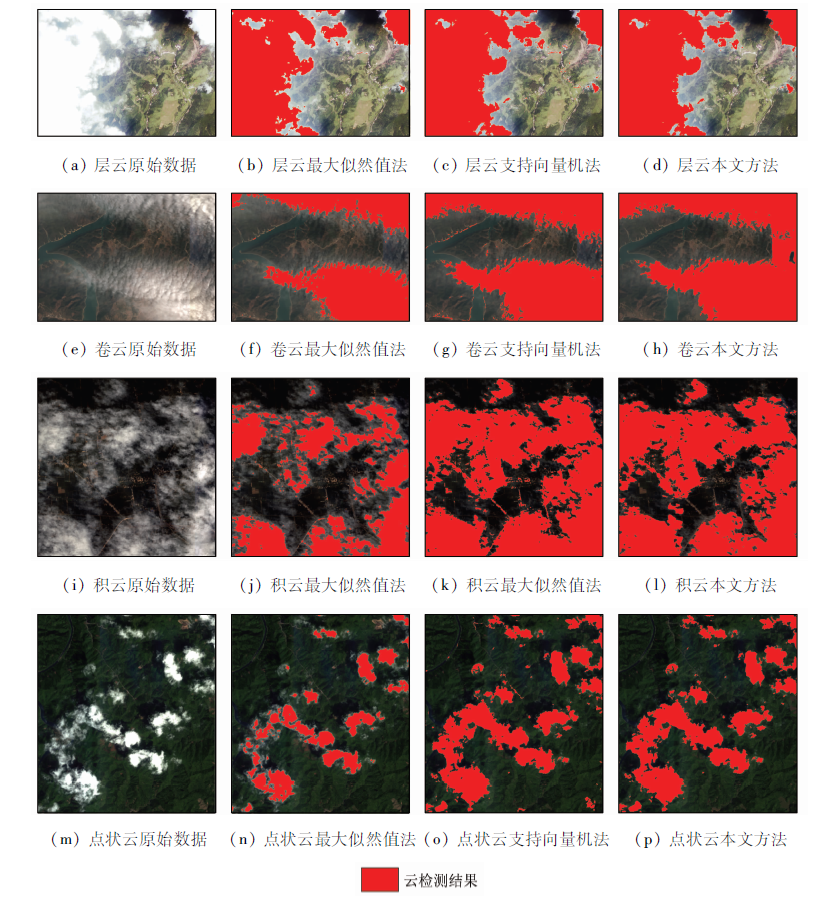
Abstract In the GF-1 image data applications, applying cloud layers influences accuracy of information extraction and image utilization rate, to tackling this problem, this paper proposes a support vector machine cloud detection method combining image spectral features and texture features. For GF-1 data, the method of the gray-level co-occurrence matrix is used to extract those texture features. Spectral characteristics of clouds and ground and texture characteristics serve as feature vector, and support vector machine (SVM) is used to conduct cloud detection to GF-1 data. Studies have shown that the precision and recall of this method for all kinds of cloud detection are above 99.2% and 93.9%, and the error rate is below 1.1%, which is obviously better than the cloud detection algorithm using traditional support vector machine and maximum likelihood value, and it combines the image texture and spectral characteristics, and thus it has certain universality in theory.
|
| Keywords
cloud detection
support vector machine
feature extraction
GF-1
|
|
|
|
Corresponding Authors:
LIU Yufeng
E-mail: saintlxs@foxmail.com;liuyufeng941@163.com
|
|
Issue Date: 09 October 2020
|
|
|
| [1] |
刘紫涵, 吴艳兰. 遥感图像云检测方法研究进展[J]. 国土资源遥感, 2017,29(4):6-12.doi: 10.6046/gtzyyg.2017.04.02.
|
| [1] |
Liu Z H, Wu Y L. A review of cloud detection methods in remote sensing images[J]. Remote Sensing for Land and Resources, 2017,29(4):6-12.doi: 10.6046/gtzyyg.2017.04.02.
|
| [2] |
陈曦东, 张肖, 刘良云, 等. 增强型多时相云检测[J]. 遥感学报, 2019,23(2):280-290.
|
| [2] |
Chen X D, Zhang X, Liu L Y, et al. Enhanced multi-temporal cloud detection algorithm for optical remote sensing images[J]. Journal of Remote Sensing, 2019,23(2):280-290.
|
| [3] |
王奎, 张荣, 尹东, 等. 基于边缘特征和AdaBoost分类的遥感影像云检测[J]. 遥感技术与应用, 2013,28(2):263-268.
url: http://www.rsta.ac.cn/CN/abstract/abstract2237.shtml
|
| [3] |
Wang K, Zhang R, Yin D, et al. Cloud detection for remote sensing image based on edge features and AdaBoost classifier[J]. Remote Sensing Technology and Application, 2013,28(2):263-268.
url: http://www.rsta.ac.cn/CN/abstract/abstract2237.shtml
|
| [4] |
Wilson M J, Oreopoulos L. Enhancing a simple MODIS cloud mask algorithm for the Landsat data continuity mission[J]. IEEE Transactions on Geoscience and Remote Sensing, 2013,51(2):723-731.
doi: 10.1109/TGRS.2012.2203823
url: http://dx.doi.org/10.1109/TGRS.2012.2203823
|
| [5] |
丁海燕, 马灵玲, 李子扬, 等. 基于分形维数的全色影像云雪自动识别方法[J]. 遥感技术与应用, 2013,28(1):52-57.
url: http://www.rsta.ac.cn/CN/abstract/abstract2206.shtml
|
| [5] |
Ding H Y, Ma L L, Li Z Y, et al. Automatic identification of cloud and snow based on fractal dimension[J]. Remote Sensing Technology and Application, 2013,28(1):52-57.
url: http://www.rsta.ac.cn/CN/abstract/abstract2206.shtml
|
| [6] |
Hughes M, Daniel H. Automated detection of cloud and cloud shadow in single-date Landsat imagery using neural networks and spatial post-processing[J]. Remote Sensing, 2014,6(6):4907-4926.
doi: 10.3390/rs6064907
url: http://www.mdpi.com/2072-4292/6/6/4907
|
| [7] |
Ricciardelli E, Romano F, Cuomo V. Physical and statistical approaches for cloud identification usingmeteosat second generation-spinning enhanced visible and infrared imager data[J]. Remote Sensing of Environment, 2008,112(6):2741-2760.
doi: 10.1016/j.rse.2008.01.015
url: https://linkinghub.elsevier.com/retrieve/pii/S0034425708000424
|
| [8] |
陈前, 吴俣, 叶菁菁, 等. 面向城市区域的遥感影像云检测方法[J]. 遥感信息, 2018,33(5):57-61.
|
| [8] |
Chen Q, Wu Y, Ye J J, et al. Cloud detection method for remote sensing image in urban area[J]. Remote Sensing Information, 2018,33(5):57-61.
|
| [9] |
云雅, 夏勇, 张锦水, 等. 采用单时相法的高分一号数据云/阴影检测[J]. 遥感信息, 2017,32(4):35-40.
|
| [9] |
Yun Y, Xia Y, Zhang J S, et al. Cloud and cloud shadow detection in GF-1 imagery using single-date method[J]. Remote Sensing Information, 2017,32(4):35-40.
|
| [10] |
陈振炜, 张过, 宁津生, 等. 资源三号测绘卫星自动云检测[J]. 测绘学报, 2015,44(3):292-300.
doi: 10.11947/j.AGCS.2015.20130384
url: http://xb.sinomaps.com:8081/Jwk_chxb/CN/abstract/abstract6502.shtml
|
| [10] |
Chen Z W, Zhang G, Ning J S, et al. An automatic cloud detection method for ZY-3 satellite[J]. Acta Geodaetica et Cartographica Sinica, 2015,44(3):292-300.
doi: 10.11947/j.AGCS.2015.20130384
url: http://xb.sinomaps.com:8081/Jwk_chxb/CN/abstract/abstract6502.shtml
|
| [11] |
徐启恒, 黄滢冰, 陈洋. 结合超像素和卷积神经网络的国产高分辨率遥感影像云检测方法[J].测绘通报, 2019(1):50-55.
|
| [11] |
Xu Q H, Huang Y B, Chen Y. Cloud detection for Chinese high resolution remote sensing imagery using combining superpixel with convolution neural network[J].Bulletin of Surveying and Mapping 2019(1):50-55.
|
| [12] |
Irish R R, Barker J L, Goward S N, et al. Characterization of the Landsat-7 ETM+ automated cloud-cover assessment (ACCA) algorithm[J]. Photogrammetric Engineering and Remote Sensing, 2006,72(10):1179-1188.
doi: 10.14358/PERS.72.10.1179
url: http://openurl.ingenta.com/content/xref?genre=article&issn=0099-1112&volume=72&issue=10&spage=1179
|
| [13] |
Zhu Z, Woodcock C E. Object-based cloud and cloud shadow detection in Landsat imagery[J]. Remote Sensing of Environment, 2012,118(6):83-94.
doi: 10.1016/j.rse.2011.10.028
url: https://linkinghub.elsevier.com/retrieve/pii/S0034425711003853
|
| [14] |
Clausi D A, Deng H. Design-based texture feature fusion using Gabor filters and co-occurrence probabilities[J]. IEEE Transactions on Image Processing, 2005,14(7):925-936.
pmid: 16028556
url: https://www.ncbi.nlm.nih.gov/pubmed/16028556
|
| [15] |
Cortes C, Vapnik V. Support-vector networks[J]. Machine Learning, 1995,20(3):273-297.
|
| [16] |
Cristianini N, Shawe-Taylo J. An introduction to support vector machines and other kernel-based learning methods[M]. Cambridge,U.K.:Cambridge Univ.Press, 2000: 9-22.
|
|
Viewed |
|
|
|
Full text
|
|
|
|
|
Abstract
|
|
|
|
|
Cited |
|
|
|
|
| |
Shared |
|
|
|
|
| |
Discussed |
|
|
|
|
 2020,
Vol. 32
2020,
Vol. 32