|
|
|
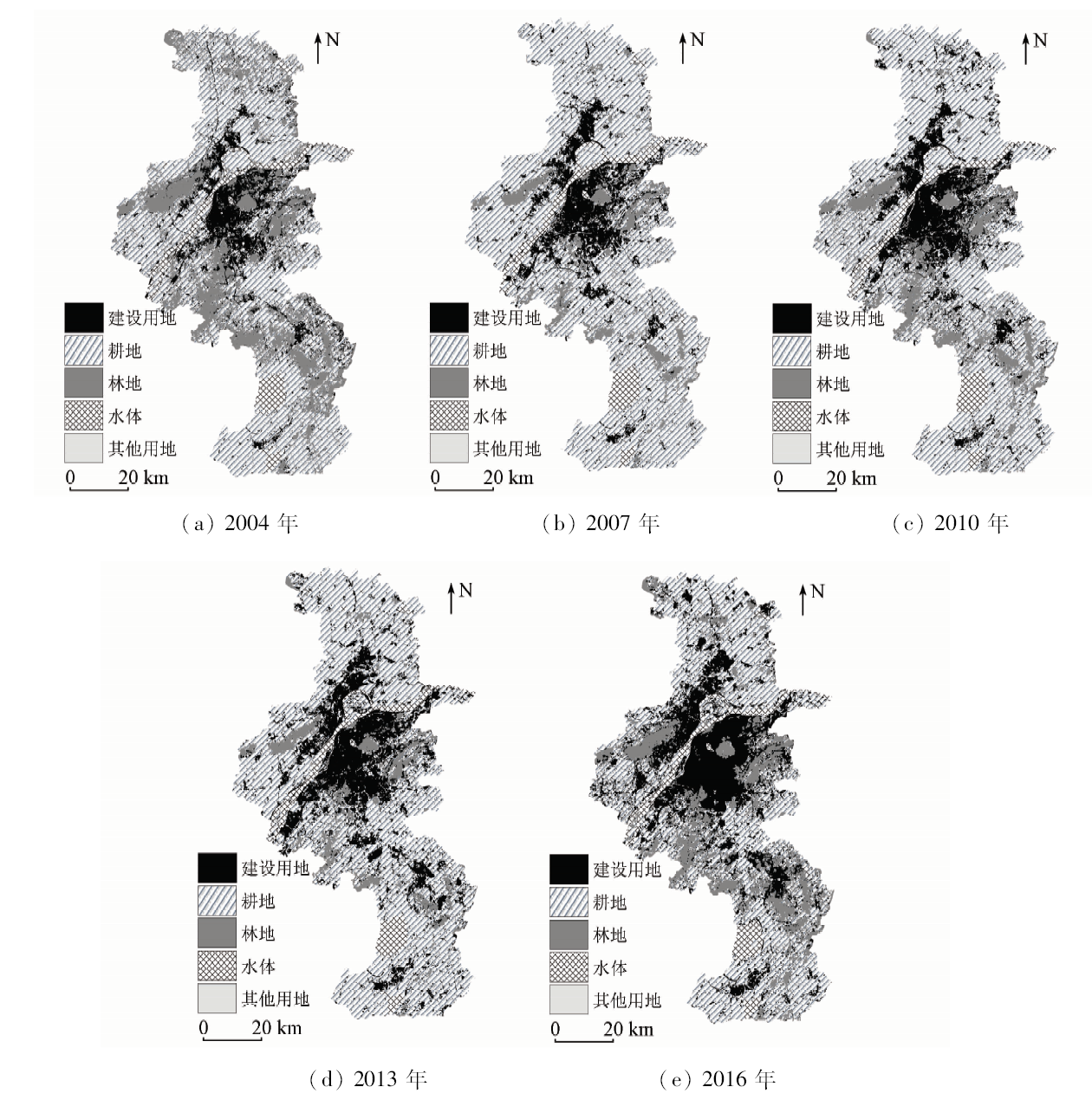
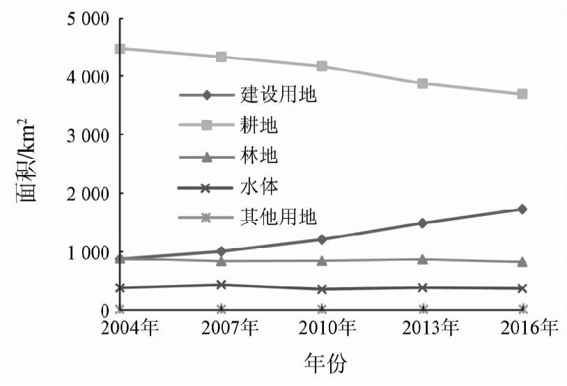
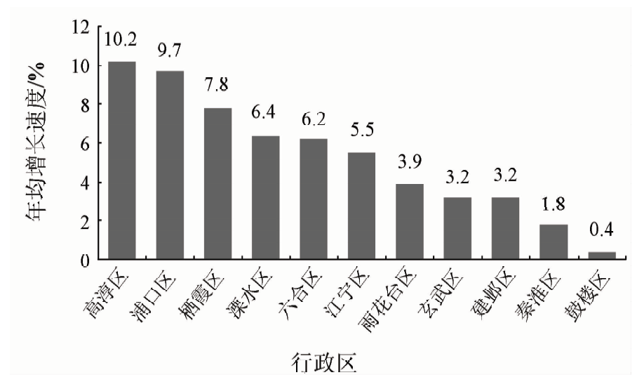
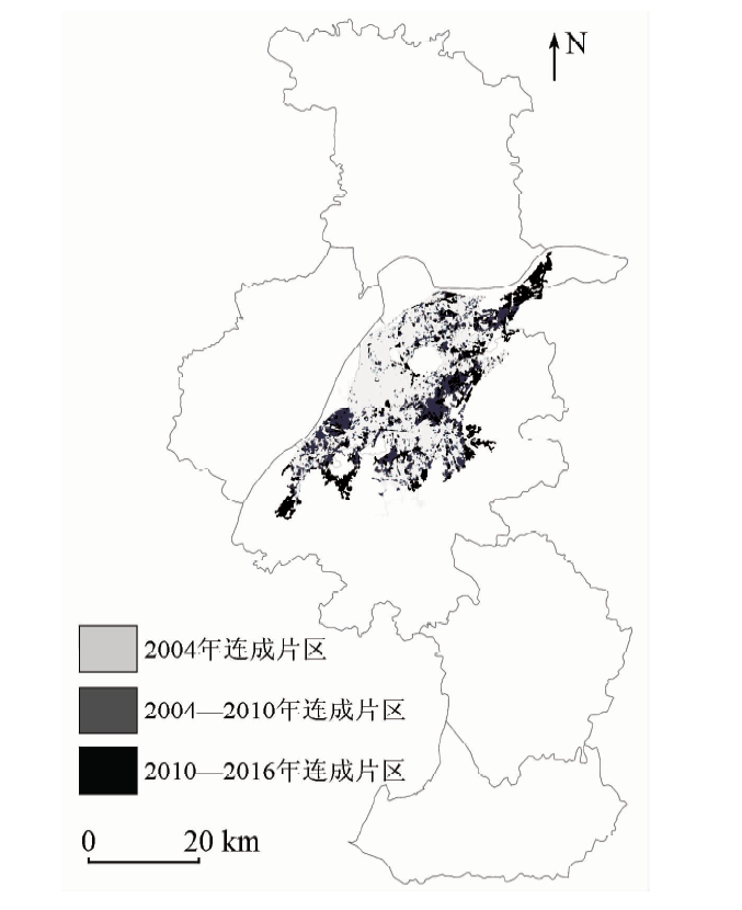
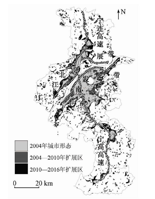
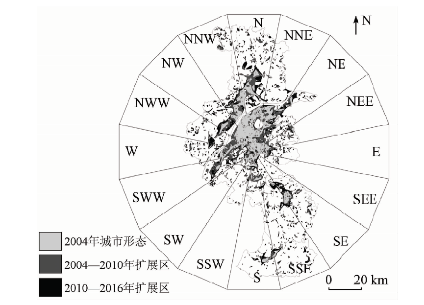
Abstract This study is based on five Landsat TM remote sensing images obtained in Nanjing City in 2004, 2007, 2010, 2013 and 2016 respectively. With landscape index method, fans analysis method and some other spatial analysis methods, the expansion characteristics of Nanjing City and its evolution were analyzed quantitatively, which revealed urban expansion in Nanjing City and morphological evolution feature in time and space. The results show that, during the period of 2004—2016, the construction land expansion of Nanjing City was mainly realized through occupying large areas of cultivated, and the speed of city expansion was faster than population growth, which was not conducive to the sustainable development of Nanjing City structure. In the growth of the construction of the city area, city expansion rate increases year by year, city expansion first strong expands and then the expansion tends to slow down, regional differences of city space growth are significant. The internal structure of Nanjing City tends to be stable, the external contour tends to be compacted, and urban area expansion is weakened. Expansion mode is mainly along the river, Nanjing City gradually forms urban spatial structure, exhibiting the pattern of the “two belts and one axis”, and is in a multi center development trend. Urban expansion in Nanjing City forms a non-differential balanced state space, and the city expansion is mainly concentrated in the north, southwest and southeast of of Nanjing, and shows obvious characteristics of various stages.
|
| Keywords
urban expansion
morphological evolution
Nanjing City
|
|
|
|
Corresponding Authors:
Haiyue FU
E-mail: fuhaiyue@njau.edu.cn
|
|
Issue Date: 23 May 2019
|
|
|
| [1] |
刘盛和, 吴传钧, 沈洪泉 . 基于GIS的北京城市土地利用扩展模式[J]. 地理学报, 2000,55(4):407-416.
|
| [1] |
Liu S H, Wu C J, Shen H Q . A GIS based model of urban land use growth in Beijing[J]. Acta Geographica Sinica, 2000,55(4):407-416.
|
| [2] |
牛方曲, 刘卫东, 宋涛 , 等. 城市群多层次空间结构分析算法及其应用——以京津冀城市群为例[J]. 地理研究, 2015,34(8):1447-1460.
|
| [2] |
Niu F Q, Liu W D, Song T , et al. A multi-level spatial structure analysis algorithmn for urban agglomeration study in China[J]. Geo-graphical Research, 2015,34(8):1447-1460.
|
| [3] |
吝涛, 李新虎, 张国钦 , 等. 厦门岛城市空间扩张特征及其影响因素分析[J]. 地理学报, 2010,65(6):715-726.
|
| [3] |
Lin T, Li X H, Zhang G Q , et al. Dynamic analysis of island urban spatial expansion and its determinants:A case study of Xiamen Island[J]. Acta Geographica Sinica, 2010,65(6):715-726.
|
| [4] |
Angel S, Parent J, Civco D. Urban sprawl metrics:An analysis of global urban expansion using GIS [C]//ASPRS Annual Conference.Florida, 2007.
|
| [5] |
Shen G Q . Fractal dimension and fractal growth of urbanized areas[J]. International Journal of Geographical Information Science, 2002,16(5):419-437.
doi: 10.1080/13658810210137013
url: http://www.tandfonline.com/doi/abs/10.1080/13658810210137013
|
| [6] |
Colaninno N, Troncoso J C, Cladera J R. Spatial patterns of land use:Morphology and demography,in a dynamic evaluation of urban sprawl phenomena along the Spanish Mediterranean coast [C]//European Regional Science Association (ERSA) Conference, 2011: 776.
|
| [7] |
Levy M . Scale-free human migration and the geography of social networks[J]. Physica A:Statistical Mechanics and Its Applications, 2010,389(21):4913-4917.
doi: 10.1016/j.physa.2010.07.008
url: https://linkinghub.elsevier.com/retrieve/pii/S0378437110006187
|
| [8] |
Herold M, Goldstein N C, Clarke K C . The spatiotemporal from of urban growth:Measurement,analysis and modeling[J]. Remote sensing of Environment, 2003,86(3):286-302.
doi: 10.1016/S0034-4257(03)00075-0
url: https://linkinghub.elsevier.com/retrieve/pii/S0034425703000750
|
| [9] |
Lambin E F . Modeling and monitoring land cover change processes in tropical regions[J]. Progress in Physical Geography, 1997,21(3):375-393.
|
| [10] |
张治清, 贾敦新, 邓仕虎 , 等. 城市空间形态与特征的定量分析——以重庆市主城区为例[J]. 地球信息科学学报, 2013,15(2):297-306.
doi: 10.3724/SP.J.1047.2013.00297
|
| [10] |
Zhang Z Q, Jia D X, Deng S H , et al. Quantitative research of urban spatial morphology:A case study of the main urban zone of Chongqing[J]. Journal of Geo-Information Science, 2013,15(2):297-306.
|
| [11] |
王家庭, 张俊韬 . 我国城市蔓延测度:基于35个大中城市面板数据的实证研究[J].经济学家, 2010(10):56-63.
|
| [11] |
Wang J T, Zhang J T . Measurement on the urban spreading in China:Empirical study based on the panel data of 35 large and middle cities[J].Economist, 2010(10):56-63.
|
| [12] |
丛晓男, 刘治彦 . 基于GIS与RS的北京城市空间增长及其形态演变分析[J].杭州师范大学学报(社会科学版), 2015(5):122-130
|
| [12] |
Cong X N, Liu Z Y . An analysis on the spatial growth and structure evolution of Beijing——Based on GIS and RS[J].Journal of Hang-zhou Normal University(Humanities and Social Sciences), 2015(5):122-130.
|
| [13] |
Li L, Sato Y, Zhu H H . Simulating spatial urban expansion based on a physical process[J]. Landscape and Urban Planning, 2003,64(1-2):67-76.
doi: 10.1016/S0169-2046(02)00201-3
url: https://linkinghub.elsevier.com/retrieve/pii/S0169204602002013
|
| [14] |
De Roo G . Environmental conflicts in compat cities:Complexity,decisionmaking,and policy approaches[J]. Environment and Planning B, 2000,27(1):151-162.
doi: 10.1068/b2614
url: http://journals.sagepub.com/doi/10.1068/b2614
|
| [15] |
刘小平, 黎夏, 陈逸敏 , 等. 景观扩张指数及其在城市扩展分析中的应用[J]. 地理学报, 2009,64(12):1430-1438.
|
| [15] |
Liu X P, Li X, Chen Y M , et al. Landscape expansion index and its applications to quantitative analysis of urban expansion[J]. Acta Geographica Sinica, 2009,64(12):1430-1438.
|
| [16] |
黄永斌, 董锁成, 白永平 , 等. 中国地级以上城市紧凑度时空演变特征研究[J]. 地理科学, 2014,34(5):531-538.
|
| [16] |
Huang Y B, Dong S C, Bai Y P , et al. Spatio-temporal evolvement of urban compactness in China[J]. Scientia Geographica Sinica, 2014,34(5):531-538.
|
| [17] |
吴铮争, 宋金平, 王晓霞 , 等. 北京城市边缘区城市化过程与空间扩展——以大兴区为例[J]. 地理研究, 2008,27(2):285-293.
|
| [17] |
Wu Z Z, Song J P, Wang X X , et al. On urbanization process and spatial expansion in the urban fringe of Beijing:A case study of Daxing District[J]. Geographical Research, 2008,27(2):285-293.
|
| [18] |
张振龙, 顾朝林, 李少星 . 1979年以来南京都市区空间增长模式分析[J]. 地理研究, 2009,28(3):817-828.
|
| [18] |
Zhang Z L, Gu C L, Li S X . The pattern of urban spatial growth in Nanjing since 1979[J]. Geographical Research, 2009,28(3):817-828.
|
| [19] |
李飞雪, 李满春, 刘永学 , 等. 建国以来南京市城市扩展研究[J]. 自然资源学报, 2007,22(4):524-535.
doi: 10.11849/zrzyxb.2007.04.004
|
| [19] |
Li F X, Li M C, Liu Y X , et al. Urban growth in Nanjing since 1949[J]. Journal of Natural Resources, 2007,22(4):524-535.
|
| [20] |
乔伟峰, 毛广雄, 王亚华 , 等. 近32年来南京城市扩展与土地利用演变研究[J]. 地球信息科学学报, 2016,18(2):200-209.
doi: 10.3724/SP.J.1047.2016.00200
|
| [20] |
Qiao W F, Mao G X, Wang Y H , et al. Research on urban expansion and land use change in Nanjing over the past 32 years[J]. Journal of Geo-Information Science, 2016,18(2):200-209.
|
| [21] |
徐海龙, 尹海伟, 孔繁花 , 等. 基于潜力—约束和SLEUTH模型松散耦合的南京城市扩展模拟. 地理研究, 2017,36(3):529-540.
|
| [21] |
Xu H L, Yin H W, Kong F H , et al. Urban sprawl simulation based on the loose coupling between potential-limitation and SLEUTH model in Nanjing City[J]. Geographical Research, 2017,36(3):529-540.
|
|
Viewed |
|
|
|
Full text
|
|
|
|
|
Abstract
|
|
|
|
|
Cited |
|
|
|
|
| |
Shared |
|
|
|
|
| |
Discussed |
|
|
|
|
 2019,
Vol. 31
2019,
Vol. 31
 ), Yan WANG, Yiting ZHANG