|
|
 |
|

|
|
|
Dynamic monitoring and driving factors analysis of urban expansion in Kaifeng |
| Zhaohua LIU, Chunyan ZHANG |
| College of Architecture and Surveying and Mapping Engineering, Jiangxi University of Science and Technology, Ganzhou 341000, China |
|
|
|
|
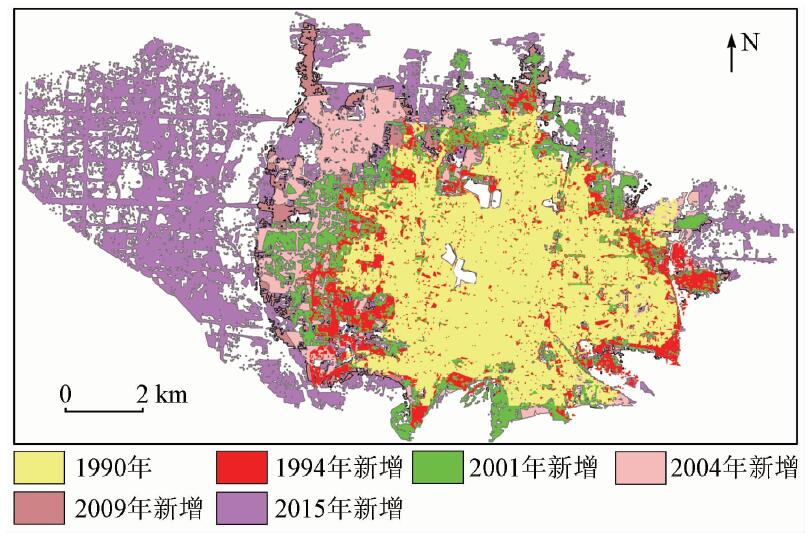
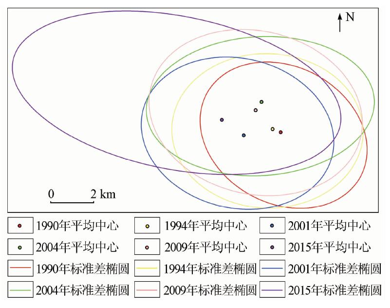
Abstract With the deepening of urbanization, the problem of urban expansion has become more and more prominent, and the problem of land resource waste and eco-environment pollution has also occurred with urban expansion. Based on the support vector machine (SVM) classification method and the way of man-computer interactive interpretation, the authors classified the land of Kaifeng and extracted the city proper, analyzed the urban construction land expansion and spatial distribution in the past 25 years by using the indexes such as expansion speed index (ESI), expansion intensity index (EII), mean center (MC) and standard deviational ellipse (SDE), and analyzed the drive factor of urban expansion based on the social statistics. The results reveal that, firstly, the urban construction land of Kaifeng expands from 38.08 km 2 in 1990 to 125.86 km 2 in 2015, with the expansion speed reaching 3.51 km 2/a. Secondly, MC and SDE show that the average central position of Kaifeng City has changed a little in the past 25 years, it has moved northwest entirety, and the spatial distribution of construction land tended to expand evenly from 1990 to 2009, the construction area continued to expand and the spatial distribution was directional obviously from 2009 to 2015. Finally, it is concluded that the quantity of urban population and the economic development are the main driving forces of urban expansion in Kaifeng City.
|
| Keywords
supervised classification
urban expansion
expansion intensity
SDE
driving factors
|
|
|
|
Issue Date: 07 December 2018
|
|
|
| [1] |
常变蓉, 李仁东 . 武汉市建设用地扩张遥感监测及空间分异分析[J]. 国土资源遥感, 2017,29(3):118-123.doi: 10.6046/gtzyyg.2017.03.17.
doi: 10.6046/gtzyyg.2017.03.17
url: http://d.wanfangdata.com.cn/Periodical/gtzyyg201703017
|
| [1] |
Chang B R, Li R D . A study of remote sensing monitoring and spatial variation of construction land expansion in Wuhan City[J]. Remote Sensing for Land and Resources, 2017,29(3):118-123.doi: 10.6046/gtzyyg.2017.03.17.
|
| [2] |
Masek J G, Undsay F E, Gowarf S N . Dynamics of urban growth in the Washingto DC metropolitan area,1973—1996,from Landsat observation[J]. International Journal of Remote sensing, 2000,21(18):3473-3486.
doi: 10.1080/014311600750037507
url: https://www.tandfonline.com/doi/full/10.1080/014311600750037507
|
| [3] |
Braimoh A K, Onishi T . Spatial determinants of urban land use change in Lagos Nigeria[J]. Land Use Policy, 2007,24(2):502-515.
doi: 10.1016/j.landusepol.2006.09.001
url: http://linkinghub.elsevier.com/retrieve/pii/S0264837706000846
|
| [4] |
何春阳, 史培军, 陈晋 , 等. 北京地区城市化过程与机制研究[J]. 地理学报, 2002,57(3):363-371.
doi: 10.3321/j.issn:0375-5444.2002.03.013
url: http://d.wanfangdata.com.cn/Periodical_dlxb200203013.aspx
|
| [4] |
He C Y, Shi P J, Chen J , et al. Study on urbanization process and mechanism in Beijing[J]. Acta Geographica Sinica, 2002,57(3):363-371.
|
| [5] |
曾永年, 张璎璎, 张鸿辉 , 等. 城市扩展强度及其地表热特性遥感定量分析[J] 测绘学报, 2010,39(1):65-71.
|
| [5] |
Zeng Y N, Zhang Y Y, Zhang H H , et al. A quantitative analysis of urban growth and associated thermal characteristics using remote sensing data[J]. Acta Geodaetica et Cartographica Sinica, 2010,39(1):65-71.
|
| [6] |
刘庆, 陈利根, 何长元 , 等. 长株潭城市群耕地动态变化及驱动力实证研究[J]. 地域研究与开发, 2010,29(4):123-126.
|
| [6] |
Liu Q, Chen L G, He C Y , et al. Empirical study on trendand driving forces of cultivated land dynamic change in Changsha-Zhuzhou-Xiangtan urban agglomerations[J]. Areal Research and Development, 2010,29(4):123-126.
|
| [7] |
杨晓楠, 徐韵, 田玉刚 . 一种用于城市信息提取的改进居民地指数[J]. 国土资源遥感, 2016,28(4):127-134.doi: 10.6046/gtzyyg.2016.04.20.
doi: 10.6046/gtzyyg.2016.04.20
url: http://www.cqvip.com/QK/91397X/201604/670742313.html
|
| [7] |
Yang X N, Xu Y, Tian Y G . An improved residential land index for urban information extraction[J]. Remote Sensing for Land and Resources, 2016,28(4):127-134.doi: 10.6046/gtzyyg.2016.04.20.
|
| [8] |
刘盛和, 吴传钧, 沈洪泉 . 基于GIS的北京城市土地利用扩展模式[J]. 地理学报, 2000,67(4):407-416.
|
| [8] |
Liu S H, Wu C J, Shen H Q . A GIS based model of urban land use growth in Beijing[J]. Acta Geographica Sinica, 2000,67(4):407-416.
|
| [9] |
华伟, 赵芳 . 都市扩张与土地资源利用集约化——关于上海市城市发展模式的研究[J]. 长江流域资源与环境, 1998,7(3):2-6.
url: http://www.cqvip.com/Main/Detail.aspx?id=3147242
|
| [9] |
Hua W, Zhao F . Urban sprawl and intensive use of land resources:A study on the urban development model of Shanghai City[J]. Resources and Environment in the Yangtze Basin, 1998,7(3):2-6.
|
| [10] |
吴次芳, 陆张维, 杨志荣 , 等. 中国城市化与建设用地增长动态关系的计量研究[J]. 中国土地科学, 2009,23(2):18-23.
doi: 10.3969/j.issn.1001-8158.2009.02.003
url: http://d.wanfangdata.com.cn/Periodical/zhonggtdkx200902003
|
| [10] |
Wu C F, Lu Z W, Yang Z R , et al. A quantitative study of the dynamic relationship between urbanization and construction land growth in China[J]. China Land Science, 2009,3(2):18-23.
|
| [11] |
《开封市城市总体规划(2011—2020)》[R]. 国务院办公厅,2017-1-26.
|
| [11] |
“The Overall Planning of Kaifeng City(2011—2020)”[R]. General Office of the State Council,2017-1-26.
|
| [12] |
陆玭, 汤茂林, 刘茂松 . 基于RS和GIS的江阴城市扩张研究[J]. 南京师大学报(自然科学版), 2010,33(2):132-137.
|
| [12] |
Lu P, Tang M L, Liu M S . Research of Jiangyin City expansion based on RS and GIS[J]. Journal of Nanjing Normal University (Natural Science Edition), 2010,33(2):132-137.
|
| [13] |
李军, 谢宗孝 . 武汉市产业结构与城市用地及空间形态的变化[J]. 武汉大学学报(工学版), 2002,35(5):29-32.
doi: 10.3969/j.issn.1671-8844.2002.05.006
url: http://d.wanfangdata.com.cn/Periodical/whsldldxxb200205006
|
| [13] |
Li J, Xie Z X . Wuhan municipal industrial structure and urban land use and adjustment of their spatial form[J]. Engineering Journal of Wuhan University, 2002,35(5):29-32.
|
| [14] |
陈阳, 李伟芳, 任丽燕 , 等. 空间统计视角下的农村居民点分布变化及驱动因素分析——以滨海平原为例[J]. 资源科学, 2014,36(11):2273-2281.
url: http://d.wanfangdata.com.cn/Periodical/zykx201411006
|
| [14] |
Chen Y, Li W F, Ren L Y , et al. Changes in the distribution of rural residential land on a coastal plain[J]. Resources Science, 2014,36(11):2273-2281.
|
| [15] |
邓羽, 司月芳 . 北京市城区扩展的空间格局与影响因素[J]. 地理研究, 2015,34(12):2247-2256.
doi: 10.11821/dlyj201512004
url: http://www.cqvip.com/QK/95732X/201512/667628678.html
|
| [15] |
Deng Y, Si Y F . The spatial pattern and influence factors of urban expansion:A case study of Beijing[J]. Geographical Research, 2015,34(12):2247-2256.
|
| [16] |
胡长慧 . 开封城市用地扩张时空特征及驱动力分析[D]. 开封:河南大学, 2014.
|
| [16] |
Hu C H . Analysis of Spatial and Temporal Characteristics and Driving Forces of Urban Land Expansion in Kaifeng[D]. Kaifeng:Henan University, 2014.
|
| [17] |
徐小明, 杜自强, 张红 , 等. 晋北地区1986—2010年土地利用/覆盖变化的驱动力[J]. 中国环境科学, 2016,36(7):2154-2161.
url: http://d.wanfangdata.com.cn/Periodical/zghjkx201607037
|
| [17] |
Xu X M, Du Z Q, Zhang H , et al. Quantitative analysis on driving forces of land use/cover chang in north Shanxi Province during 1986—2010[J]. China Environmental Science, 2016,36(7):2154-2161.
|
| [18] |
赵岑, 冯长春 . 我国城市化进程中国城市人口与城市用地相互关系研究[J]. 城市发展研究, 2010,17(10):113-118.
|
| [18] |
Zhao C, Feng C C . Research on the interrelation between urban land use and population in urbanization process of China[J]. Urban Studies, 2010,17(10):113-118.
|
| [19] |
张琦, 金继红, 张坤 , 等. 日本和韩国土地利用与经济发展关系实证分析及启示[J]. 资源科学, 2007,29(2):149-155.
doi: 10.3321/j.issn:1007-7588.2007.02.023
url: http://www.cqvip.com/Main/Detail.aspx?id=24047188
|
| [19] |
Zhang Q, Jin J H, Zhang K , et al. Empirical analysis and enlightenment of land use and economic development in Japan and South Korea[J]. Resources Science, 2007,29(2):149-155.
|
| [20] |
王寅龙 .郑汴地区总体规划评审会召开[N].开封日报, 2009 -11-20(001).
|
| [20] |
Wang Y L . Zhangzhou-Kaifeng district general planning review meeting[N].Kaifeng Daily, 2009 -11-20(001).
|
| [21] |
开封城市总体规划(2008—2020)[R]. 开封市人民政府, 2009.
|
| [21] |
Master Plan of Kaifeng City (2008—2020) [R]. The People’s Government of Kaifeng City, 2009.
|
| [22] |
杨牡丹 . 交通基础设施建设与城市群一体化发展研究[D]. 上海:华东师范大学, 2013.
|
| [22] |
Yang M D . Study on the Influence of Transportation Infrastructure and Urban Agglomeration Integration[D]. Shanghai:East China Normal University, 2013.
|
|
Viewed |
|
|
|
Full text
|
|
|
|
|
Abstract
|
|
|
|
|
Cited |
|
|
|
|
| |
Shared |
|
|
|
|
| |
Discussed |
|
|
|
|
 2018,
Vol. 30
2018,
Vol. 30