|
|
 |
|

|
|
|
Extraction of alteration information from hyperspectral core imaging based on wavelet packet transform and weight spectral angle mapper |
| Qinglin TIAN1, Wei PAN1, Yao LI2, Chuan ZHANG1, Xuejiao CHEN1, Zhangfa YU1 |
1. National Key Laboratory of Remote Sensing Information and Image Analysis Technology, Beijing Research Institute of Uranium Geology, Beijing 100029, China
2. Zachry Department of Civil Engineering, Texas A&M University, Texas 77843, USA |
|
|
|
|
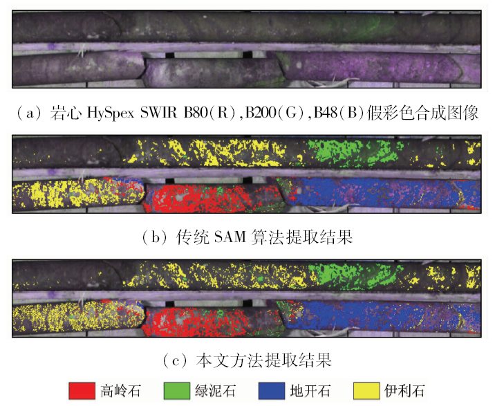
Abstract Hyperspectral data are characterized by many bands, but the strong correlation between the adjacent bands makes it redundant and ineffective, which becomes a challenge for information extraction. To solve this problem, this paper proposes a method combining wavelet packet transform and weight SAM. First, radiometric calibration, reflectivity calculation and wavelet denoising are conducted on the raw hyperspectral data. Second, by using daubechies4 as the wavelet basis, the target and reference spectra are both processed with an 8-layer wavelet packet decomposition, and information entropy feature vector is based on the decomposition coefficient to characterize the features of the raw spectra. Third, efforts are made to find the feature range, in which the difference in information entropy feature vector between the target and reference spectra is huge, and a weight in this range is set. Finally, alteration minerals are mapped according to the SAM principle. In this study, experiments were conducted to testify the feasibility and effectiveness of the method by using the HySpex SWIR hyperspectral core data of a volcanic type uranium deposit in southern China. The results indicate that the new algorithm can efficiently characterize the raw spectral information by using the wavelet packet information entropy feature vector. Furthermore, the local characteristic information can be extruded by setting difference feature range, and different minerals can be more easily distinguished by this method with a total classification accuracy of 75.33% and a kappa coefficient of 0.706 3. The method proposed by the authors performs better than the traditional SAM algorithm and has a great application potential.
|
| Keywords
wavelet packet
spectral angle mapper (SAM)
hyperspectral core
alteration information
|
|
|
|
Issue Date: 03 December 2019
|
|
|
| [1] |
杜培军, 夏俊士, 薛朝辉 , 等. 高光谱遥感影像分类研究进展[J]. 遥感学报, 2016,20(2):236-256.
|
| [1] |
Du P J, Xia J S, Xue Z H , et al. Review of hyperspectral remote sensing image classification[J]. Journal of Remote Sensing, 2016,20(2):236-256.
|
| [2] |
杨达昌, 陈洁, 高子弘 , 等. 天宫一号高光谱数据烃类微渗漏信息提取[J]. 国土资源遥感, 2018,30(2):107-113.doi: 10.6046/gtzyyg.2018.02.15.
|
| [2] |
Yang D C, Chen J, Gao Z H , et al. Extraction of hydrocarbon micro-seepage information based on TG-1 hyperspectral data[J]. Remote Sensing for Land and Resources, 2018,30(2):107-113.doi: 10.6046/gtzyyg.2018.02.15.
|
| [3] |
钮宇斌, 王斌 . 一种新的用于高光谱图像小目标探测的目标光谱学习算法[J]. 红外与毫米波学报, 2017,36(4):471-480.
url: http://www.opticsjournal.net/Articles/Abstract?aid=OJ171012000071SpVrYu
|
| [3] |
Niu Y B, Wang B . A novel target spectrum learning algorithm for small target detection in hyperspectral imagery[J]. Journal of Infrared and Millimeter Waves, 2017,36(4):471-480.
|
| [4] |
Mulla D J . Twenty five years of remote sensing in precision agriculture:Key advances and remaining knowledge gaps[J]. Biosystems Engineering, 2013,114(4):358-371.
|
| [5] |
Li X K, Wu T X, Liu K , et al. Evaluation of the Chinese fine spatial resolution hyperspectral satellite TianGong-1 in urban land-cover classification[J]. Remote Sensing, 2016,8(5):438-454.
|
| [6] |
刘凯, 张立福, 杨杭 , 等. 面向对象分析的非结构化背景目标高光谱探测方法研究[J]. 光谱学与光谱分析, 2013,33(6):1653-1657.
url: http://www.opticsjournal.net/Articles/Abstract?aid=OJ1306070001074z7C9F
|
| [6] |
Liu K, Zhang L F, Yang H , et al. Hyperspectral unstructured background target detection approach based on object-oriented analysis[J]. Spectroscopy and Spectral Analysis, 2013,33(6):1653-1657.
|
| [7] |
Bedini E . Mineral mapping in the Kap Simpson complex,central East Greenland,using HyMap and ASTER remote sensing data[J]. Advances in Space Research, 2011,47(1):60-73.
|
| [8] |
姚佳蕾, 张川, 叶发旺 , 等. 相山邹家山铀矿区某钻孔岩心高光谱蚀变矿物特征及地质意义[J]. 铀矿地质, 2017,33(6):376-380.
|
| [8] |
Yao J L, Zhang C, Ye F W , et al. Hyperspectral alteration mineral feature and its geological significance of drill core in Zoujiashan uranium deposit of Xiangshan orefield[J]. Uranium Geology, 2017,33(6):376-380.
|
| [9] |
Hamza M H , Al-Thubaiti A S,Dhieb M,et al.Dasymetric mapping as a tool to access the spatial distribution of population in Jeddah City (Kingdom of Saudi Arabia)[J]. Current Urban Studies, 2016,4(4):329-342.
|
| [10] |
何中海, 何彬彬 . 基于权重光谱角制图的高光谱矿物填图方法[J]. 光谱学与光谱分析, 2011,31(8):2200-2204.
url: http://www.opticsjournal.net/Articles/Abstract?aid=OJ1108290001302y5A8D
|
| [10] |
He Z H, He B B . Weight spectral angle mapper (WSAM) method for hyperspectral mineral mapping[J]. Spectroscopy and Spectral Analysis, 2011,31(8):2200-2204.
|
| [11] |
张媛, 张杰林, 赵学胜 , 等. 基于峰值权重的岩心高光谱矿化蚀变信息提取[J]. 国土资源遥感, 2015,27(2):154-159.doi: 10.6046/gtzyyg.2015.02.24.
doi: 10.6046/gtzyyg.2015.02.24
|
| [11] |
Zhang Y, Zhang J L, Zhao X S , et al. Extraction of mineral alteration information from core hyperspectral images based on weight of absorption peak[J]. Remote Sensing for Land and Resources, 2015,27(2):154-159.doi: 10.6046/gtzyyg.2015.02.24.
|
| [12] |
吕银亮, 李少昆, 王克如 , 等. 基于改进光谱角算法的小麦产量监测研究[J]. 新疆农业科学, 2011,48(1):1-5.
|
| [12] |
Lyu Y L, Li S K, Wang K R , et al. Studies monitoring yield of winter wheat with a modified spectral angle algorithm[J]. Xinjiang Agricultural Sciences, 2011,48(1):1-5.
|
| [13] |
Seo Y, Kim S . River stage forecasting using wavelet packet decomposition and data-driven models[J]. Procedia Engineering, 2016,154:1225-1230.
|
| [14] |
Zhang X Y, Li P J . Lithological mapping from hyperspectral data by improved use of spectral angle mapper[J]. International Journal of Applied Earth Observation and Geoinformation, 2014,31(5):95-109.
|
| [15] |
岑奕, 张艮中, 张立福 , 等. 地物光谱不确定性及光谱角制图算法适用性研究[J]. 光谱学与光谱分析, 2015,35(10):2841-2845.
url: http://www.opticsjournal.net/Articles/Abstract?aid=OJ160202000184OkRnTq
|
| [15] |
Cen Y, Zhang G Z, Zhang L F , et al. Spectral uncertainty of terrestrial objects and the applicability of spectral angle mapper algorithm[J]. Spectroscopy and Spectral Analysis, 2015,35(10):2841-2845.
|
| [16] |
田茂杰 . 基于Hyperion与SASI数据的矿物填图方法对比研究[D].北京:中国地质大学( 北京), 2017.
|
| [16] |
Tian M J . Comparative Study of Mineral Mapping Methods Based on Hyperion and SASI Data[D].Beijing:China University of Geosciences ( Beijing), 2017.
|
| [17] |
Sankar A S, Nair S S, Dharan V S , et al. Wavelet sub band entropy based feature extraction method for BCI[J]. Procedia Computer Science, 2015,46:1476-1482.
|
| [18] |
郭辉, 杨可明, 张文文 , 等. 小波包信息熵特征矢量光谱角高光谱影像分类[J]. 中国图象图形学报, 2017,22(2):205-211.
|
| [18] |
Guo H, Yang K M, Zhang W W , et al. Classification of a hyperspectral image based on wavelet packet entropy feature vector angle[J]. Journal of Image and Graphics, 2017,22(2):205-211.
|
| [19] |
张川, 叶发旺, 徐清俊 , 等. 钻孔岩心高光谱技术系统及其在矿产勘查中的应用[J]. 地质科技情报, 2016,35(6):177-183.
|
| [19] |
Zhang C, Ye F W, Xu Q J , et al. Drill core hyperspectral technology system and its application in mineral prospecting[J]. Geological Science and Technology Information, 2016,35(6):177-183.
|
| [20] |
张川, 叶发旺, 姚佳蕾 , 等. 成像光谱钻孔岩芯编录的实现方法[J]. 遥感信息, 2017,32(5):69-74.
|
| [20] |
Zhang C, Ye F W, Yao J L , et al. Implementation method of drill core logging based on imaging spectrometer[J]. Remote Sensing Information, 2017,32(5):69-74.
|
|
Viewed |
|
|
|
Full text
|
|
|
|
|
Abstract
|
|
|
|
|
Cited |
|
|
|
|
| |
Shared |
|
|
|
|
| |
Discussed |
|
|
|
|
 2019,
Vol. 31
2019,
Vol. 31