|
|
 |
|

|
|
|
Downscaling of TRMM precipitation products and its application in Xiangjiang River basin |
FAN Tianyi1,2( ), ZHANG Xiang2(), HUANG Bing1, QIAN Zhan1, JIANG Heng1 ), ZHANG Xiang2(), HUANG Bing1, QIAN Zhan1, JIANG Heng1 |
1. Research Center of Dongting Lake, Hunan Hydro & Power Design Institute, Changsha 410007, China
2. State Key Lab of Water Resources and Hydropower Engineering Science, Wuhan University, Wuhan 430072, China |
|
|
|
|
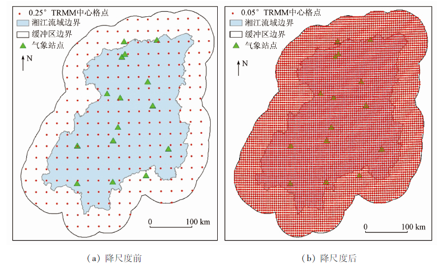
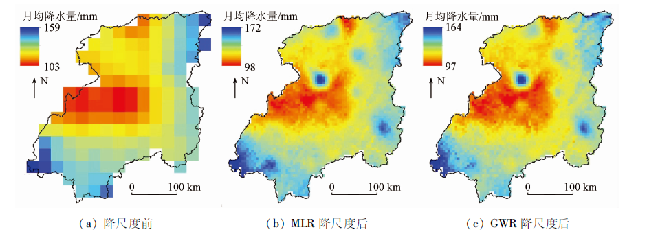
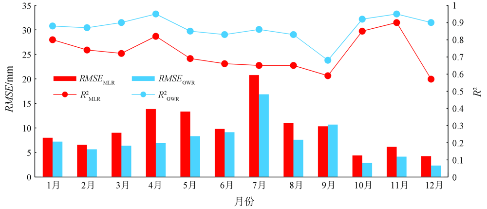
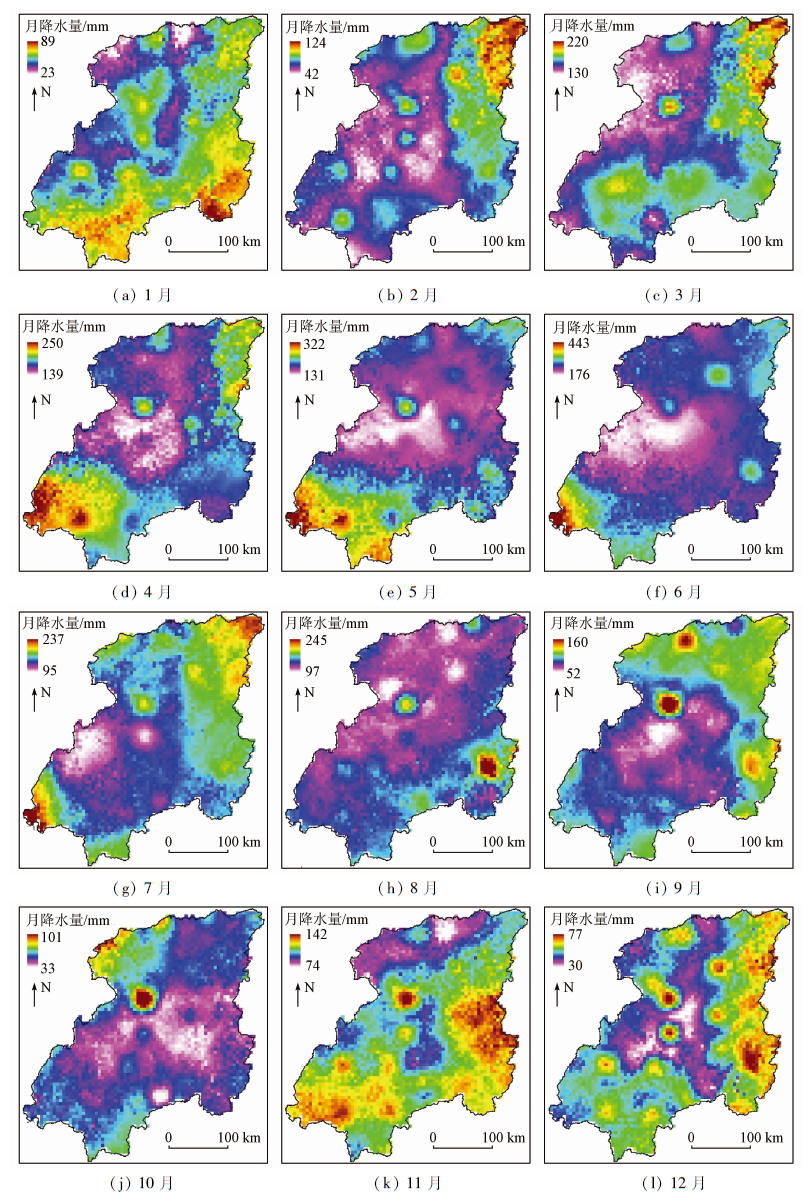
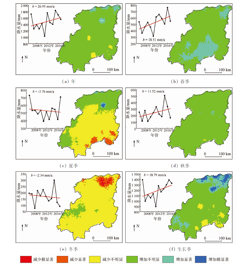
Abstract To meet the demand of various industries for high-resolution and high-precision precipitation data, this study establishes the downscaling models of the TRMM precipitation data of the Xiangjiang River basin based on the methods of multivariate linear regression (MLR) and geographically weighted regression (GWR). The leave-one-out cross-validation method was adopted to select the optimal model, and a satellite-ground fusion precipitation product with a resolution of 0.05° was obtained through inversion. On this basis, the spatial-temporal change characteristics of the precipitation in the Xiangjiang River basin were analyzed. The results are as follows. The spatial resolution of the TRMM precipitation data was greatly improved after downscaling. As verified using the precipitation observed at meteorological stations, the coefficient of determination of the TRMM precipitation data increased by more than 0.27, and the root mean square error and average relative error of the TRMM precipitation data decreased by more than 28.42 mm and 29.88 percentage points, respectively on average after downscaling. All these indicate that the regression downscaling model that takes account of vegetation, terrain, and geographic elements can accurately describe the spatial distribution characteristics of precipitation. According to the verification using the precipitation observed at meteorological stations, the coefficient of determination of the GWR downscaling model increased by 0.06 compared to the MLR downscaling model. Meanwhile, the root mean square error and average relative error of the precipitation data obtained using the GWR downscaling model decreased by 14.88 mm and 8.83 percentage points, respectively on average compared to precipitation data obtained using the MLR downscaling model. These indicate better effects of the GWR downscaling model. The spatial-temporal change characteristics of the precipitation in the Xiangjiang River basin during 2006—2017 are greatly different on different time scales, which is reflected in the changing trend and its significance and the locations and area of corresponding zones.
|
| Keywords
TRMM
spatial downscaling
spatiotemporal variation
Xiangjiang River basin
|
|
|
|
Corresponding Authors:
ZHANG Xiang
E-mail: 1723257974@qq.com;zhangxiang@whu.edu.cn
|
|
Issue Date: 23 December 2021
|
|
|
| [1] |
胡庆芳. 基于多源信息的降水空间估计及其水文应用研究[D]. 北京:清华大学, 2013.
|
| [1] |
Hu Q F. Rainfall spatial estimation using multi-source information and its hydrological application[D]. Beijing:Tsinghua University, 2013.
|
| [2] |
袁飞, 赵晶晶, 任立良, 等. TRMM多卫星测雨数据在赣江上游径流模拟中的应用[J]. 天津大学学报(自然科学与工程技术版), 2013,46(7):611-616.
|
| [2] |
Yuan F, Zhao J J, Ren L L, et al. Streamflow simulation in the Upper Ganjiang River Basin using the TRMM multi-satellite precipitation data[J]. Journal of Tianjin University(Science and Technology), 2013,46(7):611-616.
|
| [3] |
李哲. 多源降雨观测与融合及其在长江流域的水文应用[D]. 北京:清华大学, 2015.
|
| [3] |
Li Z. Multi-source precipitation observations and fusion for hydrological applications in the Yangtze River Basin[D]. Beijing:Tsinghua University, 2015.
|
| [4] |
王存光, 洪阳. 卫星遥感降水的反演、验证与应用综述[J]. 水利水电技术, 2018,49(8):4-12.
|
| [4] |
Wang C G, Hong Y. Review on inversion,verification and application of satellite remote sensing of precipitation[J]. Water Resources and Hydropower Engineering, 2018,49(8):4-12.
|
| [5] |
Hamid E Y, Kawasaki Z, Mardiana R. Impact of the 1997—98 El Niño Event on lightning activity over Indonesia[J]. Geophysical Research Letters, 2001,28(1):147-150.
doi: 10.1029/2000GL011374
url: http://doi.wiley.com/10.1029/2000GL011374
|
| [6] |
Chen Y, Genio A D, Chen J. The tropical atmospheric El Nino signal in satellite precipitation data and a global climate model[J]. Journal of Climate, 2007,20(14):3580-3601.
doi: 10.1175/JCLI4208.1
url: http://journals.ametsoc.org/doi/10.1175/JCLI4208.1
|
| [7] |
Li X H, Zhang Q, Xu C Y. Suitability of the TRMM satellite rainfalls in driving a distributed hydrological model for water balance computations in Xinjiang catchment,Poyang Lake Basin[J]. Journal of hydrology, 2012, 426-427:28-38.
doi: 10.1016/j.jhydrol.2012.01.013
url: https://linkinghub.elsevier.com/retrieve/pii/S002216941200056X
|
| [8] |
陈诚, 赵书河. 基于TRMM降雨数据的中国黄淮海地区干旱监测分析[J]. 国土资源遥感, 2016,28(1):122-129.doi: 10.6046/gtzyyg.2016.01.18.
doi: 10.6046/gtzyyg.2016.01.18
|
| [8] |
Chen C, Zhao S H. Drought monitoring and analysis of Huanghuai Hai plain based on TRMM precipitation data[J]. Remote Sensing for Land and Resources, 2016,28(1):122-129.doi: 10.6046/gtzyyg.2016.01.18.
doi: 10.6046/gtzyyg.2016.01.18
|
| [9] |
魏志明, 岳官印, 李家, 等. GPM与TRMM降水数据在海河流域的精度对比研究[J]. 水土保持通报, 2017,37(2):171-176.
|
| [9] |
Wei Z M, Yue G Y, Li J, et al. Comparison study on accuracies of precipitation data using GPM and TRMM product in Haihe River Basin[J]. Bulletin of Soil and Water Conservation, 2017,37(2):171-176.
|
| [10] |
甘富万, 余膳男, 黄宇明, 等. TRMM卫星降水产品在南流江流域的精度评估[J]. 水力发电, 2018,44(11):21-25,43.
|
| [10] |
Gan F W, Yu S N, Huang Y M, et al. Accuracy evaluation of TRMM multi-satellite precipitation analysis over Nanliu River Basin[J]. Water Power, 2018,44(11):21-25,43.
|
| [11] |
李蒙, 秦天玲, 刘少华, 等. 怒江上游TRMM 3B42V7降水产品资料时空验证及降水特征分析[J]. 高原气象, 2017,36(4):950-959.
|
| [11] |
Li M, Qin T L, Liu S H, et al. Spatial-temporal validation of TRMM 3B42V7 precipitation products and analysis of precipitation characteristics in the upper reaches of Nujiang River[J]. Plateau Meteorology, 2017,36(4):950-959.
|
| [12] |
李运龙, 熊立华, 闫磊. 基于地理加权回归克里金的降水数据融合及其在水文预报中的应用[J]. 长江流域资源与环境, 2017,26(9):1359-1368.
|
| [12] |
Li Y L, Xiong L H, Yan L. A geographically weighted regression Kriging approach for TRMM-rain gauge data merging and its application in hydrological forecasting[J]. Resources and Environment in the Yangtze Basin, 2017,26(9):1359-1368.
|
| [13] |
王晓杰. 基于TRMM的天山山区降水降尺度方法及其空间变异特征研究[D]. 石河子:石河子大学, 2013.
|
| [13] |
Wang X J. Downscaling method and spatial variability of precipitation in Tianshan Mountain based on the TRMM date[D]. Shihezi:Shihezi University, 2013.
|
| [14] |
Immerzeel W W, Rutten M M, Droogers P. Spatial downscaling of TRMM precipitation using vegetative response on the Iberian Peninsula[J]. Remote Sensing of Environment, 2009,113(2):362-370.
doi: 10.1016/j.rse.2008.10.004
url: https://linkinghub.elsevier.com/retrieve/pii/S0034425708003155
|
| [15] |
Duan Z, Bastiaanssen W. First results from Version 7 TRMM 3B43 precipitation product in combination with a new downscaling-calibration procedure[J]. Remote Sensing of Environment, 2013,131:1-13.
doi: 10.1016/j.rse.2012.12.002
url: https://linkinghub.elsevier.com/retrieve/pii/S0034425712004580
|
| [16] |
熊俊楠, 李伟, 刘志奇, 等. 基于GWR模型的青藏高原地区TRMM数据降尺度研究[J]. 国土资源遥感, 2019,31(4):88-95.doi: 10.6046/gtzyyg.2019.04.12.
doi: 10.6046/gtzyyg.2019.04.12
|
| [16] |
Xiong J N, Li W, Liu Z Q, et al. Research on downscaling of TRMM data in the Tibetan Plateau based on GWR model[J]. Remote Sensing for Land and Resources, 2019,31(4):88-95.doi: 10.6046/gtzyyg.2019.04.12.
doi: 10.6046/gtzyyg.2019.04.12
|
| [17] |
曾昭昭, 王晓峰, 任亮. 基于GWR模型的陕西秦巴山区TRMM降水数据降尺度研究[J]. 干旱区地理, 2017,40(1):26-36.
|
| [17] |
Zeng Z Z, Wang X F, Ren L. Spatial downscaling of TRMM rainfall data based on GWR model for Qinling-Daba Mountains in Shaanxi Province[J]. Arid Land Geography, 2017,40(1):26-36.
|
| [18] |
Zeng Q, Chen H, Xu C Y, et al. Feasibility and uncertainty of using conceptual rainfall-runoff models in design flood estimation[J]. Hydrology Research, 2016,47(4):701-717.
doi: 10.2166/nh.2015.069
url: https://iwaponline.com/hr/article/47/4/701/935/Feasibility-and-uncertainty-of-using-conceptual
|
| [19] |
杜军凯, 贾仰文, 李晓星, 等. 基于TRMM卫星降水的太行山区降水时空分布格局[J]. 水科学进展, 2019,30(1):1-13.
|
| [19] |
Du J K, Jia Y W, Li X X, et al. Study on the spatial-temporal distribution pattern of precipitation in the Taihang Mountain region using TRMM data[J]. Advances in Water Science, 2019,30(1):1-13.
|
| [20] |
赵娜, 焦毅蒙. 基于TRMM降水数据的空间降尺度模拟[J]. 地球信息科学学报, 2018,20(10):20-27.
|
| [20] |
Zhao N, Jiao Y M. Downscaling of TRMM satellite precipitation data[J]. Journal of Geo-Information Science, 2018,20(10):20-27.
|
| [21] |
范雪薇, 刘海隆. 天山山区TRMM降水数据的空间降尺度研究[J]. 自然资源学报, 2018,33(3):478-488.
|
| [21] |
Fan X W, Liu H L. Spatial downscaling of TRMM precipitation data in Tianshan Mountains[J]. Journal of Natural Resources, 2018,33(3):478-488.
|
| [22] |
何其全, 史岚, 谭璐璐, 等. 中国中东部区域TRMM降水产品降尺度研究及其时空特征分析[J]. 气象科学, 2019,39(3):312-321.
|
| [22] |
He Q Q, Shi L, Tan L L, et al. Downscaling research and temporal and spatial characteristics of TRMM precipitation products in the central and eastern regions of China[J]. Meteorological Science, 2019,39(3):312-321.
|
| [23] |
Chen C, Zhao S, Duan Z, et al. An improved spatial downscaling procedure for TRMM 3B43 precipitation product using geographically weighted regression[J]. IEEE Journal of Selected Topics in Applied Earth Observations and Remote Sensing, 2015,8(9):4592-4604.
doi: 10.1109/JSTARS.4609443
url: https://ieeexplore.ieee.org/xpl/RecentIssue.jsp?punumber=4609443
|
| [24] |
范永东. 模型选择中的交叉验证方法综述[D]. 太原:山西大学, 2013.
|
| [24] |
Fan Y D. A summary of cross-validation in model selection[D]. Taiyuan:Shanxi University, 2013.
|
| [25] |
姜瑶, 徐宗学, 王静. 基于年径流序列的五种趋势检测方法性能对比[J]. 水利学报, 2020,51(7):845-857.
|
| [25] |
Jiang Y, Xu Z X, Wang J. Comparison among five methods of trend detection for annual runoff series[J]. Journal of Hydraulic Engineering, 2020,51(7):845-857.
|
| [26] |
刘小婵, 张洪岩, 赵建军, 等. 东北地区TRMM数据降尺度的GWR模型分析[J]. 地球信息科学学报, 2015,17(9):1055-1062.
|
| [26] |
Liu X C, Zhang H Y, Zhao J J, et al. Spatial downscaling of TRMM precipitation data based on GWR model in Northeast China[J]. Journal of Geo-Information Science, 2015,17(09):1055-1062.
|
| [27] |
范田亿, 张翔. 2000—2014年中国粮食主产区植被水分利用效率时空演变特征研究[J]. 灌溉排水学报, 2019,38(3):99-107.
|
| [27] |
Fan T Y, Zhang X. Analysis of the spatial-temporal characteristics of water use efficiency of vegetation in the main grain production area of China from 2000 to 2014[J]. Journal of Irrigation and Drainage, 2019,38(3):99-107.
|
| [28] |
宁珊, 张正勇, 刘琳, 等. TRMM偏最小二乘降尺度降水模型在新疆不同地貌的适应性[J]. 农业工程学报, 2020,36(12):99-109.
|
| [28] |
Ning S, Zhang Z Y, Liu L, et al. Adaptability of precipitation estimation method based on TRMM data combined with partial least squares downscaling in different landforms of Xinjiang, China[J]. Transactions of the Chinese Society of Agricultural Engineering, 2020,36(12):99-109.
|
|
Viewed |
|
|
|
Full text
|
|
|
|
|
Abstract
|
|
|
|
|
Cited |
|
|
|
|
| |
Shared |
|
|
|
|
| |
Discussed |
|
|
|
|
 2021,
Vol. 33
2021,
Vol. 33